Please use this identifier to cite or link to this item:
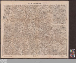
http://dx.doi.org/10.25673/39263| Title: | Karte des unteren Werratales / herausgegeben vom Reichsamt für Landesaufnahme ; Hauptwanderwege, Nebenwanderwege eingetragen von Prof. Ulrich, Eschwege |
| Publisher / Printer: | Deutsches Reich |
| Published: | Berlin : Verlag des Reichsamts für Landesaufnahme, 1922 |
| Scale: | 1:100 000 |
| Extent: | 1 Karte; 58 x 71 cm, gefaltet 22 x 14 cm farbig |
| Annotations: | Nebenkarte rechts oben: "Der Meißner" Mit Bergstrichen und Höhenlinien Ohne Kartennetz Karte |
| Language: | German |
| Subjects: | Untere-Werra-Tal Topografische Karte Wanderkarte |
| Online Edition: | Halle (Saale) : Universitäts- und Landesbibliothek Sachsen-Anhalt, 2021 |
| Original Publication: | Universitäts- und Landesbibliothek Sachsen-Anhalt, 21 C 81 |
| URN: | urn:nbn:de:gbv:3:3-1192015415-269043705-17 |
| URI: | https://opendata.uni-halle.de//handle/1981185920/41217 http://dx.doi.org/10.25673/39263 |
| Open Access: |  Open access publication Open access publication |
| License: |  Creative Commons Attribution 4.0") (CC BY 4.0) Creative Commons Attribution 4.0 (CC BY 4.0) Creative Commons Attribution 4.0 |
| Sponsor/Funder: | Die Digitalisierung wurde durch die Deutsche Digitale Bibliothek im Rahmen des von der Beauftragten der Bundesregierung für Kultur und Medien (BKM) geförderten Programms NEUSTART KULTUR ermöglicht. |
| Appears in Collections: | Karten und Atlanten |
Ressources:
 |
|