Please use this identifier to cite or link to this item:
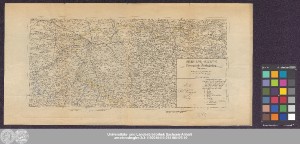
http://dx.doi.org/10.25673/39047| Title: | Special-Karte der Preussisch-Sächsischen Grenze / entworfen und gezeichnet von A.A. Müller |
| Publisher / Printer: | Knapp, Georg Carl G. C. Knapp's Verlag |
| Published: | Halle : G.C. Knapp's Verlag ; Halle (Saale), [circa 1860] |
| Publication place: | Halle (Saale) |
| Scale: | Circa 1:410 000 |
| Extent: | 1 Karte; 16 x 35 cm Kupferstich |
| Annotations: | Maßstab in grafischer Form (geogr. Meilen) Titel-, Erklärungs- und Verlegerkartusche unten rechts Auf 2 Blättern gedruckt Karte |
| Note: | Koloriert |
| Language: | German |
| Subjects: | Preußen Sachsen Staatsgrenze |
| Online Edition: | Halle (Saale) : Universitäts- und Landesbibliothek Sachsen-Anhalt, 2021 |
| Original Publication: | Universitäts- und Landesbibliothek Sachsen-Anhalt, Altkt A IV 3 [13] 8 |
| URN: | urn:nbn:de:gbv:3:3-1192015415-245105476-10 |
| URI: | https://opendata.uni-halle.de//handle/1981185920/39294 http://dx.doi.org/10.25673/39047 |
| Open Access: |  Open access publication Open access publication |
| License: |  Creative Commons Attribution 4.0") (CC BY 4.0) Creative Commons Attribution 4.0 (CC BY 4.0) Creative Commons Attribution 4.0 |
| Sponsor/Funder: | Die Digitalisierung wurde durch die Deutsche Digitale Bibliothek im Rahmen des von der Beauftragten der Bundesregierung für Kultur und Medien (BKM) geförderten Programms NEUSTART KULTUR ermöglicht. |
| Appears in Collections: | Karten und Atlanten |
Ressources:
 |
|