A Comparative Study on Flood Management in China and Japan

Graduate School of Global Environmental Studies, Sophia University, 7-1, Kioicho, Chiyoda-ku, Tokyo, 102-8554, Japan
Water 2014, 6(9), 2821-2829; https://doi.org/10.3390/w6092821
Submission received: 4 May 2014
/
Revised: 14 September 2014
/
Accepted: 16 September 2014
/
Published: 23 September 2014
(This article belongs to the Special Issue Worldwide History of Water Supply, Sanitation, Wastewater and Stormwater Technologies)
Abstract
:Attempts at flood management during the 20th century resulted in more flood disasters. To gain a better understanding of what went wrong, it is necessary to examine historical evidence, seek ancient wisdom and compare practices of flood management in different countries. This study examines flood management concepts and practices in China and Japan during different periods of time in history and the differences in the two countries’ current management of flood retarding basins. It reveals that during the Western Han Dynasty (206 BC–24 AD), China proposed to redirect a river course to gain sufficient flood retarding capacity, and this same concept was realized, either coincidentally or intentionally, during the Edo period of Japan (1603–1868). In modern times, however, the management of flood retarding basins differs fundamentally between China and Japan. In addition, this study investigates the differences in emergency evacuation practices between China and Japan. This is the first study to highlight the link between a Chinese concept and a Japanese practice that are separated by more than 1000 years.
1. Introduction
Both China and Japan have been suffering from flood disasters since ancient times and are still exposed to high flood risks, due to the high concentration of people and assets in flood-prone areas [1,2]. According to historical records, there were 1092 large flood disasters from 206 BC to 1949 in China, equating to one every two years, on an average, over the 2155-year period [3]. The Yellow River breached 1593 times during the period from 602 BC to 1938 AD, causing serious disruptions to humans [4]. For example, 750,000 and 1,100,000 refugees were displaced due to flooding of the Yellow River in 1883 and 1884, respectively [5]. Additionally, the work of Xu [6] indicated that the bank-breaching frequency of the Yellow River was positively correlated to the frequencies of both large flood and drought disasters. In the Yangtze River catchment, frequent large floods halted the social advancement of the basin to a large degree, especially in the middle and lower reaches [7]. For example, in July 1870, the floodwaters inundated 40,000 km2 of land, causing huge losses [8]. In 1931, the basin-wide extreme flooding resulted in 145,000 deaths.
In Japan, the first recorded flood disaster was in the middle of the 6th century. In Kyoto, Japan’s ancient political and cultural capital, 18 disasters due to the flooding of the Kamo River occurred during 1451–1500 [9], and 100 disasters caused by flooding of the Kizugawa River occurred during 1590–1989 [10]. The Isewan Typhoon in 1959 was responsible for the greatest flood damage in modern Japanese history, causing a death toll of above 5000 [11].
As a result of persistent water-related suffering, both China and Japan have accumulated a great amount of expertise in flood management. A well-known example of flood management in China is the Dujiangyan Irrigation System, which was built on the Min River, within the upstream section of the Yangtze River catchment in 256 BC [12]. The project was driven by the need to curb flooding that was severely damaging agriculture in the Chengdu Plain. After its completion, the Dujiangyan system successfully prevented flooding, hence, the area has become one of the most productive agricultural regions in China. It is the only ancient hydraulic facility in the world that includes the functions of flood regulation, water supply, and channel siltation prevention, without damming the river course. Compared to China, the history of flood management in Japan is comparatively lesser known to the world.
Rice agriculture and related farming methods were introduced to Japan from China in the 3rd century BC. For easy access to water, paddy fields and villages were developed near waterways, which led to the generation of flood risks. Therefore, an interesting research topic is the comparison of the similarities (or differences) between ancient Chinese and Japanese concepts of flood management. In Japanese literature on flood control history, emphasis has been placed on flood control policy and practices in the modern era, which is greatly influenced by western philosophy on water management. Research on Japanese struggles with floods throughout history are limited and mainly devoted to studies of hydro-structures built in different periods of time. Few studies have investigated ancient concepts in Japan and their relation to Chinese concepts.
Therefore, comparative studies will certainly shed new light on ancient wisdom with regard to coping with floods and result in a better understanding of how flood risks and emergencies should be managed under different physical, social, and cultural contexts. Furthermore, such comparisons will help promote further improvements in flood management in other countries, as information disseminates.
Following this line of thinking, the present study is aimed at providing new insight into flood management concepts, policies, and countermeasures in China and Japan from both historical and current perspectives. It highlights the similarities and differences between China and Japan through several case studies, examining, comparing, and analyzing water-related engineering works in both countries in terms of their concepts, functions, and characteristics. It noticed that although intelligent concepts of flood management were proposed early in China’s history, the majority of them were not adopted in ancient China. However, ancient Chinese philosophy was innovatively practiced in Japan more than three hundred years ago. On the other hand, though the concept of living with waters currently advocated in Japan has not led to any significant and innovative countermeasures along any Japanese rivers so far, it has indeed been practiced in China for decades. A fundamental difference in the current flood management between the two nations lies at the management of flood retarding or diversion areas and emergency evacuation practices.
2. Methodology
The present study employs a literature-based case study approach. Various information from both ancient and contemporary literature are synthesized for cross-references. In particular, the historical records compiled in the Northern Song Dynasty (960–1279) [13], are used as a source of information on flood management in ancient China. Firstly, focus is placed on flood management concepts born in the Western Han Dynasty because it is considered to be one of the peak periods of flood disasters in China. The main concepts of flood management proposed during this time were summarized into a main principle and three measures. This ancient wisdom is used as a viewpoint in this study to look into flood management practices in Japan, with particular attention given to a large-scale river work built in the Edo Era of Japan. Furthermore, discussions on modern flood management are centered on the use of flood diversion areas and emergency evacuations, as these are aspects where fundamental differences may exist between the two countries, due to inherited knowledge and the differences in current political systems.
3. Materials and Results
3.1. Flood Management Concept in Ancient China
During the Western Han Dynasty (206 BC–24 AD), rivers, especially the Yellow River, flooded frequently. To solve the flooding problem, the then emperor called for public opinions with regard to flood management approaches. In response to the call, Jia Rang, a government official, submitted his proposal to the emperor, which consists of the principle, “Do not fight against water for land”, and the following three measures:
- The best measure: re-direction of a river course to a less populated route, in order to gain sufficient flood retarding capacity.
- The second-best measure: construction of a channel to divert floodwater and supply irrigation water to farmlands.
- The least-recommended measure: levee construction.
Although ensuring sufficient off-channel floodwater storage is considered to be the most appropriate approach, in reality, the clean-up of flood plains that have already been under intensive use by humans could be extremely difficult and time-consuming, if not impossible. Therefore, diverting a river course to a much less populated route to gain floodwater storage may be the best alternative toward the realization of the principle “do not fight against water for land”. The second-best measure may be viewed as a way to strike a dynamic balance between flood control and efficient water utilization. Compared to the best measure, the second-best measure requires construction and careful management of diversion channels. If managed well, the second-best measure may be preferable. The Dujiangyan Irrigation System on the Minjiang River provided both flood prevention and water supply without the use of a dam. It is now the oldest and only surviving no-dam irrigation system in the world. It is still functioning well and is considered to be the most successful example of the second-best measure.
The least-recommended measure is to confine all waters in a river channel, which was actually the foundation of flood control during the 20th century. This measure requires the building up of levees, as well as annual maintenance. The high cost of levee maintenance could be a heavy burden on future generations. Furthermore, there is always the risk of a levee breach that could result in severe flood damage.
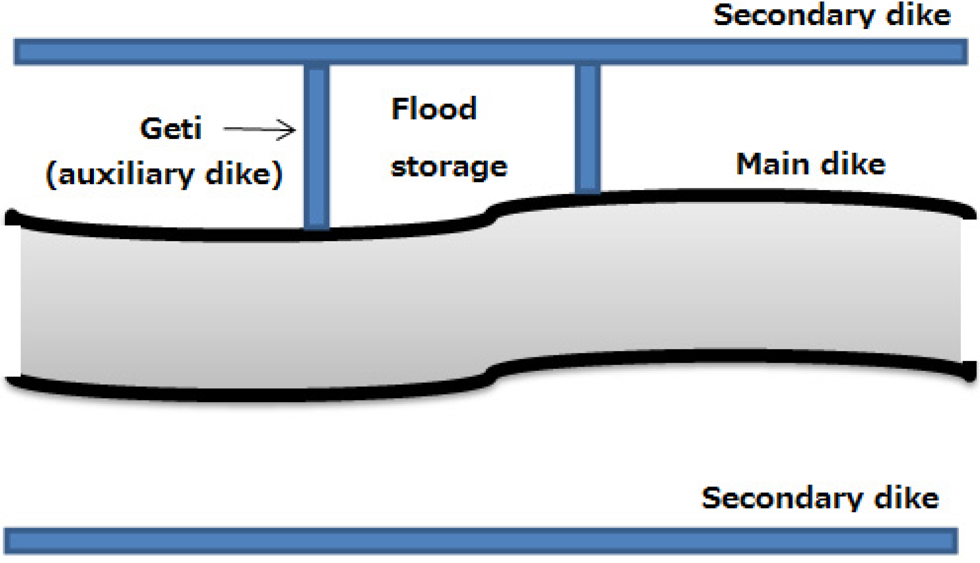
Although Jia’s proposal was well-elucidated, the least-recommended measure was adopted to curb floods of the Yellow River, rather than the best measure. Nevertheless, a good practice observed in subsequent levee construction along the Yellow River was the combination of a double-dike system with auxiliary dikes (called Geti in Chinese) in order to form a flood retarding area, as illustrated in Figure 1. This indicates that the importance of having floodwater storage was recognized and partially incorporated in ancient river works, although the best measure according to Jia was not directly followed.
Figure 1.
Practice of flood storage creation with levees in ancient China.

In Japan, dike management, as a public river engineering work, began in the Nara era (710 to 794). The Yoro Code, enacted in 757, stipulated a number of flood management rules [14]. Article No. 16 of the code states “A provincial governor and district commissioners must patrol dikes along major rivers, and to order people to repair any damage after harvesting rice in autumn. For dike breach, however, command urgent repair as soon as possible”. It appears that flood management in ancient Japan relied on levee construction, and possible levee failure was taken into account.
3.2. A Case of Flood Management in the Edo Era of Japan and Its Aftereffect in a Large Flood Event
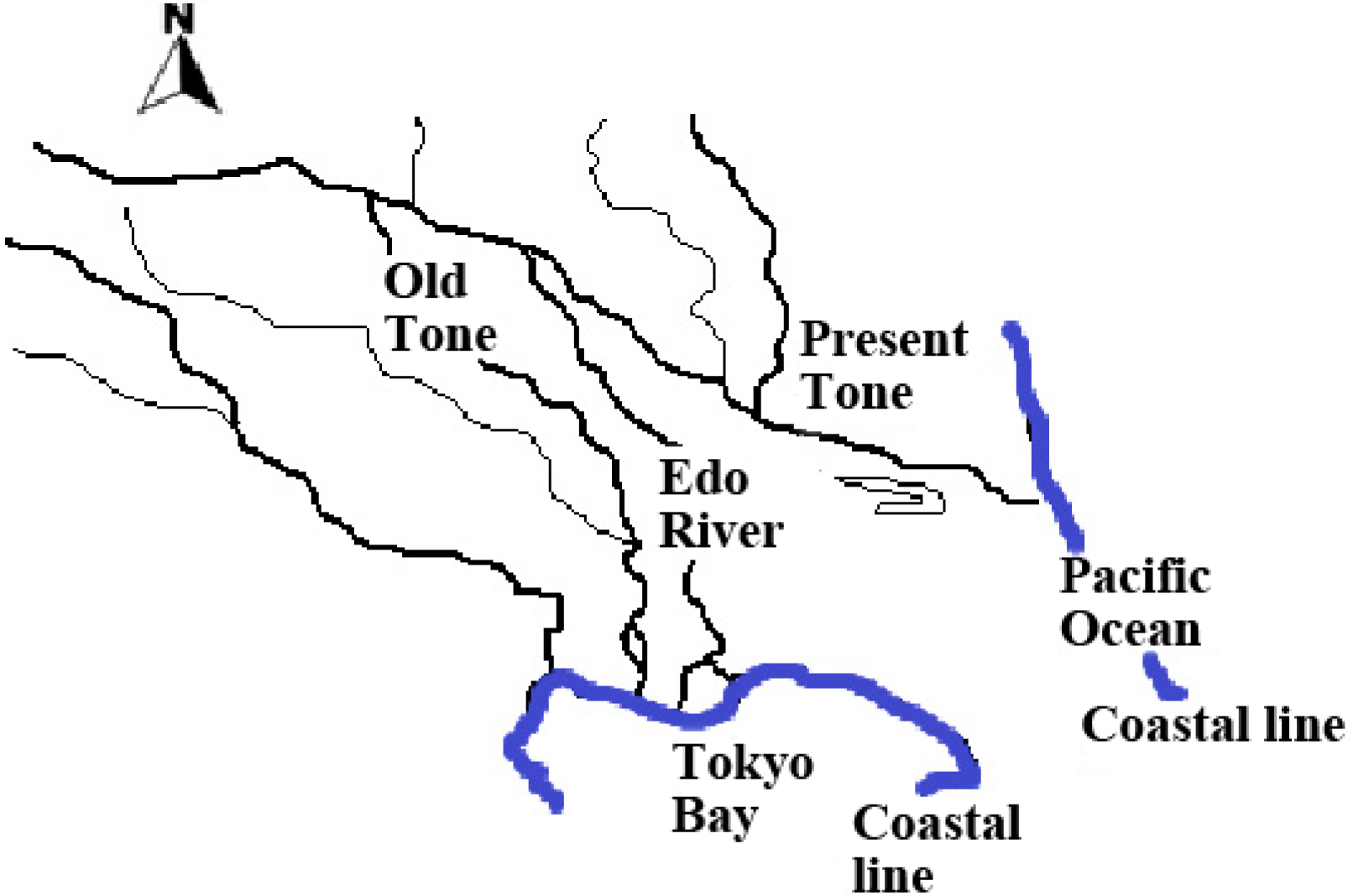
Tone River is the largest river in Japan in terms of discharge and catchment area. It is 322 km in length, flows through the Kanto region from the north to the east and enters the Pacific Ocean. However, the Tone River used to flow through the city of Edo (renamed Tokyo in 1868) and emptied into Tokyo Bay [15]. It was a violent river causing serious and frequent flood damage to surrounding areas. For flood control, farmland development and inland water transport, the Tokugawa Shogunate started the so-called eastward diversion project in 1603, which redirected the river into the Pacific Ocean (Figure 2). Following the diversion, the old flood plains were transformed to farmlands and old river reaches were used as irrigation channels. More importantly, along the new river course, large-scale farmland development was realized as a result of the new availability of water. For example, in the Sawara district, 2800 ha of paddy fields were created after the project’s initiation. Therefore, it was a multipurpose project, integrating the best and the second-best measures proposed by Jia.
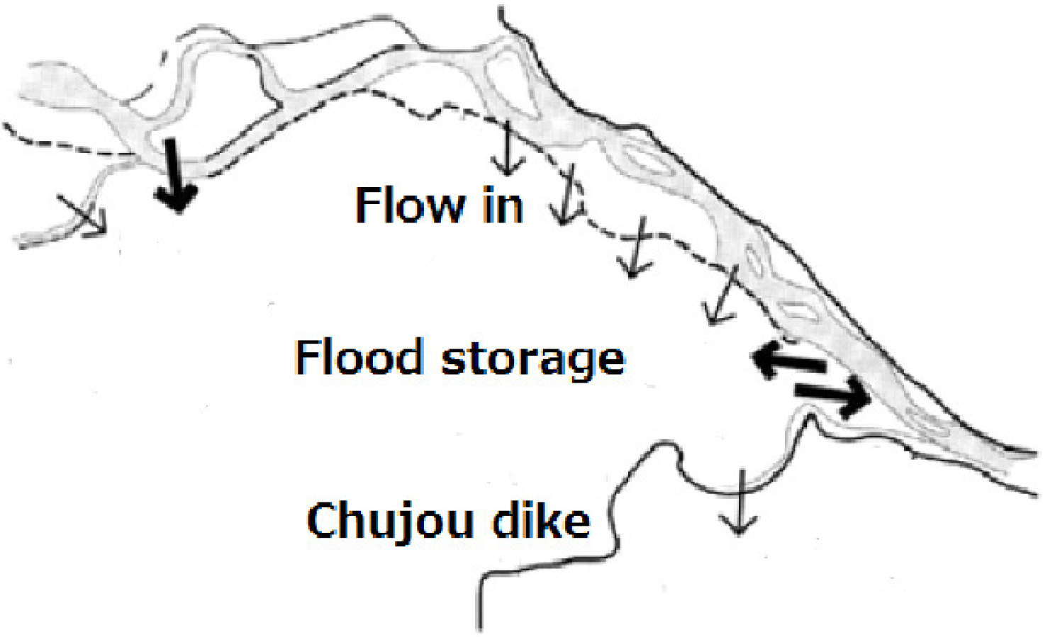
In 1947, a big typhoon named Kathleen landed in the Boso Peninsula and struck the entire Kanto Region in Japan. In the Tone River catchment, the total three-day rainfall accumulation (from 13 September to 15 September) averaged 318 mm over the basin above the Yattajima gauging site, generating the highest discharge ever recorded in Japan. Consequently, a 350-m-long levee breach occurred in the middle reach, and the floodwater coming out of the channel followed its original pathway towards Tokyo due to the natural topography, as shown in Figure 3. It inundated an area of approximately 450 km2 in Katsushika and Edo wards of Tokyo, and finally flowed into Tokyo Bay [16]. This suggests that although the multipurpose alteration of the Tone River course can be considered the realization of ancient Chinese philosophy, either coincidentally or intentionally, it had limitations and did not function well for extremely large floods. It is also worth mentioning that, similar to the Yellow River, the approach of creating a flood retarding area by constructing a levee perpendicular to the main river channel was also implemented in the Tone River during the Edo era, as illustrated in Figure 4. In 1733, the Edo government issued an ordinance stipulating that local officers should take responsibility for dike maintenance and breach prevention. This implies that the Edo government followed all three measures advocated by Jia.
Figure 2.
Eastward diversion of the Tone River.

Figure 3.
Floodwater pathways in 1947 based on historical records.

Figure 4.
Levee constructed for flood storage in the middle reaches of the Tone River in the Edo era.
Figure 4.
Levee constructed for flood storage in the middle reaches of the Tone River in the Edo era.

3.3. Contemporary Management of Flood Retarding Area in China and Japan
After World War II, flood management policy in Japan was focused on dam development in upstream reaches and levee construction in mid- and down-stream areas. Many old open levees were closed for land development and the river management was based on the premise that levees could be made fool-proof. Such a shift in the confidence of levees was due to the influence of Dutch river engineering. After the Meiji Era, Japan opened its doors to the rest of the world and actively imported modern science and technology from the West. Because of western influences, the limited availability of land and the difficulty of relocation, flood retarding basins have been used less as flood management options in contemporary Japan. Moreover, the present-day practice of the management of flood retarding or diversion areas is fundamentally different between China and Japan. In Japan, a flood retarding basin may be used as a park during normal days, but residence and agriculture inside a retarding basin are prohibited. In China, however, flood diversion areas are multipurpose. A typical example is the Jingjiang flood diversion area, which is located in the middle reach of the Yangtze River and was constructed in 1952. It is bordered on the northern and eastern sides by the Yangtze River, and on the west and south, by smaller river channels flowing from the Yangtze to Dongting Lake. It has a total area of 1358 km2, a storage capacity of 7.1 km3 and a maximum inside water level of 42 m [17].
Unlike flood retarding basins in Japan, there are 580,000 residents, 36,000 ha of farmlands, and 1852 business organizations inside the flood diversion area. The flood diversion area is indeed a multipurpose undertaking. To protect people’s lives, 21 safe polders, with a total area of 19.58 km2, and 95 high grounds were constructed inside the flood diversion area. Currently, the safe polders and high grounds accommodate 200,000 residents. The safety of the remaining 380,000 residents is guaranteed through emergency evacuation routes [18].
During July and August of 1954, the Jingjiang flood diversion area was used three times. The first time, it diverted 2.35 × 10⁹ m3 of floodwater from the Yangtze River. Three days later, it diverted 1.72 × 10⁹ m3 of floodwater. It total, it stored more than 6 × 10⁹ m3 of floodwater. An important point was that the evacuation of the flood diversion area was mandatory and resulted in an evacuation rate of 100% and zero death tolls in the diversion area in 1954. After the disaster, the government compensation totaled 8,130 million RMB for the Jingjiang flood diversion area. According to a governmental survey in 2000, the residents’ assets within the Jingjiang flood diversion area were worth 2,700 million RMB.
In 1998, another major flood occurred in the Yangtze River. Although floodwater diversion was avoided at the last minute, an evacuation of not only human but also cattle was executed. In total, 330,000 people and 18,000 cattle were mobilized [19]. The economic loss from this evacuation was reported to be 2,000 million RMB [20], but the flood diversion area received only 70 million RMB as compensation. If flood diversion had been implemented, the direct economic loss would have reached 1.50 billion RMB, due to the economic development within the flood diversion area, since the onset of the economic reform in China during the late 1970s. Nevertheless, if the Jianghan Plain downstream to the Jingjiang flood diversion area, which encompasses the large city of Wuhan, were inundated, the economic loss could be much higher than the potential loss resulting from the use of the Jingjiang flood diversion area. Therefore, in order to achieve a high benefit-cost ratio with flood diversion operations, measures such as population control, land use, and economic activity regulation inside flood diversion areas should be implemented. Furthermore, a flood insurance system should be established, and flood risk communication must be improved.
In Japan, mandatory flood evacuation has never been enforced during recent decades, which may be the cause of the low rate of flood evacuation in Japan. The evacuation rate was 13.1% during the Nagasaki flood disaster in 1982 [21]; 6.1% for the Hamada flood disaster in 1988; 51.5% for the Nasu flood disaster in 1998; 55.2% for the Mobara flood disaster in 1989 [22]; 44.5% for the Tokai flood disaster in 2000 [23]; 23.2% during the Niigata-Fukushima flood disaster in 2004 [24]; and as low as 1.6% for the Okaya flood disaster in 2006 [25]. Such low rates could neither be completely explained by low awareness or recognition of risk by the general public, nor by the lack of information communication tools for a well-developed country. This leads to the question of what political system is the best for crisis management.
According to the Flood Control Law of China, adopted by the Eighth National People’s Congress on 29 August 1997, flood-prone areas, flood storage and detention basins, and the areas protected against floods shall be delimited in regional plans for flood control and be made known to the public. A priority is to ensure the safety of vital areas, while providing a reasonable level of flood protection in other places. Similar flood management policies have been discussed in Japan but have yet to be implemented in Japanese water-related laws.
4. Concluding Remarks
The present work revealed that a large-scale river work in the Tone River of Japan, implemented during the Edo era, is highly similar in concept to the ancient Chinese philosophy of flood prevention. The rerouting of the Tone River is evaluated as an innovative realization of Jia’s flood management proposal. It has proven to be successful, but not perfect for flood management, and has brought about huge economic benefits to the region through farmland development. On the other hand, the concept of living with waters, deemed to be new in Japan, has been practiced in China for decades. Both the Tokugawa Shogunate in the Edo era and China’s political system in the 1950s can be described as authoritarian. Both the eastward diversion and the Jingjiang flood diversion projects were designed and completed without public participation. This top-down approach produced long-lasting positive effects in both societies. Nowadays, however, there is evidence that flood evacuation cannot be effectively implemented in a democratic system. Such a contrast is worthy of further in-depth research.
It is worth mentioning that until recently, the flood management policy in the EU could be characterized as a flood defense regime with a sectoral and technological focus, rather than an integral and spatial focus. After experiencing two “wake-up” floods in 1993 and 1995, when the river levels of the Meuse and Rhine almost caused dike failures, the EU has undergone policy shifts under the new EU Flood Directive, “Room for Rivers”, to accommodate floods, rather than merely protect people from floods [26]. “Room for Rivers” is also an important step toward re-establishing the ecological integrity of river ecosystems [27]. Nevertheless, the new initiative bears a high resemblance to Jia’s proposal, made more than 2000 years ago. Therefore, a comparative study between China, Japan, and the EU with regard to flood management concepts and practices is a subject worth exploring.
Acknowledgements
Appreciation is given to anonymous reviewers for their helpful comments with the manuscript.
Conflicts of Interest
The author declares no conflict of interest.
References
- Luo, C.Z. Investigation and regionalization of historical floods in China. J. Hydrol. 1987, 96, 41–51. [Google Scholar]
- Inoue, K. Flood disaster in Japan. J. Disaster Res. 2007, 3, 1–4. [Google Scholar]
- Cui, Z.P. Encyclopedia of Chinese Water; China Water & Power Press: Beijing, China, 1990; Volume 3, p. 1881. (In Chinese) [Google Scholar]
- Zhao, C.J. Prevention of Natural Disasters in Shandong Province; Qingdao Publishing House: Qingdao, China, 1992. (In Chinese) [Google Scholar]
- Li, W.H.; Zhou, Y. Disaster and Starvation (1840–1919); High Education Press: Beijing, China, 1991. (In Chinese) [Google Scholar]
- Xu, J. Historical bank-breachings of the lower Yellow River as influenced by drainage basin factors. Catena 2001, 45, 1–17. [Google Scholar] [CrossRef]
- Sutcliffe, J.V. The use of historical records in flood frequency analysis. J. Hydrol. 1987, 96, 159–171. [Google Scholar] [CrossRef]
- Shi, Y.F.; Su, B.D.; Jiang, T. Historic evolution of flood hazard in western middle reaches of the Yangtze River: human impact and current flood situation. J. Nat. Disasters 2006, 15, 1–9. (In Chinese) [Google Scholar]
- Kawasumi, T. Historical floods in Kyoto and the morphological change of its flood plains. Hist. Disaster Stud. Kyoto 2004, 1, 13–23. (In Japanese) [Google Scholar]
- Uemura, Y.; Kobayashi, Z.; Kimura, D.; Shindo, M; Yamanaka, K.; Asako, R.; Sugiyama, J.; Miyake, T.; Yamashita, H. Lowland morphology of Kizugawa River and Uji River and the disasters over the past 400 years. Hist. Disaster Stud. Kyoto 2007, 7, 1–24. (In Japanese) [Google Scholar]
- Kumaki, Y. Geographical study of the disaster in Japan. Geogr. Rev. Jpn. Ser. B 2014, 86, 132–137. [Google Scholar] [CrossRef]
- Cao, S.; Liu, X. Dujiangyan Irrigation System—A world cultural heritage corresponding to concepts of modern hydraulic science. J. Hydro-environ. Res. 2010, 4, 3–13. [Google Scholar]
- Si, M.G. West Han Dynasty. In History as a Mirror; Taiwan Commercial Press: Taibei, Taiwan, 1984; Volume 31. (In Chinese) [Google Scholar]
- Matsuki, H. Tripod scheme in flood disaster management in Japan. J. Disaster Res. 2012, 7, 582–589. [Google Scholar]
- Mushiake, K. Historical review of river improvement works in the Tone river basin. Int. J. Water Resour. Dev. 1981, 4, 58–70. [Google Scholar] [CrossRef]
- Report on 1947 Typhoon Kathleen; Cabinet Office, Government of Japan: Tokyo, Japan, 2006. (In Japanese)
- Zhang, X.L. For the Benefit of the People: Construction of Jingjiang Flood Diversion Project; Jilin Publishing Group Ltd.: Jilin, China, 2010. (In Chinese) [Google Scholar]
- Xu, Z. Construction and development of Jingjiang flood diversion area. China Water Resour. 2002, 9, 105–106. (In Chinese) [Google Scholar]
- Xiang, L.Y.; Jiang, F.R.; Ni, J.; Liu, W. Analysis of the evacuation in Jingjiang Diversion Area during the 1998 flood. J. Nat. Disasters 2000, 9, 80–85. (In Chinese) [Google Scholar]
- Wang, Y.G. 98’s Jingjiang evacuation startling the universe and moving the gods. China Econ. Trade Her. 1998, 18, 40–43. (In Chinese) [Google Scholar]
- Okabe, K.; Hiroi, O.; Mikami, S.; Yamamoto, Y.; Ikeda, K.; Miyata, K. People’s Responses during the Nagasaki Flood Disaster of 1982; The Bulletin of the Institute of Journalism; University of Tokyo: Tokyo, Japan, 1984. (In Japanese) [Google Scholar]
- Yoshii, H.; Tanaka, J. Basics for Disaster Crisis Management Theory; Koubundou Publishers Inc.: Tokyo, Japan, 2008. (In Japanese) [Google Scholar]
- Hiroi, O. Transfer of Disaster Information and People’s Responses during the Heavy Rainfall in Tokai Region in 2000; Report of Graduate School of Interdisciplinary Information Studies; University of Tokyo: Tokyo, Japan, 2008. (In Japanese) [Google Scholar]
- Hiroi, O.; Nakamura, I.; Tanaka, J. Transfer of Disaster Information and during the Heavy Rainfall in Niigata-Fukushima Region in 2004; Report of Graduate School of Interdisciplinary Information Studies; University of Tokyo: Tokyo, Japan, 2005. (In Japanese) [Google Scholar]
- Yoshii, H.; Tanaka, J.; Nanamura, I.; Fukuda, M.; Sekiya, N.; Jibiki, Y.; Morioka, C.; Chida, Y. The Problem of Information Dissemination and Inhabitant’s Behaviors in Heavy Rainfall Disaster in July 2006; Disaster-Information Management, Report of the Joint Disaster-Information Study Group between the University Tokyo and Toyo University; Joint Disaster-Information Study Group: Tokyo, Japan, 2007; p. 12. (In Japanese) [Google Scholar]
- Mostert, E.; Junier, S.J. The European flood risk directive: challenges for research. Hydrol. Earth Syst. Sci. Discuss 2009, 6, 4961–4988. [Google Scholar] [CrossRef]
- Rohde, S.; Hostmann, M.; Peter, A.; Ewald, K.C. Room for rivers: An integrative search strategy for floodplain restoration. Landsc. Urban Plan. 2006, 78, 50–70. [Google Scholar] [CrossRef]
© 2014 by the authors; licensee MDPI, Basel, Switzerland. This article is an open access article distributed under the terms and conditions of the Creative Commons Attribution license (http://creativecommons.org/licenses/by/3.0/).
Share and Cite
MDPI and ACS Style
Huang, G. A Comparative Study on Flood Management in China and Japan. Water 2014, 6, 2821-2829. https://doi.org/10.3390/w6092821
AMA Style
Huang G. A Comparative Study on Flood Management in China and Japan. Water. 2014; 6(9):2821-2829. https://doi.org/10.3390/w6092821
Chicago/Turabian StyleHuang, Guangwei. 2014. "A Comparative Study on Flood Management in China and Japan" Water 6, no. 9: 2821-2829. https://doi.org/10.3390/w6092821