Investigating the Integration of Cultural Heritage Disaster Risk Management into Urban Planning Tools. The Ravenna Case Study


1
Department of Architecture, Alma Mater Studiorum, University of Bologna, 40136 Bologna, Italy
2
CIRI Building and Construction, Alma Mater Studiorum, University of Bologna, 40136 Bologna, Italy
*
Author to whom correspondence should be addressed.
Sustainability 2021, 13(2), 872; https://doi.org/10.3390/su13020872
Submission received: 31 December 2020
/
Revised: 11 January 2021
/
Accepted: 13 January 2021
/
Published: 16 January 2021
(This article belongs to the Special Issue Natural Events Threatening the Cultural Heritage: Characterization, Prevention and Risk Management for a Sustainable Fruition)
Abstract
:As increasingly recognized by scholars, climate change is posing new challenges in the field of disaster risk management and urban planning. Even though cultural heritage has passed through decades and centuries, it has never experienced such unexpected and variable events as those forecasted by climate change for the foreseeable future, making it a sensitive element of the living environment. By selecting the city of Ravenna and the cultural heritage site of the Santa Croce Church and archaeological area as a case study, the paper aims at providing an insight into the role that urban planning tools have when it comes to improving the resilience of historical areas, coping with climate change through improvements to the disaster risk management of cultural heritage. Starting from a deep analysis of the existing spatial and urban planning tools that operate at different scales on the Ravenna territory, the adaptive capacity of the historical area toward the identified risks was assessed. The results may lead, on the one hand, to improving the integration of cultural heritage risk management into urban planning tools; on the other hand, they contribute to improving the scope and the governance of the heritage management plans in order to cope with climate change risks and their effects.
1. Introduction
Cultural heritage, which has been skillfully handed down to us through the centuries, today is dealing with an unprecedented and constantly changing climate [1,2,3,4,5]. Its effects are making the protection, management, and use of cultural heritage more challenging [6,7,8,9]. Current disaster statistics do not consider cultural heritage as a sensitive and resilient element of the living environment [10]. Furthermore, policies to protect heritage from natural and anthropic risks remain fragmented, while the importance of learning from traditional best practices and knowledge for building resilience appears underestimated [11].
The opportunity to use cultural heritage and its inherent value, the importance of raising awareness of climate change, and the potential effect it would generate if considered together with existing risks have all been underlined by the UNESCO World Heritage Centre and its advisory bodies [7,8,12]. Nevertheless, due to the uncertainty of climate change and the quite static concept of cultural heritage rooted in the World Heritage Convention [11], there is still a lack of a globally comprehensive and shared framework able to provide effective and standardized guidelines to deal with the integration of these themes [13,14].
Despite increasingly recognizing that risks can no longer be assessed without considering climate change, their assessment turns out to be more difficult and the adoption of a holistic approach necessary [15,16,17,18,19,20,21,22,23,24]. This leads to a greater emphasis on the preventive phase of risk management [9,25,26,27,28], consisting of the definition of mitigation strategies and the drafting of emergency plans to deal with potentially dangerous situations [29]. According to the latest report of the Intergovernmental Panel on Climate Change (IPCC) [30], the paramount cause of climate change is attributed to human action, which has led to an exponential growth in greenhouse gas emissions. The main expected changes resulting from climate change are increased global mean temperatures and global sea level, increased intensity of rainfall events, but at the same time, more frequent droughts in arid and semi-arid areas and increased frequency of storms locally. The projected scenarios do not affect the ecosystem functioning only, but also the global socioeconomic equilibrium [31]. The complexity of the climate change phenomenon, whose causes can be found in many sectors of our living routine, together with the existing risks that affect a specific territory, is underlining the urgency of adopting coordinated policies and plans based on long-term planning and decision-making scenarios [32].
Recently, the UNESCO World Heritage Centre and its advisory bodies have started to delineate strategies to assist state parties to implement management plans in response to the possible effects of climate change on cultural heritage. They call for reducing non-climatic stress factors on cultural heritage sites to enhance their resilience to climate change impacts; identifying and promoting synergies between adaptation and mitigation actions; conducting climate change vulnerability analysis, risk assessment, and developing appropriate management plans; collecting and documenting information on the impacts of the past and current climate change on World Heritage sites [33]; emphasizing the key role of cultural heritage in raising awareness of the effects of climate change, thus supporting actions to tackle it [7].
As highlighted above, human actions being the main cause of climate change, the key role that spatial and urban planning can play in opposing it is increasingly recognized [34,35,36,37,38,39,40]. Indeed, urban planning tools dealing with the built environment transformations can have a key role in integrating the disaster risk management of cultural heritage into a holistic and comprehensive approach to increasing resilience in cities through adaptation and mitigation measures, to further limit situations of danger and disasters [41,42,43,44,45,46,47,48,49].
Climate change influences disaster risk management of cultural heritage by modifying climatic and non-climatic factors that contribute to the vulnerability assessment of cultural assets [7,50,51]. The concept of vulnerability has been defined for long time as the interaction of both sensitivity (i.e., the degree to which a system is affected, either adversely or beneficially, by hazards or climate-related stimuli) and exposure (i.e., the nature and degree to which a system is exposed to significant hazards or climatic variations) [52,53,54,55,56,57]. However, in the last few years, an updated vulnerability assessment definition has been proposed which also includes adapting the capacity of policies, environments, and society to the hazards. The cross-nature concept of adaptive capacity, which may be defined as the ability of a system to modify its behavior to cope better with changes of its living environment, stresses the shifting philosophy from potential to feasible adaptation [58].
In this framework, the overall aim of the paper is to provide insights into the role of urban planning tools for improving historical area resilience to climate change through improvements to the disaster risk management of cultural heritage. To this aim, the city of Ravenna (Figure 1) was considered as a case study, with a focus on the Santa Croce Church and its archaeological area (Figure 2), located in the heart of the city center, next to two out of eight UNESCO World Heritage monuments that are present in this city. On the one hand, the research investigates to what extent the integration of cultural heritage, disaster risk management, and climate change has been already addressed by Ravenna urban planning tools; on the other hand, the paper assesses the adaptive capacity of the most relevant planning tools toward the risks identified as more significant.
The case study is part of the H2020 Shelter project (GA No. 821282), which aims at promoting and enhancing a dynamic view based on a resilience thinking where risks and uncertainty are used to define sustainable strategies. For the Ravenna case study, the Shelter project has identified three main hazards toward which research should be directed (i.e., earthquake, subsidence, and flooding) and climate change as the amplifying phenomenon of these existing risks. Therefore, the aim of this research is to consider earthquake, subsidence, flooding, and climate change when the disaster risk management of cultural heritage is investigated. Despite Ravenna belonging to a medium–low seismic risk zone [59], the church could be subject to serious damage in the case of a seismic event, due to several architectural interventions that modify the original structure, affecting, in turn, the structural stability [60]. The subsidence phenomenon, which causes vertical ground lowering, has characterized the area of Ravenna for over a century [61,62,63,64]. The progressive sinking of the soil, together with the aquifer proximity to the ground, entails a high hydrogeological natural risk for Santa Croce and the surrounding monuments, consequently placing the assets also at a flooding risk [65]. At present, the level of water is managed only with manually controlled pumps with no early warning system active in the area, a situation that can hinder an immediate response when anomalous situations occur [60].
The paper is organized into six sections. Following this introduction, Section 2 focuses on the concept of adaptive capacity where a literature review is conducted to both frame the concept and investigate it in relation to spatial planning instruments. Section 3, Materials and Methods, provides, at first, an insight into the Italian urban planning framework and the Ravenna planning tools to contextualize the case study (Section 3.1); then it describes the process that led to the definition of the most relevant planning tools for the city of Ravenna, as far as disaster risk management, cultural heritage and climate change are concerned (Section 3.2), and the methodology applied to assess the adaptive capacity of the case study based on the selected planning tools (Section 3.3). Section 4, Results, presents the four planning tools selected for defining a more complete framework for integrating cultural heritage risk management into urban planning and enhancing strategies for increasing the resilience of the case study historical center (Section 4.1). Moreover, Section 4.2 explains to what extent the existing planning tools contribute to the adaptive capacity of the Ravenna historical center toward risks and their management. Section 5 includes the discussion of the results and proposes a brand-new cultural heritage risk management protocol aiming at enhancing resilience through governance. Lastly, Section 6, Conclusion, summarizes the objectives achieved and highlights new challenges and threads for future applications underlying the need of considering cultural heritage as a sensible and resilient element of our living environment.
2. Focusing on Adaptive Capacity
Adaptive capacity was defined by the last IPCC report concerning climate change as “the ability of systems, institutions, humans and other organisms to adjust to potential damage, to take advantage of opportunities, or to respond to consequences” [30]. Adaptive capacity is strictly linked to vulnerability, as the latter encompasses a variety of concepts and elements, including sensitivity or exposure to harm and lack of capacity to cope and adapt. The concepts of exposure and sensitivity proportionally depend on and influence vulnerability, while adaptive capacity affects the latter in an inversely proportional way. The existing literature has argued considerably on the choice of the relevant fields or dimensions that should be considered for assessing adaptive capacity, as it is a complex concept that embraces environmental, economic, socio-cultural, and technological characteristics [66,67].
According to Holling [68], the concept of adaptive capacity has been influenced by work done in the area of social–ecological systems and it is linked more with the definition of governance than of government: the latter is conceived as a strict, centralized, top-down process whose main task is to provide rules of public interest to be implemented at local level. In contrast, governance is seen as a flexible, diffuse, bottom-up and top-down process. As a consequence, it allows for strong interaction, both between social actors with very different interests and between different levels of government. In fact, according to Gupta et al. [66], the concept of adaptive capacity is strictly linked to institutions and their ability to embed multiple frames of references, problem definitions, and options that involve different actors in the governance process [32].
When it comes to assessing institutional adaptive capacity, scholars [66,69,70,71,72,73] have highlighted a number of indicators: variety, by dealing with cross-scale dynamics, matching scales and sectors of ecosystems and governance, and accounting for external drivers; learning capacity, by sustaining social memory and enhancing socio-ecological memory; room for autonomous change, by increasing the capacity of individuals to self-organize and innovate; leadership, by its capacity of sharing information on possible adaptation strategies; resources; fair governance; nurturing diversity for reorganization and renewal; the availability of a plan that is adaptive, forward thinking, and addresses different risks; infrastructures; social capital; access to risk spreading processes; education.
In addition, Bossio et al. defined the interlinked dimensions of processes and institutions as relevant factors that shape adaptive capacity. Processes are distinguished between multi-level and place-based ones. On the one hand, processes occurring at the global level—such as globalization, trade agreements and urbanization—or at the national level—such as authority decentralization—shape actors’ ability to deal with their changing living environment. On the contrary, economic, political, social, ecological place-based processes influence the vulnerability—through adaptive capacity—of a particular place and actors’ responses to and preparedness for hazards. On the other hand, institutions are considered the determinants concerning the formal and informal norms that emerge from social interaction and guide actors’ behavior [74]. Therefore, institutions can positively or negatively influence their own adaptive capacity.
Polsky, Neff and Yarnal [75] defined the dimensions for assessing adaptive capacity in a context more related to disaster risk management: access to technology, management structure, and access to information. The more they are explored, treated, and specified by the institution dealing with risk management, the more likely adaptive capacity will be high and, consequently, vulnerability will decrease.
As vulnerability assessment, adaptive capacity assessment depends on the specific characteristics of each analyzed and studied case. It is worth highlighting that, when it comes to planning tools and their scope—which varies from land use regulation, sustainable mobility, environmental quality and safeguarding, social and economic sustainable development—adaptive capacity might be intended, according to the dimensions given by Gupta et al. in [66], to describe institutional adaptive capacity. On the contrary, when focusing on cultural heritage and its management, the key features of adaptive capacity appear as those identified by Polsky, Neff and Yarnal in [75]. Because the aim of this research is to identify the capability of urban planning tools to cope with the changing environment—with a particular attention to historical areas and cultural heritage being protected as the symbol and core of our cities and communities—both the ability of institutions to have a long-term vision involving different actors and sectors and the ability to proactively cope with natural and man-made risks should be taken into account. For this reason, the spatial and urban planning dimension of adaptive capacity in the Ravenna case study was investigated.
3. Materials and Methods
3.1. An Insight into the Italian Spatial Planning Framework and Ravenna Urban Planning Tools
Across Europe, the competences for spatial planning lie on a national, regional/county, or local level. Indeed, the European Union itself has no general competence assigned within this field. However, even though the EU has no explicit competence in spatial planning, existing EU sectoral competencies and activities influence spatial planning instruments and spatial developments indirectly [76].
Moving to Italy, it should be noted that the Italian urban planning system provides for a hierarchical organization in which local plans have to take into account the prescriptions of the higher-level plans. The main national law about urban planning dates back to 1942 (Law No. 1150, dated 17 August 1942). Starting from the 1970s, the legislative authority in the field of urban planning has been gradually delegated to the regions. The lack of an up-to-date national planning framework has led to an intense production of regional laws concerning urban planning and, consequently, to a heterogeneous scenario all over the peninsula, characterized by different regulation of urban planning at local levels [77].
Regarding to the national planning level, the National Adaptation Plan to Climate Change (PNACC—Piano Nazionale di Adattamento ai Cambiamenti Climatici) [78] was considered in this research as it constitutes the main national reference to deal with climate change. Moreover, the Flood Risk Management Plan (PGRA—Piano di Gestione Rischio Alluvioni) [79] was considered, since it constitutes the most relevant instrument to assess, manage, and monitor flood risk. The monitoring strategies, the obtained data describing maps, and the regulations about managing flood risk contained in this planning instrument must be observed by lower-level spatial planning tools. It was drawn by the River District Basin Authority, a joint body that does not correspond to any administrative level, but its level of competences can be described as intermediate between national and regional. The body dealing with the Ravenna Municipality area is the Po River District Basin Authority.
Within the scope of this research, the spatial planning regulatory framework taken as a reference was that of the Emilia-Romagna Region, where the city of Ravenna is located. The Emilia-Romagna Region applies the horizontal subsidiarity, meaning that decisions should be taken at the closest level to the citizens, and what can be achieved by local authorities does not need to be done by higher-level institutions. The Regional Spatial Plan (PTR—Piano Territoriale Regionale) [80] is the strategic and programming tool to ensure sustainable development, social cohesion, and competitiveness of the regional system. It outlines general development strategies to be subsequently specified by administrative bodies at lower levels of the spatial planning hierarchy. With reference to landscape and heritage protection, the regions are required to draw up their own Regional Landscape Protection Plan (PTPR—Piano Territoriale Paesaggistico Regionale) [81]. It is superordinate to all the other lower levels of urban planning, thus emphasizing the key role of both landscape and cultural heritage preservation in managing territorial transformation [82]. Furthermore, it identifies and quantitatively describes the main anthropic and natural hazards. The Regional Landscape Protection Plan of the Emilia-Romagna Region dates back to 1988. In addition to the regional-level spatial planning instruments just mentioned, other sectoral planning tools were taken into account as their contents are related to the main themes covered by this paper: the Emilia-Romagna Region Mitigation and Adaptation Strategy for Climate Change (SMACCER—Strategia di Mitigazione e Adattamento ai Cambiamenti Climatici della Regione Emilia-Romagna) [83], the Integrated Regional Transportation Plan (PRIT—Piano Regionale Integrato dei Trasporti) [84], the Integrated Regional Air Plan (PAIR—Piano Aria Integrato Regionale) [85], the Water Protection Plan (PTA—Piano di Tutela delle Acque) [86].
It is necessary to note that, although the legislative and administrative power of the Italian Provinces is in the process of being abolished due to Law no. 56, dated 7 April 2014, the Provincial Spatial Plan (PTCP—Piano Territoriale di Coordinamento Provinciale) [87], which constitutes the link between the regional planning tool and the municipal one, is still in force. Referring to the provincial-level spatial planning, the Provincial Emergency Plan (PPE—Piano Provinciale di Emergenza) [88] was also considered due to its relationship with the field of disaster risk management.
Italian urban planning is mainly regulated at the municipal level. Referring to the Ravenna context, the current urban plan is structured into three documents: the Structural Urban Plan (PSC—Piano Strutturale Comunale) [89], which is a long-term, non-prescriptive plan and sets out the strategic guidelines for territorial governance deriving from higher levels; the Operating Plan (POC—Piano Operativo Comunale) [90], which is a working, programming, and prescriptive plan with a limited duration in time; and lastly, the Urban Building Regulations (RUE—Regolamento Urbanistico Edilizio) [91]. However, according to the latest Emilia-Romagna Regional Law no. 24 of 2017 on spatial planning, all the municipalities are expected to adopt a new urban plan named Urban General Plan (PUG—Piano Urbanistico Generale) [92] by the end of 2022. Therefore, the Ravenna Municipality finds itself in a transition phase, where the preliminary strategic guidelines of the new urban plan have been drafted, but not adopted yet. For this reason, the research has considered both the current urban plan, as well as the baseline framework and strategic guidelines of the new coming one (PUG).
As this paper aims at investigating the integration of cultural heritage and disaster risk management into urban planning tools, additional sectoral planning tools were considered, such as the Management Plan of the UNESCO Early Christian Monuments serial site in Ravenna (PdG—Piano di Gestione dei monumenti paleocristiani di Ravenna patrimonio dell’umanità) [93] and the Municipal Civil Protection Plan (PPCC—Piano di Protezione Civile Comunale) [94]. Furthermore, since the Sustainable Energy Action Plan (PAES—Piano di Azione per l’Energia Sostenibile) [95] and the new Sustainable Energy and Climate Action Plan (PAESC—Piano di Azione per l’Energia Sostenibile e il Clima) [96] constitute the main municipal-level references to sustainable spatial development and adaptation to climate change, their contents have been analyzed, too. In addition to the just mentioned planning tools, the Sustainable Urban Mobility Plan (PUMS—Piano Urbano di Mobilità Sostenibile) [97] and the Action Plan for the Ravenna Building Asset (PdA—Piano di Azione per l’Agglomerato di Ravenna) [98] were also considered.
3.2. Methodology for Identifying the Most Relevant Planning Tools
A four-step selection process (Figure 3) was implemented, aiming at recognizing the most relevant planning tools in terms of their capacity to plan in a proactive way to respond to the consequences of disasters in the Ravenna case study. Indeed, identifying the planning tools responsible for framing actions to influence the potential damage caused by the identified risks to the historical city and Ravenna cultural heritage can be considered the first step for improving the integration of cultural heritage disaster risk management into urban planning.
At first, the recognition of the planning tools acting either at municipal level or at supra-municipal one was performed. They referred to wider fields of cultural heritage preservation and valorization, sustainability, and environmental quality, acting both at municipal level and at higher administrative level. The aim of the first step was to embrace the main investigation topics of this research—cultural heritage, risk management, and climate change—in the widest way possible while searching for the planning instruments embedding actions to address the identified hazards. They all were applied as inputs for the selection process.
Secondly, to establish and define whether a planning tool could influence the case study adaptive capacity towards the identified risks, standardized analysis sheets were used. Information on the following items was collected: (a) plan name; (b) plan type; (c) plan level; (d) main topics addressed; (e) source (i.e., which law or directive produced the plan); (f) date of adoption; (g) date of approval; (h) objectives; (i) territorial entities involved in the drafting process (i.e., which entities, in addition to the responsible one, were involved in drafting the plan); (j) documents of the plan; (k) territorial entities involved in the implementation phase (i.e., which entities, in addition to the responsible one, were involved in the implementation of the plan); (l) digital instruments applied (i.e., whether particular technologies were used to draw up the plan or parts of it); (m) plans that must follow its guidelines; (n) supra-municipal planning; (o) articles directly relevant to the area of interest; (p) additional notes and comments. The analysis sheets produced constituted the state of the art in terms of existing planning and regulatory tools that act on the Ravenna territory, considering all the governance levels (i.e., river basin, regional, provincial, and municipal).
After the first and second steps, the extent to which planning tools in force for the city of Ravenna take into account cultural heritage, risk management, and climate change was investigated. Through this assessment, planning tools dealing specifically with the three topics were identified. This third step led to discarding the planning tools dealing with sectoral topics other than cultural heritage and disaster risk management, although related to sustainable development.
Lastly, for the planning tools that passed only the third step, strengths and weaknesses were highlighted. The presence of a governance level closer to the local one—meant to have a great specification of data and information—the availability of a monitoring program for assessing the effectiveness of a plan; the involvement of other entities or bodies in the implementation of a plan; the consideration of climate change as an amplifying factor of the existing risks; the presence of an abacus of strategies, measures, or actions to adapt to hazards; education and formation as means of raising awareness; and the integrated dimensions of risks were considered strengths. The absence of the abovementioned elements constituted a weakness.
3.3. Investigating Adaptive Capacity through Planning
The assessment of the plan’s adaptive capacity was consequential to the selection of the planning tools, as the former operationalizes the knowledge resulting from the analysis of the latter.
For each hazard identified as relevant to the Ravenna case study, an attempt was made to identify within the planning tools: (1) the presence (or absence) of maps describing these risks in terms of intensity and frequency; (2) the presence (or absence) of adaptation and mitigation strategies and, whenever possible, the definition of prescriptive articles limiting their causes; (3) the presence (or absence) of monitoring strategies toward disaster risk management. The desired information was investigated in the form of guiding questions. The identification of the guiding questions did not aim at being exhaustive, also considering the limited number of risks that were taken into account as relevant for the Ravenna case study, compared to those that could characterize a given territory. Nevertheless, they allowed to highlight the main characteristics and limitations of the planning instruments when it came to influence their adaptive capacity of a given territory.
The first planning level that was investigated for the presence of this desired information was the municipal one, being the one with the highest degree of detail. The adaptation capacity at local level was considered as positively influenced whenever a planning tool included elements to support cultural heritage disaster risk management. In case this information was not present at the municipal level, its closest supra-municipal planning level was analyzed. In the specific case of the Ravenna case study, the analysis was carried out referring to two-time scenarios: “nowadays” and “future strategies.” This differentiation was due to the fact that the current legislation in the Emilia-Romagna Region requires all municipalities to adopt a new urban plan by 2022, to replace the existing one.
4. Results
4.1. The Planning Tools
The recognition phase led to the individuation of 20 planning tools (briefly described in Section 3.1) regarding the Ravenna territory and differing in governance scale and thematic threats (Figure 4). According to the methodology described in Section 3.2, by applying the inputs of cultural heritage, risk management, and climate change, the selection was refined from 20 to 11 planning tools (i.e., the ones highlighted with dotted squares in Figure 4). For each of these 11 planning tools, strengths and weaknesses were highlighted. An exception was made for the new urban plan (PUG), where an attempt was made to identify the strengths only, based on the baseline framework and strategic guidelines already available for the new upcoming Ravenna urban plan. Indeed, it was not possible to specify its weaknesses, due to the lack of details of the strategic guidelines that will lead to the drawing of the complete municipal urban plan in the coming months.
From the analysis of the strengths and weaknesses (Table 1), four planning tools resulted as being the most relevant in tackling cultural heritage, risk management, and climate change: the new urban plan (PUG—Piano Urbanistico Generale); the Management Plan of the UNESCO Early Christian Monuments serial site in Ravenna (PdG—Piano di Gestione dei monumenti paleocristiani di Ravenna patrimonio dell’umanità); the Sustainable Energy and Climate Action Plan (PAESC—Piano di Azione per l’Energia Sostenibile e il Clima); and, lastly, the Municipal Civil Protection Plan (PPCC—Piano di Protezione Civile Comunale). It should be noted that all the planning tools identified as relevant referred to the municipal level, thus confirming the key role of this governance level in an integrated risk management.
The new urban plan (PUG) is the policy instrument through which the Municipality of Ravenna individuates both its strategy and rules for the city transformation in the long term. It regulates the whole municipal territory, and its content is mainly oriented to discipline the regeneration processes of the existing urbanized territory, defining an approach based on environmental and urban quality. As far as the provisional documents available allowed to understand, the new urban plan (PUG) is expected to take into account the future territorial risks and fragility, its competitive opportunities, and its economic and environmental potential in a more systematic way than was done by the current urban plan. This increase in the available knowledge will be possible through the development of guidelines, rules, programs, and projects capable of pursuing growing and necessary integrations of actions [92]. Lastly, it should be highlighted that in the Strategic Environmental Assessment of the urban plan—whose contents and objectives are defined by the Emilia-Romagna Regional Law no. 24/2017—climate change is not addressed.
The Management Plan of the UNESCO Early Christian Monuments serial site in Ravenna (PdG) is the municipal-level planning instrument through which the eight buildings, part of the UNESCO site called “Early Christian Monuments of Ravenna,” are enhanced, protected, and preserved. The general objective of the Management Plan is to formulate new strategic priorities to safeguard and manage the Ravenna UNESCO site, considering the evolution of the context and the upcoming challenges. This plan individuates five relevant and strategic dimensions—knowledge, protection and conservation, enhancement, communication, and, lastly, sustainability—to be followed and implemented to better manage the asset of Ravenna [93]. Although throughout the plan much importance is given to the monitoring of UNESCO assets, the PdG appears to be a policy instrument aimed at the economic promotion and attractiveness of cultural heritage, while it lacks measures to tackle existing and future risks. Therefore, this had to be highlighted as a shortcoming.
The Sustainable Energy and Climate Action Plan (PAESC) is a sectoral planning tool, drawn up at municipal level, aiming at defining adaptation actions to make the territory and its landscape resilient to the existing natural and anthropic risks amplified by climate change. In doing so, the hazards to which the territory is subject—mostly of a hydrogeological nature, such as hydraulic risk, subside, salt wedge—are analyzed, relating them to the future effects of climate change and processes of transformation already underway in the territorial context. Therefore, medium-term (year 2050) strategic intervention scenarios were outlined to advance possible structural responses to the need of adapting the territory to future forecasts that take into account both the existing risks and the effects of climate change [96]. Even though this instrument poses valid strategic adaptation measures, there were two deficiencies that needed to be brought to attention: on the one hand, the Ravenna historical center is not considered as a sensitive and capable-to-adapt element; on the other hand, this policy instrument neither allocates funding to make its strategies effective, nor is integrated with the new urban plan provisions, resulting in a sectoral plan containing extremely relevant actions, however difficult to be implemented in practice.
The Municipal Civil Protection Plan (PPCC) is a tool at municipal level whose task is to organize resources according to prevention plans to cope with the specific risks of the territory. Civil Protection activities include risk forecasting, prevention and mitigation, as well as disaster management and post-emergency recovery operations. The Ravenna PPCC is based on an in-depth analysis of the types of risk that may affect the territory and, above all, of the possible risk scenarios that may arise for each type of natural and/or anthropic disaster event. For each of the identified risk scenarios—which should take into account the evolution of spatial planning and territorial climate-driven changes, too—this instrument establishes unambiguously and without any doubt what actions are to be taken, who must take them and in what way, and how many people and which structures and services will be involved and/or damaged, and, lastly, what resources are available to deal with the event. The list of actions to be taken refer to the emergency phase without considering long-term prevention strategies [94].
4.2. The Planning Tool Dimension of the Adaptive Capacity toward Disaster Risk Management
The “nowadays” scenarios resulting from the adaptive capacity assessment based on current planning tools in relation to the identified risks (i.e., seismic risk, flood risk, subsidence, and climate change) are shown in Table 2, where answers to the desired information outlined in Section 3.3 are provided.
While maps describing the intensity and frequency of earthquake and subsidence phenomena are present in the spatial and urban planning management instruments at municipal level, thus underlying the fact that these risks are considered relevant to the effective spatial development of this territory, flooding and climate change quantitative description through maps appears only at provincial and regional levels. This implied a lower characterization of the hazards.
Whether an area was subject to high, medium, or low seismic risk, adaptation strategies toward seismic risk were not treated at any level of spatial planning, confirming the fact that in Italy it is still challenging to approach and manage seismic risk in a preventive manner. In fact, the incentives framework to improve the seismic response of buildings may have a limited impact on the risk exposure without the definition of a program for reducing urban seismic vulnerability—whose basic principles are the definition of the Minimum Urban Structure and the Emergency Limit Condition [99]. Whereas strategies to deal with the adaptation to and reduction of flood risk, subsidence, and climate change could be found in planning instruments at the supra-municipal level. Similar conclusions could be made referring to the issue of monitoring programs. With reference to seismic risk, no planning tools outline a monitoring program to control the changes over time and the effectiveness of the identified measures, while some supra-municipal planning instruments propose monitoring programs toward flooding, subsidence and climate change.
Table 3 shows the results of the “future strategies” scenarios, where the new urban plan was questioned about the presence of the three desired pieces of information outlined in Section 3.3, to understand its contribution to adaptive capacity for the case study.
Although provisional documents only were available at this stage for the new urban planning tool, the strategies envisaged by the PUG seem to go in the direction of a strong consideration of the dimension linked to proactive risk management, proposing adaptation and mitigation strategies of the risks that are most relevant to the Ravenna context. In particular, the baseline framework at the basis of the new urban plan includes descriptive maps referring not only to earthquake, flooding, and subsidence, but also to the future effects of climate change, thus highlighting the growing importance and awareness on this issue, which represents one of the major challenges of our time. Another result that should be brought to attention concerns the prevalence of adaptation strategies over mitigation ones, as the measures and monitoring framework acknowledge the need of coping with the risk instead of aiming at removing it.
Seismic risk, through the definition of a Minimum Urban Structure (SUM), is considered in its urban dimension, acknowledging the mutual relationships between the existing buildings and open spaces, thus overcoming the previous reductive approach based only on the characterization of the single building. With regard to flood risk, future strategies present an innovative approach aimed no longer at implementing “grey” infrastructures (i.e., artificial water basins), but at implementing “green” adaptation and mitigation measures, to make the territory more resilient. In fact, adaptation measures to flood risk include the de-sealing and de-paving of existing areas, whereas for new developments high levels of permeability are imposed. Subsidence is the only phenomenon that was linked to cultural heritage by providing interventions to safeguard and securing historical assets.
The adaptation and mitigation measures defined to cope with climate change acknowledge human action as the primary cause of this phenomenon. However, a sectoral approach to climate change effects is still in place, with a lack of collaborative strategies toward common targets between the different economic sectors. Although a certain importance is given to the implementation of adaptation and mitigation strategies and measures, the enhancement of cultural heritage resilience remains in the background.
5. Discussion
On the one hand, although the results obtained from the assessment of the planning instrument dimension of the adaptive capacity (Table 2) did not provide an exhaustive overview of Ravenna adaptive capacity based on the current urban plan, as economic, social, political, and technological aspects should also be taken into account in its formulation, they helped to identify gaps in risk management within current planning tools. On the other hand, the analyzed future strategies (Table 3) set out future paths by listing actions aimed at increasing the resilience of the historical center of Ravenna. The possibility of analyzing the transition from one urban plan to another—as it happens for this case study—can help to understand where, when, and how disaster risk management can be more effectively included in new planning instruments, especially when it comes to the protection of the historical center and of cultural heritage. Moreover, if strategies set by planning tools involve the collaboration and cooperation with other institutional bodies, the adaptive capacity assessment may serve as the moment of validation that this collaboration has taken place.
The transition phase from the current urban plan to a new one (PUG) resulted in a key moment for assessing the strengths and weaknesses of the urban planning tools and providing inputs to the new municipal planning tool, in a circular way. Indeed, the current urban plan contributed to the assessment of the current planning tool dimension of adaptive capacity toward the identified risks, while the new urban plan was selected—together with three other sectoral planning instruments—to accommodate the proposal to enhance resilience through governance (see Section 5.1). Considering the new urban plan and its strategies only as a contribution to the analyzed adaptive capacity would have constituted a shortcoming for this research, since, nowadays, the implementation part of this planning tool is missing. Instead, considering the current urban plan as the municipal instrument for suggesting improvements to the Ravenna urban planning framework would have meant negating the effort by involving an instrument that in the near future will no longer exist.
The planning tool selection process identified four planning tools that, for the issues raised and the level of governance considered and managed, can “work together” to define a more complete framework for integrating cultural heritage risk management into urban planning and enhancing strategies to increase the resilience of the Ravenna historical center. The possibility of collaboration and sharing information and data already contained in other planning tools, highlights that there is no need to create brand-new planning tools for achieving the integration of cultural heritage and risk management into urban planning tools.
In fact, by coupling the four planning tools identified as relevant to managing the interlinked main themes of this research, and the adaptive capacity assessment referring to the case study, it was sufficient to define a strategic proposal—a six-phase cultural heritage risk management protocol—to be integrated in the existing planning tools. Among the four planning tools selected as relevant to the cultural heritage risk management protocol proposal, the new urban plan (PUG—Piano Urbanistico Generale), and the Management Plan of the UNESCO Early Christian Monuments serial site in Ravenna (PdG—Piano di Gestione dei monumenti paleocristiani di Ravenna patrimonio dell’umanità) were identified as those more relevant for integrating climate change and disaster risk management into heritage management for enhancing the resilience of historical areas. Conversely, the Sustainable Energy and Climate Action Plan (PAESC—Piano di Azione per l’Energia Sostenibile e il Clima), and the Municipal Civil Protection Plan (PPCC—Piano di Protezione Civile Comunale) were identified as knowledge and programmatic tools, carrying out a function of collaboration toward the first two plans. As a consequence, the PdG should be the one to include a strategic approach for the management of the UNESCO site against the identified risks, which is hereafter described as a six-phase cultural heritage risk management protocol (Section 5.1). Concerning the other three policy instruments, the PUG should, firstly, include the mitigation and adaptation strategies (e.g., nature-based solutions to increase the permeability of the soil and support the natural water cycle, de-sealing and de-paving actions that can also give requalified public spaces back to the community) aimed at increasing the resilience of the historical center of Ravenna, as previously mentioned; secondly, the Strategic Environmental Assessment should be rethought to embed climate change into the urban planning process to avoid underestimating the consequences of urban transformations, coherent with the guidance on Strategic Environmental Assessment provided by the European Commission [100]. Moreover, the PAESC supports the first two plans regarding the phenomenon of climate change and the relationship between it and the risks of the Ravenna area, while the PPCC supports them regarding the state of emergency managing.
5.1. Enhancing Resilience through Governance: The Cultural Heritage Risk Management Protocol
In order to improve and complement the current Management Plan of the UNESCO Early Christian Monuments serial site in Ravenna (PdG) assets framework with the general objective of considering natural and anthropogenic risks together with climate change, we defined a cultural heritage risk management protocol. The main aim of this protocol is to assess the impacts and vulnerability of the site to the identified risks and to propose a proactive management of the heritage to increase its resilience. The protocol is articulated into six phases, in which different actors are called upon to intervene and whose contents can be “borrowed” from other already in force planning tools.
For each one of the six phases, the following information is highlighted: the specific objectives (OBJECTIVE), the institutional bodies (WHO) that are called to intervene by contributing their knowledge, the planning tool (WHERE) that should take as inputs the results of each phase, and, lastly, the existing planning tools (EXISTING TOOLS) that can or must be taken into consideration to complete the baseline framework of each phase.
The specific objectives of the preliminary advisory phase are, on the one hand, to define the natural and anthropogenic risks to consider for the vulnerability assessment of the site, and, on the other hand, to perform a first survey of the available data related to the site characteristics directly influenced by the hazards identified. The results of this phase, which can be expressed through a simple but effective list of hazards to be considered in the subsequent phases, are the starting point, to which we constantly refer, of the integration of risk within the Management Plan of the UNESCO Early Christian Monuments serial site in Ravenna (PdG). To set the basis to develop this phase, information and data can be sourced from the existing baseline framework of the new urban plan (PUG).
The baseline construction phase represents a key moment for exploring the status quo of the considered asset. The specific objectives of this phase are: (a) the systematization of the existing data related to characteristics of the asset influenced by the predetermined risks, which will be used for its impacts and vulnerability assessment; (b) the orientation of research activities and studies to fill the gap of the missing data; (c) the collection of information on past catastrophic events and the understanding of the site’s response to them; (d) a first recognition of the indicators linked to the characteristics of the site, to be monitored over time. At the basis of the collection of information on past catastrophic events, there is the belief that cultural heritage has come down to the present day due to its resilience to the natural phenomena that have occurred throughout its history, even if, up to now, there have not been variations in climatic terms as significant as those we are recording now. The results of this phase should be reported within the Management Plan as a list of characteristics that were deemed to be directly influenced by the risks identified in the previous phase. For a more in-depth treatment of data collected or research carried out to obtain all the necessary information, a report describing the steps and results can be attached to the Management Plan of the UNESCO Early Christian Monuments serial site in Ravenna (PdG). None of the existing planning instruments operating in the Ravenna area can be taken into consideration for the implementation of this phase. The reason is due to the high level of specification and characterization of the information required to pursue the objectives of this phase.
The expected results of the risk assessment phase are twofold: on the one hand, the production of an integrated map systematizing the risks that are defined in the preliminary consultation phase and the forecasted future effects of climate change; on the other hand, the quantification, as far as possible, of the risks and the future effects of climate change on the asset expressed in terms of probability of occurrence, return time, intensity, etc. In the first phase, it was decided to take into consideration all the natural and anthropogenic risks that persist in a specific territory, and in this third phase, risk scenarios should be described and developed starting from the ones defined at the municipal level, it being unlikely that all the hazards will occur at the same time and with their maximum intensity. The identification of risk scenarios, also suggested and desired by the International Council on Monuments and Sites (ICOMOS) [27], should result from the combinations of risks that are most likely to occur at the same time. The only element that should never be excluded from a risk scenario is climate change, whose effects we are currently failing to mitigate. Furthermore, the scenario produced by combining existing risks and climate change should refer to a situation that may or may not occur in the long term—the literature analyzed often reports 2050 and 2100 as reference years [30,96]. This phase aims to stress the urgency to start planning the territory by proposing strategic actions over the long-term period and keeping a watchful eye on what will be inherited by future generations. Some of the information desired for this phase may already be available in different planning tools, as happened for the Ravenna case study. The risk scenarios developed at municipal level by the Civil Protection Authority and included within the Municipal Civil Protection Plan (PPCC) should serve as starting points to further specify the consequences of the relevant hazards on the Ravenna UNESCO site. The Sustainable Energy and Climate Action Plan (PAESC), as well as the baseline framework attached to the new urban plan (PUG), already systematized the effects of natural and man-made hazards typical of the Ravenna context, together with the effects of climate change, providing a more than adequate preliminary risk assessment. Moreover, the PAESC also suggested adaptation scenarios in relation to the existing forecasted risk growth. For this reason, the integration of the contents of the PAESC into the Management Plan of the UNESCO Early Christian Monuments serial site in Ravenna (PdG) is desirable to define and evaluate an adaptation scenario for the city of Ravenna, with specific regard to cultural heritage.
The objective of the fourth phase—impact assessment—is the quantitative and/or qualitative assessment of the impacts on the cultural heritage asset within the future scenarios identified in the previous phase. The result of the impact assessment must be reported within the Management Plan. The impact assessment is understood as a process that will serve to integrate the procedures for managing cultural heritage by aligning them with the strategic objectives of developing planning forecasts [101]. Indeed, ICOMOS provided a grading scale to assess the value of the asset considered as well as a severity scale of a specific change or impact affecting, either positively or negatively, a particular attribute. The value scale and the change severity scale assemble a matrix in which cross-checking these two data can obtain the overall significance of change, i.e., the overall impact, defined by a descriptor. Measures to mitigate, reduce, and adapt to the risks and effects of climate change will result from the systemization of the results of this phase and those of the vulnerability assessment phase, which constitutes the next step of the proposed protocol. An existing plan that provides an evaluation of the impacts that the natural and anthropic risks have on the territory is missing.
As the name suggests, the general objective of the penultimate phase of this protocol is the assessment of the site’s vulnerability toward the risks identified in the preliminary advisory phase and the phenomenon of climate change. The actors involved in this phase should be as interdisciplinary as possible, since to assess the vulnerability of the site an overall state of the art of its characteristics is required. Indeed, experts in conservation and restoration should be called upon to collaborate with structural, geotechnical, and hydraulic engineers to properly assess the vulnerability of the site. The existing planning tools that are considered relevant to the implementation of this phase are: the new urban plan (PUG), the Flood Risk Management Plan (PGRA), and the Provincial Spatial Plan (PTCP).
The risk management phase constitutes the last step of the cultural heritage risk management protocol. This phase aims at: (a) establishing a monitoring program based on the indicators identified in the baseline phase, to understand the effects and changes of the site characteristics; (b) identifying measures and strategies aimed at reducing the vulnerability assessed in the previous phase; (c) establishing a collaboration with the Civil Protection, which is the body responsible for managing emergency and risk situations, validating and integrating the current Municipal Civil Protection Plan (PPCC) with the results arising from this entire process; (d) periodically updating and educating the managing bodies regarding new goals and research in the field of risk management toward cultural heritage. The last phase of the protocol should lead to designing the adaptation and mitigation strategies at the site level. The individual adaptation and mitigation strategies should be reported in the Management Plan, as the definition of these strategies is the ultimate scope of this process. The worktable of this phase should involve all the institutional entities engaged in the previous phases; in participating they can bring their own skills and specific knowledge to enhance the site risk preparedness. As this phase is the result of the observations, assessments, information, and objectives achieved in the preceding phases, it is at least unlikely that existing planning instruments can be used as a contribution to its implementation.
Due to similarities between the different phases, a simplification can be made with regard to the institutional entities that need to be involved in the draft and implementation of the protocol, as well as the planning tool within which the results of the phases should be included. Phases no. 2 to no. 5 require the involvement, on the one hand, of those determining the baseline, who therefore know and have analyzed the state of the art of the site characteristics; and, on the other hand, the actors of the risk assessment phase, who worked and analyzed the iteration between the risks set in the preliminary consultative phase and the effects of climate change. Therefore, the involvement of the Municipality of Ravenna (i.e., the owner of the Santa Croce archaeological area), the Diocese of Ravenna-Cervia (i.e., the owner of the Santa Croce Church), the Superintendence of Archaeology, Fine Arts and Landscape (SABAP) of the Ravenna, Forlì-Cesena and Rimini Provinces (i.e., the manager of the Santa Croce Church and archaeological area), the Civil Protection, ARPAE (Emilia-Romagna Regional Agency for Prevention, Environment and Energy), and Po River District Authority should be mandatory. To fulfill the activities foreseen in Phases no. 1 and no. 6, the Municipality of Ravenna, the Superintendence of Archaeology, Fine Arts and Landscape (SABAP) of Ravenna, Forlì-Cesena and Rimini Provinces, the Diocese of Ravenna-Cervia will be the ones to involve.
Lastly, the Management Plan of the UNESCO Early Christian Monuments serial site in Ravenna (PdG) was designated as the planning tool in which results from the protocol phases should be included. Indeed, the protocol was conceived as a more effective structure to operationalize the contents of the Management Plan, to improve the disaster risk management of Ravenna cultural heritage.
6. Conclusions
This research has contributed to making explicit the role of urban planning to improve historical area resilience toward natural and anthropic hazards, taking into account climate change amplifying effects. To do so, a cultural heritage site—Santa Croce Church and archaeological area—located in the city of Ravenna, in Italy, was considered as a case study. The area is among the five Open Laboratories collaborating in the H2020 Shelter project, aiming at promoting a dynamic view based on a resilience thinking where risks and uncertainty are used to define sustainable strategies. The integration of cultural heritage disaster risk management into Ravenna urban planning tools was investigated, as well as to what extent the current planning instruments are capable to influence the adaptive capacity of the historical area, in turn contributing to reduce its vulnerability.
Moreover, through the investigation of a case study—the city of Ravenna—this research tested a method to improve the scope of heritage management plans to cope with climate-change-related risks and their effects. The proposed methodology followed a two-tier approach: on the one hand, a four-step selection process was delineated and performed to select those planning tools where collaboration through data and strategies sharing could lead to a more integrated approach to cultural heritage and disaster risk management in spatial and urban planning. On the other hand, guiding questions were defined to investigate the presence or absence of key information in the current planning tools, to understand their ability to deal with the identified hazards. The methods applied to the Ravenna case study may be further explored to design a more robust methodology for assessing the urban planning tool dimension of adaptive capacity.
The individuation of the Ravenna key planning tools acting at the municipal level, which should be responsible for integrating measures to address the disaster risk management of cultural heritage, and the quantitative assessment of the planning tool dimension of the adaptive capacity in relation to the identified risks are considered the main results of this research. The findings suggest that the integration of disaster risk management and cultural heritage within the new urban plan (PUG—Piano Urbanistico Generale), the Management Plan of the UNESCO Early Christian Monuments serial site in Ravenna (PdG—Piano di Gestione dei monumenti paleocristiani di Ravenna patrimonio dell’umanità), the Sustainable Energy and Climate Action Plan (PAESC—Piano di Azione per l’Energia Sostenibile e il Clima) and, lastly, the Municipal Civil Protection Plan (PPCC—Piano di Protezione Civile Comunale) can be currently considered inadequate. Nevertheless, the current transition phase from the current urban plan to the new one—the Urban General Plan (PUG)—resulted in a key opportunity to assess the effectiveness of measures in the Ravenna historical area addressed toward cultural heritage disaster risk management.
Furthermore, the result of the adaptive capacity of the Ravenna historical center—which, nowadays, is limited—contributed to the definition of a more complete framework for integrating cultural heritage disaster risk management into urban planning, thus increasing the resilience of Ravenna cultural heritage. The definition of a six-phase protocol showed how collaboration between different sectors and institutional bodies leads to an improved ability to cope with disaster risks. Lastly, it should be noted that, although the case study of this research represents a specific category of cultural heritage (i.e., Ravenna UNESCO World Heritage sites), the six-phase protocol is conceived to be applied to any cultural heritage asset within the city of Ravenna and beyond, by taking into consideration the peculiar characteristics, the risks that persist, and the planning tools of the territory in which it is inserted.
Author Contributions
Conceptualization, A.R. and A.S.; methodology, A.R. and A.S.; supervision, A.S. and S.T.; writing—original draft, A.R.; writing—review and editing, A.S. and S.T., funding acquisition, S.T. All authors have read and agreed to the published version of the manuscript.
Funding
This research has received funding from the European Union’s Horizon 2020 Research and Innovation Programme under grant agreement nº 821282. The contents reflect only the authors’ view and the European Union is not liable for any use that may be made of the information contained therein.
Institutional Review Board Statement
Not applicable.
Informed Consent Statement
Not applicable.
Data Availability Statement
No new data were created or analyzed in this study. Data sharing is not applicable to this article.
Acknowledgments
The authors would like to thank the anonymous referees for their constructive comments and suggestions that led to improve the overall quality of the paper.
Conflicts of Interest
The authors declare no conflict of interest.
References
- Fatorić, S.; Seekamp, E. Are cultural heritage and resources threatened by climate change? A systematic literature review. Clim. Chang. 2017, 142, 227–254. [Google Scholar] [CrossRef]
- Sabbioni, C.; Cassar, M.; Brimblecombe, P.; Lefevre, R.A. Vulnerability of cultural heritage to climate change. In Proceedings of the European and Mediterranean Major Hazards Agreement (EUR-OPA), Strasbourg, Germany, 20 November 2008. [Google Scholar]
- Brimblecombe, P.; Grossi, C.M.; Harris, I. Climate change critical to cultural heritage. In Survival and Sustainable: Environmental Concerns in the 21st Century, 1st ed.; Gökçkus, H., Türker, U., Eds.; Springer: Berlin/Heidelberg, Germany, 2011; pp. 195–205. [Google Scholar]
- Cassar, M. Climate Change and the Historic Environment; Centre for Sustainable Heritage, University College London: London, UK, 2005; Available online: https://discovery.ucl.ac.uk/id/eprint/2082/1/2082.pdf (accessed on 6 November 2020).
- Taboroff, J. Cultural Heritage and Natural Disasters: Incentives for Risk Management and Mitigation. In Disaster Risk Management Series no.2: Managing Disaster Risk in Emerging Economies; Kreimer, A., Arnold, M., Eds.; The World Bank: Washington, DC, USA, 2007; Chapter 7; pp. 71–79. [Google Scholar]
- Sesana, E.; Gagnon, A.S.; Bertolin, C.; Hughes, J. Adapting Cultural Heritage to Climate Change Risks: Perspectives of Cultural Heritage Experts in Europe. Geosciences 2008, 8, 305. [Google Scholar] [CrossRef] [Green Version]
- ICOMOS Climate Change and Heritage Working Group. Future of our Pasts: Engaging Cultural Heritage in Climate Action. Heritage and Climate Change Outline. 2019. Available online: https://indd.adobe.com/view/a9a551e3-3b23-4127-99fd-a7a80d91a29e (accessed on 6 November 2020).
- UNESCO. Convention Concerning the Protection of the World Cultural and Natural Heritage. World Heritage Committee Thirtieth Session. 2006. Available online: https://whc.unesco.org/archive/2006/whc06-30com-07.1e.pdf (accessed on 27 October 2020).
- Tandon, A. ICCROM Programme on Disaster and Risk Management. Available online: https://www.iccrom.org/sites/default/files/RDRM-Background-paper_AT_REV_30-April-2.pdf (accessed on 23 October 2020).
- Jigyasu, R.; Murthy, M.; Marrion, C.; Douglas, D.; King, J.; O Brien, G.; Dolcemascolo, G.; Kim, Y.; Albrito, P.; Osihn, M. Heritage and Resilience. Issues and Opportunities for Reducing Disaster Risks. In Proceedings of the 4th Session of the Global Platform for Disaster Risk Reduction, Geneva, Switzerland, 19–23 May 2013; Available online: https://www.researchgate.net/publication/327906144_HERITAGE_AND_RESILIENCE_Issues_and_Opportunities_for_Reducing_Disaster_Risks (accessed on 26 November 2020).
- Dastgerdi, A.S.; Sargolini, M.; Pierantoni, I. Climate Change Challenges to Existing Cultural Heritage Policy. Sustainability 2019, 11, 5227. [Google Scholar] [CrossRef] [Green Version]
- UNESCO. Document 210 EX/22: Preliminary Proposals by the Director-General Concerning the Draft Medium-Term Strategy for 2022–2029 (41 C/4) and the Draft Programme and Budget for 2022–2025 (41 C/5). 2020. Available online: https://unesdoc.unesco.org/ark:/48223/pf0000374496 (accessed on 10 December 2020).
- Pica, V. Beyond the Sendai Framework for Disaster Risk Reduction: Vulnerability Reduction as a Challenge Involving Historical and Traditional Buildings. Buildings 2018, 8, 50. [Google Scholar] [CrossRef] [Green Version]
- Jigyasu, R. Reducing Disaster Risks to Urban Cultural Heritage: Global Challenges and Opportunities. J. Herit. Manag. 2016, 1, 59–67. [Google Scholar] [CrossRef]
- Leissner, J.; Kilian, R.; Kotova, L.; Jacob, D.; Mikolajewicz, U.; Broström, T.; Ashley-Smith, J.; Schellen, H.L.; Martens, M.; van Schijndel, J.; et al. Climate for culture: Assessing the impact of climate change on the future indoor climate in historic building using simulations. Herit. Sci. 2015, 3, 1–15. [Google Scholar] [CrossRef]
- Birkmann, J.; von Teichman, K. Integrating disaster risk reduction and climate change adaptation: Key challenges-scales, knowledge, and norms. Sustain. Sci. 2010, 5, 171–184. [Google Scholar] [CrossRef]
- IPCC. Climate Change 2001: The Scientific Basis. Contribution of Working Group I to the Third Assessment Report of the Intergovernmental Panel on Climate Change. Available online: https://www.ipcc.ch/site/assets/uploads/2018/03/WGI_TAR_full_report.pdf (accessed on 7 November 2020).
- Trenberth, K. Framing the way to relate climate extremes to climate change. Clim. Chang. 2012, 115, 283–290. [Google Scholar] [CrossRef] [Green Version]
- Sperling, F.; Szekely, F. Disaster Risk Management in a Changing Climate. In Proceedings of the Discussion Paper prepared for the World Conference on Disaster Reduction on behalf of the Vulnerability and Adaptation Resource Group (VARG). Reprint with Addendum on Conference Outcomes, Washington, DC, USA, 2005; Available online: http://lib.riskreductionafrica.org/bitstream/handle/123456789/358/disaster%20risk%20management%20in%20a%20changing%20climate%20may%202005.pdf?sequence=1 (accessed on 15 December 2020).
- Adger, W.N.; Brown, I.; Surminski, S. Advances in risk assessment for climate change adaption policy. Philos. Trans. R. Soc. 2018, 376. [Google Scholar] [CrossRef]
- King, D.; Schrag, D.; Dadi, Z.; Ye, Q.; Ghosh, A. Climate Change. A Risk Assessment; Hynard, J., Rodger, T., Eds.; Centre for Science and Policy, University of Cambridge: Cambridge, UK, 2015; Available online: http://www.csap.cam.ac.uk/media/uploads/files/1/climate-change--a-risk-assessment-v11.pdf (accessed on 3 November 2020).
- Kunreuther, H.; Gupta, S.; Bossetti, V.; Cooke, R.; Dutt, V.; Ha-Duong, M.; Held, H.; Llanes-Regueiro, J.; Patt, A.; Shittu, E.; et al. Integrated Risk and Uncertainty Assessment of Climate Change Response Policies. In Climate Change 2014: Mitigation of Climate Change. Contribution of Working Group III to the Fifth Assessment Report of the Intergovernmental Panel on Climate Change; Cambridge University Press: Cambridge, UK; New York, NY, USA, 2014; Chapter 2; pp. 151–205. [Google Scholar]
- Gallina, V.; Torresan, S.; Zabeo, A.; Critto, A.; Glade, T.; Marcomini, A. A multi-Risk Methodology for the Assessment of Climate Change Impacts in Coastal Zones. Sustainability 2020, 12, 3697. [Google Scholar] [CrossRef]
- UNISDR. Sendai Framework for Disaster Risk Reduction 2015–2030. 2015. Available online: https://www.preventionweb.net/files/43291_sendaiframeworkfordrren.pdf (accessed on 2 November 2020).
- López, P.J.M. Integrated Risk Assessment for Cultural Heritage Sites: A Holist Support Tool for Decision-Making, Ph.D. Program in Management and Development of Cultural Heritage; IMT School for Advanced Studies: Lucca, Italy, 2016; Available online: http://e-theses.imtlucca.it/195/1/Matiz_phdthesis.pdf (accessed on 28 October 2020).
- Morais, M.J.; Masciotta, M.G.; Ramos, L.F.; Oliveira, D.V.; Azenha, M.; Pereira, E.B.; Lourenço, P.B.; Ferreira, T.; Monteiro, P. A proactive approach to the conservation of historic and cultural heritage: The HeritageCare methodology. In Proceedings of the IABSE Symposium 2019 Guimarães: Towards a Resilient Built Environment Risk and Asset Management, Guimarães, Portugal, 27–29 March 2019. [Google Scholar]
- ICOMOS. Managing Disaster Risk for World Heritage. 2010. Available online: http://icorp.icomos.org/wp-content/uploads/2017/10/Managing-Disaster-Risks-for-World-Heritage.pdf (accessed on 3 November 2020).
- UNESCO. Convention Concerning the Protection of the World Cultural and Natural Heritage. World Heritage Committee Thirty-first Session. 2007. Available online: https://whc.unesco.org/archive/2007/whc07-31com-72e.pdf (accessed on 29 October 2020).
- Stovel, H. Risk Preparedness: A Management Manual for World Cultural Heritage. 1998. Available online: https://www.iccrom.org/sites/default/files/2018-02/iccrom_17_riskpreparedness_en.pdf (accessed on 20 October 2020).
- IPCC. Climate Change 2014. Synthesis Report. Summary for Policymakers. Available online: https://www.ipcc.ch/site/assets/uploads/2018/02/AR5_SYR_FINAL_SPM.pdf (accessed on 2 November 2020).
- Tol, R.S.J. The Economic Impact of Climate Change. Rev. Environ. Econ. Policy 2018, 12, 4–25. [Google Scholar] [CrossRef] [Green Version]
- Acierno, A. The complex systemic vision and local mileu to face the challenges of resilience. TRIA 2015, 8, 7–20. [Google Scholar]
- UNESCO World Heritage Reports n° 22: Climate Change and World Heritage. Available online: https://whc.unesco.org/en/activities/474/ (accessed on 21 October 2020).
- La Greca, P.; Martinico, F. Urban resilience in land use master plans: Two Sicilian cases. Arch. Stud. Urban. Reg. 2020, 127, 79–97. [Google Scholar] [CrossRef]
- Begum, R.A.; Sakar, M.S.K.; Jaafar, A.H.; Pereira, J.J. Toward conceptual frameworks for linking disaster risk reduction and climate change adaptation. Int. J. Disaster Risk Reduct. 2014, 10, 362–373. [Google Scholar] [CrossRef]
- Rivera, C.; Wamsler, C. Integrating climate change adaptation, disaster risk reduction and urban planning: A review of Nicaraguan polices and regulations. Int. J. Disaster Risk Reduct. 2014, 7, 78–90. [Google Scholar] [CrossRef] [Green Version]
- Hurlimann, A.C.; March, A.P. The role of spatial planning in adapting to climate change. Wires Clim. Chang. 2012, 3, 379–488. [Google Scholar] [CrossRef]
- Davoudi, S. Framing the Role of Spatial Planning in Climate Change. 2009. Available online: https://www.researchgate.net/profile/Simin_Davoudi/publication/268433707_Framing_the_Role_of_Spatial_Planning_in_Climate_Change/links/54ef32c70cf2432ba65623f4/Framing-the-Role-of-Spatial-Planning-in-Climate-Change.pdf (accessed on 25 November 2020).
- Hrelja, R.; Hjerpe, M.; Storbjörk, S. Creative Transformative Force? The Role of Spatial Planning in Climate Change Transitions Towards Sustainable Transportation. J. Environ. Policy Plan. 2015, 17, 617–635. [Google Scholar] [CrossRef]
- Wilson, E. Adapting to Climate Change at the Local Level: The Spatial Planning Response. Local Environ. 2006, 11, 609–625. [Google Scholar] [CrossRef]
- UN-HABIT Cities and Climate Change: Global Report on Human Settlements. 2011. Available online: https://unhabitat.org/sites/default/files/download-manager-files/Cities%20and%20Climate%20Change%20Global%20Report%20on%20Human%20Settlements%202011%20-%20ABRIDGED.pdf (accessed on 6 November 2020).
- CCCD. Closing the Gaps: Disaster Risk Reduction and Adaptation to Climate Change in Developing Countries. 2009. Available online: https://reliefweb.int/sites/reliefweb.int/files/resources/C05DC838F17F2CCD492575B7001BEDEA-CCD_REPORT.pdf (accessed on 3 November 2020).
- Birkmann, J.; Garschargen, M.; Setiaidi, N. New challenges for adaptive urban governance in highly dynamic environments: Revisiting planning systems and tools for adaptive and strategic planning. Urban Clim. 2014, 7, 115–133. [Google Scholar] [CrossRef]
- IPCC. Contribution of Working Group II to the Fifth Assessment Report of the Intergovernmental Panel on Climate Change. In Climate Change 2014: Impacts, Adaptation, and Vulnerability. Part A: Global and Sectoral Aspects; Field, C.B.V.R., Barros, D.J., Dokken, K.J., Eds.; Cambridge University Press: Cambridge, UK; New York, NY, USA, 2014. [Google Scholar]
- Scheraga, J.D.; Grambsch, A.E. Risks, opportunities, and adaptation to climate change. Clim. Res. 1998, 10, 85–95. [Google Scholar] [CrossRef] [Green Version]
- Solecki, W.; Leichenko, R.; O’Brien, K. Climate change adaptation strategies and disaster risk reduction in cities: Connections, contentions, and synergies. Curr. Opin. Environ. Sustain. 2011, 3, 135–141. [Google Scholar] [CrossRef]
- Laukkonen, J.; Blanco, P.K.; Lenhart, J.; Keiner, M.; Cavric, B.; Kinuthia-Njenga, C. Combining climate change adaptation and mitigation measures at the local level. Habitat Int. 2009, 33, 287–292. [Google Scholar] [CrossRef]
- Botzen, W.J.W.; Bouwer, L.M.; Scussolini, P.; Kuik, O.; Haasnoot, M.; Lawrence, J.; Aerts, J.C.J.H. Integrated Disaster Risk Management and Adaptation. In Loss and Damage from Climate Change. Climate Risk Management, Policy and Governance; Mechler, R., Bouwer, L., Schinko, T., Surminski, S., Linnerooth-Bayer, J., Eds.; Springer: Cham, Germany, 2019. [Google Scholar] [CrossRef] [Green Version]
- Lei, Y.; Wang, J. A preliminary discussion on the opportunities and challenges of linking climate change adaptation with disaster risk reduction. Nat. Hazard 2014, 71, 1587–1597. [Google Scholar] [CrossRef]
- Sabbioni, C.; Brimblecombe, P.; Cassar, M. The Atlas of Climate Change Impact on European Cultural Heritage: Scientific Analysis and Management Strategies; Anthem Press: London, UK, 2010. [Google Scholar]
- Forino, G.; MacKee, J.; von Meding, J. A proposed assessment index for climate change-related risk for cultural heritage protection in Newcastle (Australia). Int. J. Disaster Risk Reduct. 2016, 19, 235–248. [Google Scholar] [CrossRef]
- Turner, B.L.; Kasperson, R.E.; Matson, P.A.; McCarthy, J.J.; Corell, R.W.; Christensen, L.; Eckley, N.; Kasperson, J.X.; Luers, A.; Martello, M.L.; et al. A framework for vulnerability analysis in sustainability science. Proc. Natl. Acad. Sci. USA 2003, 100, 8074–8079. [Google Scholar] [CrossRef] [Green Version]
- Adger, W.N. Vulnerability. Glob. Environ. Chang. 2006, 16, 268–281. [Google Scholar] [CrossRef]
- Weis, S.W.M.; Agostini, V.N.; Roth, L.M.; Gilmer, B.; Schill, S.R.; Knowles, J.E.; Blyther, R. Assessing vulnerability: An integrated approach for mapping adaptive capacity, sensitivity, and exposure. Clim. Chang. 2016, 136, 615–629. [Google Scholar] [CrossRef] [Green Version]
- Ford, J.D.; Smit, B. A Framework for Assessing the Vulnerability of Communities in the Canadian Artic to Risks Associated with Climate Change. Artic 2004, 57, 389–400. Available online: https://www.jstor.org/stable/40512642 (accessed on 3 December 2020).
- Smit, B.; Pilifosova, O.; Burton, I.; Challenger, B.; Huq, S.; Klein, R.J.T.; Yohe, G.; Adger, N.; Downing, T.; Harvey, E.; et al. Climate Change 2001: Impacts, Adaptation and Vulnerability. In Adaptation to Climate Change in the Context of Sustainable Development and Equity; Cambridge University Press: New York, NY, USA, 2001; Chapter 18; pp. 877–912. [Google Scholar]
- Inostroza, L.; Palme, M.; de la Barreira, F. A Heat Vulnerability Index: Spatial Patterns of Exposure, Sensitivity and Adaptive Capacity for Santiago de Chile. PLoS ONE 2016, 11. [Google Scholar] [CrossRef] [Green Version]
- Füssel, H.M.; Klein, R.J.T. Climate Change Vulnerability assessments: An evolution of conceptual thinking. Clim. Chang. 2006, 75, 301–329. [Google Scholar] [CrossRef]
- Regione Emilia-Romagna. Deliberazione della Giunta Regionale 23 luglio 2018 n. 1164: Aggiornamento Della Classificazione Sismica di Prima Applicazione dei Comuni dell’Emilia-Romagna. 2018. Available online: https://bur.regione.emilia-romagna.it/dettaglio-inserzione?i=4aa04946b4fc4dcd8cc4ef742dea83ad (accessed on 31 December 2020).
- Bitelli, G.; Barbieri, E.; Girelli, V.A.; Lambertini, A.; Mandanici, E.; Melandri, E.; Roggio, D.S.; Santangelo, A.; Tini, M.A.; Tondelli, S.; et al. The Complex of Santa Croce in Ravenna as a Case Study: Integration of 3D Techniques for Surveying and Monitoring of a Historical Site. In Proceedings of the joint international event 9th ARQUEOLÓGICA 2.0 & 3rd GEORES, Valencia, Spain, 26–28 April 2021. [Google Scholar]
- Teatini, P.; Ferronato, M.; Gambolati, G.; Bertoni, W.; Gonella, M. A century of land subsidence in Ravenna, Italy. Environ. Geol. 2007, 47, 831–846. [Google Scholar] [CrossRef]
- Bitelli, G.; Bonsignore, F.; Unguendoli, M. Levelling and GPS networks to monitor ground subsidence in the Southern Po Valley. J. Geodyn. 2000, 30, 355–369. [Google Scholar] [CrossRef]
- Bitelli, G.; Bonsignore, F.; Carbognin, L.; Ferretti, A.; Strozzi, T.; Teatini, P.; Tosi, L.; Vittuari, L. Radar interferometry-based mapping of the present land subsidence along the low-lying northern Adriatic coast of Italy. In Land Subsidence, Associated Hazard and the Role of Natural Resources Development, Proceedings of the EISOLS 2010, Queretaro, Mexico, 17–22 October 2010; IAHS Press: Wallingford, UK, 2010. [Google Scholar]
- Gottardi, G.; Previatello, P.; Simonini, P. An extensive investigation of land subsidence in the Euganean geothermal basin, Italy. In Land Subsidence, Proceedings of the Fifth International Symposium on Land Subsidence, The Hague, October 1995; IAHS Press: Wallingford, UK, 1995. [Google Scholar]
- Simonini, P.; Ceccato, F.; Tosi, L. Effetti della subsidenza sul patrimonio edilizio e infrastrutturale. In Proceedings of the XXVI National Conference of Geotechnics, Roma, Italy, 20–22 June 2017. [Google Scholar]
- Gupta, J.; Termeer, C.; Klostermann, J.; Meijerink, S.; van den Brink, M.; Jong, P.; Nooteboom, S.; Bergsma, E. The Adaptive Capacity Wheel: A method to assess the inherent characteristics of institutions to enable the adaptive capacity of society. Environ. Sci. Policy 2010, 13, 459–471. [Google Scholar] [CrossRef] [Green Version]
- Spiller, M. Adaptive capacity indicators to assess sustainability of urban water systems—Current application. Sci. Total Environ. 2016, 569–570, 751–761. [Google Scholar] [CrossRef] [PubMed]
- Holling, C.S. The resilience of the terrestrial ecosystems: Local surprise and global change. In Sustainable Development of the Biosphere; Clark, W.C., Munn, R.E., Eds.; Cambridge University Press: Cambridge, UK, 1986; pp. 292–317. [Google Scholar]
- Folke, C.; Colding, J.; Berkes, F. Synthesis: Building resilience and adaptive capacity in social–ecological systems. In Navigating Social–Ecological Systems; Berkes, F., Colding, J., Folke, C., Eds.; Cambridge University Press: Cambridge, UK, 2003; pp. 252–387. [Google Scholar]
- Folke, C.; Hahn, T.; Olsson, P.; Norberg, J. Adaptive governance of social–ecological systems. Annu. Rev. Environ. Resour. 2005, 30, 441–473. [Google Scholar] [CrossRef] [Green Version]
- Smit, B.; Wandel, J. Adaptation, adaptive capacity and vulnerability. Glob. Environ. Chang. 2006, 16, 282–292. [Google Scholar] [CrossRef]
- Smit, B.; Burton, I.; Klein, R.J.; Wandel, J. An Anatomy of Adaptation to Climate Change and Variability. Clim. Chang. 2000, 45, 223–251. [Google Scholar] [CrossRef]
- Yohe, G.; Tol, R.S.J. Indicators for Social and Economic Coping Capacity—Moving Toward a Working Definition of Adaptive Capacity. Glob. Environ. Chang. 2001, 12, 25–40. [Google Scholar] [CrossRef]
- Flórez Bossio, C.; Ford, J.; Labbé, D. Adaptive capacity in urban areas of developing countries. Clim. Chang. 2019, 157, 279–297. [Google Scholar] [CrossRef]
- Polsky, C.; Neff, R.; Yarnal, B. Building comparable global change vulnerability assessments: The vulnerability scoping diagram. Glob. Environ. Chang. 2007, 17, 472–485. [Google Scholar] [CrossRef]
- Dallhammer, E.; Gaugitsch, R.; Neugebauer, W.; Böhme, K. Spatial planning and governance within EU policies and legislation and their relevance to the New Urban Agenda. Eur. Union 2018. [Google Scholar] [CrossRef]
- Romano, B.; Zullo, F.; Marucci, A.; Fiorini, L. Vintage Urban Planning in Italy: Land Management with the Tools of the Mid- Twentieth Century. Sustainability 2018, 10, 4125. [Google Scholar] [CrossRef] [Green Version]
- Ministero dell’Ambiente e della Tutela del Territorio e del Mare (MATTM). Piano Nazionale di Adattamento ai Cambiamenti Climatici, PNACC: Prima Stesura per la Consultazione Pubblica. 2017. Available online: https://www.minambiente.it/pagina/piano-nazionale-di-adattamento-ai-cambiamenti-climatici (accessed on 31 December 2020).
- Distretto Appennino Settentrionale. Piano di Gestione Rischio Alluvioni: Relazione. 2010. Available online: http://www.appenninosettentrionale.it/rep/UOM/UoM_Mar_pa_1_2.pdf (accessed on 31 December 2020).
- Regione Emilia-Romagna. Piano Territoriale della Regione Emilia-Romagna: Una Regione Attraente, l’Emilia-Romagna nel Mondo che Cambia. 2010. Available online: https://territorio.regione.emilia-romagna.it/programmazione-territoriale/ptr-piano-territoriale-regionale/il-piano-territoriale-regionale (accessed on 31 December 2020).
- Regione Emilia-Romagna. Piano Territoriale Paesaggistico Regionale: Relazione Generale. 1993. Available online: https://territorio.regione.emilia-romagna.it/paesaggio/PTPR/strumenti-di-gestione-del-piano/documenti-di-piano-1/documenti-di-piano (accessed on 31 December 2020).
- Colavitti, A.M.; Usai, N.; Bonfiglioli, S. Urban Planning in Italy: The Future Urban General Plan and Governance. Eur. Plan. Stud. 2013, 21, 167–186. [Google Scholar] [CrossRef]
- Regione Emilia-Romagna. La Strategia di Mitigazione e Adattamento per i Cambiamenti Climatici della Regione Emilia-Romagna. 2016. Available online: https://ambiente.regione.emilia-romagna.it/it/cambiamenti-climatici/temi/la-regione-per-il-clima/strategia-regionale-per-i-cambiamenti-climatici/documento-e-allegati-strategia-di-adattamento/strategia-regionale-mitigazione-adattamento__12_12_18_rev20_finale.pdf/@@download/file/Strategia+Regionale+Mitigazione&Adattamento__12_12_18_rev20_FINALE.pdf (accessed on 31 December 2020).
- Regione Emilia-Romagna. Piano Regionale Integrato dei Trasporti 2025: Relazione Tecnica. 2019. Available online: https://mobilita.regione.emilia-romagna.it/allegati/prit/DocPreliminarePRIT2025.pdf/@@download/file/DocPreliminarePRIT2025.pdf (accessed on 31 December 2020).
- Regione Emilia-Romagna. Relazione generale di Piano: Piano Aria Integrato Regionale PAIR2020. 2019. Available online: https://ambiente.regione.emilia-romagna.it/it/aria/temi/pair2020/documenti-del-piano-approvato/documenti-piano-2017/relazione-generale-di-piano/@@download/file/RELAZIONE%20GENERALE%20DI%20PIANO.pdf (accessed on 31 December 2020).
- Regione Emilia-Romagna. Piano di tutela delle acque: Relazione Generale. 2005. Available online: https://ambiente.regione.emilia-romagna.it/it/acque/approfondimenti/documenti/piano-di-tutela-delle-acque/relazione-generale (accessed on 31 December 2020).
- Provincia di Ravenna. Piano Territoriale di Coordinamento Provinciale: Relazione Generale. 2006. Available online: http://www.provincia.ra.it/content/download/95651/1192208/file/Relazione%20generale.pdf (accessed on 31 December 2020).
- Provincia di Ravenna. Piano Provinciale di Emergenza. 2005. Available online: http://www.provincia.ra.it/content/download/6804/86163/file/Piano%20Emergenza%20generale%202005.pdf (accessed on 31 December 2020).
- Comune di Ravenna. Piano Strutturale Comunale: Relazione. 2005. Available online: http://rup.comune.ra.it/content/download/437588/5176875/file/RELAZIONE%20GENERALE%20(27febbraio%202007)_comparata.pdf (accessed on 31 December 2020).
- Comune di Ravenna. Piano Operativo Comunale: Relazione e DPQU. 2017. Available online: http://rup.comune.ra.it/content/download/438662/5186958/file/POC_D1_DPQU_Emend_app.pdf (accessed on 31 December 2020).
- Comune di Ravenna. Regolamento Urbanistico Edilizio: Relazione. 2008. Available online: http://rup.comune.ra.it/content/download/434942/5150676/file/RELAZIONE_RUE1.pdf (accessed on 31 December 2020).
- Comune di Ravenna. Il Piano delle Azioni Consapevoli ed Integrate. Nuova energia per Rigenerare la città e il suo Porto. Documento Strategico: Legge Regionale n.24/2017. Dicembre 2019. PUG 2020. 2020. Available online: http://maps.comune.ra.it/allegati/PUG/Consultazione_Preliminare/Avvio/Elab_01_Doc_Strategico_2019%2012%2030_Def.pdf (accessed on 1 November 2020).
- Marini, M.G. (Ed.) (Comune di Ravenna, Ravenna, Italy). Ravenna: Piano di Gestione 2013. Monumenti Paleocristiani Patrimonio dell’umanità, Seconda Edizione. Personal communication. 2013.
- Comune di Ravenna, Piano di Protezione Civile Comunale. 2009. Available online: http://www.comune.ra.it/Aree-Tematiche/Polizia-Locale-e-Protezione-Civile/Protezione-Civile/Piano-di-Protezione-Civile-Comunale (accessed on 6 November 2020).
- Comune di Ravenna. PAES Piano di Azione per l’Energia Sostenibile. 2017. Available online: http://ceasra21.comune.ra.it/content/download/441334/5214067/file/PAES_completo.pdf (accessed on 31 December 2020).
- Comune di Ravenna. PAESC Ravenna: Piano di Azione per l’Energia Sostenibile e il Clima. Resilienza e Adattamento Agli Effetti del Cambiamento Climatico. 2020. Available online: http://www.comune.ra.it/Aree-Tematiche/Ambiente-Territorio-e-Mobilita/Servizio-tutela-ambiente-e-territorio/News/Il-PAESC-del-Comune-di-Ravenna (accessed on 31 December 2020).
- Comune di Ravenna. Piano Urbano della Mobilità Sostenibile: Linee di Indirizzo e Prima Elaborazione Dello Scenario di Piano. 2016. Available online: http://www.comune.ra.it/content/download/490509/5742639/file/PUMS%20Piano%20Urbano%20della%20Mobilit%C3%A0%20Sostenibile.pdf (accessed on 31 December 2020).
- Comune di Ravenna. Piano di Azione dell’Agglomerato di Ravenna; Report di sintesi. 2018. Available online: http://www.comune.ra.it/content/download/484689/5677799/file/A)%20Report%20di%20sintesi.pdf (accessed on 31 December 2020).
- Cremonini, I. La Vulnerabilità dei Sistemi Urbani: Conoscere e Valutare per Poter Ridurre. 2015. Available online: https://webapi.ingenio-web.it/immagini/file/byname?name=VULNERABILITA_URBANA_Cremonini___INGENIO_80wA.pdf (accessed on 6 November 2020).
- European Commission. Guidance on Integrating Climate Change and Biodiversity into Strategic Environmental Assessment. 2013. Available online: https://www.google.com/url?sa=t&rct=j&q=&esrc=s&source=web&cd=&ved=2ahUKEwjQkM-mpJTuAhUJ7KQKHaVxAjQQFjABegQIAxAC&url=https%3A%2F%2Fec.europa.eu%2Fenvironment%2Feia%2Fpdf%2FSEA%2520Guidance.pdf&usg=AOvVaw3ws5Kv20TmL-Y1lBdCxlOt (accessed on 11 January 2021).
- ICOMOS Guidance on Heritage Impact Assessments for Cultural World Heritage Properties. 2011. Available online: https://www.iccrom.org/sites/default/files/2018-07/icomos_guidance_on_heritage_impact_assessments_for_cultural_world_heritage_properties.pdf (accessed on 6 November 2020).
Figure 1.
Localization of the study area in the urban context of Ravenna.

Figure 2.
The area of the Church of Santa Croce.

Figure 3.
Planning tool selection process.

Figure 4.
Mapping the spatial planning tools acting on the Ravenna territory.


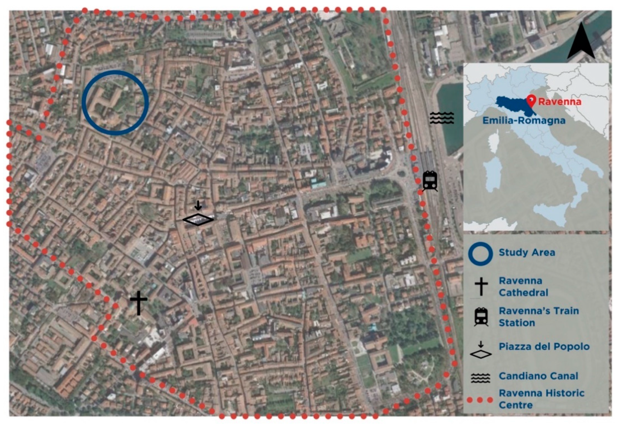
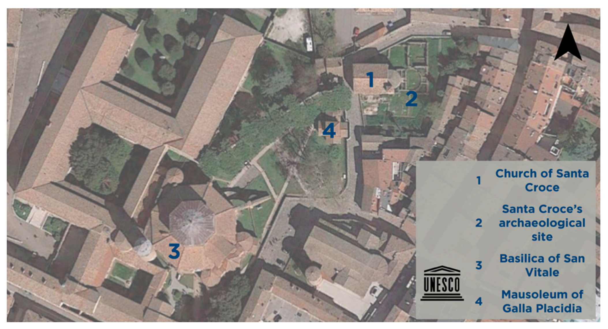
Table 1.
Strengths and weaknesses of Ravenna planning tools.
| Planning Tool | Strengths | Weaknesses |
|---|---|---|
| New urban plan (PUG) |
| n.a. |
| Current urban plan (PSC, POC, RUE) |
|
|
| the Management Plan of the UNESCO Early Christian Monuments serial site in Ravenna (PdG) |
|
|
| Sustainable Energy and Climate Action Plan (PAESC) |
|
|
| Municipal Civil Protection Plan (PPCC) |
|
|
| Provincial Spatial Plan (PTCP) |
|
|
| Provincial Emergency Plan (PPE) |
|
|
| Landscape Protection Plan (PTPR) |
|
|
| Emilia-Romagna Region Mitigation and Adaptation Strategy for Climate Change (SMACCER) |
|
|
| Flood Risk Management Plan (PGRA) |
|
|
| National Adaptation Plan to Climate Change (PNACC) |
|
|
Table 2.
Results of adaptive capacity assessment based on the current urban plan.
| Questions | Seismic Risk | Flood Risks | Subsidence | Climate Change |
|---|---|---|---|---|
| (1) Are there maps of the identified risks included in the planning tools at municipal level? | YES | NO, but there are at the level of the Po River District Basin Authority, more specifically in the PGRA. | YES | NO, but there are at national level, more specifically in the PNACC. |
| (2.1) Are there adaptation and/or mitigation strategies in the planning tools at municipal level? | NO | NO, but there are at the level of the Po River District Basin Authority. | NO, but there are at the level of the Po River District Basin Authority. | NO, but there are at the Emilia-Romagna Regional level. |
| (2.2) Which are these strategies? | None | In the PGRA some measures to reduce flood risk are delineated. | In the PGRA some measures to reduce flood risk are delineated. | The SMACCER provides some measures to deal with climate change. |
| (2.3) Whenever possible, are there prescriptive indications to minimize the hazard and/or the risk? | PARTIALLY POSSIBLE. Earthquake is a natural hazard that planning tools cannot control. However, urban plans can prioritize actions toward risk reduction. | PARTIALLY POSSIBLE. Flooding is a natural hazard that planning tools cannot control. However, urban plans can prioritize actions toward risk reduction. | YES. These prescriptions can be found in the following planning tools: PTCP, PTA. | PARTIALLY POSSIBLE, but there are only indications and strategic guidelines to mitigate climate change, not prescription. |
| (3) Are there monitoring programs for these strategies? (specify the territorial level) | NO | YES. (Po River District Basin Authority level) | YES. (Po River District Basin Authority level) | YES. (Emilia-Romagna Region territorial level) |
Table 3.
Results of adaptive capacity assessment based on the new urban plan (PUG).
| Questions | Seismic Risk | Flood Risks | Subsidence | Climate Change |
|---|---|---|---|---|
| (1) Are there maps of the identified risks included in the planning tools at municipal level? | YES | YES | YES | YES |
| (2.1) Are there adaptation and/or mitigation strategies in the planning tools at municipal level? | YES | YES | YES | YES |
| (2.2) Which are these strategies? |
|
|
|
|
| (2.3) When possible, are there prescriptive indications to minimize the risk/phenomenon? | PARTIALLY POSSIBLE. Earthquake is a natural hazard that planning tools cannot control. However, urban plans can prioritize actions toward risk reduction. | PARTIALLY POSSIBLE. Flooding is a natural hazard that planning tools cannot control. However, urban plans can prioritize actions toward risk reduction. | YES. These prescriptions can be found in the new urban plan. | PARTIALLY POSSIBLE, but there are only strategic indications to mitigate climate change, not prescription. |
| (3) Are there monitoring programs for these strategies? (specify the territorial level) | YES. (Municipality level) | YES. (Municipality level) | YES. (Municipality level) | YES. (Municipality level) |
Publisher’s Note: MDPI stays neutral with regard to jurisdictional claims in published maps and institutional affiliations. |
© 2021 by the authors. Licensee MDPI, Basel, Switzerland. This article is an open access article distributed under the terms and conditions of the Creative Commons Attribution (CC BY) license (http://creativecommons.org/licenses/by/4.0/).
Share and Cite
MDPI and ACS Style
Rosa, A.; Santangelo, A.; Tondelli, S. Investigating the Integration of Cultural Heritage Disaster Risk Management into Urban Planning Tools. The Ravenna Case Study. Sustainability 2021, 13, 872. https://doi.org/10.3390/su13020872
AMA Style
Rosa A, Santangelo A, Tondelli S. Investigating the Integration of Cultural Heritage Disaster Risk Management into Urban Planning Tools. The Ravenna Case Study. Sustainability. 2021; 13(2):872. https://doi.org/10.3390/su13020872
Chicago/Turabian StyleRosa, Angela, Angela Santangelo, and Simona Tondelli. 2021. "Investigating the Integration of Cultural Heritage Disaster Risk Management into Urban Planning Tools. The Ravenna Case Study" Sustainability 13, no. 2: 872. https://doi.org/10.3390/su13020872
Note that from the first issue of 2016, this journal uses article numbers instead of page numbers. See further details here.