Neoanthropocene Raising and Protection of Natural and Cultural Heritage: A Case Study in Southern Italy


Department of Architecture, University of Palermo, 90128 Palermo, Italy
*
Author to whom correspondence should be addressed.
Sustainability 2020, 12(10), 4186; https://doi.org/10.3390/su12104186
Submission received: 20 April 2020
/
Revised: 19 May 2020
/
Accepted: 19 May 2020
/
Published: 20 May 2020
(This article belongs to the Special Issue Historical Ecology, Archaeology and Biocultural Landscapes: Cross-Disciplinary Approaches to the Long Anthropocene)
Abstract
:Analyzing the human history on the planet, a conflictual relation was raised when humankind had started destroying the natural ecosystem and biota, and consequently, a capacity to induce environmental change has increased throughout human history in the so-called Anthropocene age. A ‘noosphere’-centered civilization could produce a non-disruptive new kind of anthropocentrism. This is becoming a new context to define Neoanthropocene based on a renewed homeostatic relationship between Earth and mankind. The potential application of this theoretical approach has been tested in drafting steps of Plan of Lucania Apennines, Valdagri, and Lagonegrese National Park, in southern Italy. Drafting the plan, the authors have applied a strategic approach based on environmental and cultural evidence and have drafted an interpretation plan for local growth, consistent with local resources. The result is a plan, shared with local stakeholders, in which the authors have proposed a multisectoral development plan based on a ‘cluster approach’ for regeneration: The main wild areas are reached through a visitor center or similar introducing facilities, and they are connected with historical centers, archaeological parks, ski areas, accommodation facilities, and other local services. The expected effect is the growth in number of chances to develop business in accordance with environment protection duty.
1. Introduction
In 2016, the Anthropocene concept [1] reached far beyond the traditional definition of a recent geological epoch characterized by human impacts on biogeochemical and biophysical processes, as notoriously defined by Crutzen and Stoermer [2]. The study of the Earth requires understanding of the system of human-derived forces and impacts on planetary processes. The Anthropocene essentially defines the growth of nested social-ecological systems where human–environment interactions are not bi-directional but reach across different spaces and times. In this sense, the relevance of ‘Complexity’ science to a new understanding of human–environment interactions become apparent. The first model formulation of the huge anthropic conditions and effects, and its interpretation, are now over 40 years old. It was born as the World3 Model and Limits to Growth research, promoted by the Club of Rome [3] not only for showing the horizon of crisis, but mostly for sketching the ground of action.
Recently, the International Geosphere-Biosphere Program (IGBP) community proposes a ‘second Copernican revolution’ in our understanding of the Earth [4], drawing upon ‘Complexity’ science to argue for a new generation of models that could simulate coupled human–environment relationships. In 2001, the Amsterdam Declaration extended these ideas to include the possibilities of threshold-dependent changes and tipping points.
Analyzing the human history on the planet [5], we can define an increasing conflictual relation in which humankind had started destroying the natural ecosystem and biota as far back as the Holocene (extending the spillover and opening our doors to COVID-19). The capacity to induce environmental change, however, has increased throughout the ages with a logarithmic–logistic function describing human population growth. Technology and socioeconomic conditions relate to this function and they are described in it. However, the ‘noosphere’ concept [6] could contribute to a new period where people carefully calculate relationships with the earthly universe in order to maximize the joined wellbeing of people and the environment.
A wide adoption of the ‘noosphere’ concept would be the inception of a non-disruptive new Anthropocene, that we propose to call Neoanthropocene, consistent with a radical innovation towards a renewed homeostatic relationship between Earth and mankind [7].
The Neoanthropocene age is announced by several worldwide avantgardes, and many ongoing experiments and consolidated practices are testing the necessary transition. The National Park of Lucania Apennines, Valdagri, and Lagonegrese in southern Italy, in the so-called ‘Mezzogiorno’, is one of the most relevant examples of the suggested transition from the Anthropocene (the Paleoanthropocene indeed) to the Neoanthropocene. In other words, the perfect example of a renewed circular alliance between Earth and mankind, ecology, and culture [8,9,10].
So, the Lucania Apennines Park’s planning has been a fruitful occasion for investigating a new paradigm in a circular approach to nature preservation and territorial development, testing a new protocol based on the fertile relationship among multiple interests, stakeholders, and competences.
Starting from the theoretical framework adopted for the plan of the National Park, the paper describes the case study current situation and the adopted solutions to meet the challenge of a heritage based growth of a park in which the wilderness is functionally joined with the seminatural areas and anthropic land uses. The results are focused on planned solutions for a new alliance between man and nature in the Park. At last, the discussion focuses on how to balance environment preservation and community development: It proposes a solution for the integration of nature sanctuaries and human activities, as fully as possible.
2. Materials and Methods
2.1. Circular Development and Circular Metamorphosis: A Theoretical Framework for the Plan of the National Park
During the euphoria for the Anthropocene, some reflective and militant planners have taken up the challenge to develop an effective local sustainable growth based on community engagement, environmental regeneration, and integrated goals for a whole sustainable development, in terms of social, cultural, economic, and overall environmental point of view. Visionary and pragmatic at the same time, they are convinced that we need to accept the challenge to live in the Neoanthropocene, described as a ‘good Anthropocene’ [11]. Designing the transition to this new era and reactivating the traditional alliance between human and natural components as co-acting forces [12] is guided by the ethics of a responsible project to integrate people and nature, the human habitat, and the environment, as collective responsibility towards Global Change beginning with the huge and accelerated footprint of human habitat [8,13,14,15,16].
In order to achieve a Neoanthropocene strategy for Lucania Apennines, we worked on it as researchers, teachers, and planners, with a responsible and militant approach, for drafting the plan of the National Park, as a multidisciplinary workgroup.
Since 2012, the EU Commission has clearly stated that more intelligent, sustainable, and competitive development requires a paradigm shift in which the territory is construed as a primary resource, considered the holder of ‘development cells’, which are too often underused or mystified with regard to their real potential for use [17]. Cities designed and built on land rent—on which Italy set a benchmark—need to be replaced with cities of social and cultural profitability, value creation, and production of jobs, based on a renewed circular alliance between rural and urban resources [10] and therefore more responsible. In rural-urban growth strategies, new urban policies towards the lifecycle approach (life cycle assessment) are needed: From the procurement of raw materials to the end of the cycle using as little energy and resources as possible and, instead, reactivating latent energy.
Human habitat will have to act within a new evolutionary model, the result of innovation produced by the third industrial revolution and by start-ups, actions of makers, and energy generated by creativity and by metamorphosis of circular economy. This urban model could be more responsible and capable of reshaping the objectives of tangible and intangible asset production, of revising energy and mobility protocols, and above all, of rethinking the settlement model.
It is possible thanks to a new holistic way of thinking that elicits reuse, recycling, and creative evolution within a ‘Capitalism 4.0′ [18], which generates the next economy [19] created from the integration of renewable energies and circular economy, able to produce new value from the re-cyclical process of new urban metabolism. The economic model supporting the territories in the circular society must be able to generate local value, rather than an extractive economy that creates dependence on the exogenous strategies of large companies. We work on a regional economy guided by a social agenda.
The task of decision-makers, planners, architects, citizens, and enterprises is to work on rural-urban settlements characterized by cycle flows—some still vital, others produced by surplus, and by the overproduction of changing urban complexes. The circular approach needs also to work on the discontinued urban fabric and transforming infrastructure networks: They need to be addressed through their modification, removal, or reinvention, thanks to which the components are recreated, without destroying them, and by changing their functions in pursuit of a generative view and increasing their creative resilience. Recycling and changing the settlement structures will be the issue that guides rural-urban habitats more and more constantly fluctuating between conservation and transformation [20], identity and innovation, in an accelerated metabolism of lifecycles.
Recycling is not only one of the main keywords of the action of urban planning, architecture, and design [21], but is also one of the most powerful guiding thoughts in the transformation from a wasteful linear economy to a regenerative circular one for cities and territories that wish to pursue sustainability, quality, and creativity [22]. In the circular economy, there are two types of material flows: Organic ones, capable of being replenished in the biosphere, and technical ones, destined to increase in value in a system in which all activities, starting from mining and manufacturing, are organized so that the waste of one phase becomes a resource for the following one. According to the principles of the circular economy, nothing is waste and everything that is discarded from one production process is the raw material for another production process. Moreover, the very design of a product is based on the possibility of dismantling its parts and reusing them in subsequent production cycles, based on supply chain cooperation and new production networks: A more creative ‘planned recycling’ instead of consumerist planned obsolescence.
Furthermore, the circular growth movement aims to change the current linear system on which our industrial society is based, into a cyclical system, replacing the ‘produce, use, and throw away’ process with a more fertile one of ‘produce, use, and reuse’ [23]. The principles of the circular economy raise the fundamental question of how the recycling of materials, semi-finished products, scraps, products at the end of the cycle of use, and biomass could contribute to the growth of a more responsible and less erosive GDP; so that the production value would be maintained for longer through reuse and, where possible, up-cycling, triggering a new cycle of sustainable prosperity that generates new services in a fertile combination of new products, lower environmental impact, and the elimination of toxicity.
A more open and collaborative circular society based on sustainability and sharing is the catalyst that allows the economy to transfer its effects to the territory and lifecycles of the communities, activating and extending territorial dividend [24]. A circular society demands new political responsibility—mainly taking charge of urban planning—so that cities may once again be welcoming to people, attractive for ideas, generative for businesses, and supportive to the community archipelagos. It requires the implementation of concrete actions to guarantee a new balance between rural, urban, and developable, between landscape and infrastructures, not just placing limits on the indiscriminate use of land, but above all, stimulating, encouraging, and rewarding the reuse of already urbanized areas and the densification of functions. Planning cities, territories, and landscapes in the emerging Neoanthropocene means rejecting the complacency of a ‘molecular’ approach: We need a new long-sighted vision to look towards the innovation horizon by looking back and retrieving wisdom, rituals, and structurally self-sufficient circular practices not yet seduced by the demon of anthropic development.
We also need effective paradigms and concrete projects, or commitments, to serve a discipline of urban planning that knows how to influence the urban metabolism, reusing the local resources and flows to be put back into circulation. Although often fragmented or weakened, these flows are still able to generate new fabric if reactivated by the vital energy produced by the cycles of water, food, energy, nature, waste, people, and goods. Flows that have an impact on the daily life of cities, and that inevitably act on a large scale, contribute to the reticular connection of settlements. Reconnecting them with a holistic view of the metabolism is one of the greatest challenges for urban planners, designers, administrators, and citizens to give new impetus to the circular Neoanthropocene, connecting its technical components with its social and moral dimensions [25].
Finally, we need new types of urban and regional planning with localizing strategies rather than comprehensive planning, plans that work with simple and adaptive rules rather than masterplans, and generative settlement actions alongside regulatory plans [26].
2.2. The National Park of Lucania Apennines, Valdagri, and Lagonegrese: A Case Study
Dealing with the transition from the disruptive Anthropocene to the generative Neoanthropocene is not easy, but the strategy for the Plan of the National Park of Lucania Apennines, Valdagri, and Lagonegrese can be considered as a focused example to understand what the transition implicates. The National Park is in the center of southern Italy, in the Basilicata Region, and entirely included in the Province of Potenza.
The Park boundaries include three areas: Lucania Apennines in the north—very important mountain landscapes and protected habitat, listed in Natura 2000 project are the peculiarity of this area; Valdagri in the middle—along the Agri river, lakes, and wet habitats, has important archaeological sites, some relevant historical centers define a network of cultural and natural sites; and Lagonegrese in the south—focused on the Sirino Mountain, the area is the natural link between Lucania and Calabria Apennines. The Presidential Decree that established the National Park in 2007, focused the goals of the park on:
- Conservation species, plant associations, geological formations, paleontological singularities, biological communities, biotopes, natural processes, hydraulic and hydrogeological balances, ecological balances;
- Protection of the landscape;
- Application of land management methods suitable for promoting integration between man and environment by maintenance and development of traditional agro-forestry-pastoral activities;
- Promotion and development of traditional and organic agriculture through appropriate forms of incentives for the conversion of existing crops and technical assistance to businesses;
- Forest conservation and management of forest resources through interventions that do not change the fundamental characteristics of the ecosystem;
- Promotion of education, training, and scientific research activities;
- Compatible tourism and recreational activities;
- Support and enhancement of compatible production activities;
- Protection and enhancement of the customs and traditional activities, as well as the cultural expressions proper and characteristic of the identity of the local communities;
- Respect for the ‘open fields’ uses that are exercised according to local customs.
However, the general goals request a specific plan framework: In fact, the Park’s natural and cultural quality is dependent upon changing a 50-year inconsistent development, dominated by the crude oil extraction, storage, and transport through the oil pipelines.
In order to meet the challenges of a new growth for the Park community and for the protection of natural sanctuaries, the planning path is based on pre-planning, assessment, and synthesis, as below:
- A preliminary pre-planning step concerning statistical data and assessment of the related socio-economic condition;
- The assessment of the territorial structure of the Park concerning natural and cultural resources, historical centers and other heritage; (b) the ongoing projects and programs relevant in preservation and valorization of the Park heritage, as opportunities for further actions;
- The SWOT analysis that is the synthesis of pre-planning and structural assessment.
Sectoral analysis, such as habitat, ecosystems, wildlife, freshwater, cultural heritage, etc., were provided by the National Park Authority or by other experts in the workgroup as input to produce the maps with the overlay mapping approach [27], in ArcView GIS 8.x software environment.
As described in paragraph 3, the result of this analytic and interpretative path is the ‘interpretation plan’ structured as framework of strategies for local growth and below described.
2.3. Evidence in Local Context
The natural landscape of Lucania Apennines, Valdagri, and Lagonegrese National Park is the expression of the paleoclimatic events of southern Apennines that have enriched the flora of this territory with interesting species of considerable interest, as well as long historical relationships between man and nature that have created an inseparable link between biological wealth and cultural diversity in material and immaterial aspects. The result of this process is a floristic diversity with the presence of rare or very rare species. The variety of the environmental pattern also manifests itself on the vegetation, which diversifies in relation to the altitude and the different substrates: This territorial mosaic is also diversified in relation to the geomorphological characteristics that enrich a heterogenous landscape. In general, natural and semi-natural systems are the majority in the Park: Only 13% of surfaces are covered by artificial systems, such as agricultural surface.
Concerning the human settlement, strictly joined to the natural and seminatural environment, the National Park is composed of 30 municipalities with a very old population: The age pyramid of total population highlights a typical situation in Italian inner areas, and so a very small group of young people and a larger and larger group of old age people compose the local population set, as in Figure 1.
This characteristic is going to produce depopulation in many little towns such as in Carbone where people who are more than 75 years old make up 75% of total population. Carbone is the maximum case of this faster and faster depopulation; furthermore, recent analysis of the social and sustainable assessment of Province of Potenza, in which the Park sits, has confirmed that in the Park, the population is old aged and accompanied by the relevant problem of employment ratio.
Apart from the depopulation described above, the general good quality of life is relevant in compensation of critical status of abandonment, thanks to landscape, environment, low pollution levels, cultural heritage, and quality of local facilities [28].
Furthermore, some historical-medieval and ancient origin-centers (Marsico Nuovo, Abriola, Anzi, Castelsaraceno, Gallicchio, Moliterno, San Chirico Raparo, Spinoso, Tramutola) are included in the Park boundaries: They are occupied, and this is a very important opportunity because nature and human history are connected in the Park interpretation and narrative for local population, tourists, and researchers.
However, some weaknesses and threats are related to anthropic activities, such as the crude oil extraction and production chain. If we consider the extraction sites, no oil field extends into the park boundaries, but its presence in the closer surroundings can influence the environmental quality of the Park. The local activists and ecologists fight against the crude oil extraction activities, and thanks to the establishment of the National Park, this activity was banned: To date, the oil extraction–production chain is entirely placed out of the Park boundaries, but the pipelines cross the park. The radical proposal by people, activists, and ecologists is focused on the banning of the crude oil production chain from Basilicata, assessed as inconsistent with the local natural and cultural heritage.
2.4. The Structural Analysis: Current Status and Ongoing Priority Projects
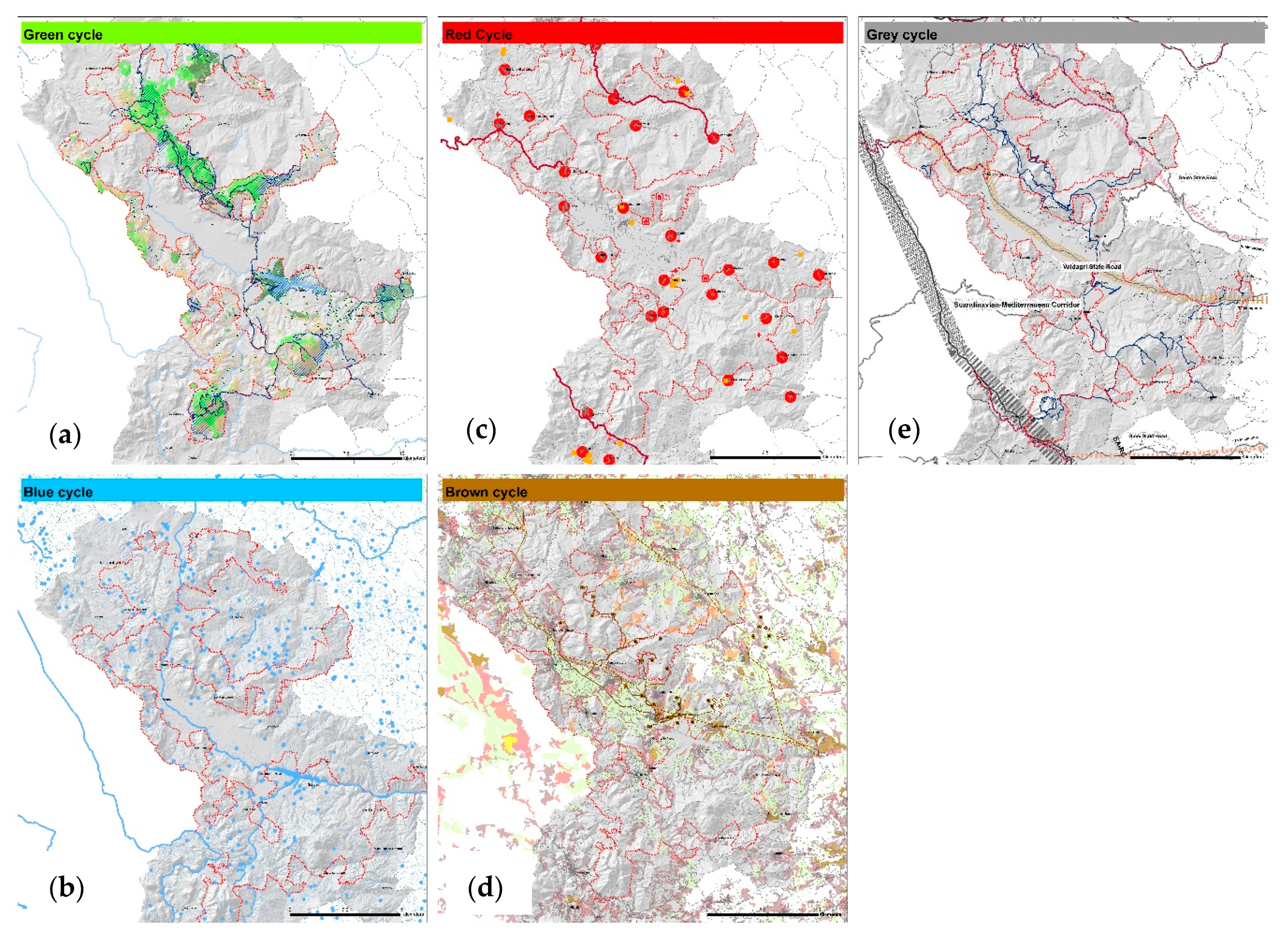
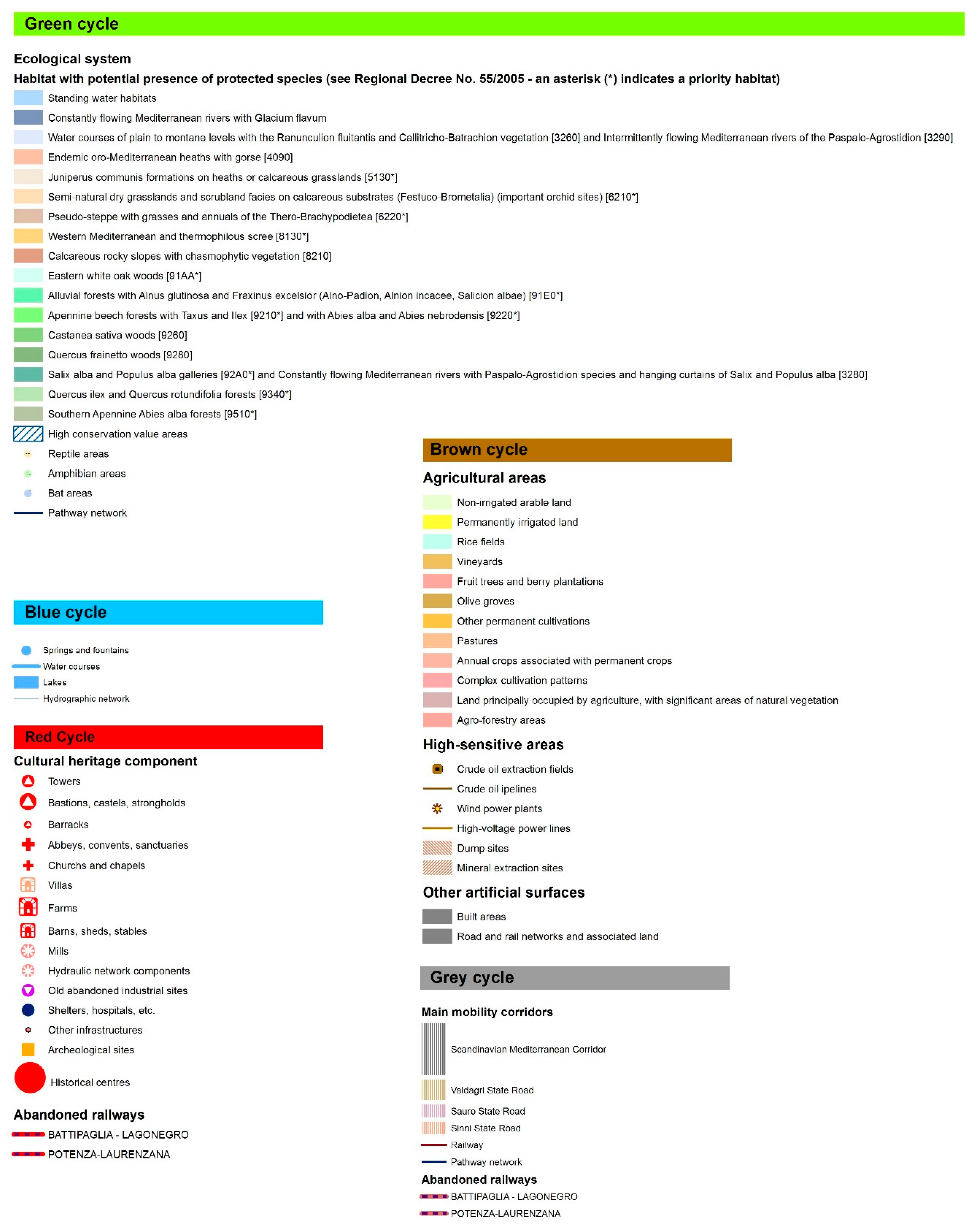
In order to assess the current situation and to check how many resources could be used to develop a protection and promotion of the Park, a specific analysis was drafted, called a structural analysis [29]. It is based on the overlay mapping technique [27] to assess the interactions among the natural and anthropic systems. Furthermore, the analysis goal is to define what natural and anthropic components identify the Park and can contribute to its circular development. To do so, the overlaid maps are divided in four categories corresponding to the main life cycles [30], as in Figure 2 and Figure 3:
- The blue and green cycle, concerning the most relevant component of green coverage across the Park and the water, above all rivers, lakes, and freshwater springs, based on priority habitat map and on hydrographic network, as provided by National Park Authority and Regione Basilicata;
- The red cycle, concerning cultural heritage, its relations, and historical networks, provided by Regione Basilicata Geographical Information System, updated on field by the authors;
- The brown cycle, concerning local agriculture production system, high-sensitivity areas, and other sealed soils, based on CORINE map and updated at local level by Regione Basilicata and by the authors;
- The grey cycle, concerning infrastructure network, mainly roads and railways, used and abandoned, provided by Regione Basilicata Geographical Information System.
The research group has synthesized findings in the prevalence of wilderness. The National Park is composed of 69,000 hectares, 14 Natura 2000 sites recognized in regard to EU habitat protection policy [31] (12 Special Conservation Zones and 2 Special Protection Zones), 1 International Bird Area and 2 Important Plant Areas, 11 peaks over 1500 m high and 1 peak over 2000 m high, a hydrographic system composed of the Agri river and its tributaries that feeds Pertusillo artificial lake 75 square kilometres large, Laudemio lake, and a wide number of freshwater springs, geological sites, and singularities. Each habitat is composed of a higher and higher level of biodiversity, such as the old woods or the Apennine meadows.
Regarding the cultural heritage, in the National Park, there is the Grumentum archaeological park—the most important Roman city in the area—many medieval castles and monasteries, historical centers, and sanctuaries, often in the mountains.
Regarding the immaterial heritage, food and art and crafts reveal a multifaceted use of local resources that has modelled the anthropic landscape in depth.
On the other hand, the research group focused on the ongoing transformations, mainly on EU structural fund granted projects that are the financial backbone of the conservation and promotion projects: The result is an amount of almost €40,000,000.00 for the realization of priority projects in the preservation and development of the National Park.
Table 1 shows the priority list for the protection and enhancement projects selected by the National Park Authority: It is clear that the primary necessity of protection is in Park natural capital (woods, planted areas, etc.), but it is otherwise clear that the park community is making a special effort to draft a new identity-centered development strategy.
2.5. The SWOT Matrix as Synthesis of Targeted Analysis
At the end of the structural analysis, the research group produced a SWOT matrix to select endogenous and exogenous resources. It is a widely used study undertaken by an organization to identify internal strengths and weaknesses, as well as external opportunities and threats, and it is focused on a non-neutral point of view: Our initial pre-planning idea and intended objective to analyze the emerging Neoanthropocene growth mirror the SWOT matrix items and shape up the whole plan.
In detail, strengths derive from a complex system of ecological, environmental, cultural, and settlement resources present in the National Park:
- Ecological continuity of the environmental system, despite settlement issues relating to crude oil extraction activities;
- Presence of a system of high-valued historical centers;
- Towns relevant to local urban facilities;
- Agricultural resources and ‘niche’ production (e.g., legumes).
Weaknesses derive from the presence of critical conditions, specific to the territory of the National Park, inherent to it or deriving from a consolidated tendency:
- Old-age population (peaks of the elderly population, over 75, in the smaller municipalities);
- The infrastructure network is exclusively based on the backbone of State Road Val d’Agri, and Naples, the nearest metropolitan context, is far from the Park because of the weak infrastructural connection;
- Economic dependence on the oil extraction chain and consequent weakness of the economic sectors connected to the protection and enhancement of the park’s resources.
Opportunities derive from the ongoing projects driven by National Park, Regione Basilicata, and local rural development agents, in detail:
- Projects for enhancement of local resources, already authorized and activated with the support of the National Park Authority;
- Activities of GIS cataloguing for habitats, plant, and wildlife;
- New information and communication technologies and infrastructures for training and environmental dissemination;
- Projects aimed at promoting entrepreneurship centered on the local resources;
Threats derive from projects activated by territorial or extra-territorial stakeholders and which may cause a reduction in the environmental quality and resources present in the Park, mainly:
- Enhancement of the oil treatment plant with highly probable risk for biodiversity, soil and water quality, and human health.
3. Results
3.1. The Inner Area Policy as a Beacon for Development
The targeted analysis results enlighten the nature of Lucania Apennine peripherical and ultra-peripherical areas and focus on the relevance of the Park as a beacon in local development policies.
Distance far from metropolitan contexts, as a weakness, and high-level quality of life of inner areas, as a strength, are the main strategic resources for a disruptive and radical vision: In this context, a nature protection framework needs to connect to social and economic policies in order to innovate the approach to local development in the medium-long term, starting from innovative actions in a new—and sustainable—development chain composed by climate change response, rural economy, soil consumption reduction, and resilient approach [32,33,34].
The new vision implicates networking among the towns, update of infrastructures, re-negotiation of energy production model, as a more complete regenerative capacity for social, economic, and production tissues [35].
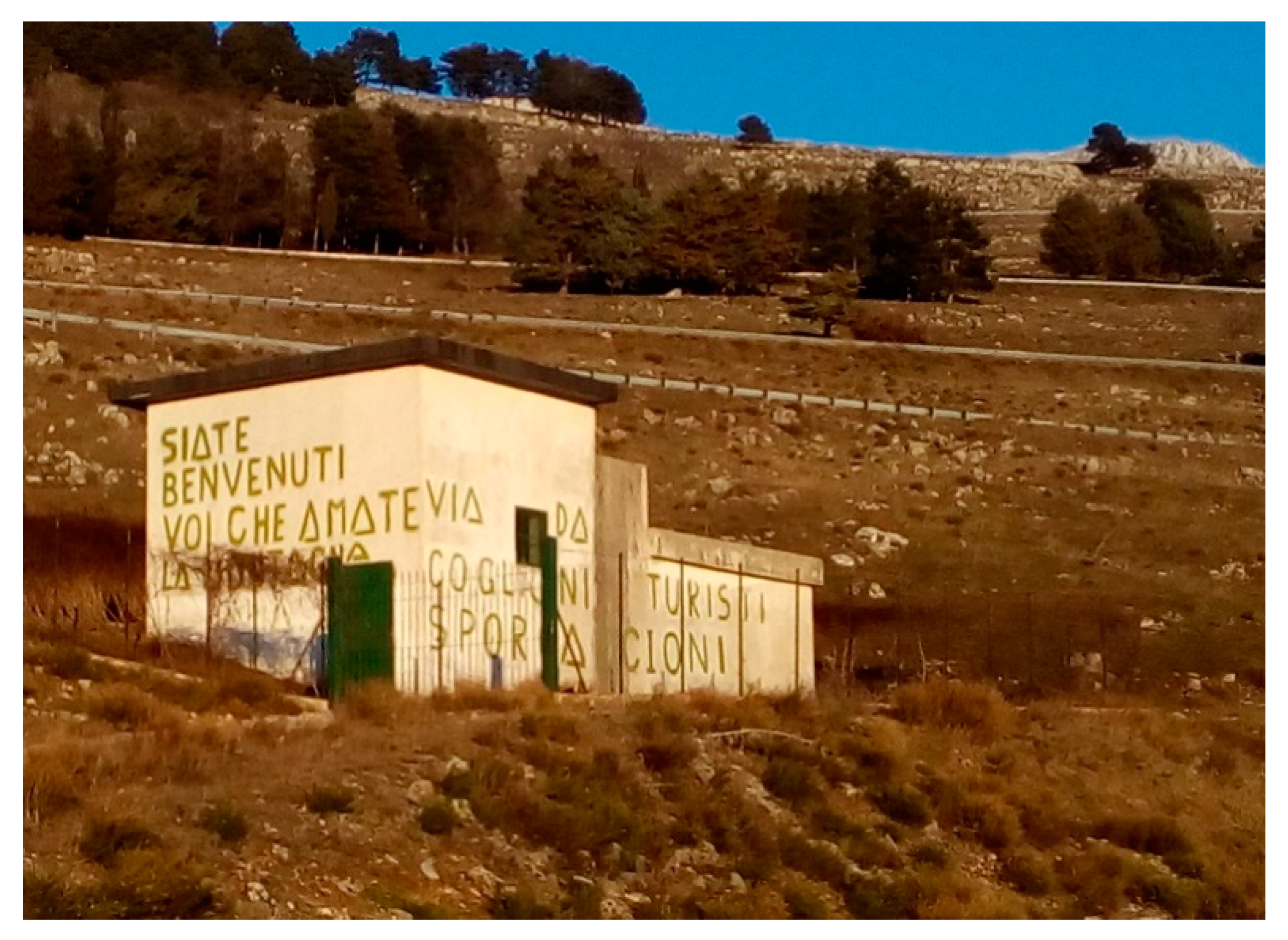
The Lucania Apennine Park can strive to [36,37] become an antifragile community, better and stronger than before the crisis, able to promote a non-dissipative circular metabolism, to climate change proof and maintain biophysical and socio-economic balances, alongside the urgent need to improve collaboration between users and supply chains, acting as a circular habitat instead of an unsustainable consuming one. The starting point is clear: People feel the ethical responsibility for protection and innovation, as in Figure 4.
The Lucania Apennines Park Plan, therefore, manages the territory involved for long-term uses, facilitating the change of functions where necessary, as a more efficient alternative in terms of carbon emissions. A commitment is needed so that the extension of the life cycle of existing human and natural habitats becomes a new or renewed opportunity to strengthen the relationship between communities and territories through environmental sustainability and resilience.
3.2. Interpretation for Drawing a Regeneration Flagship Project
As a consequence of the new vision for the Lucania Apennines National Park, natural and cultural heritage promotion strategies have started selecting local resources relevant to promoting and enhancing the Park’s identity. The interpretative relationships among the community, the park, and the experts are the basis to start a completely new regeneration process. However, the vision requires designing and implementing new flagship projects.
Therefore, the research group has drawn a development model, based on two widely known models:
The result is an ‘interpretation plan model’ based on specific knowledge that divides the Park in landscape contexts, homogeneous in natural, historical, and urban aspects. The model is drafted through four steps:
- Recognizing the naturalistic, cultural, and landscape heritage framework as described in ‘life cycle’ analysis;
- Integrating the current protection rule framework, especially the regional plan for protection and enhancement of the landscape;
- Recognizing the landscape units, as required by national law n° 394/91 [40];
- Extracting enhancement and transformation strategies, consistent with the natural, cultural, and landscape resources, and shared with the local and external stakeholders.
The ‘interpretation plan’ is also a communication strategy, activated within the regulatory context: It constrains the existing naturalistic, cultural, and landscape resources, and proposes all the methods useful for valorization, such as communication strategy, educational activities, and structures capable of taking up the challenges of communication in the field of the protection of resources [41]. It is expressed as a methodology for making the strategic framework that contributes to the achievement of landscape quality objectives.
The core of the interpretation plan is the recognizing of landscape units: The landscape assessment has produced six landscape units, in which a specific identity typifies and distinguishes the places. These units are:
- High-mountain system of the Lucania Apennines, which is the wood and mountain Natural Park backbone;
- The Sirino mountain landscape that is the gate towards the Calabria Apennines, with lakes and peculiar geomorphology;
- The Raparo mountain with the historical Orthodox settlement;
- The Moliterno creek, with not very high mountains but with a peculiar Roman settlement centered in Grumentum. The unit is also characterized by a Medieval castle network;
- The Campania Felix and the ‘Two Valley Principality’ are composed of the wood at the west of Agri river;
- The Agri Valley, with Pertusillo artificial lake and ‘Murge di Sant’Oronzo’ clay landscape. The Valley is the main path for peoples who arrived and colonized Lucania while the ancient towns were settled in the hills around the Valley.
The landscape units include the whole Park, while the ‘interpretation plan’ needs otherwise to select some beacon landscapes that are selected places for promotion and regeneration activities, such as Brienza landscape hub, Pignola lake and wetland, Viggiano Holy Mountain, Laurenzana fir wood, Grumentum Archaeological Park, and Pertusillo Lake. They are not in hierarchical order with the six units but would represent relevant examples of the Park identity.
In accordance with the regulatory and zoning aspects aimed at the protection of National Park environment, this work step ends with the selection of an interpretation theme summarized in the expression ‘wilderness’: Actually, also where nature is ‘artificial’ as in the case of Pertusillo lake, it is capable of conceptually, perceptually, and structurally prevailing over anthropic presence.
The interpretation plan for the Park, therefore, is not sub-articulated into units, which could fragment and pulverize the interpretation theme, but aims at communicating and enhancing the landscape contexts defined and identified within a functional scheme in which the natural and cultural resources, the infrastructure network, and the leisure facilities are connected by slow mobility network.
4. Discussion: How to Balance Environment Preservation and Community Development? A ‘Cluster Approach’ for Circular Regeneration
The peculiar components in the National Park environment have created a deep reflection on the operative way to implement the development paradigm shift proposed in targeted research results, in discussions both with local communities, stakeholders, and national/regional government, in order to balance the preservation duty and the development opportunities.
This is more difficult if we consider the rub between preservation and crude oil extraction activities: In a simplistic view of development strategy, preservation and development are on opposite sides. According to circular metamorphosis paradigm, this is not true if we consider a development strategy based on the environment and cultural capital stock.
On the basis of current trends in the National Park and referring to the theoretical framework as above described, we are absolutely convinced that only a new approach can reset an effective social and economic development in Lucania Apennines.
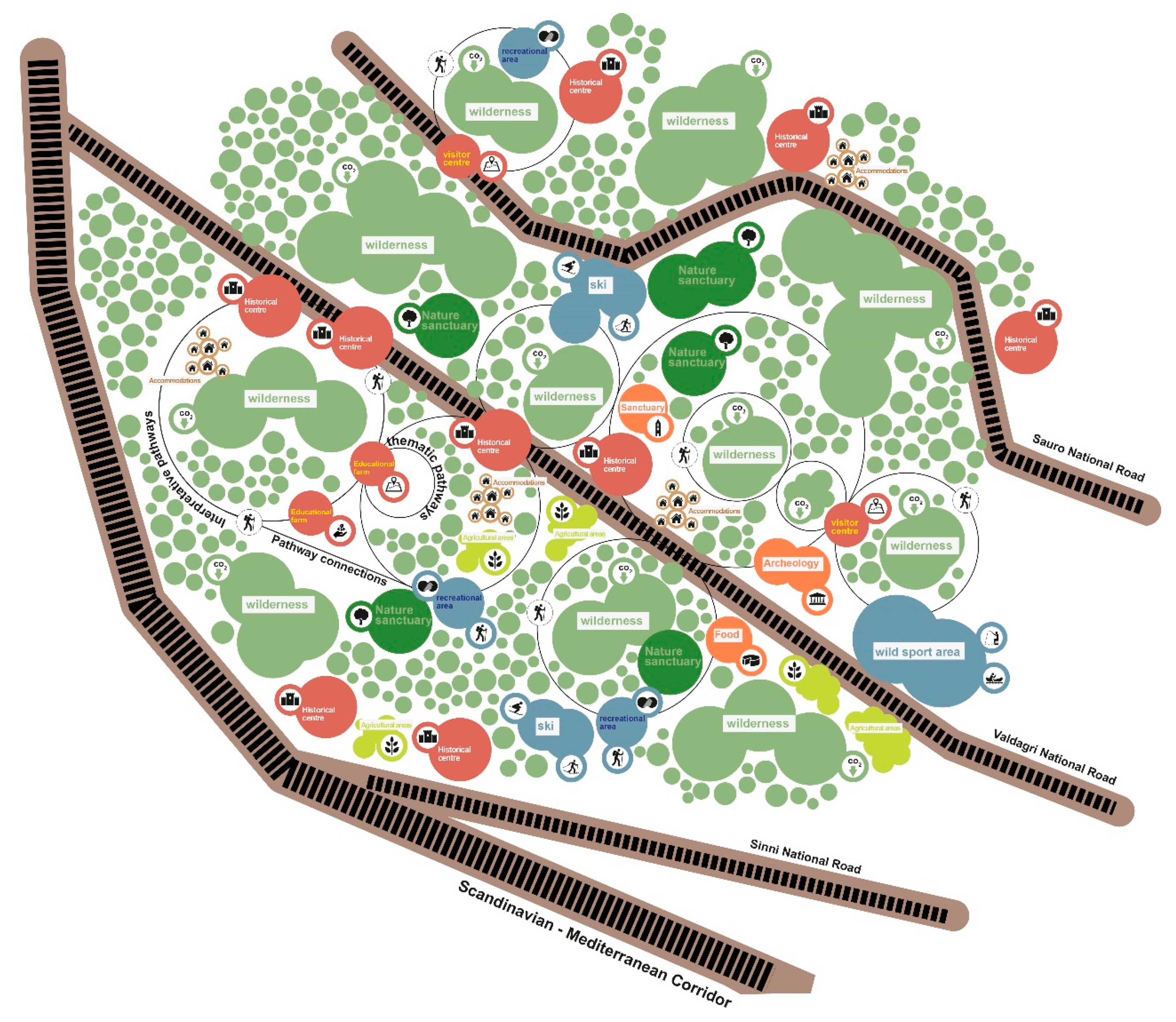
The concept we have proposed to National Park Authority is a ‘cluster approach’ as in Figure 5: The metaphor, such as in UN and non-UN organization disaster response networks, means the necessity of an integrated approach to environment-based local development.
In other words, one or a small group of local stakeholders has a chance to develop an interpretation plan, starting from a local cluster composed of some local components, updating it to the next level in a fertile circular process able to achieve transcalarity and reticularity.
Main resources are the wild areas—the A zones in National Park zoning map—where the plan decides upon the limited level of use, and accessibility is limited. Some of these areas have tourist activities or sanctuaries inside or in close proximity and, where it will be possible, the plan establishes places for interpretation and dissemination. These areas can be crossed and used in accordance with the Park regulations, but the mere experience of the place, through the paths, can guarantee the visitor will understand the experience of Wild Nature that the Plan is inspired by. Capturing CO2 is the first strategic and interpretative mission of these areas.
In the field of the interpretation approach, we propose an action plan composed by a set of integrated policies and actions:
- Agricultural activities into the park are needed by a consistent and equilibrated land use: It is relevant for the purposes of preserving and spreading the sense of community and the traditional use of landscape, by the continuity of cultivation techniques and local productions;
- Accommodation and restaurant facilities in the park area make desirable (or even necessary) the development of food and wine supply chains;
- Traditional cultural activities, including festivals and religious customs (especially those related to traditional worship on the mountains) will aim at increasing the knowledge of the places and the vitality;
- Pathways and visitor centers are the core business of interpretation activities into the National Park: Dissemination activities centered on inhabitants and kids could improve the identity perception;
- Leisure, sport, and accommodation facilities ought to be integrated with protection and interpretation plan to avoid touristification effects. We are certain that the integration of these tourist activities within visitor centers and structures for active protection, such as in ski area and other sport facility areas, will become more and more economically sustainable and compatible with the nature protection.
In 2018 and 2019, the National Park Authority organized some engagement activities: A photo competition for kids and students to attract interest of young people, and three technical meetings with the local stakeholders to explain and amend the plan strategies and rules. During the meetings, the stakeholders were divided in five groups focused on the geographical areas of the National Park and their issues: The results of participation meetings more and more confirmed that the community is, and should continue to be, engaged in environment-oriented development in Lucania Apennines and now the Park is waiting for the official approval by National Park Community.
5. Conclusions
Our applied research demonstrates that National Park planning needs to be changed, facing the inconsistency of many aspects, both in national and in local framework:
- The national protection law is based on the total protection of sanctuaries, that are apart from anthropic transformation;
- The Natura 2000 sites request—often in natural sanctuaries—the presence of man to manage and to maintain alive the ecosystem, such as prairie or some types of woods;Local communities ask for a renewed strategy for growth in which they would feed a human–environment integrated development framework.
In comparison with traditional approach of separation between nature sanctuaries and human activities, the new plan produces a paradigm shift, to induce a fertile relationship among all the components of local communities and to define a positive environmental restoration.
Based on the plan scenario, we will wait for long-term consequences in planning and actions in both regional land use management and environment protection and raise the awareness of the advantages of a protection model based local resource development.
Author Contributions
All authors have contributed to the whole work. In particular, for writing—original draft, review and editing, the paragraphs were written as follow: 1. Introduction, M.C. and D.R.; 2.1. Circular Development and Circular Metamorphosis: A Theoretical Framework for the Plan of the National Park, M.C.; 2.2. The National Park of Lucania Apennines, Valdagri and Lagonegrese: A Case Study, M.C.; 2.3. Evidence in Local Context, D.R.; 2.4. The Structural Analysis: Current Status and Ongoing Priority Projects, D.R.; 2.5. The SWOT Matrix as Synthesis of Targeted Analysis, M.C. and D.R.; 3.1. The Inner Area Policy as a Beacon for Development, M.C.; 3.2. Interpretation for Drawing a Regeneration Flagship Project, D.R.; 4. Discussion: How to Balance Environment Preservation and Community Development? A ‘Cluster Approach’ for Circular Regeneration, M.C. and D.R.; 5. Conclusions, M.C. and D.R. All authors have read and agreed to the published version of the manuscript.
Funding
This research received no external funding.
Acknowledgments
Authors’ research field activities and results were produced in a multisectoral project group composed of many experts and stakeholders, as follow: National Park Authority’s management group and technical officers; the research group, composed by RPA spa with Salvatore Corlianò and Dino Bonadies for general aspects, Sandro Amorosino for law aspects, Evagreen Ltd. with prof. Giuseppe Bazan and Dino Erdfeld for environmental aspects, Emanuela Coppola, Remo Votta, Valeria Mauro for anthropic aspects.
Conflicts of Interest
The authors declare no conflict of interest.
References
- Verburg, P.H.; Dearing, J.A.; Dyke, J.G.; Van Der Leeuw, S.; Seitzinger, S.; Steffen, W.; Syvitski, J. Methods and approaches to modelling the Anthropocene. Glob. Environ. Chang. 2016, 39, 328–340. [Google Scholar] [CrossRef] [Green Version]
- Crutzen, P.J.; Stoermer, E.F. The Anthropocene. IGBP Int. Geosph. Biosph. Program Newsl. 2000, 41, 17–18. [Google Scholar]
- Meadows, D.; Meadows, D.; Randers, J.; Behrens, W. The Limits to Growth; Potomac Associates Books: Washington, DC, USA, 1972. [Google Scholar]
- Schellnhuber, H.J. “Earth system” analysis and the second Copernican revolution. Nature 1999, 402, C19–C23. [Google Scholar] [CrossRef]
- Turner, B.L., II; McCandless, S.R. How Humankind Came to Rival Nature. A Brief History of the Human–Environment Condition and the Lessons Learned. In Earth System Analysis for Sustainability; MIT Press: Cambridge, MA, USA, 2004; pp. 227–243. [Google Scholar]
- Vernadsky, V. The biosphere and the noosphere. Am. Sci. 1945, 33, 1–12. [Google Scholar]
- Carta, M. The Augmented City. A Paradigm Shift; List Lab: Trento, Italy, 2017. [Google Scholar]
- Fusco Girard, L.; Nocca, F.; Gravagnuolo, A. Matera: City of nature, city of culture, city of regeneration. Towards a landscape-based and culture-based urban circular economy. Aestimum 2019, 74, 5–42. [Google Scholar]
- Mostafavi, M.; Doherty, G. Ecological Urbanism; Lars Müller Publishers: Baden, Germany, 2016. [Google Scholar]
- Schroeder, J.; Carta, M.; Ferretti, M.; Lino, B. (Eds.) Territories. Rural-Urban Strategies; Jovis: Berlin, Germany, 2017. [Google Scholar]
- Rockström, J.; Klum, M.; Miller, P. Big World, Small Planet; Yale University Press: New Haven, CT, USA, 2015. [Google Scholar]
- Brugmans, G.; Strien, J. IABR−2014−URBAN BY NATURE—Catalog 6th International Architecture Biennale Rotterdam; IABR: Rotterdam, The Netherlands, 2014. [Google Scholar]
- Owen, D. Green Metropolis: Why Living Smaller, Living Closer, and Driving Less Are the Keys to Sustainability; Penguin Publishing Group: London, UK, 2009. [Google Scholar]
- Hall, P. Good Cities, Better Lives: How Europe Discovered the Lost Art of Urbanism; Taylor & Francis: London, UK, 2013. [Google Scholar]
- United Nations Environment Programme. Global Environment Outlook 2000; Taylor & Francis: London, UK; Sterling, VA, USA, 2013. [Google Scholar]
- UN-Habitat. Planning Sustainable Cities: Global Report on Human Settlements 2009; Taylor & Francis: London, UK; Sterling, VA, USA, 2016. [Google Scholar]
- European Commission; Directorate-General for Research and Innovation. Global Europe 2050; Publications Office of the EU Commission: Luxembourg, 2012. [Google Scholar]
- Kaletsky, A. Capitalism 4.0. OECD Obs. 2010, 279, 23–24. [Google Scholar]
- Brugmans, G.; van Dinteren, J.; Hajer, M. IABR 2016. The Next Economy; IABR: Rotterdam, The Netherlands, 2016. [Google Scholar]
- Bazan, G.; Barba, A.C.; Rotolo, A.; Marino, P. Geobotanical approach to detect land-use change of a Mediterranean landscape: A case study in Central-Western Sicily. GeoJournal 2019, 84, 795–811. [Google Scholar] [CrossRef]
- Ciorra, P.; Marini, S. Re-Cycle: Strategie per L’architettura, la Città e il Pianeta: [MAXXI, Roma, 1 Dicembre 2011–29 Aprile 2012]; Electa: Milano, Italy, 2011. [Google Scholar]
- Carta, M.; Ronsivalle, D. Territori Interni. La Pianificazione Integrata per lo Sviluppo Circolare: Metodologie, Approcci, Applicazioni per Nuovi Cicli di Vita; Aracne Internazionale: Roma, Italy, 2015. [Google Scholar]
- Ellen MacArthur Foundation. Towards the Circular Economy: Economic and Business Rationale for an Accelerated Transition; EMF: Chicago, IL, USA, 2013. [Google Scholar]
- Bonomi, A.; Della Puppa, F.; Masiero, R. La Società Circolare: Fordismo, Capitalismo Molecolare, Sharing Economy; DeriveApprodi: Roma, Italy, 2016. [Google Scholar]
- Sijmons, D. The Urban Metabolism. In IABR−2014−URBAN by NATURE—Catalog 6th International Architecture Biennale Rotterdam; IABR: Rotterdam, The Netherlands, 2014. [Google Scholar]
- Carta, M. Iper-strategie del riciclo: Cityforming © Protocol. In Urban Hyper-Metabolism; Carta, M., Lino, B., Eds.; Aracne Internazionale: Roma, Italy, 2015. [Google Scholar]
- McHarg, I.L. Design with Nature; American Museum of Natural History: New York, NY, USA, 1969. [Google Scholar]
- Province of Potenza. Benessere equo e Sostenibile Della Provincia di Potenza; UPI/CUSPI: Roma, Italy, 2016. [Google Scholar]
- Carta, M. Governare L’evoluzione: Principi, Metodi e Progetti per una Urbanistica in Azione; Franco Angeli: Milano, Italy, 2009. [Google Scholar]
- Carta, M.; Lino, B.; Ronsivalle, D. Re-Cyclical Urbanism. Visions, Paradigms and Projects for the Circular Metamorphosis; Listlab: Trento, Italy, 2017. [Google Scholar]
- The Council of the European Communities. Council Directive 92/43/EEC of 21 May 1992 on the conservation of natural habitats and of wild fauna and flora. Off. J. Eur. Communities 1994, L206, 7–50. [Google Scholar]
- Wilson, G.A. Community resilience: Path dependency, lock-in effects and transitional ruptures. J. Environ. Plan. Manag. 2014, 57, 1–26. [Google Scholar] [CrossRef]
- Carta, M. The Resilience Revolution. In Creative Heritage; Schroeder, J., Carta, M., Hartmann, S., Eds.; Jovis: Berlin, Germany, 2018. [Google Scholar]
- Carta, M. Eterotopie dell’Italia mediana. In Futuro. Politiche per un Diverso Presente; Rubbettino: Soveria Mannelli, Italy, 2019; pp. 225–250. [Google Scholar]
- Emery, N. Progettare, Costruire, Curare: Per una Deontologia Dell’architettura; Casagrande: Bellinzona, Switzerland, 2007. [Google Scholar]
- Carta, M. Comunità antifragili. Azioni per la qualità e la sicurezza del territorio italiano. In Futuro. Politiche per un Diverso Presente; Rubbettino: Soveria Mannelli, Italy, 2019; pp. 251–264. [Google Scholar]
- Taleb, N.N. Antifragile: Things That Gain from Disorder; Random House Publishing Group: New York, NY, USA, 2012. [Google Scholar]
- Carta, M. L’armatura Culturale del Territorio: Il Patrimonio Culturale Come Matrice di Identità e Strumento di Sviluppo; Franco Angeli: Milano, Italy, 1999. [Google Scholar]
- Council of Europe. European Landscape Convention; Council of Europe: Florence, Italy, 2000; Available online: https://www.coe.int/en/web/conventions/full-list/-/conventions/treaty/176 (accessed on 10 May 2020).
- Repubblica Italiana. Legge quadro sulle aree protette. N 394 del 06/12/1991. Gazz. Uff. Repubb. Ital. 1991, 292, 1–24. [Google Scholar]
- Tilden, F. Interpreting Our Heritage: Principles and Practices for Visitor Services in Parks, Museums, and Historic Places; University of North Carolina Press: Chappel Hill, NC, USA, 1957. [Google Scholar]
Figure 1.
National Park municipalities’ age pyramid. The strong incidence of the population in the older age groups, as a significant weakness for maintaining the social cohesion of Park territories, is evident.
Figure 1.
National Park municipalities’ age pyramid. The strong incidence of the population in the older age groups, as a significant weakness for maintaining the social cohesion of Park territories, is evident.

Figure 2.
Five life cycles defining the backbone of Lucania Apennines National Park: From top to bottom, left to right, (a) green main components, (b) the blue network, (c) cultural networks in red cycle, (d) brown soils, and (e) grey infrastructural networks.
Figure 2.
Five life cycles defining the backbone of Lucania Apennines National Park: From top to bottom, left to right, (a) green main components, (b) the blue network, (c) cultural networks in red cycle, (d) brown soils, and (e) grey infrastructural networks.

Figure 3.
The structural components in life cycle analysis. The summary of information used in cycle definition enables the composition of a structure map of the National Park.
Figure 3.
The structural components in life cycle analysis. The summary of information used in cycle definition enables the composition of a structure map of the National Park.

Figure 4.
A peculiar welcome to the National Park. A welcome to mountain lovers and an otherwise strong vade retro to its enemies: In a glance, for Lucania Apennine inhabitants, the mountain is a sacred place to be protected.
Figure 4.
A peculiar welcome to the National Park. A welcome to mountain lovers and an otherwise strong vade retro to its enemies: In a glance, for Lucania Apennine inhabitants, the mountain is a sacred place to be protected.

Figure 5.
The ‘cluster strategy’ for environment-based local development. The nature sanctuaries and wild areas are reached through a door, often a visitor center, and they are connected with historical centers, archaeological parks, ski areas, accommodation facilities, and other local services.
Figure 5.
The ‘cluster strategy’ for environment-based local development. The nature sanctuaries and wild areas are reached through a door, often a visitor center, and they are connected with historical centers, archaeological parks, ski areas, accommodation facilities, and other local services.


Table 1.
Priority projects in National Park protection and enhancement.
| Local Resources | Proposed Development Axis | ||||||
|---|---|---|---|---|---|---|---|
| Project Name | Nature | Culture | Local Identity | Economic Chain | Urban Metabolism | Interpretative Planning | Urban Smartness |
| 1. New touristic signage | • | • | • | • | |||
| 2. Reproduction environment for migratory fish protection activities | • | • | |||||
| 3. ‘Le porte del Parco’ project | • | • | • | ||||
| 4. Monumental trees GIS mapping | • | • | • | • | |||
| 5. Orchid GIS mapping | • | • | |||||
| 6. New birdwatching stations | • | • | |||||
| 7. Regional Ecological Network enhancement | • | • | • | • | |||
| 8. Carnages and plant modules for habitat protection | • | • | |||||
| 9. ‘Fare Rete con il Parco’—project for local network enhancement | • | • | • | • | |||
| 10. Local stakeholder digital platform for a new shared policy | • | • | • | ||||
| 11. Ski resort upgrading | • | • | • | ||||
| 12. Communication and interpretation activities ‘The Laurenza Beechwood’ | • | • | • | • | • | ||
| 13. Communication and interpretation activities ‘Sorgitora Park’ and ‘Agri Aqueduct’ | • | • | • | • | • | • | |
| 14. New Biodiversity Museum | • | • | • | • | |||
| 15. Touristic paths along the former ‘Calabro-Lucana’ railway, on the Padula MarsicoNuovo line and Pignola Laurenzana line | • | • | • | ||||
| 16. Training for guides | • | • | |||||
| 17. New National Park school | • | • | • | ||||
| 18. Planting species programme to attract wild fauna | • | • | |||||
| 19. Environment quality monitoring | • | • | |||||
| 20. Water system monitoring | • | • | • | ||||
| 21. Boar production chain | |||||||
| 22. Wood certification project | • | ||||||
| 23. Forestry activities for reforestation | • | • | |||||
| 24. Eco-functional monitoring system | • | • | |||||
Source: High-priority project list. Lucania Apennines, Valdagri and Lagonegrese National Park Authority (2016).
© 2020 by the authors. Licensee MDPI, Basel, Switzerland. This article is an open access article distributed under the terms and conditions of the Creative Commons Attribution (CC BY) license (http://creativecommons.org/licenses/by/4.0/).
Share and Cite
MDPI and ACS Style
Carta, M.; Ronsivalle, D. Neoanthropocene Raising and Protection of Natural and Cultural Heritage: A Case Study in Southern Italy. Sustainability 2020, 12, 4186. https://doi.org/10.3390/su12104186
AMA Style
Carta M, Ronsivalle D. Neoanthropocene Raising and Protection of Natural and Cultural Heritage: A Case Study in Southern Italy. Sustainability. 2020; 12(10):4186. https://doi.org/10.3390/su12104186
Chicago/Turabian StyleCarta, Maurizio, and Daniele Ronsivalle. 2020. "Neoanthropocene Raising and Protection of Natural and Cultural Heritage: A Case Study in Southern Italy" Sustainability 12, no. 10: 4186. https://doi.org/10.3390/su12104186
Note that from the first issue of 2016, this journal uses article numbers instead of page numbers. See further details here.