Article

Indigenous Agricultural Systems in the Dry Zone of Sri Lanka: Management Transformation Assessment and Sustainability

by
Nuwan Abeywardana
1,*,
Brigitta Schütt
1,
Thusitha Wagalawatta
2 and
Wiebke Bebermeier
1,*
1
Department of Earth Sciences, Physical Geography, Freie Universität Berlin, 12249 Berlin, Germany
2
Department of Archaeology, Colombo 00700, Sri Lanka
*
Authors to whom correspondence should be addressed.
Sustainability 2019, 11(3), 910; https://doi.org/10.3390/su11030910
Submission received: 22 January 2019 / Revised: 5 February 2019 / Accepted: 7 February 2019 / Published: 11 February 2019
(This article belongs to the Special Issue Rural Sustainable Environmental Management)

Abstract

:
The tank-based irrigated agricultural system in the Dry Zone of Sri Lanka is one of the oldest historically evolved agricultural systems in the world. The main component of the system consists of a connected series of man-made tanks constructed in shallow valleys to store, convey and utilize water for paddy cultivation. Up to 10,000 tanks originating from the heydays of ancient kingdoms are still integrated in the current agricultural landscape. During the last two millennia, this indigenous system has undergone many changes in technological, management and socio-cultural norms. This research aimed to analyze the current management practices and existing indigenous aspects of the Dry Zone irrigated agricultural system from the viewpoint of farmers who are the main stakeholders of the system. Altogether, 49 semi-structured interviews were conducted in seven villages in the Anuradhapura district and a detailed survey was conducted in the village of Manewa with a mixed research approach. The basic elements of the indigenous landscape, agricultural practices and management structures based on Farmer Organizations were mapped and examined in detail. The analysis of results shows that the sustainability of the indigenous agricultural system is vulnerable to rapid changes due to modernization, market changes, education levels, and inconsistent management decisions. The case study demonstrates the value of preserving indigenous agricultural systems and the negative outcomes of current management interventions that neglect the indigenous system. Therefore, careful interventions and innovations are needed to adapt the tank-based indigenous agricultural system of the Dry Zone of Sri Lanka so as to preserve ecological and socio-economic sustainability.

1. Introduction

For nearly two millennia, tank-based irrigation in the North Central Dry Zone of Sri Lanka played a significant role in landscape management and social organization due to the multiple uses of irrigation water for agriculture and domestic use [1]. The “Green Revolution” between 1960 and 1990 transformed the rural economies in most Asian, Latin American and Sub-Saharan African countries [2,3]. High yielding varieties of crops, fertilizers and agrochemicals were also introduced to North Central Dry Zone agriculture in the 1950s and 1960s [4] and resulted in rapid changes in the technological and socio-cultural norms of agriculture. The research on hand aims to analyze the current management practices and their indigenous links to the irrigated agricultural systems of Sri Lanka’s North Central Dry Zone from the perception of farmers. Issues and constraints of present management systems for the sustainable utilization of resources are introduced. The spatial focus is on the area around Anuradhapura, the ancient capital of the Anuradhapura Kingdom, as here the development of the island’s ancient water management had its starting point and was practiced over centuries [5].
The landscape of Sri Lanka’s North Central Dry Zone (Figure 1) is dominated by historically evolved water harvesting and management systems consisting of a series of human-made tanks, locally called “wewa”. The tanks are usually arranged in cascades and are interconnected by canals; they are used to store, convey and utilize water [6]. Based on historical sources, the initial stage of these tank-based water management systems is dated to 4th/3rd century BCE; it was then continuously developed until its abandonment in the mid-13th century CE [5,7]. In the 19th century, the North Central Dry Zone was repopulated under the British colonial regime and the ancient tank system was reutilized [8]. Today, the area contributes strongly to Sri Lanka’s rice production [9], based on irrigation water from more than 10,000 tanks, most of which originate from the ancient water harvesting system. In consequence, the whole water management system of Sri Lanka’s North Central Dry Zone forms a unique indigenous and integrated agricultural system [10].
The North Central Province, which widely corresponds to the North Central Dry Zone, consists predominantly of the two districts Anuradhapura and Polonnaruwa (Figure 1). The relief is gently undulating and corresponds to a planation surface [11,12]. Climatically, the North Central Province belongs to the seasonal dry tropics [11] and is characterized by seasonally limited water availability [13]. Mean annual precipitation averages around 1750 mm [14], appearing with a bimodal annual distribution and with the majority of precipitation falling during two to three months of monsoonal rain annually between December and February [13]. Wide parts of the area are predominantly drained by the perennial Mahaweli river, which has its headwater area in the humid highlands of the Central Province [15]. The land use of the North Central Province is characterized by a three-fold system comprising of irrigated paddy cultivation in tank command areas, rain-fed “slash and burn”/shifting cultivation (chena) in the forested uplands, and perennial crops in home gardens using sub-surface moisture [16].
According to E.R. Leach the small tank systems in Sri Lanka’s North Central Dry Zone were developed and managed by the local communities from 4th/3rd century BCE—correspondingly, these tank systems are also called tank-cascade systems or village tanks [17]. This indigenous strategy of land resources management was continued for more than two millennia. The land management is organized within decentralized land management units called villages (gama) which are interlinked through a massive irrigation infrastructure. They often combine irrigated and rain-fed chena agriculture [18]. In contrast, the construction of large tanks several hectares in size went along with the later implementation of a highly bureaucratic centralized management structure in the Middle Historic times (3rd century CE to 13th century CE) [6,17]. In the early days of British administration on the island, village-level administration was carried out under the responsibility of a headman called gamarala [19]. The British attempted to formalize this hereditary position under their village committee system (under the Irrigation Ordinance in 1889) by introducing the headman system called Vel Vidane [19]. The Vel Vidane’s leadership undertook tank maintenance and ensured the proper functioning of the irrigated agricultural system. His responsibilities included declaration of the irrigation schedules, opening sluice gates, managing water distribution and undertaking maintenance measures on village tanks [16].
After independence in 1948, rapid changes occurred within the management of the North Central Dry Zone. In the beginning the government tried to replace the colonial Vel Vidane post with a Cultivation Committee and later by more structured Farmer Organizations (FO) [16]. The Farmer Organizations approach was first introduced during the implementation of the Gal Oya water management project (1979–1985) and was a joint initiative of the Irrigation Department and the Agrarian Research and Training Institute (ARTI), supported by Cornell University (USA). Farmer Organizations were legitimized by the Agrarian Service Act No. 4 of 1991 [20]. Currently, most of the tank-based irrigation landscape in the Dry Zone of Sri Lanka is managed by the village-level Farmer Organizations. Irrigation infrastructure in the North Central Dry Zone is categorized into three major types including minor irrigation (command area of the tanks <80 hectares), medium (command area of the tanks 80–400 ha) and major irrigation (command area of the tanks >400 ha) [21]. Maintenance measures on major irrigation infrastructure are conducted under the supervision of engineers attached to the central and regional Irrigation Departments. However, medium and minor irrigation schemes are maintained in a participatory manner, coordinated by the Divisional Officer (DO) of the Agrarian Service Department together with the Farmer Organizations.
Indigenous knowledge refers to the unique, traditional, local knowledge existing within and evolved around the specific condition of people indigenous to a particular geographic area [24,25]. Indigenous agricultural systems are frequently interdependent with biodiversity and cultural diversity [24]. In the present context, the indigenous agricultural systems occurring in the environs of the village tanks are highly vulnerable to rapid population growth, economic and market changes, educational development, modernization and development pressure [24]. Many authors highlight the importance of preserving and adapting indigenous knowledge systems for sustainable resource management [25,26,27,28]. The United Nations Food and Agriculture Organization (FAO)-led initiative called Globally Important Agricultural Heritage Systems is also concerned with the importance of recording sustainable indigenous knowledge [29]. In 2018, the tank cascade system of Sri Lanka’s North Central Dry Zone was designated as part of this initiative along with 50 other globally recognized agricultural heritage systems located in 20 countries [30]. Therefore, it is of utmost importance to critically analyze the present management structure and existing indigenous aspects of the system which are under the threat of modernization and development pressure, so as to permit the sustainable management of the landscape in future.
Over decades, research has been carried out to identify the characteristics of the tank-based agricultural land management system and its socio-ecological aspects in the North Central Dry Zone. In 1961, E.R. Leach published a study on a traditional village irrigation community in Pul Eliya, North Central Sri Lanka, with special reference to traditional land tenure and kinship [31]. In 1995, Urs Geiser examined the potentials of indigenous resource management strategies related to the tank-irrigated agricultural landscape [18]. Lareef Zubair examined the sustainable indigenous practices of irrigation in Sri Lanka as counterpoints to present-day land management [32]. Tushaar Shah mentioned the “winds of changes blowing” in the Dry Zone of North Central Sri Lanka related to the social organization of tank irrigation [16,33]. In 2010, a special issue of the journal Economic Review dealt with Indigenous Agricultural Knowledge in Sri Lanka; as part of this issue P.B. Dharmasena published a review on indigenous agricultural knowledge in the present day context [34,35]. In another study M. Samad and Douglas Vermillion assessed the impact of participatory irrigation management in Sri Lanka [36]. Similar research was conducted by Norman Uphoff and others focusing on the Gal Oya scheme [37]. Irna van der Molen analyzed the functioning of the Farmer Organizations in a changing institutional environment [21]. Most recently, Sisira Withanachchi and others conducted an analysis of the impact of climate change on traditional knowledge on water resource management in paddy cultivation areas [38].
However, despite the numerous case studies already published, there is still a lack of an in-depth critical analysis of the impact of the transformation from a hereditary headman system to a structured system based on Farmer Organizations and following a participatory approach to indigenous management systems.

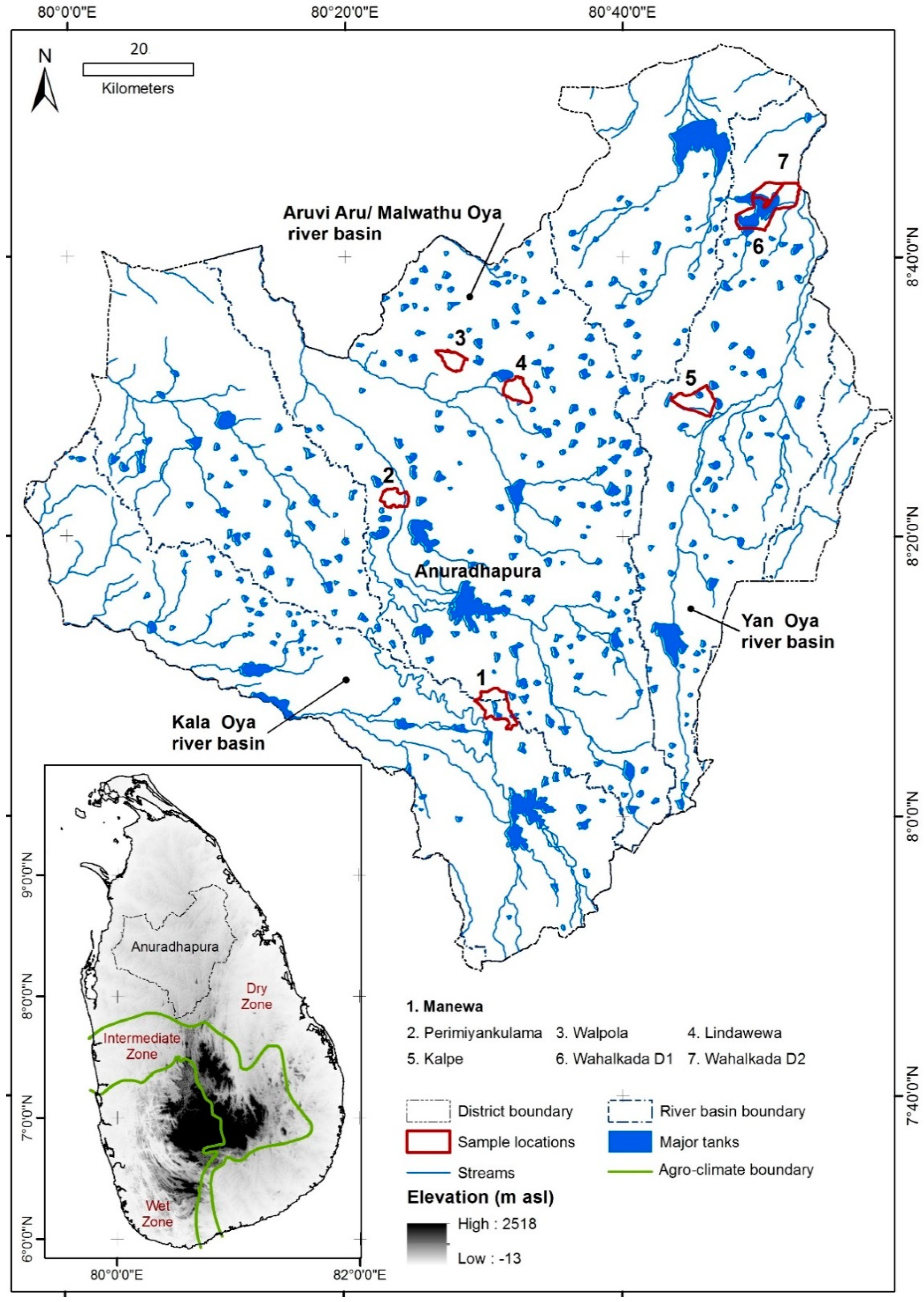
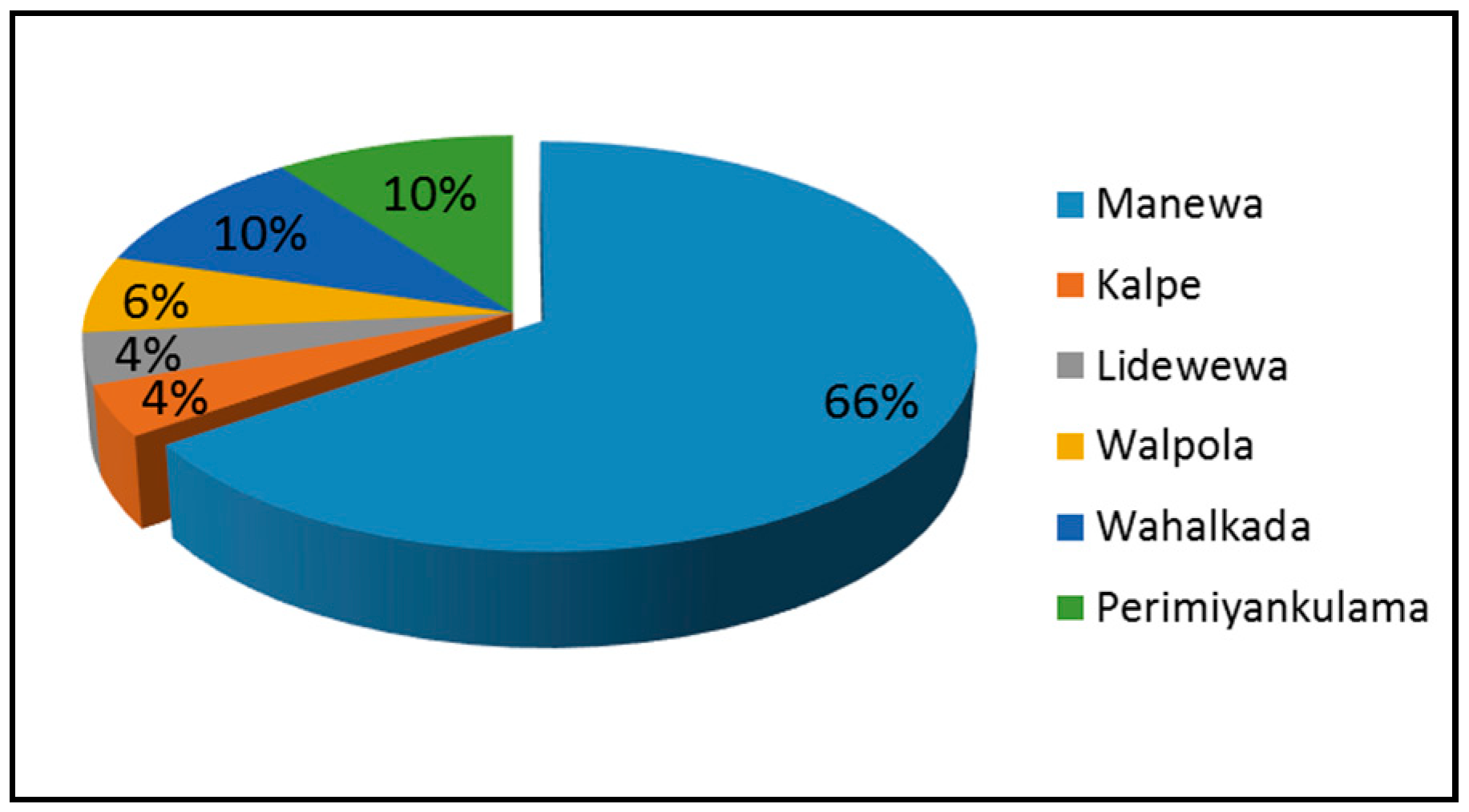
2. Materials and Methods

This study is based on semi-structured interviews with farmers who are participating in Farmer Organizations in the Anuradhapura district. Semi-structured interviews are used to understand the local farmers’ complex behaviors, opinions, emotions and effects as well as the diversity of experience [39]. The qualitative data received mainly focus on the farmers’ perceptions of the management of the irrigated landscape of the North Central Dry Zone and its preserved indigenous practices. Altogether, 49 interviews were conducted on two scales. On the macro level, seven Grama Niladari divisions (GN divisions/ the smallest administrative units at village level) located in the three major river basins around Anuradhapura (Malwathu Oya, Yan Oya and Kala Oya) were chosen and random samples were collected from each Grama Niladari division (Figure 1). Interviews with 111 questions of open, semi-open and closed character (see supplementary material) were used to capture the farmers’ perceptions of the management of their irrigated landscape and its indigenous aspects. Information from all the interviews was captured in a database for further analysis and coding.
A detailed survey was conducted within the village of Manewa situated in the Ipalogama Divisional Secretariat of the Anuradhapura district (Figure 1). A mixed-method approach [40,41] was used to collect a combination of qualitative and quantitative data sets within the detailed survey area. Besides the semi-structured interviews, field observations and participatory mapping [42] were conducted to record the indigenous agricultural system and current landscape management aspects within the Manewa village. Furthermore, geographic information system (GIS) mapping and a drone photographic survey were conducted to map the agricultural landscape of Manewa and the main components of the system were remodeled using the details in literature.
Descriptive statistical analysis was performed for the quantitative data. Quantitative and qualitative data were codified and compiled in a database; a thematic analysis was conducted based on question content analysis [43,44].
The results are presented, integrating macro- and microanalysis of the sample areas.

3. Results

Semi-structured interviews were carried out with 49 farmers from seven Grama Niladari divisions in the Anuradhapura district (Figure 1). The majority of the interviews (66%, n = 34) were conducted in the Manewa Grama Niladari division, while the remaining 15 interviews were spatially scattered over three different river basins in the Anuradhapura district (Figure 1 and Figure 2).
Almost all interviewees were male farmers. Age wise 45% (n = 22) of the interviewed farmers were 50–60 years of age, while 27% (n = 13) were aged over 60; 20% of the interviews (n = 10) were conducted with persons of 40–50 years old, while only 8% of the interviewees (n = 4) were 30–40 years old. Altogether, 57% of the interviewed farmers belonged to nuclear families, while the remaining 43% belonged to extended families. Only 10% (n = 5) of the interviewees had less than 15 years of experience in farming. In contrast, the majority of the interviewed farmers (37%, n = 18) had about 30 to 45 years of experience in irrigated agricultural farming; another 4% (n = 2) had more than 60 years of experience in agricultural farming. 65% (n = 32) of the interviewed farmers depend completely on agriculture for their livelihoods and only 35% (n = 17) had additional sources of income. Finally, only 31% (n = 15) of the interviewed farmers owned livestock.

3.1. Agricultural Practice in the North Central Dry Zone as Influenced by Indigenous Management

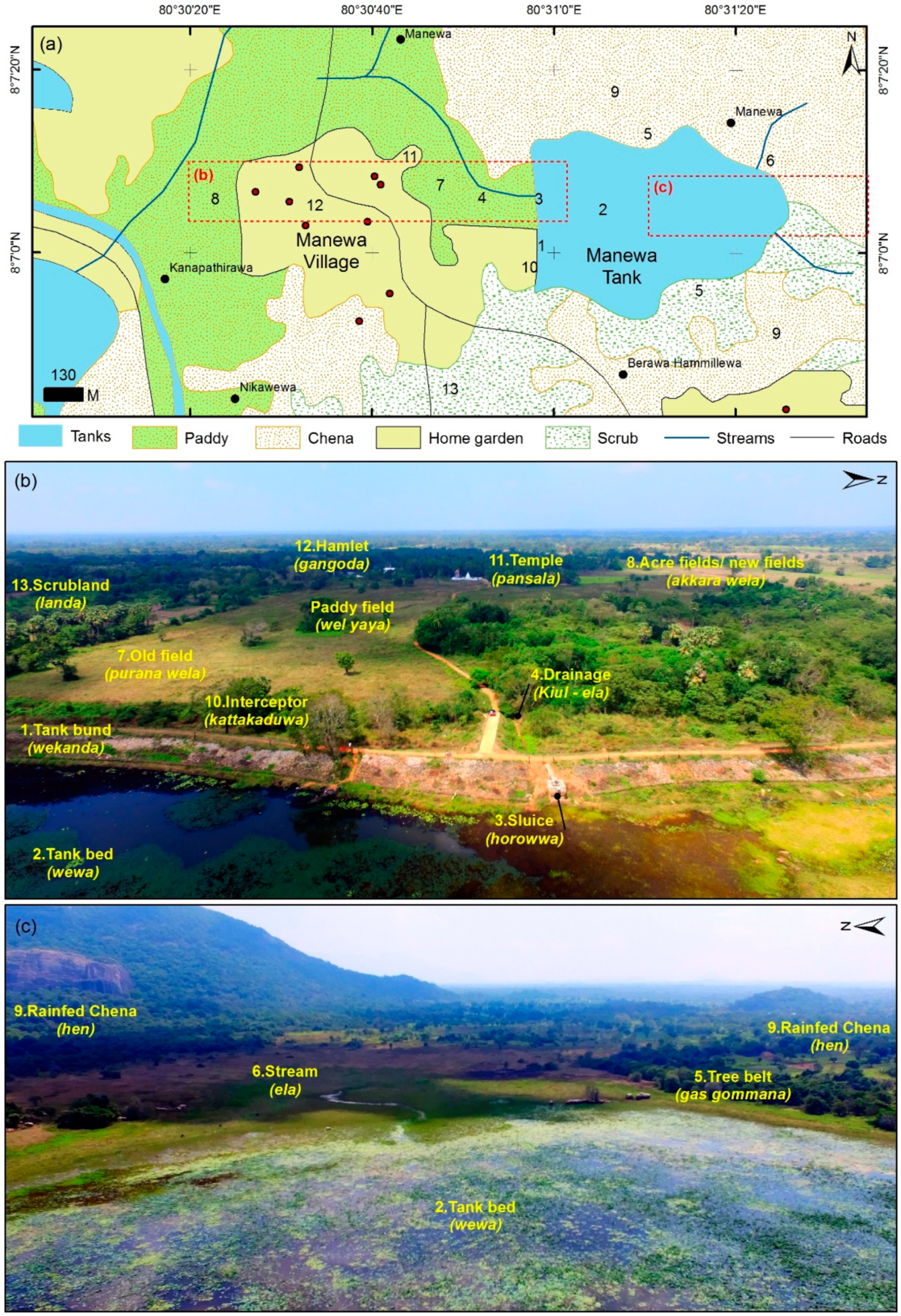
3.1.1. The Irrigated Landscape and the Agriculture System

Altogether 78% (n = 38) of the interviewees including the interviewed farmers from the detailed study at the village of Manewa conduct agriculture using major irrigation tanks, while only 11 farmers get irrigated water from minor irrigation schemes. All the farmers interviewed engage in paddy cultivation. Furthermore, 26 farmers of the 49 interviewed engage in slash and burn cultivation (chena). The data from the detailed survey conducted at Manewa confirm these findings with 17 farmers of the 34 interviewed engaging in chena cultivation. (See Figure 3).
During the detailed survey in the village of Manewa different components of the irrigated landscape were examined; some of the following segments are adopted from Dharmasena 2010 [35] (Figure 3). These major elements of the tank-irrigated agricultural system are managed in an integrated manner with certain indigenous practices and will be introduced in the subsequent sections.
(1).
Tank bund (Wekanda)—an earthen bund constructed to stop the runoff during the rainy season and so to collect the water for irrigation. The tank bund is the heart of the irrigated landscape.
(2).
Tank (Wewa)—stores the water and is the dominant feature of the landscape. Agriculture, livelihood and regular social behavior is intensely affiliated to the village tank.
(3).
Sluice (Horowwa)—uses a movable gate to control the outflow of water from the tank via canals and is integrated into the tank bund.
(4).
Drainage (Kiul Ela)—the natural valley system and its streams prior to the tank construction, existence based on the flow accumulation and erosion.
(5).
Tree belt (Gasgommana)—a natural vegetation strip in the upstream area of the tank that helps to reduce evaporation by acting as a wind barrier and helps to conserve the biodiversity of the tank environment. Large tree species such as Kumbuk (Terminalia arjuna) and Maila (Bauhinia racemose) are common in this segment.
(6).
Stream (Ela)—leads runoff water into the tank from the upstream headwater areas.
(7).
Old-field (Purana wela)—this is the command area of the tank, an originally paddy-cultivated field located in the valley bottoms downstream of the earth bund; it is associated with the ancient tank and the service tenants’ lands. Originally, the villagers owned this area communally as it is best supplied with irrigation water.
(8).
Acre field or leased fields (Akkara wela)—newly cultivated fields laid out after the British colonial irrigation and agricultural reforms. Private ownership is common. Supply of irrigated water is less favorable than in the old-fields.
(9).
Slash and burn/chena cultivation fields (hen)—fields with rain-fed agriculture that are located along the divide of the valley that hosts the tank.
(10).
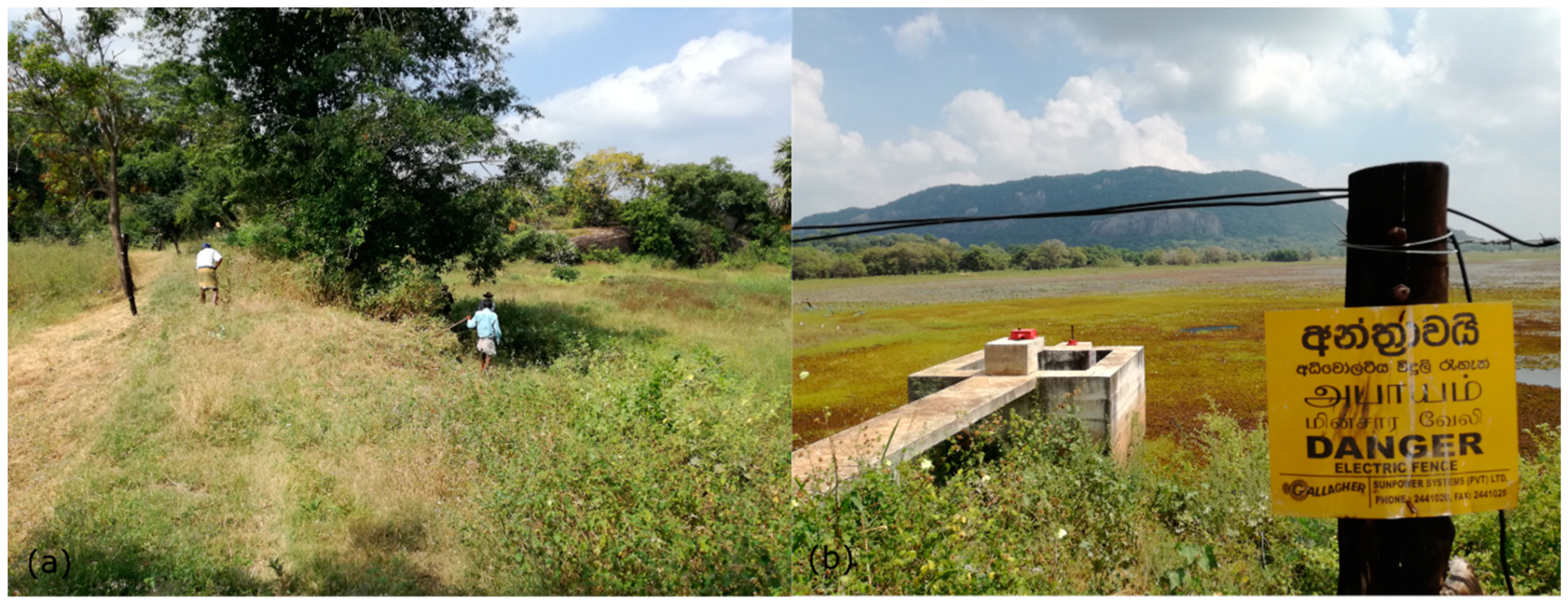
Interceptor (Kattakaduwa)—this area is located immediately downstream of the tank bund; it is densely vegetated with high species diversity. The main purpose is to prevent salt from entering the downstream paddy fields. Furthermore, it acts as a wind barrier.
(11).
Temple—is located in a focal position. Farmers organize main activities among themselves on this monastery land.
(12).
Hamlet (Gangoda)—a village located downstream of the tank close to the paddy fields.
(13).
Scrubland (landa).

3.1.2. Paddy Cultivation

All interviewed farmers engaged with irrigated paddy cultivation. All of them own farmland. In sum, 45% of the farmers (n = 22) own farmland between 1 and 3 acres. The same amount of farmers own 3 to 6 acres of paddy land and only 8% (n = 4) own paddy lands bigger than 6 acres. The majority of farmers (n = 46) conduct paddy cultivation in both Yala (April to August; dry season) and Maha (main season/ October to March; northeast monsoon). Only nine farmers interviewed cultivate crops like cereals or vegetables in their paddy lands when they do not get enough water for paddy cultivation.
The majority of the interviewed farmers used new high yielding varieties of seeds (with 3–3½ months of growth and ripening time). Sometimes they produce their own seeds, while mostly they buy the seeds from government institutions or local shops. Six farmers out of the 49 interviewed cultivate traditional paddy types such as kaluhinati, suwandal, malakada, murungkaya and kannimurunga. See Figure 4.
All interviewed farmers used fertilizers and pesticides for paddy cultivation (Figure 4). In total, 82% use artificial fertilizers and pesticides regularly for their paddy cultivation and only 6% use natural methods for fertilization and pest control regularly. Some of the natural methods used for plant protection, fertilization and pesticide control are:
  • Farmers allow cattle to graze in the paddy fields after the harvesting season. By this method cow dung and urine are used as fertilizers.
  • Green manure is added to the soil during the tillage process. This takes place when the terraced paddy fields (liyadi) are flooded with water after tilling and the vegetation debris from the cleared ridges in the paddy field and the rice straw mix with the water; in this manner a considerable amount of fertilizer is added to the soil.
  • Cutting up madu flower (cycus/Cycus circinalis) and placing the sliced pieces in several places and at the same level as the paddy for three days to deter particular insects. Some farmers burn the flowers to achieve an especially strong smell.
  • Chopped kohomba leaves (neem tree/Azadirachta indica) are used as pesticides: after being rinsed in a water basket for two weeks they then spread over the paddy fields.
  • Chopped kala wel (Derris canarensis) and chopped gliricidi (Gliricidia sepium) are spread over the paddy field to prevent worm infestations.
  • Chopped nawahandi (cactus/Rhipsalis baccifera) is spread in the paddy fields to prevent plant worms.
  • Chopped and raw papaya fruit is spread to control rats.
  • In addition, kem, a secret treatment, is practiced; this is characterized by a number of actions which are believed to be followed by certain reactions. These methods differ according to the individual applying them and are transferred as part of indigenous knowledge.
As well as these physical methods, astrological practices are also used locally; thus farmers follow astrology to determine the timing of activities such as trampling, ploughing and harvesting. Buddhist pirith chanting is also used to bless the successful harvest and to avoid trouble by disasters. In individual cases the use of black magic was emphasized. See Figure 5.
All interviewed farmers use machinery such as tractors for trampling and combine harvesters for harvesting. However, they still practice traditional soil management techniques for paddy cultivation (Figure 5), including a tillage process and soil conservation. None of the farmers use the traditional plough for tillage. Two main measures for soil conservation are the soil ridge (niyara) and bench terrace (liyadda). Soil ridges are used to prevent soil erosion within the paddy field. Farmers use two main ridges to frame a field on two sides, combined with lower ridges arranged at right angles to the main ridges (dik niyara). To prevent surface flow and thus wash out, several openings (wakkada) are placed between the two ridges. Bench terraces (liyadda) are placed in between the ridges for paddy cultivation. Various types and shapes of terraces such as regular, crisscross and line shapes are used in the village of Manewa (Figure 5) to manage the spaces and optimize soil erosion prevention.
Besides, paddy farmers practice an indigenous and sustainable management method called Bethma govithana to prevent abandonment of the paddy field in poor rainfall seasons. In insufficient rainy seasons, in the past under the guidance of Vel Vidane and currently with the Farmer Organizations, they divide the upper command area of the old-field (purana wela) (Figure 3) close to the tank bund into equal portions and distribute these areas among the original farmers (who inhabit the village ancestrally) for cultivation with the limited amount of water available in the tank. The main objective of the bethma govithana is to achieve a harvest to enable subsistence and preserve seeds for the next cultivation period.
The majority of the interviewed farmers confirmed the occurrence of crop failures during the last 10 years (n = 45). Around half of the interviewed farmers mentioned crop failures due to animals, mainly elephants (51%). Around 45% of the interviewed farmers referred to climatic conditions affecting crop failures, mainly due to droughts or flooding. Only 3% of the interviewed farmers referred to plant diseases as reasons for crop failures.

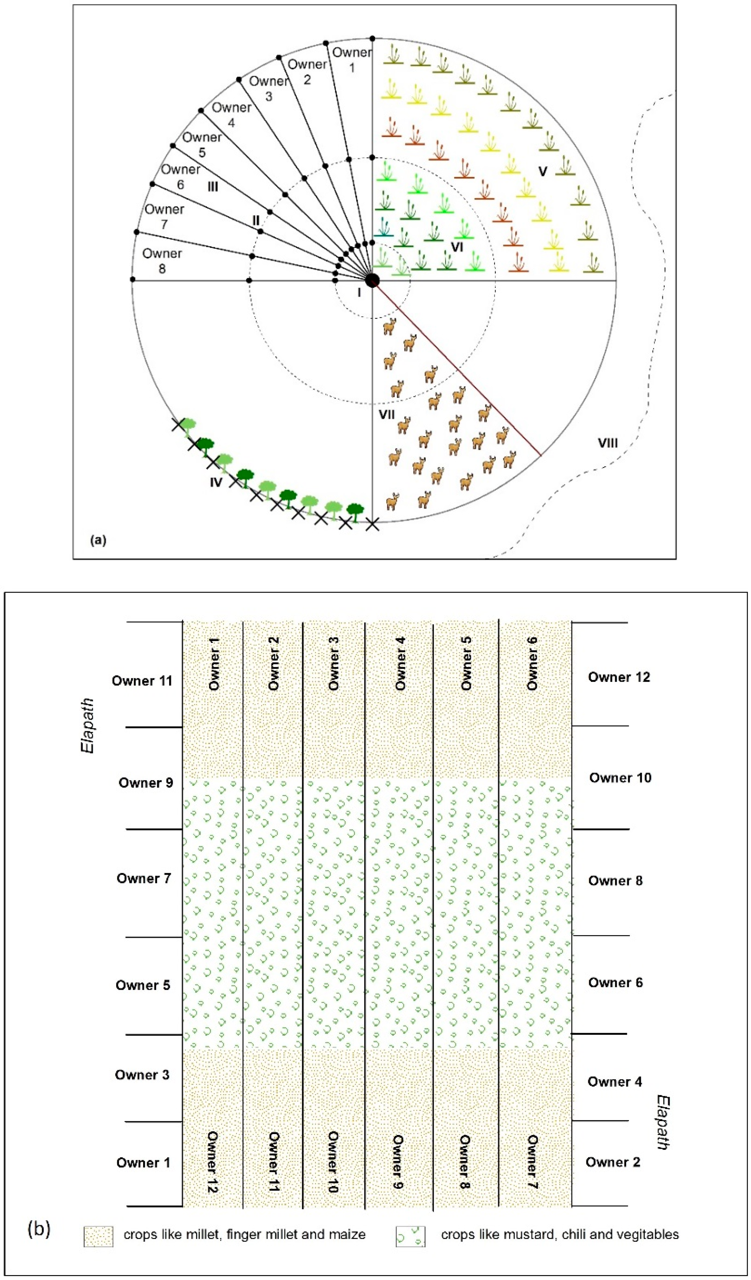
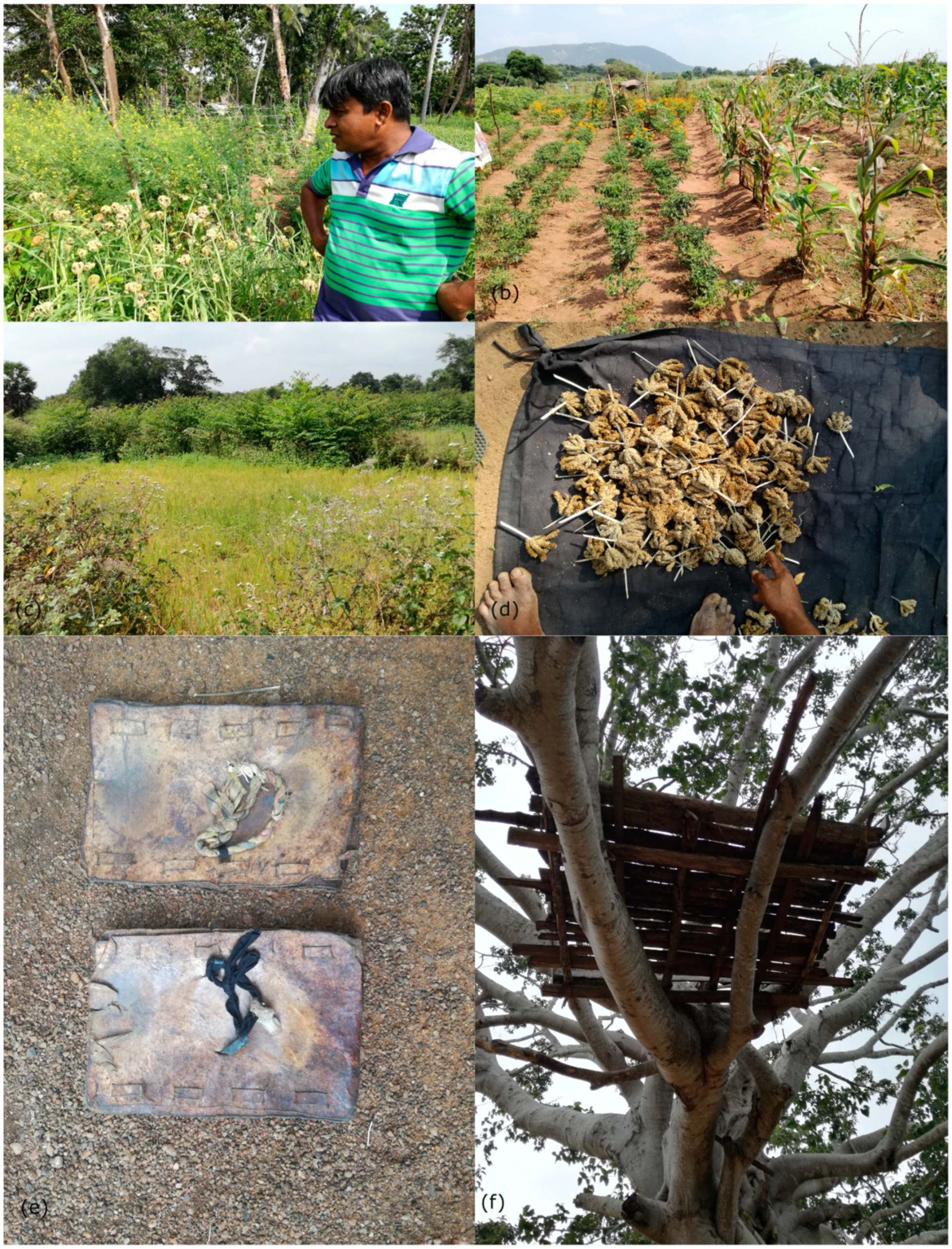
3.1.3. Slash and Burn/Chena Cultivation

In total, 53% of the farmers interviewed engage in rain-fed chena cultivation. Chena was cultivated in the areas where irrigation is not possible. Among the interviewed farmers, Maha henchena cultivation in the main rainy season—is popular. Only six farmers of the 26 practicing chena engage in Yala henchena cultivation in the minor rainy season. In general, chena cultivation starts in July or August every year. Chena cultivation is still practiced applying the inherited indigenous methods (Figure 6 and Figure 7), including land preparation, organization and plant protection. Furthermore, chena cultivation was in most cases conducted as a collective farming method. The various processes of chena cultivation usually start with clearing the ground by cutting and burning the debris of existing vegetation. The soil layer is then raked and seeds are sown. After several chena cycles the field is abandoned due to the decline of soil fertility. According to the interviewed farmers, gingerly (thala), mustard (aba) (Figure 7a), finger millet (kurakkan) (Figure 7a), mung beans, cowpeas (kawupi) and highland paddy (Figure 7c) are usually sown for chena. Furthermore, they cultivate several vegetables such as bitter gourds, beans, onions, chilies, long beans, eggplants, pumpkins and tomatos as part of chena (Figure 7b). Most recently, maize (Figure 7b) has become increasingly popular among many farmers as a cash crop for chena cultivation.
Based on the way land was cleared and the overall land management, several types of chena cultivation have been identified. The majority of the interviewed farmers engage in isolated chena (thani hen) or a series of interconnected chena plots (yaya hen). The detailed survey in the village of Manewa show that here the inhabitants still practice some indigenous, sustainable types of chena such as wheel chenas (mulketa hen) and line chenas (elapath hen/irivili hen) (Figure 6). In both cases the practicing of chena cultivation ensures less crop failure for the individual farmer.
  • Wheel chena (mulketa hen) (see Figure 6a): after selecting suitable forestland the farmers divide the land into a cartwheel shape using a permanent landmark (mulketaya) in the center, usually a tree. Each portion is allocated to an individual farmer who participates in the chena cultivation. The farmers enclose the chena land using a strong fence (danduweta) created by bending and binding natural vegetation in the distal part of the mulketa hen this measure especially aims to provide protection from wildlife. For each sector the farmer decides which crop will be planted based on traditional knowledge and experience.
  • Line chena (elapath hen, Irivili hen) (see Figure 6b): land management is practiced in a linear manner; also here, the decision as to which crops will be planted is based on traditional knowledge and experience.
Compared to paddy cultivation, farmers use less fertilizer for chena cultivation and mainly depend on the natural soil-fertility. In total, 50% of the interviewees rarely use artificial fertilizers and pesticides for chena cultivation as the harvest is mainly used for their own consumption. The majority of the interviewed farmers depend on strategic or secret practices (kem) as plant protection systems. Furthermore, each chena field has a tree house and the farmers stay there overnight to protect the harvest from animals, most likely elephants (Figure 7f). All 26 interviewed farmers practicing chena mentioned crop failures due to elephants during the last 10 years; 11 of them additionally refer to climatic reasons for crop failure while only two farmers mentioned harvest loss due to plant diseases.

3.1.4. Agricultural Rituals

A number of rituals were identified as occurring as part of the Dry Zone irrigation landscape and agricultural resource management. Most of these rituals are conducted as collective efforts led by the elders of the village, astrologers or priests of the temple. Nowadays, Farmer Organizations initiate the rituals, while in earlier times the local agricultural chief “Vel Vidane” took the initiative. Government institutions such as the Agrarian Service Department and the Irrigation Department also take part in the ceremonies. Throughout the study area two major ritual festivals are linked with irrigated agriculture:
  • Pot ceremony (Mutti mangallaya): this ceremony is performed annually when the village tank overflows in the rainy season. With this ritual, the tank and the village dedicate to the village god (Gambara) and pray to him to protect the tank from damage and the village from flooding.
  • Milk pot ceremony (Kiri ithiraveema): this is an annual ceremony practiced by the farmers in the tank after the harvest. The beginning of the farming activities for the new season is symbolized by a milk pot set up close to the tank.
Beside these two main community rituals or ceremonies, individual farmers practice a number of rituals based on astrological practices, secret beliefs (black magic) and secret strategic interventions (kem) and Buddhist beliefs.

3.2. Irrigation and Water Management Framework

3.2.1. Early Initiative—The Vel Vidane System

Before the implementation of the Farmer Organization system, village agriculture and water management activities were undertaken by the headman system called Vel Vidane. Details of the responsibilities and the sustainability of this previous system were examined during the detailed survey in the village of Manewa. Only three farmers of the 34 interviewed from Manewa were not aware of this previous system. Furthermore, 71% of the farmers interviewed in Manewa (n = 24) prefer the previous Vel Vidane system to the present Farmer Organization system. According to the farmers interviewed, Vel Vidane was a hereditary position and was considered as the head of the village and the village tank. Furthermore, it was a volunteer position. For his service the Vel Vidane received a share of the harvest called “salaris” from each farmer, corresponding to one quarter of the bushel of harvest. The Vel Vidanes’ main responsibilities included:
  • Leading and coordinating the maintenance of the tank. The maintenance of the tank bund was based on a system called “Pangu Katti”. The Vel Vidane measured the tank bund and divided it (wekande pota bedima) by a local measure into units called bamba or fathoms (equal to six feet). Based on the size of the paddy land the farmers owned, they were each allocated a portion of the bund for maintenance. This they had to clean by removing termite houses and repairing damage caused by cattle herding. To strengthen the tank bund, sediments from the tanks were used and placed on both flanks of the tank bund.
  • Opening and closing the sluice gate as required.
  • After the rainy season, the Vel Vidane decided on the type of seeds and the cultivation schedule for each season.
  • Preparing the schedule for constructing soil management ridges and terraces (Niyara and liyadi) in the paddy fields.
  • Preparing the water schedule for paddy field irrigation.
  • Preparing schedules for the harvest protection measures such as fencing and security points (murapal). The Vel Vidane divided the entire paddy field into sectors and decided how many security points were needed to protect the harvest from animals. He had to create schedules for the construction of these security points and for the number of days each farmer had to remain there for vigils. The work was allocated according to the size of the paddy field each farmer owned.
  • The Vel Vidane had to decide on the dates for main agricultural events such as ploughing and harvesting. He initiated these activities with the related rituals and customs.
  • After each season’s harvest, the Vel Vidane arranged fishing in the entire tank and distributed the fishing harvest to each household in the village.
  • Furthermore, his responsibilities included the organization of other common services in the village such as cleaning the villages and cleaning the roads to the village.
According to the interviewees, the Vel Vidane system helped to conduct irrigation agriculture as a collective effort participated in by the whole village. The whole village functioned and obeyed the verbal orders of the Vel Vidane.

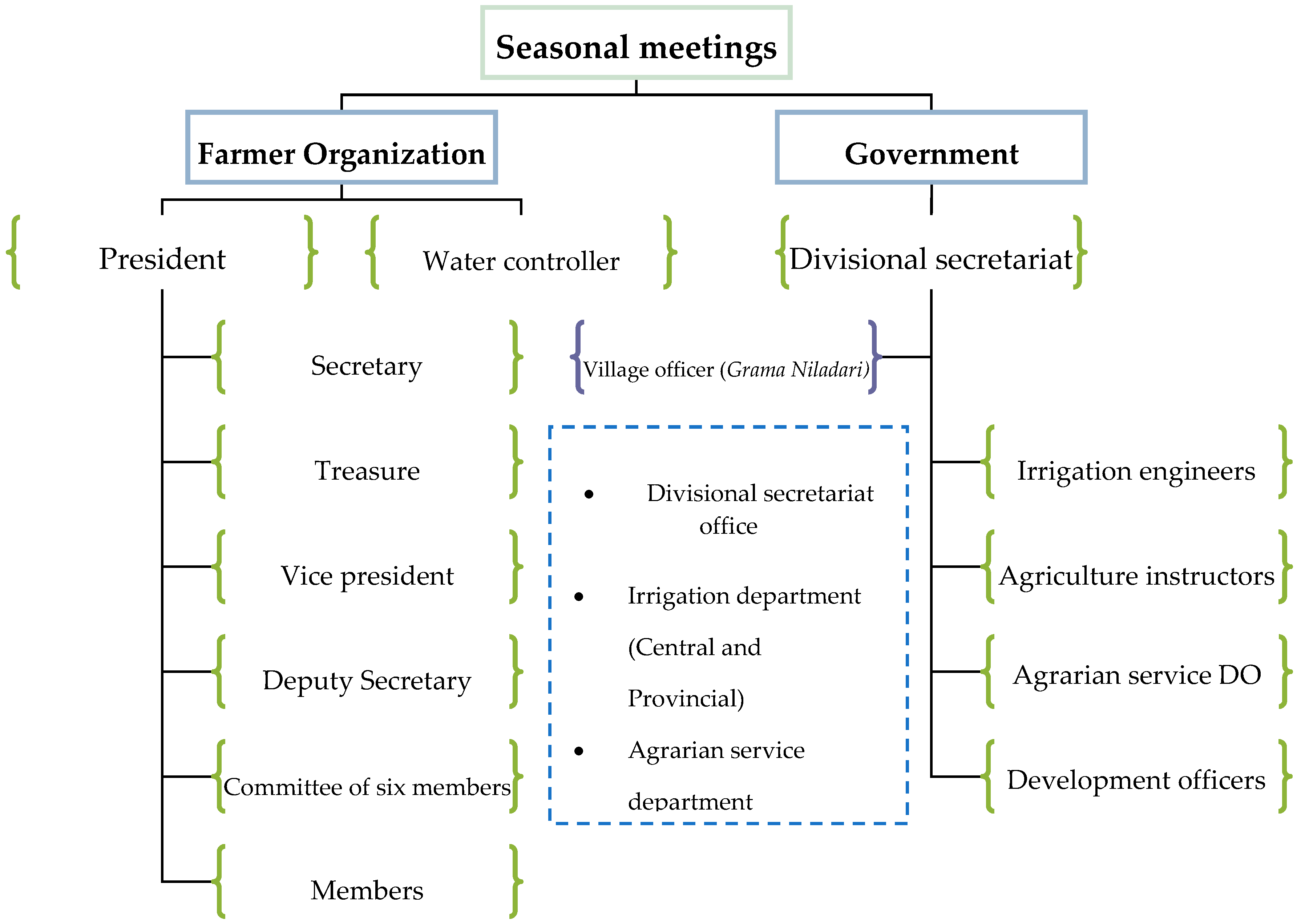
3.2.2. Current Management Structure

Under the current management structure, irrigation infrastructure management and water management is conducted in two different ways in major irrigation schemes: the Governmental Irrigation Department undertakes the maintenance measures for the tanks and channels, while water and agricultural management is implemented by a combination of governmental and communal Farmer Organization initiatives. Maintenance decisions are exclusively taken by the engineers and technicians from the Governmental Irrigation Department. However, from time to time, the government hires labor from the villages through Farmer Organizations for cleaning and some maintenance activities (Figure 8a). In hazardous situations in particular, villagers contribute to the process through a volunteer labor system called “shramadana”.
Within the group of interviewees, all farmers participated in Farmer Organizations. Out of the 49 interviewed farmers 44 were ordinary members, two interviewees were board members, one interviewee held a prominent position on the board of a Farmer Organization as head, one as secretary, and one as treasurer. According to the farmers interviewed, recommendations by the government regarding the use of fertilizers are provided through the Farmer Organization and are a major attractor for joining the Farmer Organizations (Figure 9). Other major benefits of joining are receiving the irrigation water, compensation for crop failures and expert instructions from the government officials through Farmer Organizations.
According to the statements provided by the interviewed farmers, the board members of Farmer Organizations are annually elected by the members. Main positions include the president, vice president, secretary, deputy secretary, treasurer, and an advisory committee of six members. The previous Vel Vidane post has been replaced by the post of the water controller, whose responsibilities are limited to the operation of the sluice gate and distribution of the irrigation water. Communication in Farmer Organizations is mainly organized through meetings. Each season they have a general seasonal meeting (kanna rasweema) to organize the irrigation strategy for the season. Besides, they may have additional meetings under special circumstances. Various officers of government departments also regularly participate in these meetings of the Farmer Organizations (Figure 10). According to the farmers interviewed, the head of the organization issues invitations to meetings and asks government officials to participate. Meetings are led by the head of the organization and decisions are taken in a collective manner.
Decisions on matters related to irrigation agriculture are taken collectively. Government officials consult and provide recommendations, while the decisions are taken by the farmers’ votes; for decisions a majority of 2/3 of the votes is required. The farming community formulates the solutions and ideas for each issue and the president implements the decision and provides counsel to the members during realization. In general, decisions on the use of irrigation water, the types of seeds to be used, the cultivation periods, fertilizer benefits and loan schemes for farmers are taken at seasonal meetings. In total, 41% of the interviewed farmers are highly satisfied with their Farmer Organization, while 10% are unsatisfied; 49% of the interviewed farmers were indecisive about whether they were satisfied or unsatisfied with the work of their Farmer Organization.

3.2.3. Issues and Constraints

The interviewed farmers introduced a number of issues concerning current management practice. Some farmers mentioned poor interventions in irrigation infrastructure by the professionals and engineers and too little integration of the farmers’ knowledge and experiences into such decisions. As an example, farmers in the village of Manewa face many difficulties due to such decisions. Thus in previous times the chena cultivation was an integral part of the tank village life and indigenous agricultural system. Due to governmental interventions the farmers are now subject to many restrictions arising from wildlife policies. Most recently, the Wildlife Department put an elephant fence on a tank bund surrounding the entire tank (Figure 8b). In consequence, ancient chena lands were included in a wildlife sanctuary and farmers had restricted access. These unaligned courses of action severely influence the livelihoods of the farmers as well as the balance of the landscape.
Farmers in Manewa also highlighted that the government officers are rarely concerned with farmers’ views and indigenous management practices. According to the farmers, this poor management combines with environmental problems such as dry periods or droughts to cause crop failures. Most farmers in Manewa mentioned that they did not get enough rain to cause the tank to overflow during the last four years. However, 82% of the interviewed farmers were satisfied with the irrigation maintenance by the irrigation department, 18% were unsatisfied.
The popularization of cash crops such as guava causes many difficulties for the traditional farming community and the landscape balance because the guava farmers use the land and water resources of the villages but at the same time remain outside the collective farming activities. Changing land use activities also changes the behavior of wildlife. Furthermore, farmers mentioned some political influencing of decisions within the Farmer Organizations. The majority of the farmers suggested that the sustainable link between the village and its environment was degraded by the transformation from the Vel Vidane system to Farmer Organizations.

4. Discussion

The focus of the current study is on the transformation of irrigated agricultural systems in Sri Lanka’s North Central Dry Zone and assessment of the sustainability of these measures. The analysis is based on semi-structured interviews conducted in the Anuradhapura district. The dry zone hydraulic civilization started to flourish during the ancient Kingdom of Anuradhapura in the area around its capital Anuradhapura [7] and until today inhabitants continue irrigation agriculture with the ancient irrigation infrastructure.
The selection of Grama Niladari (GN) divisions for random sampling is justified by two factors. Firstly, selected areas are located in three major river catchments in the Anuradhapura district (Figure 1) which are interconnected with wide irrigation infrastructure dating back to the Kingdom of Anuradhapura. Secondly, Divisional Secretariat (DS) divisions with highly populated (Madewachchiya and Nuwaragam palatha central DS divisions) and averagely populated (Horowpothana and Ipologama DS divisions) farming communities were also considered (Table 1). The selection of the village of Manewa for detailed observation is based on its comparatively isolated rural location in the Anuradhapura district, where the peasants continue to practice an indigenous agricultural system to a certain degree. All of the farmers interviewed were male—which is a common phenomenon in the entire Dry Zone area. In the Anuradhapura district, 83% of farmers were male at the time of the 2013/14 economic census (Table 1). It is remarkable that none of the interviewed farmers is younger than 30 years—a phenomenon that also corresponds to the data of the 2013/14 census and documents the rural depopulation especially of young people (Table 1).
Over the last decades, many authors have highlighted indigenous knowledge as being central for sustainable development [45]. According to the FAO initiative Globally Important Agricultural Heritage Systems, nearly 5 million hectares of lands are still covered with agricultural heritage systems worldwide [29]. Especially in the Asian context, many traces of community-driven indigenous irrigation practices such as the Ifugao rice terraces in the Philippines, the subak system in Bali, Indonesia and the Hani rice terraces in China are preserved and highlighted [29,46]. The wewas or the tank-based village irrigation agricultural systems in Sri Lanka are discussed here as another example of a sustainable indigenous resource-use system inherited from ancient times. Comparable indigenous water management systems are also known from India. According to Gunnel et al. [47], small reservoirs or tanks predominantly supplied by surface runoff, as opposed to river canals, have for centuries dominated an entire agrarian civilization, especially in southern India. Furthermore, they document that village communities have taken advantage of the potential for surface and subsurface runoff harvesting by developing the tank system [47].
The results from the interviews of farmers from the area around Anuradhapura show that the spatial organization and majority of the salient features of the typical Dry Zone irrigated agricultural landscape in Anuradhapura are unchanged and their indigenous characteristics are widely preserved (Figure 3 and Figure 11). The land use and the basic ecological elements represent a unique human-eco-system, which accomplished continuous land use with a remarkable degree of stability [49]. Basic land use types such as paddy and chena cultivation were managed in an interconnected manner (Figure 3, Figure 5 and Figure 6). Irrigated land use was directly linked with the socio-cultural behavior of the villages, underlined by the farmers’ perceptions of their landscape. The land tenure of the Dry Zone agricultural system is still characterized by the indigenous system comprising the old-field (purana wela), acre/leased fields (akkara wela) and chena lands under communal ownership, (Figure 3) similar to the Pul Eliya village examined by E.R. Leach in 1959 [17,31]. In consequence, it can be concluded that few changes have affected the traditional agricultural setting during the past five decades. Furthermore, indigenous measures taken to minimize vulnerability to drought, such as bethma govithana, examined by Bordie in 1856 [50], have been practiced by the villagers from Manewa over the centuries and are still in use. Regarding the technical aspects of irrigation agriculture, it is shown that the paddy farmers still practice indigenous landscape management, soil conservation and management technologies such as soil ridges (niyara) and bench terraces (liyadi) (Figure 5). In terms of cultural norms, parts of the agricultural community still practice belief systems, rituals and customs integrated with agriculture in a collective manner.
Despite the preservation of many traditional characteristics numerous changes in the agricultural system were also identified. With the introduction of “Green Revolution” initiatives, traditional types of paddy were replaced by high yield varieties of seeds. Of the 49 interviewed only six farmers reported that they still cultivate traditional paddy types. As an unavoidable consequence farmers also had to shift from indigenous plant protection systems to artificial fertilizers and pesticides. Furthermore, the use of heavy machines like tractors and combine harvesters were introduced, while simultaneously traditional methods such as ploughing and harvesting with buffaloes were abandoned; in fact, all of the interviewed farmers used machines and artificial fertilizers and pesticides. However, the paddy statistics for the last three decades do not show a significant improvement in agricultural production with the introduction of new technologies (Figure 12), even though the paddy area cultivated has been increased [48]. The same statistical report provides evidence that gross production is predominantly controlled by external factors such as availability of water, natural disasters and the political conditions of the country [48]. Further, it can be assumed that the ongoing use of agro-chemicals and pesticides will have an impact on the health of the farmers [52].
Based on the long duration of its application, it can be assumed that the indigenous agricultural system was a sustainable land use system integrating natural resources, irrigated paddy cultivation, chena and village life (Figure 3). The cultural and ecological dimensions of the system were blended and interdependent. With the late 20th century agriculture and management reforms, the land management system lost resilience and became more vulnerable especially to environmental impacts [16]. The detailed survey from the village of Manewa shows that here the agricultural community faces various challenges due to political and institutional decisions being made without considering local, indigenous knowledge. The most recent forest and wild life policies have suddenly restricted access to the chena fields of farmers practicing traditional chena cultivation; in the past these fields were an integral part of their agricultural system. In addition, the indigenous agricultural system is in danger due to population pressure, for instance, in 1981 population density in Anuradhapura was 82 per km2 and in 2012 it had reached 128 per km2 [48]. On the other hand, modernization, market changes and educational developments increasingly cause migration from the rural zones into the cities and the abandonment of small-scale farming. The lack of young farmers among the interviewees is an indicator for the lack of attractiveness of small-scale farming for the young generation. In the current sample the majority of interviewed farmers are middle aged and elderly.
The results make evident that various changes accompanied the transformation of the Vel Vidane management system to a community-based Farmer Organization system. Throughout the world, participatory management of irrigation and water resources have been highlighted and subjected to experiments in recent decades [54,55,56]. Similarly, the Sri Lankan Government tried to implement community participation in irrigation management by adopting a policy of transforming responsibility for the operation and maintenance of the irrigation facilities; this included making the Farmer Organizations responsible for the maintenance of the distribution canals downstream of the tanks in 1988 [36]. Considerable research has been conducted to measure the effects of this transformation from economic and management perspectives [36,37]. According to M. Samad and others in 1999, this management transfer alone did not bring significant changes in the quality of the irrigation services and agricultural production [36]. Based on our results we argue that, even though Farmer Organizations added bottom-up approaches and inputs with community participation for the management of the agricultural landscape, the integral and spiritual bond with the landscape was lost with the transformation from the indigenous Vel Vidane system to the Farmer Organization system. It is obvious that at present the majority of the farmers join the Farmer Organizations to get recommendations concerning the fertilizers to be used and to receive other benefits from the government, instead of the spiritual bond they had earlier with the indigenous system.

5. Conclusions

Throughout the world, for millennia people developed locally adapted agricultural systems. These “indigenous” agricultural systems were highly based on traditional knowledge and were continuously adapted to changing environmental, social and political conditions; they represent local knowledge, forming a vital combination of social, cultural, ecological and economic services to humankind [29]. Unlike modern agricultural technologies, indigenous methods often addressed the efficient utilization of resources and helped to preserve cultural diversity and biodiversity with collective involvement. The Sri Lankan small tank cascade systems are an example of such an indigenous agricultural system. They were initiated in the heydays of ancient kingdoms and since then have undergone several transformation processes. In the 1960s, these processes were triggered by the Green Revolution. Until the Green Revolution the basic elements of the indigenous system and the main ecological and socioeconomic components of the landscape were widely preserved. Current research suggests that these basic elements of the landscape still exist and function to a certain degree despite the forces of modernization, population pressure, economic changes and educational development.
The management structure and mechanisms were changed from the hereditary headman system to a community-based Farmer Organization system. The transformation into a participatory approach seems a productive and attractive evolution of the system. However, the in-depth analysis of the perception of the main stakeholders of the systems—the farmers—revealed that the inseparable bond they had with the landscape and the entire agricultural system was threatened by the current Farmer Organization system: the spiritual connection was converted into a financial and benefit-oriented system. Within the previous Vel Vidane system, the farmers directly participated in the tank maintenance and holistic management of the village tank landscape with its irrigation agriculture. In contrast, within the current Farmer Organizations system the farmers contribute to the maintenance as daily laborers. With the onset of the Farmer Organizations system the farmers became increasingly alienated from the landscape, leading to the deterioration of the indigenous agricultural system.
The case study demonstrates the value of preserving indigenous agricultural systems and the negative outcomes of the current management interventions that neglect the indigenous system. Therefore, careful interventions and innovations are needed to adapt the tank-based indigenous agricultural systems of the Dry Zone of Sri Lanka so as to preserve ecological and socio-economic sustainability.

Supplementary Materials

The following are available online at https://www.mdpi.com/2071-1050/11/3/910/s1.

Author Contributions

Author Contributions: All authors: conception of the paper, N.A. and T.W.: data acquisition, N.A. data analysis, writing of original draft; W.B. and B.S. supervision, and writing–review and editing, funding acquisition.

Funding

This research was funded by the Volkswagen Foundation grant number 88578.

Acknowledgments

We sincerely thank the Volkswagen Foundation for funding this study as part of the joint research project “Tank cascade systems as ancient measures of integrated Watershed Managements in the Dry Zone of Sri Lanka” between the Freie Universität Berlin and the University of Peradeniya (Project-ID: 88578). Furthermore, we are grateful to Indika Alahakoon for the photograph. We thank Kathrine Thomas for professional English proof reading.

Conflicts of Interest

The authors declare no conflict of interest.

References

  1. International Water Management Institute. Multiple Uses of Water in Irrigated Areas: A Case Study from Sri Lanka; IWMI: Colombo, Sri Lanka, 1999; ISBN 978-92-9090-380-2. [Google Scholar]
  2. Dawson, N.; Martin, A.; Sikor, T. Green revolution in sub-Saharan Africa: Implications of imposed innovation for the wellbeing of rural smallholders. World Dev. 2016, 78, 204–218. [Google Scholar] [CrossRef]
  3. Farmer, B.H. Green Revolution: Technology and Change in Rice-Growing Areas of Tamil Nadu and Sri Lanka; Macmillan Publishers Ltd.: London, UK, 1977; ISBN 978-1-349-04938-7. [Google Scholar]
  4. Sandell, K. Farmers’ Eco-Strategies with Regard to Water, Nutrients and Sustainability: A Case-Study of Low-Resource Agriculture in the Dry Zone of Sri Lanka. Geogr. Ann. Ser. B. Hum. Geogra. 1993, 75, 163–176. [Google Scholar]
  5. Abeywardana, N.; Bebermeier, W.; Schütt, B. Ancient Water Management and Governance in the Dry Zone of Sri Lanka Until Abandonment, and the Influence of Colonial Politics during Reclamation. Water 2018, 10, 1746. [Google Scholar] [CrossRef]
  6. Bandara, C.M. Catchment Ecosystems and Village TankCascades in the Dry Zone of Sri Lanka A Time-Tested System of Land and Water Resource Management. In Strategies for River Basin Management; D. Reidel Publishing Company: Dordrecht, The Netherlands, 1985; pp. 99–113. [Google Scholar]
  7. Gunawardana, R.A.L.H. Irrigation and Hydraulic Society in Early Medieval Ceylon. Past. Present 1971, 53, 3–27. [Google Scholar] [CrossRef]
  8. Brohier, R.L. The Story of Water Management in Sri Lanka Down the Ages: Food and the People; Sooriya Pub.: Colombo, Sri Lanka, 2006. [Google Scholar]
  9. Department of Census and Statistics. Paddy Statistics, 2017 Yala Season; Department of Census and Statistics: Colombo, Sri Lanka, 2018.
  10. Dahdouh-Guebas, F.; Hettiarachchi, S.; Seen, D.L.; Batelaan, O.; Sooriyarachchi, S.; Jayatissa, L.P.; Koedam, N. Transitions in ancient inland freshwater resource management in Sri Lanka affect biota and human populations in and around coastal lagoons. Cur. Biol. 2005, 15, 579–586. [Google Scholar] [CrossRef] [PubMed]
  11. Sakthivadivel, R.; Fernando, N.; Panabokke, C.R.; Wijayaratna, C.M. Nature of Small Tank Cascade Systems and a Framework for Rehabilitation of Tanks within Them; International Irrigation Management Institute (IIMI): Colombo, Sri Lanka, 1996; ISBN 978-92-9090-324-6. [Google Scholar]
  12. Panabokke, C.R. Small Tanks in Sri Lanka: Evolution, Present Status, and Issues; IWMI: Colombo, Sri Lanka, 2002. [Google Scholar]
  13. Jayasena, H.A.H.; Chandrajith, R.; Gangadhara, K.R. Water management in ancient Tank Cascade Systems (TCS) in Sri Lanka: Evidence for systematic tank distribution. J Geol. Soc. Sri. Lanka 2011, 14, 29–34. [Google Scholar]
  14. Eriyagama, N.; Smakhtin, V.; Chandrapala, L.; Fernando, K. Impacts of Climate Change on Water Resources and Agriculture in Sri Lanka: A Review and Preliminary Vulnerability Mapping; IWMI: Colombo, Sri Lanka, 2010; ISBN 978-92-9090-727-5. [Google Scholar]
  15. Mahaweli Diversion Scheme Experience in Integrated Water Resource Integrated Water Resource Management; (Report) Mahaweli Authority: Colombo, Sri Lanka, 2018.
  16. Shah, T.; Samad, M.; Ariyaratne, R.; Jinapala, K. Winds of change in ancient irrigation civilization of Sri Lanka’s north central dry zone. IWMI-Tata Water Policy Res. High. 2012, 21, 7. [Google Scholar]
  17. Leach, E.R. Hydraulic Society in Ceylon. Past Present 1959, 15, 2–26. [Google Scholar]
  18. Geiser, U. Indigenous Resource Management and External Development Interventions in the Dry Zone of Sri Lanka: From Conflicts to Synergies? Geo. J. 1995, 35, 185–196. [Google Scholar]
  19. Karunanada, U.B. Nuwarakalawiya and the North Central Province under British Administration 1833–1900; Research Centre for Social Sciences, University of Kelaniya: Kelaniya, Sri Lanka, 2006. [Google Scholar]
  20. Giragama, W.M.G.; Sanker, M.S.S.; Samarakoon, S.M. Development and Strengtheningof Farmer Organizationsthrough Farmer Conventions; Final Evaluation Report on the Impact of Farmer Conventions held in Anuradhapura and Matale Districts; Hector Kobbekaduwa Agrarian Research and Training Institute: Colombo, Sri Lanka, 1999. [Google Scholar]
  21. van der Molen, I. Rains, Droughts and Dreams of Prosperity: Resourceful Strategies in Irrigation Management and Beyond: The Sri Lankan Case. PhD Thesis, University of Twente, Enschede, The Netherlands, 2001. [Google Scholar]
  22. Somasekaram, T. The National Atlas of Sri Lanka; Sri Lanka Survey Department: Colombo, Sri Lanka, 1988; pp. 1–141. [Google Scholar]
  23. International Water Management Institute. Water Information System for Sri Lanka. Available online: http://slwater.iwmi.org/ (accessed on 12 December 2018).
  24. Grenier, L. Working with Indigenous Knowledge: A Guide for Researchers; IDRC: Ottawa, ON, Canada, 1998; ISBN 0-88936-847-3. [Google Scholar]
  25. Berkes, F.; Folke, C.; Gadgil, M. Traditional ecological knowledge, biodiversity, resilience and sustainability. In Biodiversity Conservation; Springer: Dordrecht, The Netherlands, 1994; pp. 269–287. [Google Scholar]
  26. Critchley, W.R.S.; Reij, C.; Willcocks, T.J. Indigenous soil and water conservation: A review of the state of knowledge and prospects for building on traditions. L. Degrad. Dev. 1994, 5, 293–314. [Google Scholar] [CrossRef]
  27. DeWalt, B.R. Using indigenous knowledge to improve agriculture and natural resource management. Hum. Org. 1994, 53, 123–131. [Google Scholar] [CrossRef]
  28. Benz, B.F.; Cevallos, J.; Santana, F.; Rosales, J. Losing knowledge about plant use in the Sierra de Manantlan biosphere reserve, Mexico. Econ. Bot. 2000, 54, 183–191. [Google Scholar] [CrossRef]
  29. Koohafkan, P.; Altieri, M.A. Globally Important Agricultural Heritage Systems: A Legacy for the Future; Food and Agriculture Organization of the United Nations Rome: Rome, Italy, 2011. [Google Scholar]
  30. FAO in Sri Lanka Food and Agriculture Organization of the United Nations. Sri Lanka among Globally Important Agricultural Heritage Systems. Available online: http://www.fao.org/srilanka/news/detail-events/en/c/1118377/ (accessed on 17 October 2018).
  31. Leach, E.R. Pul Eliya: A Village in Ceylon; Cambridge University Press: Cambridge, UK, 1961. [Google Scholar]
  32. Zubair, L. Modernisation of Sri Lanka’s Traditional Irrigation Systems and Sustainability. Sci. Technol. Soc. 2005, 10, 161–195. [Google Scholar] [CrossRef]
  33. Shah, T.; Samad, M.; Ariyaratne, R.; Jinapala, K. Ancient Small-Tank Irrigation in Sri Lanka. Econ. Polit. Wkl. 2013, 48, 58–65. [Google Scholar]
  34. Dharmasena, P. Indigenous Agriculture Knoledge in the Present Context. Econ. Rev. 2010, 36, 72–77. [Google Scholar]
  35. Dharmasena, P. Traditional rice farming in Sri Lanka. Econ. Rev. 2010, 36, 48–53. [Google Scholar]
  36. Samad, M.; Vermillion, D. An Assessment of the Impact of Participatory Irrigation Management in Sri Lanka. Intern. J. Water Resour. Dev. 1999, 15, 219–240. [Google Scholar] [CrossRef]
  37. Uphoff, N.; Wickramasinghe, M.; Wijayaratna, C. “Optimum” Participation in Irrigation Management: Issues and Evidence from Sri Lanka. Hum. Org. 1990, 49, 26–40. [Google Scholar] [CrossRef]
  38. Withanachchi, S.S.; Köpke, S.; Withanachchi, C.R.; Pathiranage, R.; Ploeger, A. Water Resource Management in Dry Zonal Paddy Cultivation in Mahaweli River Basin, Sri Lanka: An Analysis of Spatial and Temporal Climate Change Impacts and Traditional Knowledge. Climate 2014, 2, 329–354. [Google Scholar] [CrossRef] [Green Version]
  39. Clifford, N.; Cope, M.; Gillespie, T.; French, S. Key Methods in Geography; SAGE: London, UK, 2016; ISBN 978-1-4739-0897-0. [Google Scholar]
  40. Johnson, R.B.; Onwuegbuzie, A.J.; Turner, L.A. Toward a definition of mixed methods research. J. Mixed Method. Res. 2007, 1, 112–133. [Google Scholar] [CrossRef]
  41. Creswell, J.W.; Clark, V.L.P. Designing and Conducting Mixed Methods Research; Sage publications: London, UK, 2017. [Google Scholar]
  42. Mapedza, E.; Wright, J.; Fawcett, R. An investigation of land cover change in Mafungautsi Forest, Zimbabwe, using GIS and participatory mapping. Applied Geogr. 2003, 23, 1–21. [Google Scholar] [CrossRef]
  43. Guest, G.; MacQueen, K.M.; Namey, E.E. Applied Thematic Analysis; Sage: Los Angeles, CA, USA, 2011. [Google Scholar]
  44. Aronson, J. A pragmatic view of thematic analysis. Qual. Rep. 1995, 2, 1–3. [Google Scholar]
  45. Briggs, J. The use of indigenous knowledge in development: Problems and challenges. Prog. Dev. Studies 2005, 5, 99–114. [Google Scholar] [CrossRef]
  46. Gooneratne, W.; Hirashima, S. Irrigation and Water Management in Asia; Sterling Publishers: New Delhi, India, 1990. [Google Scholar]
  47. Gunnell, Y.; Krishnamurthy, A. Past and present status of runoff harvesting systems in dryland peninsular India: A critical review. AMBIO J. Hum. Environ. 2003, 32, 320–324. [Google Scholar] [CrossRef]
  48. Department of Census and Statistics-Sri Lanka. Available online: http://www.statistics.gov.lk/ (accessed on 18 October 2018).
  49. Gooneratne, W.; Maddumabandara, C.M. Management of the village irrigation in the dry zone of Sri Lanka. In Irrigation and Water Management in Asia; Sterling Publishers: New Delhi, India, 1990. [Google Scholar]
  50. Brodie, A. Topographical and Statistical Account of the District of Nuwarakaláwiya. J. Ceylon Branch R. Asiatic Soc. 1856, III, 136–161. [Google Scholar]
  51. Tennakoon, M.V.A. Spatial organization of agriculture in the traditional rural settlements in the Mahaweli Development area: Problems and prospects. Cent. Bank Staff Stud. 1974, 4, 6. [Google Scholar]
  52. Jayasumana, C.; Gunatilake, S.; Senanayake, P.; Jayasumana, C.; Gunatilake, S.; Senanayake, P. Glyphosate, Hard Water and Nephrotoxic Metals: Are They the Culprits Behind the Epidemic of Chronic Kidney Disease of Unknown Etiology in Sri Lanka? Intern. J. Environ. Res. Pub. Health 2014, 11, 2125–2147. [Google Scholar] [CrossRef] [Green Version]
  53. Department of Census and Statistics Paddy Statistics—2017/18 Maha Season; Department of Census and Statistics: Colombo, Sri Lanka, 2017.
  54. Jairath, J. Participatory Irrigation Management: Experiments in Andhra Pradesh. Econ. Polit. Wkl. 1999, 34, 2834–2837. [Google Scholar]
  55. Parthasarathy, R. Participatory Irrigation Management Programme in Gujarat: Institutional and Financial Issues. Econ. Polit. Wkl. 2000, 35, 3147–3154. [Google Scholar]
  56. Uysal, Ö.K.; Atış, E. Assessing the performance of participatory irrigation management over time: A case study from Turkey. Agric. Water Manag. 2010, 97, 1017–1025. [Google Scholar] [CrossRef]
Figure 1. Location of Grama Niladari divisions (GN divisions/smallest administrative units at village level) selected for the farmer interviews. Sources: DEM (USGS 2017); agro-climatic boundaries are taken from the National Atlas of Sri Lanka [22]; river basins are taken from the Water Information System for Sri Lanka (WISSL) [23]; tanks, streams and administrative boundaries are from Survey Department 1:50,000 digital topo sheets.
Sustainability 11 00910 g001
Figure 2. Origin of the interviewed farmers by Grama Niladari divisions of the Anuradhapura district.
Sustainability 11 00910 g002
Figure 3. Representation of a typical tank-irrigated landscape and its ecological segments in the Dry Zone of Sri Lanka: (a) land-use map of Manewa village compiled using the 1:50,000 topographic data of the survey department and streams calculated with ArcGIS version 10.6.1 using the flow accumulation for Landsat Digital Elevation Model (DEM) (USGS 2017); (b,c) drone photographs showing the main components of the Manewa irrigated landscape (photographs taken by Indika Alahakoon in January 2018). Segment names were assigned after remodeling Dharmasena 2010 [35] with field observations and discussions with local farmers. (Respective numbers in the land-use map refer to the different elements shown in the photographs.).
Sustainability 11 00910 g003
Figure 4. Percentages of the usage of natural (left pie chart) and artificial (right pie chart) fertilizer and pesticides for paddy cultivation in the Anuradhapura district based on the studied samples.
Sustainability 11 00910 g004
Figure 5. Indigenous soil management in paddy fields: schematic drawing showing the indigenous soil conservation mechanisms within a Dry Zone irrigated paddy field (adapted from a sketch drawn by a farmer named Gamini Rajakaruna in Manewa).
Sustainability 11 00910 g005
Figure 6. Schematic representation of an indigenous chena preserved in the village of Manewa. Adapted from a sketch drawn by a farmer named Sunil Jayathiss in Manewa. Both chena types are sustainably managed, helping to minimize crop failures for individuals: (a) Wheel chena (Mulketa hen) I—Permanent post (Mulketaya) used to divide the land into a cartwheel shape. Normally a natural tree is used and a wooden house is built in this place. II—Small wooden posts are used to divide the land. III—Land portion for each farmer. IV—Danduweta or a strong natural fence made by binding natural trees to one another. V—Periphery of the chena land is used to cultivate different vegetables and grains like mustard that elephants do not like to eat. VI—This part is reserved for plants like millet, finger millet and maize that need to be protected from elephants. VII—In the past, after the chena harvest farmers kept buffaloes (Nami gaseema) surrounded by fences here for four months so as to minimize paddy crop failures caused by cattle and to collect cow dung as a fertilizer. Buffaloes get enough food from plants and grasses that remain on the chena land. VIII—Elephant paths for the free movement of animals; (b) Line chena (elapath hen) is a similar sustainable type of chena which allows each farmer to achieve a similar harvest with less crop failures.
Sustainability 11 00910 g006
Figure 7. Chena cultivation in the village of Manewa: (a) chena farmer in Manewa village with his mustard and finger millet chena land; (b) chena with maize, chilies and vegetables; (c) highland paddy on chena land; (d) harvesting finger millet; (e) protective sandals made using deer skin to clear the forest for chena cultivation; (f) tree hut prepared to protect the chena harvest from elephants at night (photographed by Nuwan Abeywardana, December 2017).
Sustainability 11 00910 g007
Figure 8. (a) Farmer Organizations hire farmers on a daily labor basis; they are cleaning the tank bund in the village of Manewa supported by government funding; (b) a recently established elephant fence surrounding the entire tank in Manewa. Old chena lands were included and restricted as part of a wild life sanctuary with this new initiation.
Sustainability 11 00910 g008
Figure 9. Benefits for the farmers and reasons for joining Farmer Organizations. Letter size represents the rank of given reasons.
Sustainability 11 00910 g009
Figure 10. Personnel structure of the village-level irrigation agriculture committee, composed of the board members of the Farmer Organization and government representatives (based on information from farmers).
Sustainability 11 00910 g010
Figure 11. Idealized representation of spatial organization of a Dry Zone tank-irrigated agricultural landscape, after Tennakoon 1974 [51] in Gooneratne and S. Hirashima 1990 [46].
Sustainability 11 00910 g011
Figure 12. Paddy statistics from 1979–2015 in North Central Province (Anuradhapura and Polonnaruwa districts): (a) total area of paddy sown in hectares; (b) paddy production in ‘000 metric tons, data source: Department of census and statistic, Sri Lanka [53].
Sustainability 11 00910 g012
Table 1. Divisional secretariat-level statistics on small-scale farmers in the Anuradhapura district. Divisional Secretariat (DS) divisions containing the Grama Niladari divisions selected for the survey are highlighted in bold. Data source: Economic census 2013/2014—Department of census and statistics, Sri Lanka [48].
GN DivisionNo of FarmersAgeGender
10–1920–2930–3940–4950–59>60MaleFemale
Padaviya61104365131216641427133847041406
Kabithigollawa5470327611921510127312164543927
Medawachchiya11,4907644286532622606210693632127
Mahavilachchiya61276643167414831319100250541073
Nuwaragam Palatha Central11,19111592249130572613242791921999
Rambewa939711615216525312182189374801917
Kahatagasdigiliya93907501228325102187190278161574
Horowpothana943715774245225561989165180771360
Galenbindunuwewa11,80911505260631712781273510,1081701
Mihintale63134339136917891561125152101103
Nuwaragam palatha East63606252121817941616147450621298
Nachchaduva4823620910431243121111113967856
Nochchiyagama95663508210726112224211378851681
Rajanganaya77531300153919921811211063181435
Thambuttegama78318330159921381888186865231308
Thalawa13,427117112957360231982948 2341
Thirappane67083373159317661549142455571151
Kekirawa11,4586462239029322978269095161942
Palugaswewa3746321386510088068513076670
Ipalogama75895298154920911964168262761313
Galnewa82403343187922212077171769401300
Palagala85997437180222582162193372491350
Total182,834141969040,95049,18943,42239,442151,00231,832

