1. Introduction
E-learning has found its way into almost all areas of academic education. Countless platforms and courses in the field of spatial information processing are available or at least supported by e-learning tools [
1,
2]. In the first months of 2020, the need and demand for e-learning in education increased dramatically. Due to the lockdowns caused by the COVID-19 pandemic and the restrictions in many countries, teaching activities of many educational institutions mainly relied on online platforms. In this context, e-learning gained much more importance, and the gained experience will be valuable in the near future.
A general definition of e-learning refers to the use of electronic media and information and communication technologies (ICT) in education. The spectrum of ICT tools ranges from the simple provision of digital documents and online tutorials to more sophisticated and interactive tools, such as webinars or massive open online courses (MOOCs). Several courses in the field of remote sensing have emerged in the last couple of years. In general, the acceptance of e-learning in the GIS domain at various education levels and experiences are given by Augustijn et al. [
3], Glowalla [
4], Mansberger et al. [
5], Márkus [
6], König et al. [
7], or Schiewe et al. [
8]. A good overview of online courses in remote sensing for disaster monitoring is given by the UN Spider Knowledge Portal [
9] and by the International Society for Photogrammetry and Remote Sensing, WG VI/2 [
10]. Best practice applications are also presented for example by Eckardt et al. [
11], Pateraki and Baltsavias [
12], König [
13], König et al. [
14], Krüger and Brinkhoff [
15], and Fisler et al. [
16]. A similar initiative is EO4GEO, which aims to bridge the skills gap between the supply and demand of education and training in the space/geospatial sector; it fosters the uptake and integration of space/geospatial data and services in a broad range of application domains [
17]. An analysis revealed that the type and quality of existing courses ranges from static, with poor structures, to targeted courses for students with advanced skills [
12].
From the technical point of view, the provision of e-learning requires a Learning Management System (LMS). LMS are web-based software platforms that provide an interactive online learning environment and automate the administration, organization, delivery, and reporting of educational content and learner outcomes [
18].
Modern educational tools must be flexible to update, easy to use, and well organized to meet the challenges in a—especially in technical disciplines—continuously and rapidly changing world, to compete in a globalized environment, and to fulfil the increasing international requirements [
19]. König and Schiewe [
19] discuss the challenges for the development of e-learning materials. They conclude that it seems unrealistic that single universities will be able to guarantee sustainable maintenance of e-learning courses and updates of course contents. Therefore, inter-university cooperation is essential.
In this context, the Erasmus+ funded project “Innovation on Remote Sensing Education and Learning (IRSEL)” (Project Reference: 586037-EPP-1-2017-1-HU-EPPKA2-CBHE-JP) is a good example of cooperative development. The overall objective of the IRSEL project is to implement an innovative LMS with project partners in Europe and Asia. The aim of the LMS and the proposed IRSEL curriculum is to foster the uptake of remote sensing applications to boost the benefits that Earth Observation (EO) brings to society and to the wider economy thanks to improved interactions between research and application for sustainable development.
In contrast to other existing e-learning courses containing remote sensing material, IRSEL focused on the practical application of remote sensing. The learning modules developed by the project can be easily integrated into regular academic degree programs. IRSEL provides not only content but also teaching and learning guides. Another aim of the project is to strengthen and integrate remote sensing and geospatial science into multi-inter-trans-disciplinary sustainability studies and research of socio-ecological systems.
This report presents the concept and the implementation of the IRSEL project and outlines the strengths of e-learning systems. In addition, it documents the experiences of the authors and gives recommendations for future learning and teaching projects with similar scope.
2. Project Description
2.1. Background
In the space strategy document of the European Union (EU) “2016 Communication on a Space Strategy for Europe” [
20], the EU fosters the uptake of space applications. “The Commission’s aim is to optimize the benefits that space brings to society and the wider EU economy. Achieving this means boosting demand among public and private users, facilitating access to and use of space data, and stimulating the development and use of innovative downstream applications.” The IRSEL project is supporting this strategy.
IRSEL is co-funded by the Erasmus+ Program of the EU. Erasmus+ is the EU program for education, training, youth, and sport. Erasmus+ funds academic and youth mobility and cooperation between Europe and other regions of the world, including Asia [
21]. The IRSEL project is part of the “Key-Action-2—Cooperation for Innovation and the Exchange of Good Practices” and “Capacity Building in Higher Education (CBHE)” projects. Such joint projects are aimed to modernize and to reform higher education institutions, to develop new curricula, to improve governance of institutions, and to build relationships between higher education institutions and enterprises.
2.2. Objectives, Content, and Results of the Project
The key objectives of the IRSEL project were the development of an innovative learning platform based on a LMS with relevant activity in the field of remote sensing, the increase of the international cooperation between the EU and the Asian project partners, and the enhancement of knowledge, competences, and skills of four academic institutions in China and in Thailand in the field of e-learning.
Twenty modules (courses) on remote sensing were developed (for details, see
Section 3.2). The modules cover the principles as well as specific thematic applications in the field of remote sensing. The LMS contains a comprehensive set of content with teaching guides for teachers (e.g., instructors, lecturers, professors) and learning guides for students, which can be used for online and for face-to-face teaching. Students can independently perform the exercises, as case studies are available on the LMS along with detailed description of the workflow and necessary datasets.
The LMS serves the practical applicability of remote sensing methods and data for a wide range of disciplines. Beyond that, the project was designed to create a knowledge pool of e-learning teaching and learning materials for a wider scientific and engineering community. Within the project, workshops, training sessions, and a summer school for the teaching and the administration staff as well as for students were organized. Currently, the content of the modules is being integrated into the curricula of all participating Asian universities.
The IRSEL project contributes to improving the quality of higher education by delivering basic knowledge and practical use of remote sensing techniques. IRSEL contributes to enhancing the practical use of remote sensing on a broad range of applications, which are related to specialized jobs with socio-economic relevance. Finally, IRSEL will increase the competences and skills of the participating institutions that are using these learning modules. The modules will be made available not only for the participating academic institutions but for public use as well. Learning and teaching materials in a simplified version are hosted on a central server.
2.3. Project Consortium
The project is implemented in the cooperation of eight higher education institutions from four European countries (Óbuda University/Hungary, University of Natural Resources and Life Sciences, Vienna/Austria, Jagiellonian University/Poland, University of Twente/The Netherlands), from China (Fujian Normal University and Yunnan Normal University China) and Thailand (Asian Institute of Technology and Khon Kaen University). Furthermore, six associate partners were included (two from Hungary, two from China, and two from Thailand).
3. Realization of the Remote Sensing Learning Environment
The IRSEL project is focused on developing modules for remote sensing study programs at Asian partner universities, to cover the identified gaps between the current university study programs and the needs of the society. The collaboration of the European and Asian partners with diverse but complementary competences in the relevant fields ensured innovativeness in the project.
Advanced didactical approaches and e-solutions were applied to enhance the quality of teaching and learning and to provide better access to knowledge for students and professionals in practice. The innovativeness of the project also can be seen from the perspective of the institutional networking that has happened amongst the project partners. The academic partners from China and Thailand, in cooperation with their European counterparts, developed new course programs, which are provided currently at the Asian partner institutions. Further higher educational institutions in the partner countries have now access to the modules and course materials to contribute to inter- and trans-disciplinary education in remote sensing.
3.1. Exchange of Experience
3.1.1. Background
Knowledge exchange and the exchange of experiences between all project partners were well defined and finally achieved objectives in the IRSEL project. IRSEL strengthened the network between the project partners in particular. In general, IRSEL integrated researchers and academic staff of the partner institutions into a sustainable global academic community in remote sensing and geospatial sciences. IRSEL enhanced the role of Asian institutions in the relevant scientific fields for the benefit of the Asian region.
However, knowledge exchange also took place within the partner countries, as stakeholders were actively involved in the IRSEL project. This was a win–win situation for all experts collaborating in IRSEL, which means for the project staff members at the academic level, for the experts from professional institutions, and for the specialists from governmental authorities.
3.1.2. Implementation
In IRSEL, a bundle of activities and tools was applied to enable and trigger knowledge exchange between the project partners. In total, five workshops, several pilot course deliveries, and regular video conferences were carried out, which will be described shortly in the following paragraphs. The workshops usually were organized together with the regular project meetings.
Workshops and meetings took place alternating at all participating institutions. During project meetings in Asian countries, workshops with project staff members and representatives of the local stakeholders were organized, which enabled an exchange of professional knowledge, skills, and competences between the academic teachers/researchers and professional experts, or—to put it in a nutshell—between theory and practice.
In the meetings and workshops during the first quarter of the project, the structure and the content of the modules were outlined based on the knowledge and the experience of the project partners. Another workshop focused on developing the e-learning materials, as this was the essential part of the IRSEL project. In practical sessions, the different scenarios of the LMS were demonstrated and the participants could raise their skills on content development tools, content delivery methods, and for assessment strategies.
The development of a course evaluation plan was the topic of a third workshop. During this workshop, a course evaluation plan was elaborated, which specifies the evaluation of project outcomes and expected impacts. The evaluation systematically collects, analyzes, and uses data to answer questions about the effectiveness and efficiency of the project reaching the intended effect. This quality enhancement program defines steps at partner institutions to improve the quality of staff development and learning opportunities. An objective of the project was the assessment and assurance of the applicability of the teaching and learning materials. Project partners received training on the up-to-date learning management methods during a four-day workshop in Asia. About 20 members of the teaching staff of the Asian universities were trained to advance their knowledge and competences in pedagogic strategies for achieving the learning outcomes designed for the remote sensing courses. Furthermore, the applicability of the modules was tested in a summer school with Asian students, which could only take place online due to the COVID-19 pandemic.
3.1.3. Challenges
The knowledge exchange between all the project members worked well. Nevertheless, some implementation problems became apparent.
For example, the time foreseen for the workshops was sometimes too short. Especially, the discussion on module structure and module content should have been scheduled for longer. Structure and content could not be fully fixed within the given time during the workshop. This led to discussions and changes in the structure and content after the workshop, delaying the work process.
Another challenge was the rotation of project members attending the workshops. Not all persons joined all the workshops. Therefore, the knowledge about project contents and status of project implementation had to be harmonized at the beginning of each workshop, resulting in less time for foreseen activities.
Experienced partners sometimes had their own view about carrying out project activities and/or contents of modules. Negotiations were needed to limit deviations from the original plans. A similar challenge was raised due to different cultural and legal backgrounds regarding the ways of delivering the course program.
All challenges could be met by continuous knowledge exchange between all project coordinators and/or project members. It allowed a better understanding of the project contents and enabled the partners to learn about the cultural and lifestyle differences, which is essential for designing and implementing successful teaching programs.
3.2. Knowledge Pool “Remote Sensing”
3.2.1. Background
At the beginning of the IRSEL project, a requirement analysis was carried in order to shape the content of the modules according to the needs of universities and enterprises. A total of 152 academic and industrial stakeholders in the two Asian target countries were involved.
Two aspects were assessed: (1) the internal environment of the stakeholders, such as required competencies of the staff and students, existing courses, projects, and infrastructure; and (2) the specific environment, which included job market, staff development, and internet infrastructure.
For the two groups, different questionnaires in three languages (Chinese, English, and Thai) were designed. For universities, the existing curriculum and the existing infrastructure as well as the learning outcomes of current and potential future remote sensing programs were assessed. Industrial stakeholders were asked about their understanding of existing knowledge, software, data types, equipment, and applications. The survey highlighted the need for up-to-date remote sensing courses in many enterprises, where the willingness for lifelong learning was seen as a priority. Based on the results of the needs analysis, the topics of the modules were defined, with the focus on the applications of remote sensing supported by case studies and exercises.
3.2.2. Implementation
Teaching and learning materials were structured in two levels. The first ten generic modules provide fundamental knowledge of remote sensing at the Bachelor (BSc) level, while the second ten thematic modules contain actual remote sensing applications (case studies), designed mainly for Master (MSc) students (
Figure 1). The thematic modules are based on the generic modules. The modules are linked to each other to enable students to access further information, if needed.
3.2.3. Challenges
The initial idea was to have modules with a similar workload defined by the ECTS crediting system. Even though the general structure of the modules was developed in the project workshops, the final modules took a slightly different shape due to the different experiences and preferences of the course developers. This led finally to some discrepancies in the workload, and the intended ECTS points had to be adapted to the modules.
ERASMUS+ projects require free accessibility to educational resources (or other documents and media produced by the project) through open licenses. Therefore, the project builds upon open-source technologies.
The entire content of the modules must not violate any copyright laws. In line with the EU policy initiative on open access, the consortium partners are committed to developing project materials for mutual benefit. The consortium favors open access to the project’s outputs. Thus, all “public” deliverables will be made accessible via the IRSEL website with the consequence that only those figures could be used, which are under Creative Common Licenses (CC BY-NC-ND 4.0) [
22] or which were created by the module developers and added to CC Licenses.
3.3. E-Learning
3.3.1. Background
The free and open-source LMS Moodle (“Modular Object-Oriented Dynamic Learning Environment”) [
23] was chosen as a common platform for the development of the learning materials. The cost issue compared to other platforms put Moodle way ahead of the competition. The University of Twente hosted the common platform for the development of the modules during the whole project duration.
For partners who did not use Moodle at the beginning, the switch from their own LMS to Moodle was not difficult. If necessary, partners also can migrate the Moodle content to their own LMS platform, taking into account that the migration might generate some extra work, and results can be less satisfactory. The final versions were mirrored to the Asian servers of the partner universities. A reduced version of the content is available for the public at the website of the project [
24].
3.3.2. Implementation
The modules developed within the IRSEL project were designed for e-learning activities and minimum interaction with the teachers. Students should be able to access the modules for self-study, and this required a special preparation of the learning materials to contain detailed instructions and the possibility to evaluate the assimilated knowledge and the acquired skills. Teachers can select the whole module or parts of it for teaching face-to-face or online.
The generic remote sensing modules and thematic modules were designed to provide theoretical knowledge as well as practical training. E-learning content and activities were tailored to achieve the defined learning outcomes of the modules. Short descriptions of the modules are attached to
Appendix A (generic modules) and
Appendix B (thematic modules). A more detailed description of the modules and teaching guides can be downloaded from the website of the project [
24].
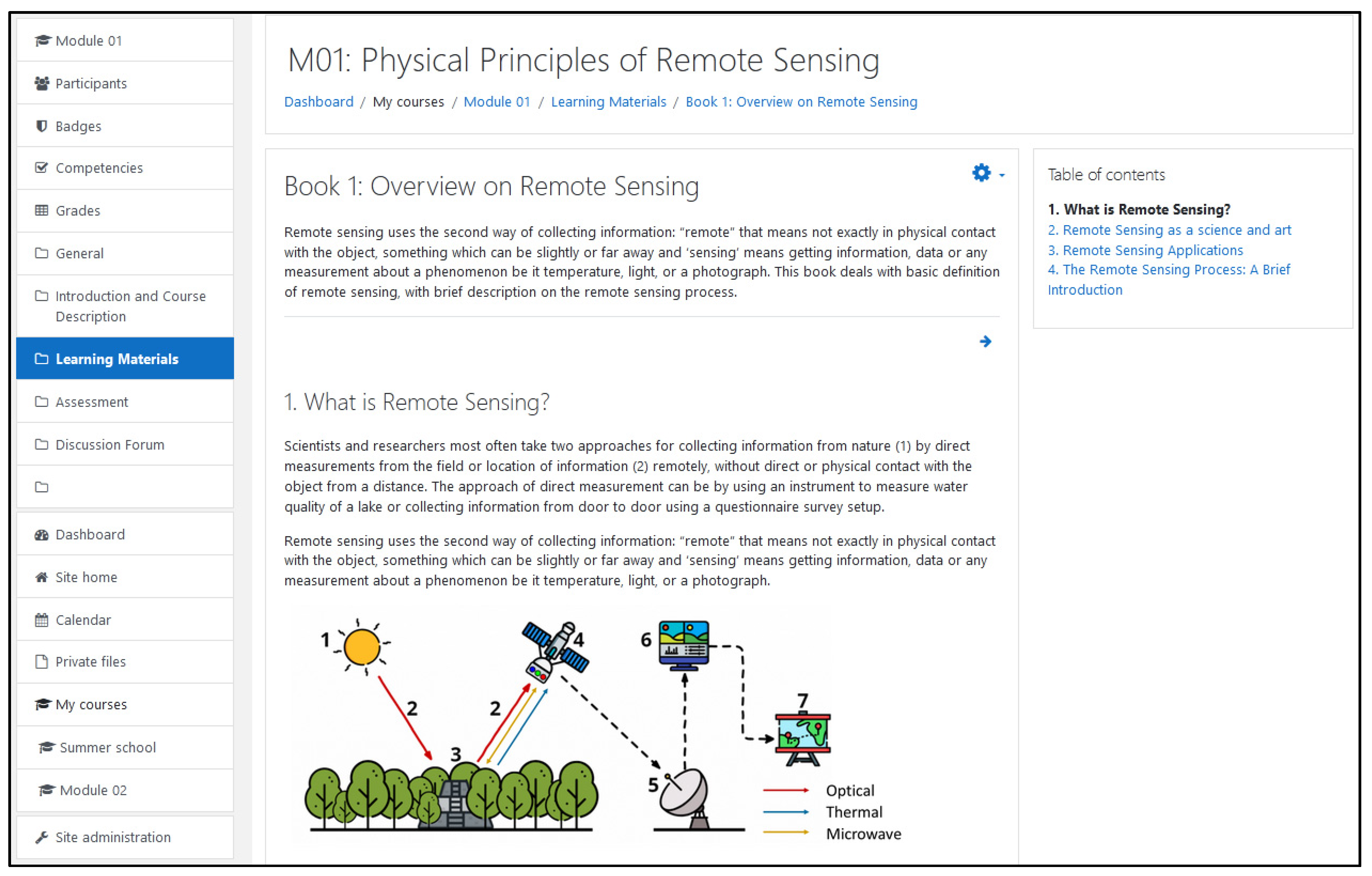
The resource ‘Book’ on the Moodle platform is a multi-page resource with a book-like format, which allows organizing e-learning material in chapters and subchapters (see
Figure 2). Navigation between specific items is very easy. A ‘Book’ is not an interactive e-learning tool, but links to other resources are enabled, e.g., to external web pages, movies, and quizzes [
25]. In IRSEL, the use of books was chosen to develop the generic remote sensing modules (see
Table 1).
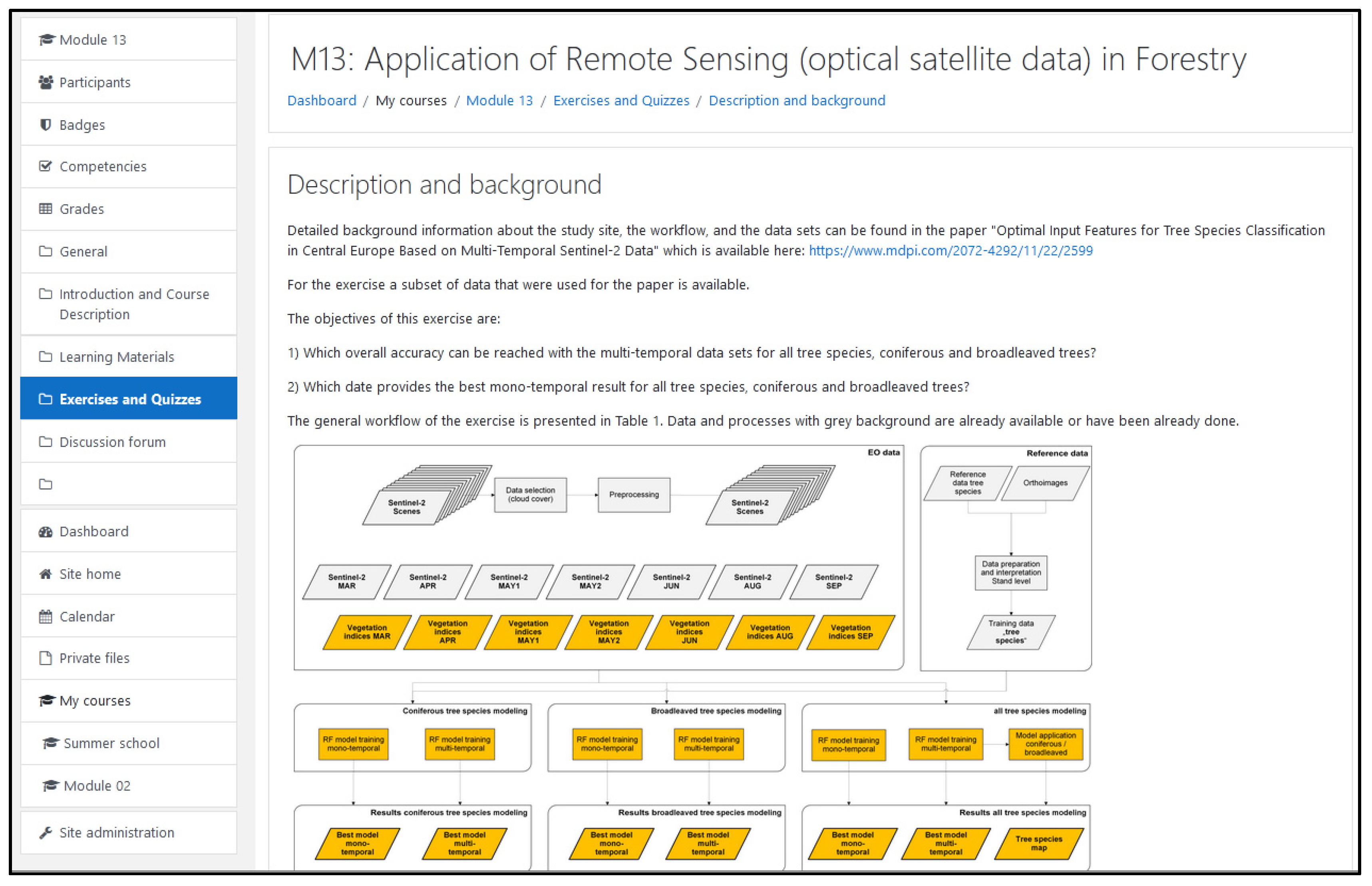
Supplementary materials, exercises, and case studies in the IRSEL modules were mainly implemented with the Moodle resource ‘Page’ and ‘File’. ‘Page’ provides the e-learning content or activity in a text format, but also images, audio, and/or video material, or any other code can be embedded. An example is given in
Figure 3. Other resources can be linked, e.g., external web pages, movies, quizzes, etc. [
25]. The ‘File’ resource enables uploading and accessing all types of files. To open and handle proprietary file formats (e.g., specific GIS or remote sensing file formats), the students need access to the specific software [
25]. In IRSEL, both activities were prioritized to deliver the thematic modules (
Table 2).
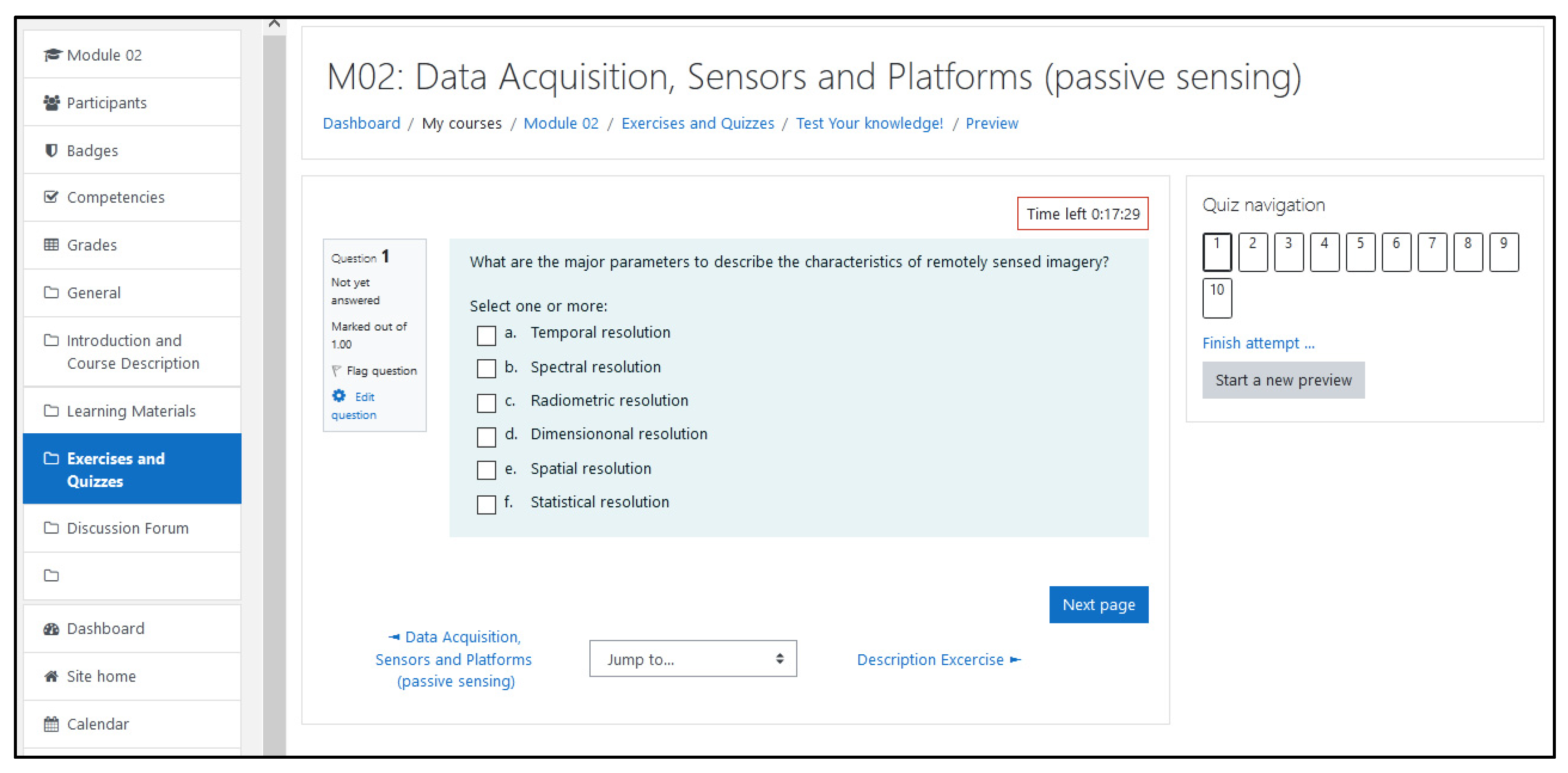
The ‘Quiz’ tool was implemented for self-assessment, usually at the final stage of a module. ‘Quiz’ enables a bundle of question types, e.g., multiple-choice, true-false, matching, short-answer, numerical, drag and drop images, and text [
25].
Figure 4 shows one question of a quiz.
Each module contains a ‘Discussion forum’ to allow asynchronous communication among the students and with the teachers.
For the easy use of the modules, there is always a short course description at the beginning. This includes the objectives, the intended learning outcomes, a concise content, learning and teaching methods, and assessment. The learning material developers were developing their own module specifications. This process required a cross-functional implementation. In the design of the detailed content, a competency matrix was used to help the harmonization of the work.
3.3.3. Challenges
As mentioned before, the Moodle LMS is characterized by high usability and good documentation. Therefore, handling Moodle was not a problem for the project members.
However, the developers faced challenges in the didactical and pedagogical aspects of the modules: e.g., which Moodle activities are suitable for achieving the defined learning outcomes in general and, in particular, which contents should be communicated with which tool.
It was required to provide both generic and thematic modules as homogeneously as possible to make learning easier for the students. Although many project staff members already had an extensive pool of digital documents, considerable effort was required to adapt and improve the existing materials to the agreed objectives and structure.
The students are involved in practical work through case studies. Descriptions and data (geodata) are provided on the e-learning platform. It was important to ensure that on the one hand, the geographic extent of the study area was suitable for the respective application and on the other hand, the size of the corresponding dataset required for the processing was suitable for downloading within a reasonable time—even with a sub-optimal internet connection. This requirement was a challenge, especially for time-series investigations.
3.4. Quality Assurance
3.4.1. Background
Quality assurance and evaluation were important within the IRSEL project; thus, a separate work package was dedicated to them. A quality monitoring system was installed to ensure and enhance both the operational quality of the project and the excellence of the project output.
3.4.2. Implementation
For a coordinated operation, regular presentations of the work packages and the planned learning module contents were included in the workshops and review meetings. For monitoring the quality of the main project outcomes, an External Evaluation Board (EEB) was created. Members of the EEB were selected from the associate partners of the project and other recognized professional institutions. The EEB provided three external evaluation reports.
The project consortium carried out several pilot activities to test the developed learning and teaching materials. Teachers and students assessed the quality of the material at the European and Asian partner institutions using the modules in their regular classes. Students had the opportunity to study the modules and afterwards to evaluate the quality. Asian partners carried out the main piloting of all modules at the same time. After completing the modules, the students answered questions about the quality of the materials offered, comprehensibility, technical feasibility, and benefits. They also got open questions about what they liked or what should be improved and the time they needed to complete the course. The overall feedback was very positive. Students appreciated the up-to-date content, the quality, and the exercises with geospatial data provided within the modules. As the students had a different level of experience in remote sensing and did not complete all modules, thus, a quantitative analysis is a good indicator but not significant from a scientific point of view. Both the external review and the pilot activities provided very helpful feedback for the improvement of the modules.
3.4.3. Challenges
Due to the broad range of the topics, levels, and contents, the development of the modules was not entirely parallel. The workload of modules was not homogeneous, either. Therefore, comparisons between the modules were not always possible, and some modules could not be evaluated the same way as others.
A planned summer school at AIT was rescheduled into an online summer school, due to the restriction for travels in 2020 because of the COVID-19 pandemic. In total, 29 students participated. The teaching methods used were lectures by all eight partner universities followed by self-study using the materials developed in IRSEL. The students had to give regular presentations on their progress. In the end, students were asked whether the English language was an issue in the learning process. Regarding the learning process, 18% of the Thai students and 50% of the Chinese students indicated language as a hindrance. However, they also mentioned that the group discussions, recorded videos, and translating platforms during the summer school helped them improve the learning.
4. Lessons Learned and Recommendations
Developing a comprehensive e-learning platform with project partners from different scientific and cultural backgrounds is a big challenge and requires a detailed organization. Based on the experiences of the IRSEL project, the key challenges will be summarized in this chapter, and recommendations will be given to meet problems occurring during projects with similar characteristic.
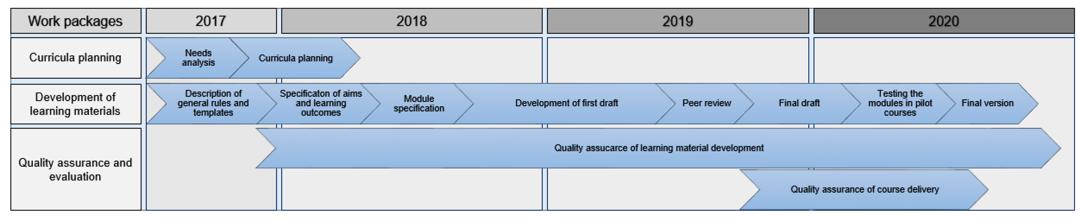
Figure 5 shows a timeline of the major work packages related to the development of the modules.
Language problems belong to the basic difficulties. English was chosen as the common language. For most participants, language was not an issue during the development of the contents. However, the summer school revealed that students in the target countries are not always familiar with English and their effort for elaborating the modules was higher than expected. In the requirement analysis, the stakeholders were asked about the potential language problem, as the learning materials were prepared to target students mainly from Asia. It was found that among 55 universities, 42 (76%) indicated that their students have limits to foreign language, while 11 universities (20%) had no problem with the English language.
Initially, it was intended that all modules should be elaborated in a joint co-operation of European and Asian partners. Finally, active cooperation between the partners was limited due to different scientific backgrounds and the limited available time. Nevertheless, partners contributed with feedback on each other’s work.
Another faced difficulty is strongly related to the inherent problem of many remote sensing solutions: in some case studies, processing techniques and methods are tailored to specific local environmental phenomena, which are not fully transferable to other geographic locations.
Coordinating the different didactical cultures of the project partners was another interesting challenge. This occurred in different structuring of the teaching material as well as the different use of LMS functions. This question popped up in many meetings and led to long discussions. A clear definition of the structure of the learning material needed an elaborated consensus, although the consortium worked hard on it from the very beginning of the project.
During the first stage of the project, the selection of remote sensing, GIS, and image processing software to be used in the modules was discussed, since covering all the software offered on the market would have exceeded the scope of the project. Finally, it was agreed to use open-source software, e.g., QGIS, Snap, and the programming language R. Commercial software was applied only for specific case studies, but even in these cases, a demo version or at least an educational, time-stamped version of the particular commercial software was considered to be available.
Currently, because of the COVID-19 pandemic, almost all academic institutions across the world are enhancing the “Distance Learning” concept by utilizing educational technologies to support students. The developed content can be used by universities in the future to provide distance learning programs for regular students and for life long learning activities.
IRSEL meets the specifications of Erasmus+ CBHE projects to modernize, internationalize, and increase access to higher education. Due to personal and face-to-face contacts, intercultural awareness and understanding were increased. Erasmus+ CBHE programs are essential drivers to build academic networks and to enhance cooperation between different institutions and sectors in the field of remote sensing.
5. Conclusions and Outlook
In contrast to traditional learning materials, such as textbooks, scripts, or simple slides of presentations, an e-learning platform offers a wide range of learning support. Learning material can be used interactively, and the students can determine the pace of the learning process themselves. Furthermore, students can use the platform independently from place and time.
An important component of the developed material is the set of case studies related to the advanced modules, which improve the understanding of the content. Students can learn the practical implementation of the knowledge gained in the theoretical parts. Students and teachers can use the material to develop their own case studies in a different geographic environment. Modules introduced in this article can easily be linked to each other and other websites.
Interaction between teachers and students can be achieved via various communication tools provided by the e-learning platform (bidirectional and multidirectional; synchronous and asynchronous; written or oral). All these communication tools help students ask questions and teachers to give feedback properly.
Further development of the platforms could be a community-based process. First, using the LMS as developed in the IRSEL project and running it at four knowledge centers enables teachers to keep the material updated more easily, as the content can be mirrored from one center to the others. Although not a part of the IRSEL project, continuous update and development of the learning content by future users of the LMS can be an option. This would enable a number of improvements to the platform: frequent updating and adaptation of content, introduction of new aspects, expansion of modules with examples from different geographic regions, and an increase in quality. In this way, the case studies will cover a bundle of applications as well as various problem-solving approaches from different thematic fields. This will contribute to meeting the challenges of sustainable development.
Author Contributions
Conceptualization, T.B., M.I. and R.M.; methodology, T.B., M.I. and R.M.; writing—original draft preparation T.B., M.I., R.M., L.F., I.O., A.v.L., A.S.-M., J.K., M.V.W. and C.M.; writing—review and editing, T.B., M.I., R.M., F.V., L.F., B.M., Z.V., S.N. and C.M.; supervision, T.B.; project administration, B.M. and L.F.; funding acquisition, B.M. and L.F. All authors have read and agreed to the published version of the manuscript.
Funding
The project “Innovation on Remote Sensing Education and Learning (IRSEL)” which is described in the case report was co-funded by the Erasmus+ Programme of the European Union. Ref. No 586037-EPP-1-2017-1-HU-EPPKA2-CBHE-JP.
Conflicts of Interest
The authors declare no conflict of interest.
Appendix A. Generic Modules
M01 Physical principles of remote sensing: This module provides students with physical principles of remote sensing giving a deeper understanding of remote sensing processes. The focus is on theory and laws of the nature of Electromagnetic Radiation (ER) as well as its interactions with the atmosphere and earth surface. Additionally, this module introduces to spectrometry in remote sensing. Spectrometer types, applications, and approaches to conduct laboratory and field experiments are outlined.
M02 Data acquisition, sensors, and platforms (passive sensing): The module gives an overview of different sensors and platforms for the acquisition of passive Earth Observation (EO) data with an emphasis on satellites. EO data, and subsequently the sensors, are characterized by the different types of resolutions (spatial, spectral, temporal, radiometric). The main platforms—such as unmanned aerial vehicles (UAV), airplane, and satellite—are presented. Furthermore, the data acquisition process and the different types of sensors (frame cameras, scanners) are highlighted.
M03 Data acquisition, sensors, and platforms (active sensing): This module aims to introduce basics of active remote sensing technologies. It covers the basics of radar imaging systems. Differences of sensor types and platforms are discussed. The characteristics of scattering and reflection of microwave energy from various types of surface are also discussed in this module. In addition, the concept of the LiDAR (Light Detection and Ranging) is given. Exercises and simple case studies allow students to explore a range of practical techniques.
M04 Airborne photogrammetry remote sensing simulation: The learning outcome of this module is to understand and master the definitions and classifications of aerial photogrammetry and remote sensing as well as the mission, history, and current status of aerial photogrammetry and remote sensing. Students will understand the whole workflow of the photogrammetric process, and after successful complementation of the module, their theoretical basis about aerial photogrammetry will allow them to solve practical problems.
M05 Digital image processing I: This module aims to introduce basic as well as advanced techniques of digital image processing. It covers the fundamental concepts required to understand and apply commonly used and more advanced algorithms for pre-processing of remotely sensed data, image manipulation, characterization, segmentation, and feature extraction.
M06 Digital image processing II—Image classification and interpretation: This module aims to introduce basic as well as advanced techniques of digital image processing. It covers the fundamental concepts required to understand and apply commonly used and more advanced algorithms for classification of remotely sensed data. It focuses on image classification knowledge, techniques, and skills for getting information from imagery and ability to solve complex tasks based on remote sensing. Emphasis is placed on gaining a practical understanding of the principles behind each technique and a consideration of their appropriateness in different applications
M07 Available software applied in remote sensing: This module aims to introduce software tools available for applications in remote sensing. Remote sensing software landscape will be introduced, and methodologies of using this software for real-world problem solving will be explored. Some selected fully-fledged software packages including proprietary, free, and open source software will be used for image processing, analysis, and visualization processes or for information extraction.
M08 Land change detection: This module aims to introduce concepts of land change and basic and advanced techniques for digital change detection of the land surface. It builds on fundamental concepts related to principles of remote sensing and basics of image processing and enhances the knowledge and skills of students into a temporal dimension. Topics are presented with examples and case studies are supported by remotely sensed and ancillary data.
M09 Terrain modeling and analysis: This module introduces concepts of digital elevation models. Basic and advanced techniques for analyzing and visualizing terrain and surface modules are presented. The module is based on the fundamental concepts related to principles of photogrammetry, remote sensing, and image processing, extending knowledge and skills into the third dimension.
M10 Remote sensing and Geographical Information Systems (GIS): This module introduces the basic concept of GIS and applications used with remote sensing data. Understanding these technologies and interaction between them is essential as remote sensing and GIS are proper tools to explore the characteristics of spatial phenomena.
Appendix B. Thematic Modules
M11 Application of remote sensing in agriculture: This module aims to provide the principles, potentials, and challenges of EO technologies in the context of crop type mapping, change detection, and more generally, crop condition monitoring. It combines theoretical and practical sessions. The scope of the practical (computer-based exercises) is to consolidate the theory, to learn and train practical skills, and to apply problem-solving methodologies to real-life examples. The focus lies on the benefits of multi-spectral data to retrieve crop biophysical indicators and the use of multi-temporal data to study the changes and evolution of these indicators over time.
M12 Vegetation mapping and monitoring: This module provides students with knowledge of satellite remote sensing processing techniques and analysis for vegetation mapping and monitoring. Derived products of vegetation index, water stress, etc. are generated to track the length of the growing season, vegetation health, and anomalies.
M13 Application of remote sensing (optical satellite data) in forestry: This module presents different application possibilities of remote sensing in forestry. The focus remains on tree species classification on different levels of detail. Additional contents are biomass/growing stock estimation and change detection applications for forest monitoring. Starting with the presentation of existing and free available data products, the module provides some basics about different (active and passive) remote sensing data and analysis techniques.
M14 Monitoring the environment by using remote sensing: This module aims to introduce remote sensing methods of mapping, monitoring, and modeling of the resources for the management of the environment and for solving environmental problems. It helps learners to understand the methods of analyzing environmental problems using remote sensing tools for identification and applications to support solutions for decision making.
M15 Application of remotes sensing in water management: In this module, the theoretical background of the different water budget components is discussed. For each of the components the role of earth observation is highlighted. To assess the water balance component, data are needed, which can be obtained from the ground and/or from satellite observations and/or already available satellite products. This module explains how to gather and combine data from these two sources, and where applicable, it refers to procedures already included in linked courses.
M16 Oceans/sea and coastal monitoring: The main objective of the module is to give an overview of earth observation solutions related to ocean and coastal monitoring. After a generic overview, which covers all application fields, some aspects are described in detail, including water quality and sea surface monitoring and coastal processes monitoring.
M17 Remote sensing in archaeology: This module aims to provide students with knowledge of airborne and terrestrial remote sensing in archaeology in order to perform archaeological site detection and identification. It covers the fundamental concepts for data pre-processing and analysis of the various airborne and terrestrial remote sensing methods to derive an integrated archaeological mapping and interpretation of detected structure and features.
M18 Application of (optical) remote sensing of urban environment: This module provides the principles, potentials, and challenges of earth observation technologies in the context of land cover mapping, monitoring, and change detection in an urban environment. The scope of the practical (computer-based laboratory exercises) is to consolidate the theory, to learn and train practical skills, and to apply problem-solving methodologies to real-life examples. The focus lies on the added values of multi-spectral data to retrieve vegetation biophysical indicators and the use of multi-temporal data to study the changes and evolution of these indicators over time.
M19 Disaster monitoring: This module aims to introduce the benefit of satellite images for monitoring disaster such as flood, drought, tsunami, hurricanes, earthquakes, and pollution. Data are provided for detecting and analyzing each kind of disaster. Exercises and case studies allow students to explore a range of practical techniques.
M20 Weather and climate monitoring with remote sensing: This module introduces satellite meteorology and climatology as well as principles of data processing and analyses. The focus remains on particular spectral channels applications and the interpretation of processed weather and climate information. The module content will give also an overview of satellite weather and climate data records and databases as well as data integration toward assessing and monitoring climate change.
References
- Rudahl, K.; Goldin, S.E. OpenDragon: Software and a Programmer’s Toolkit for Teaching Remote Sensing and Geoinformatics. Open Geospat. Data Softw. Stand. 2017, 2, 7. [Google Scholar] [CrossRef] [Green Version]
- Rocchini, D.; Petras, V.; Petrasova, A.; Horning, N.; Furtkevicova, L.; Neteler, M.; Leutner, B.; Wegmann, M. Open Data and Open Source for Remote Sensing Training in Ecology. Ecol. Inform. 2017, 40, 57–61. [Google Scholar] [CrossRef]
- Augustijn, P.W.M.; Kooistra, J.F.; Vekerdy, Z. Cross-Fertilization between Three Different Teaching Modes for Geo-Informatics Education. In Proceedings of the Sharing Good Practices: E-Learning in Surveying, Geo-Information Sciences and Land Administration, Enschede, The Netherlands, 11–13 June 2008; pp. 121–132. [Google Scholar]
- Glowalla, U. Erfolgversprechende Einsatzszenarien für Mehrwert stiftende E-Learning Anwendungen. In Proceedings of the 1. GIS-Ausbildungstagung, Potsdam, Germany, 2–3 June 2005; Volume 1. [Google Scholar]
- Mansberger, R.; Bauer, T.; Heine, E. Flop or Top–Experiences with E-Learning in Academic Education. In FIG Workshop on eGovernance, Knowledge Management and E-Learning; Markus, B., Ed.; College of Geoinformatics, University of West Hungary Budapest: Sopron, Hungary, 2006; p. 13. [Google Scholar]
- Márkus, B. E-Learning Experiences. Geogr. Tech. 2011, 14, 45–55. [Google Scholar]
- Devriendt, D.; Goossens, R.; De Wulf, A.; Binard, M. Tools and Techniques for E-Learning. In International Archives of Photogrammetry, Remote Sensing and Spatial Information Sciences; König, G., Lehmann, H., Köhring, R., Eds.; ISPRS: Hannover, Germany, 2003; Volume XXXXVI-6/W30. [Google Scholar]
- Schiewe, J.; Ehlers, M.; Wagner, E. E-Learning-Projekt “Fernstudienmaterialien Geoinformatik (FerGI)”: Konzeption, erste Ergebnisse und Beitrag für die Zukunft. In Proceedings of the 1. GIS-Ausbildungstagung, Potsdam, Germany, 2–3 June 2005; Volume 1. [Google Scholar]
- UNOOSA External Online Training Opportunities. Available online: http://www.un-spider.org/links-and-resources/online-training-opportunities (accessed on 21 August 2020).
- ISPRS ISPRS WG VI/2-Quality Assurance. Available online: https://misc.gis.tu-berlin.de/ISPRS/GUIDE/overview.php?category=Content&search=Start+Search (accessed on 21 August 2020).
- Eckardt, R.; Urbazeaev, M.; Eberle, J.; Pathe, C.; Schmullius, C. E-Learning in the Context of Earth Observation-Best Practices, The EO College and the First MOOC on Radar Remote Sensing; Earth Observation Services GmbH: Jena, Germany, 2018; p. 76. [Google Scholar]
- Pateraki, M.; Baltsavias, E. Eye Learn-An Interactive WEB Based E-Learning Environment in Photogrammetry and Remote Sensing. In Proceedings of the ISPRS Archives, Potsdam, Germany, 3 June 2005; Volume XXXVI-6/W30, pp. 23–27. [Google Scholar]
- König, G. Best Practice in E-Learning: Applications in Photogrammetry, Remote Sensing and GIS. In Proceedings of the ISPRS Archives, Potsdam, Germany, 19 June 2009; Volume XXXVIII-6/W7. [Google Scholar]
- König, G.; Shih, P.T.Y.; Katterfeld, C. E-Learning-Best Practice in Photogrammetry, Remote Sensing and GIS-Status and Challenges. ISPRS Int. Arch. Photogramm. Remote Sens. Spat. Inf. Sci. 2012, 39B6, 91–96. [Google Scholar] [CrossRef] [Green Version]
- Krüger, A.; Brinkhoff, T. Konzeption, Entwicklung und Einsatz von e-Learning-Modulen in der Geoinformatik. Photogramm. Fernerkund. Geoinf. 2006, 2006, 371. [Google Scholar]
- Fisler, J.; Bleisch, S.; Niederhuber, M. Development of Sustainable E-Learning Content with the Open Source ELesson Markup Language ELML; König, G., Lehmann, H., Köhring, R., Eds.; ISPRS Working Group VI/1-VI/2: Potsdam, Germany, 1–3 June 2005; Volume XXXVI-6/W30, p. 2005. [Google Scholar]
- EO4GEO Consortium EO4GEO. Available online: http://www.eo4geo.eu/ (accessed on 4 December 2020).
- Turnbull, D.; Chugh, R.; Luck, J. Learning Management Systems: An Overview. In Encyclopedia of Education and Information Technologies; Tatnall, A., Ed.; Springer: Cham, Switzerland, 2019; pp. 1–7. ISBN 978-3-319-60013-0. [Google Scholar]
- König, G.; Schiewe, J. E-Learning Courses for GIS and Remote Sensing in Germany: Status and Perspectives. Int. Arch. Photogramm. Remote Sens. Spat. Inf. Sci. 2006, XXXVI, 65–70. [Google Scholar]
- European Commission Space Strategy for Europe; European Commission: Brussels, Belgium, 2016; p. 13. Available online: https://ec.europa.eu/transparency/regdoc/rep/1/2016/EN/COM-2016-705-F1-EN-MAIN.PDF (accessed on 2 October 2020).
- European Commission Erasmus Fact Sheet: EU-Asia Academic Cooperation through Erasmus; European Commission: Brussels, Belgium, 2017; p. 2. Available online: https://ec.europa.eu/assets/eac/erasmus-plus/factsheets/regional/erasmusplus-regional-asia2017.pdf (accessed on 2 October 2020).
- Creative Commons Corporation Creative Commons—Attribution 4.0 International—CC BY 4.0. Available online: https://creativecommons.org/licenses/by/4.0/ (accessed on 22 September 2020).
- Moodle Pty Ltd. Moodle-Open-Source Learning Platform. Available online: https://moodle.org/?lang=en (accessed on 2 October 2020).
- IRSEL Consortium Innovation on Remote Sensing Education and Learning. Available online: http://irsel.eu/ (accessed on 4 December 2020).
- Moodle Community MoodleDocs. Available online: https://docs.moodle.org/39/en/Main_page (accessed on 22 September 2020).
| Publisher’s Note: MDPI stays neutral with regard to jurisdictional claims in published maps and institutional affiliations. |
© 2021 by the authors. Licensee MDPI, Basel, Switzerland. This article is an open access article distributed under the terms and conditions of the Creative Commons Attribution (CC BY) license (https://creativecommons.org/licenses/by/4.0/).


 ,
, 


