1. Introduction
The theory and first implementations of geographic information systems (GIS) date back to the 1960s, but the first complete software that could perform a variety of analyses appeared only in the 1980s: the first versions of GRASS and ArcInfo were both released in 1982, followed by Mapinfo (1986) and IDRISI (1987). All of the first GIS software programs had a command line user interface and were not easy to use; the learning curve was steep, and they required previous knowledge of the theories of digital cartography. From the year 2000 onwards, desktop GIS programs with a user-friendly interface became more and more available, and users, even with a limited theoretical background, could easily visualize and handle data. The development of webGIS technology dramatically changed the way in which geographical data are accessed, published and analyzed. Education dedicated to GIS started to appear in some university curricula in the second half of the 1990s, especially in engineering and geography courses. Currently, some life sciences and social sciences faculties also offer GIS courses to their students, but they are often optional.
The most effective GIS education has been carried out via project-oriented teaching (also known as project-based learning (PBL)), an approach that offers integration between theory and practical training [
1]. The advantages of this kind of training have been highlighted by several authors [
2,
3], who argued that PBL leads to deeper understanding and better competences compared to more traditional teaching methods because students focus on attempting to resolve a realistic problem, learning skills that are later transferable to their careers [
4]. Coupling PBL with free and open source software for geospatial (FOSS4G) science is especially beneficial to students, allowing them to study and explore different tools to solve real-world problems or even to develop customized tools that are missing from proprietary software [
5].
FOSS4G provides a cost-effective tool set for interdisciplinary research and education that is especially important in science programs, where the repeatability of an experimental procedure is crucial [
5,
6,
7,
8]. Learning GIS using FOSS4G tools offers several advantages, linked to the licenses used to distribute the programs, that allow the freedom to learn, improve and share the software [
9,
10]. Choosing FOSS4G in education guarantees independence from a single software house, increasing the number of different tools that can be installed in university laboratories and/or on a single PC by students. FOSS4G is designed to guarantee the interoperability of formats, thus allowing the ability to switch from one program to another during an analysis when different capabilities are needed. Users and students therefore become aware of the importance of open standards, which are also a priority at the European level thanks to the Open Source Software Strategy 2014–2017 and INSPIRE Directive (2007/2/EC) [
11].
The use of FOSS4G allows complete control of the workflow because the algorithms used to process the data are accessible and updateable in the source code. The developing community is usually very active, and many people contribute to promptly fix bugs and problems, resulting in a reliable system. The feedback system, typical of an open source community, with forums, mailing lists and help pages, creates an environment of collaboration and experimentation between users and developers. Finally, avoiding the cost of licenses allows even developing countries, small enterprises or research groups to use the state-of-the-art tools provided by FOSS4G. All of these advantages have an effect on research and education at various levels. Students, professionals and public administration employees can apply what they have learned without buying and managing expensive licenses; they can experiment with the source code; and they can become more aware of the importance of open licenses.
University courses focused on FOSS4G are offered at universities and colleges all over the world; but they are still geographically concentrated in Europe, North America and Japan, and only a few of them are continuously updated [
12]. GIS education at the high school level is still very limited. Despite the fact that GIS knowledge is always required both in research and at the professional level and that desktop GIS programs are easier to use, there is still a gap in the theoretical background, which leads to a series of problems. At the professional level, there are often difficulties in understanding and handling the basis of numeric cartography (topology, scale, resolution, etc.); naive errors (especially with respect to coordinate reference systems) are common; and there are still problems with respect to selecting appropriate datasets and tools. For general users, most of the difficulties arise from the limited capability of the interpretation of maps and from unawareness of the limits of map representations, especially precision and scale.
Several organizations that involve geography, GIS or remote sensing put education at the core of their missions, such as the Open Source Geospatial Foundation (OSGeo) “Geo For All: OSGeo’s Education and Curriculum Effort” [
13], the International Society for Photogrammetry and Remote Sensing (ISPRS) [
14] and the Open Geospatial Consortium (OGC) [
15].
Geo for All is the Open Source Geospatial Foundation’s committee for educational outreach, which works in close collaboration with the International Cartographic Association (ICA) [
16], ISPRS, the United Nations-Geospatial Information Section (UN-GIS) [
17] and other partners worldwide with the mission to make geospatial education and opportunities accessible to all. At the time of writing, this network includes 115 laboratories worldwide, including the ecology and the geodesy and geomatics laboratories at the Dipartimento di Ingegneria Civile, Ambientale e Meccanica (DICAM), University of Trento, and the geomatics laboratory at the Dipartimento di Ingegneria Civile, Chimica e Ambientale (DICCA), University of Genova. From 2010, the DICCA has worked closely with its spin-off Gter srl Innovazione in Geomatica, Gnss e Gis (Gter), which conducts metric and thematic surveys, as well as GIS analysis and training, with a particular aim towards public administrations and technicians.
Most of the literature on PBL and GIS education using open source software focuses on the skills acquired by students, while this work also takes into account the challenges (in terms of effort related to material preparation and updating according to student feedback and to the continuous software upgrades) faced by educators who choose to use FOSS4G. In this work, we aim to describe the advantages and disadvantages of using FOSS4G in education based on 20 years of teaching experience, during which we developed and implemented tools for teaching diverse audiences, from undergraduates to professionals all over the world.
The paper is organized as follows:
Section 2 describes the educational materials that have been developed.
Section 3 details the courses implemented and their peculiarities.
Section 4 illustrates the feedback from students and trainees, and
Section 5 reports the lessons learned over 20 years by educators in the GIS field. Finally,
Section 6 draws conclusions regarding the experience so far and outlines the future work planned by the authors.
2. Tools for Education
Free and open source software (FOSS) solutions cover the whole range of spatial data applications, from simple map viewing and querying desktop applications to systems providing OGC services. This richness allows the deployment of a FOSS approach for any combination of training level and scope. However, educational materials are quite variable, as the availability and update status are different for different software systems and even for different software versions of the same system.
The features of educational materials must match users’ needs: while new users require step-by-step guidance, with even the smallest difference between the guidelines and the software or dataset in use possibly causing trouble, advanced users, who are usually able to reconcile small differences in software or map appearance or layout, demand a clean and rigorous workflow. This means that some features of educational materials have different levels of importance, depending on the intended use: for introductory courses, the correspondence between the materials and software and the dataset is paramount, while for advanced courses, sparser educational materials can suffice. In general, introductory guides are available for the most popular FOSS GIS suites, but they are tied to specific software versions, while educational materials on specific topics are less abundant and often outdated.
The educational materials developed at the DICAM, DICCA and Gter can be divided into two classes:
The materials include the following:
slides for introductory courses on numerical cartography and GIS [
18,
19];
slides on particular topics, developed for courses on specific subjects [
20];
hypertextual tutorials for some software programs (GRASS and QGIS), developed at the DICAM [
20];
in the Italian and/or English language.
In the case of courses organized by the DICAM, the main software systems are as follows:
desktop GIS used for spatial data management and analysis—GRASS GIS [
21] and Quantum GIS (QGIS) [
22];
spatial database management systems (DBMS)—PostgreSQL [
23] and PostGIS [
24];
OGC (open geospatial consortium) [
15] service providers—Map Server [
25] and Geoserver [
26] (they offer several OGC standards; currently, only web map service (WMS) and web feature service (WFS) services are used);
statistics software and its spatial extension—R [
27] (especially with the spgrass6 package).
At the DICCA and Gter, the courses are mainly focused on GRASS, QGIS and the QGIS server [
28], PostgreSQL/PostGIS and Geoserver [
29,
30]. Other software systems dealing with spatial data, such as gvSIG, OpenJump and OSSIM, are occasionally used to carry out specific tasks, but no specific educational materials have been developed.
Map Server and Geoserver (WMS and WFS), along with PostgreSQL and PostGIS, play two different roles: they are used as educational tools for OGC services, and at the same time, they have been deployed in two campus-wide services, providing digital maps for educational and research purposes. These two services allow students to experiment with their setup and configuration while using their services. All of these software systems share the common advantage of having a free software or open source license; therefore, the availability of their source code is always assured: this constitutes the definitive documentation for the systems, allowing teachers and students to study their inner workings.
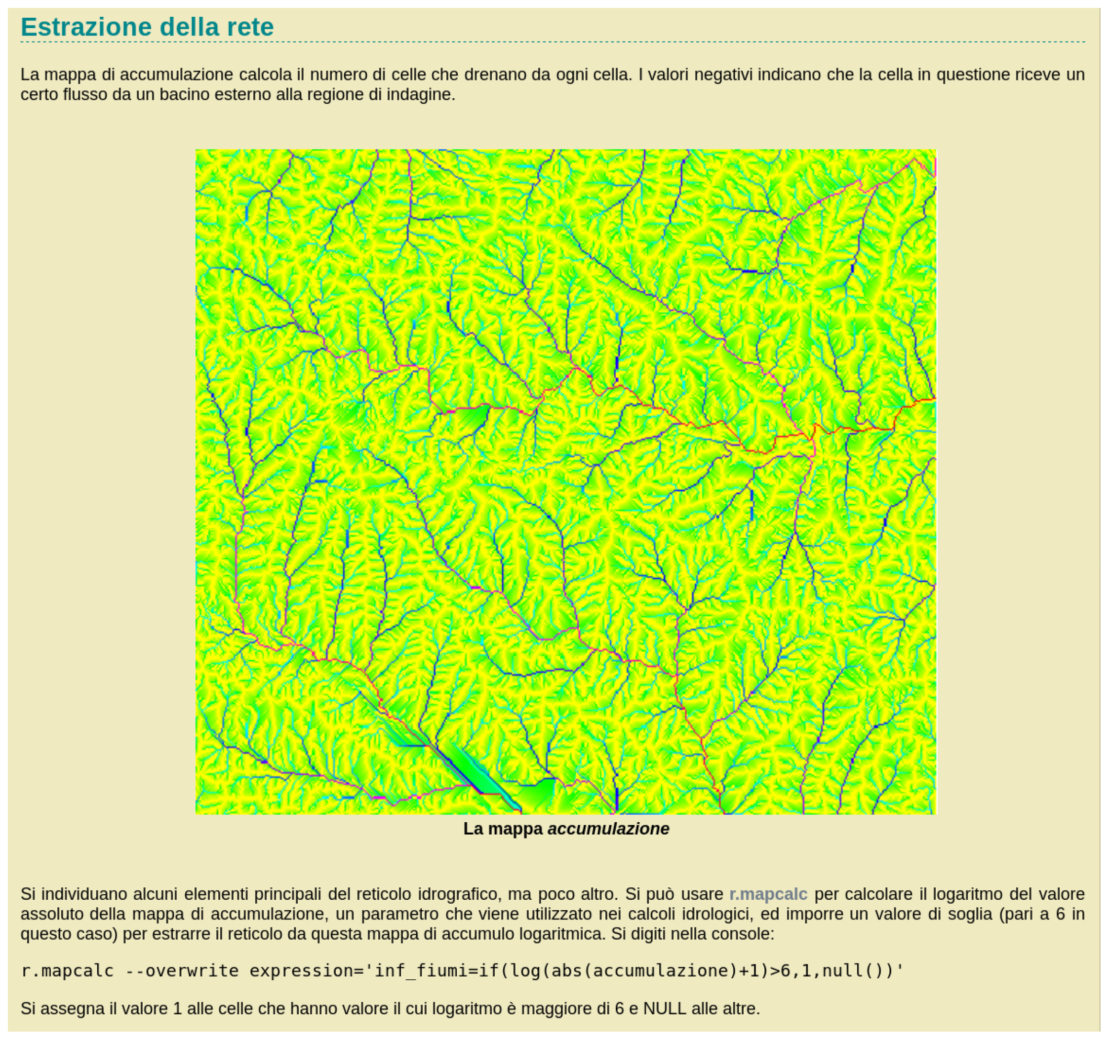
The main educational tool in the GIS field, developed at the DICAM, is a hypertext GRASS tutorial [
20,
31,
32,
33]. This tool has been in development since the year 2000, evolving with the GRASS GIS development and the experience gained using the previous versions. The continuous cycles between the updating of the tutorial and its use by different types of students have led to a constant improvement of its effectiveness. The tutorial starts with the basic notions regarding the GRASS interface and conventions to cater to beginners and progressively moves towards complex tasks and specific applications. Part of the exercise related to watershed analysis and basins extraction is shown in
Figure 1.
The hypertextual format allows the implementation of different paths during the tutorial, from a linear path, starting from the basic GRASS usage and progressing towards more complex applications, to tailored routes, where connections between parts are exploited according to the reader’s needs. Furthermore, external sources are linked to provide additional information.
The tutorial has been created for two different classes of users: (1) the self-taught person who is interested in learning how to use GRASS GIS and accesses the tutorial via the Internet and (2) the student who learns how to use GRASS during a workshop or a course, where expert assistance is available. While in the first case, the advantage is evident, in the second case, the benefit with respect to a tutorial that uses a procedure explained in real time is that students with different learning speeds, for example, due to different backgrounds or skill levels, are able to learn at their natural pace without interruptions or missing passages of the procedures. The tutorial is available in the Italian and English languages, but the two versions are not always aligned because updating the tutorial requires a considerable amount of work by a GRASS expert. Therefore, this is done when the tutorial use in a course is foreseen.
While the tutorial is intensively used for GIS and GRASS courses at the DICAM, other institutions, such as universities and training agencies, and freelance GIS instructors are known to use it routinely. The tutorial is freely available on the Internet with a fairly permissive Creative Commons license, CC BY-NC-SA 2.5, allowing the creation of derivative works as long as credit is given to the original authors and it is not used for commercial purposes. The tutorial has been re-licensed under different licenses to specific organizations to allow commercial use.
3. Recipients and Implementation
The FOSS4G software has been used to teach classes at many levels for a large number of learners with extremely diverse backgrounds. The FOSS4G software has been used in different courses organized both in Italy and abroad:
bachelor’s degree and master’s degree courses at a university (in Italian);
doctoral PhD courses (in English);
courses offered to professionals and technicians working in private and public administrations (in Italian and English), including introductory generic GIS, cartography and GPS positioning courses;
courses on a specific software (particularly GRASS, QGIS, PostgreSQL and PostGIS);
topics in ecology (animals and vegetation modeling);
one-day workshops for beginners or advanced users (in Italian and English);
international summer school courses (in English);
courses for secondary school teachers (in Italian);
online courses (in Italian).
Dissemination seminars on cartography and its uses have been organized at primary schools, and educational workshops have been made available to kids and teenagers. In all of these courses, FOSS4G software is used as a tool to teach GIS principles or spatial modeling, except for the courses offered to professionals and technicians and one-day workshops, where students already using GISs are interested in trying FOSS4G systems.
3.1. Academic Courses
In 1996, the DICAM began to use FOSS instead of proprietary software in its official courses for engineering faculty students. The first attempts were carried out in a bachelor’s degree project thesis, and the success and positive responses obtained from the students were so inspiring that this approach has been continued. More than 700 theses and exam projects have been developed since then.
In 1998, the DICAM designed and taught the first introductory courses aimed at providing basic GIS concepts to university students in their first, second or third year. FOSS4G was then used as a tool in land planning courses in their fourth or fifth year of education. The main courses included “Ecological and sustainable planning of forest landscape” (1998–2009), “GIS and remote sensing” (2004–2005) “GIS systems and remote sensing in agriculture” (2008), “Radio positioning and GIS” (2009–2010), “Topography and urban and environmental survey” (2010–2013), “Didactic of topography” (2015),“Laboratory of didactic technologies” (2015), “Numerical cartography and GIS” (2004 to present) and “Applied ecology” (2010 to the present). A rough estimate of the total number of students that attended the courses is 1700. The application of spatial data techniques to diverse scientific fields and topics has proven to be a hotbed for interdisciplinary applications; see, e.g., [
34,
35,
36,
37,
38,
39]. Because of the success of these courses, the DICAM introduced the same approach in doctoral courses: “Environmental data management and analysis with GIS” (2006 to the present) and “Field sampling and spatial ecological modelling” (2017). A total of approximately 140 students attended these courses.
The experience at the University of Genoa is more recent. Since 2004, the “Numerical cartography and GIS” course has been offered to students of master’s degree programs in different fields, such as civil and environmental engineering, building engineering/architecture, security engineering, transport and territorial systems, geological sciences, sciences of natural systems, computer science and cultural enhancement of land and landscape (inter-university degree with Milan University), and to students seeking a bachelor’s degree in human sciences related to the environment, land and landscape.
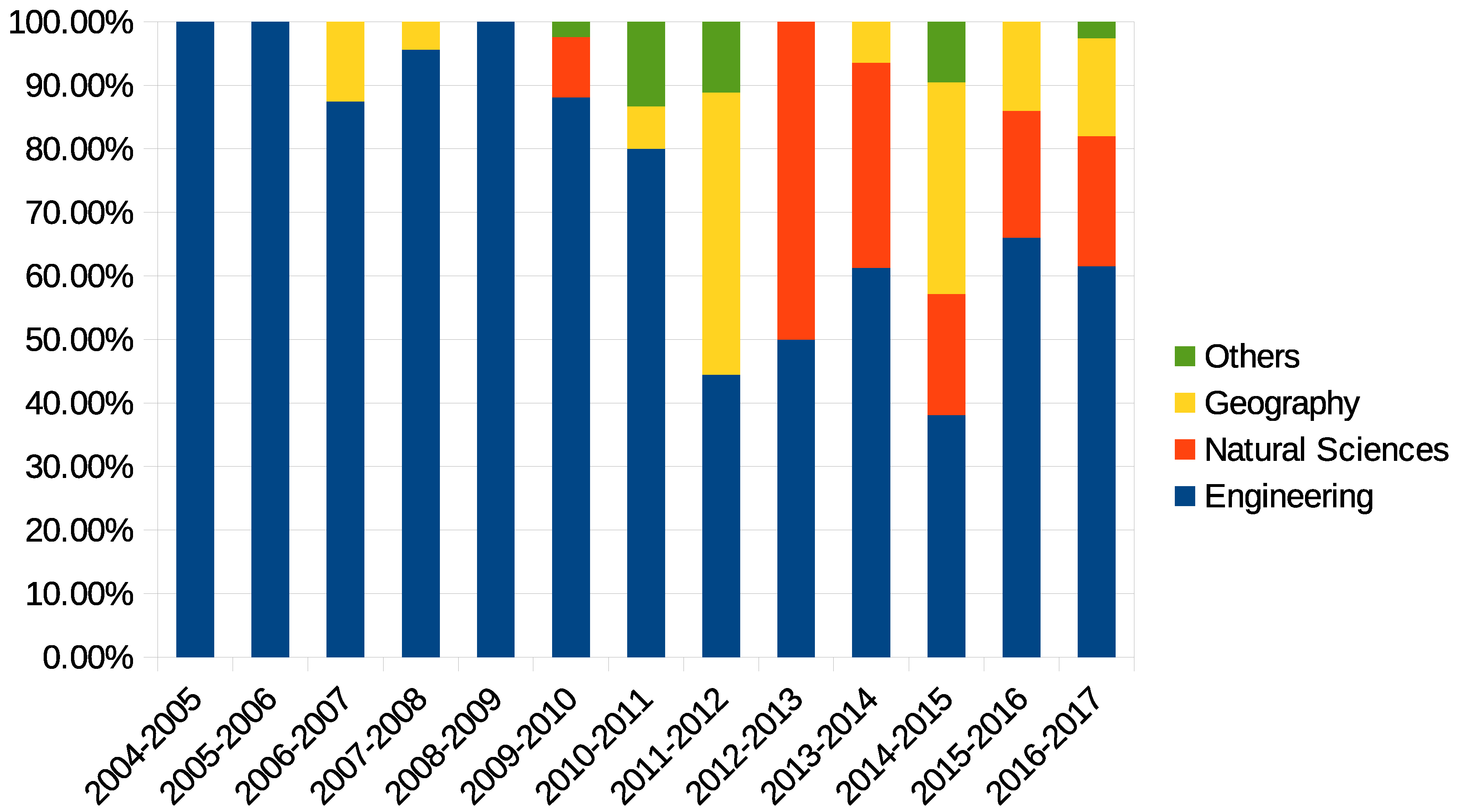
Figure 2 shows the increasing interest of science and geography students regarding GIS tools, due to the increasingly widespread availability of open geographic data.
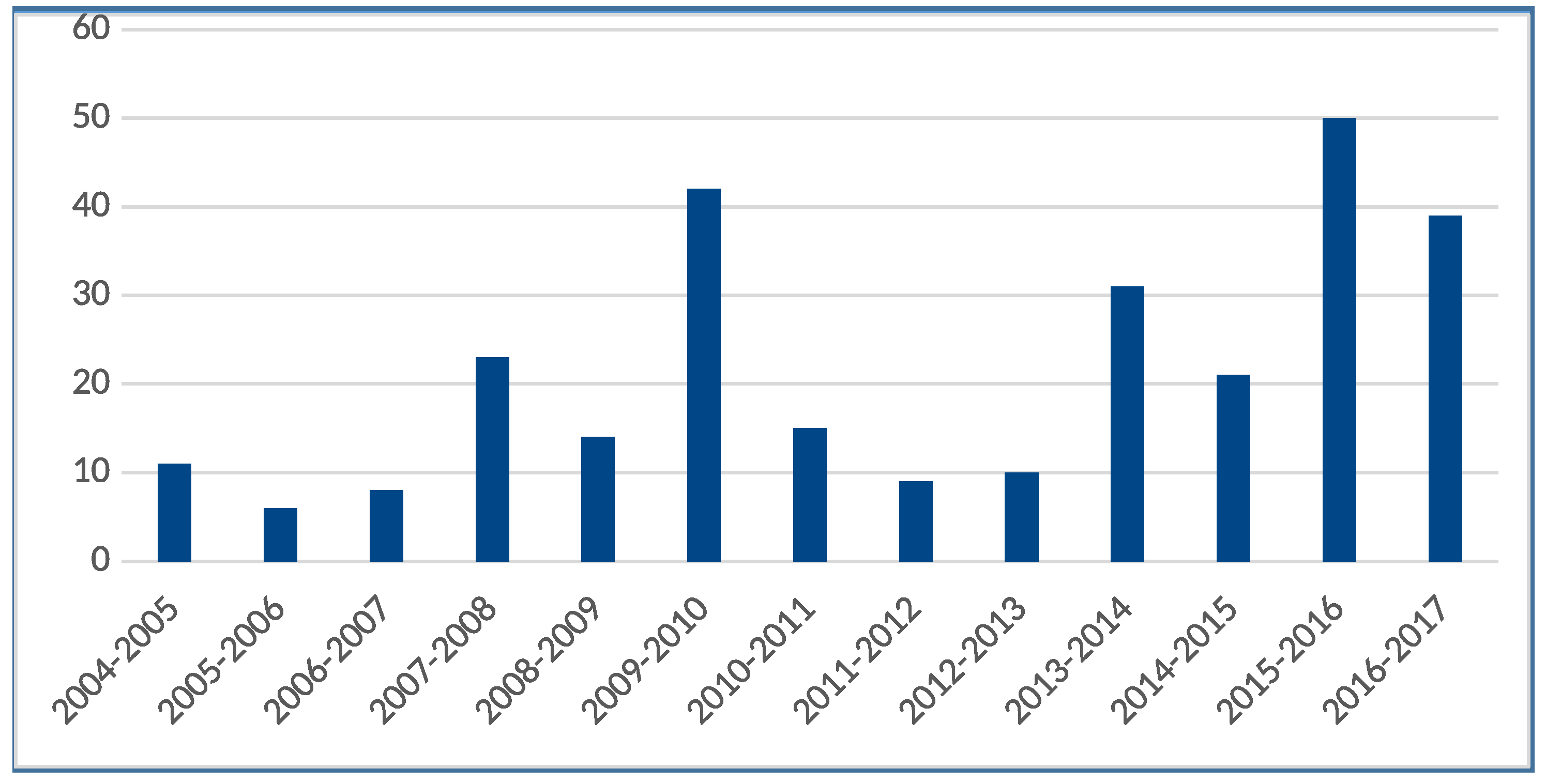
A rough estimate of the number of students that have attended this course over the last ten years is 270, with classes of less than 10 students during the first few years and of approximately 40 students currently (
Figure 3).
The course aims to provide the necessary tools for the management and analysis of different sources of spatial data (cartography, satellite and aerial images, thematic maps, digital terrain models, GNSS and LIDAR surveys, etc.), addressing different applications for planning, managing and monitoring the territory, the environment and the infrastructures. The lessons are structured such that classroom lectures are alternated with practical exercises covering the different fields of numerical cartography and GIS: reference/coordinates systems and projections, raster and vector data models and processing, database management, image classification, webGIS and geo-services and the management of LIDAR surveys, satellite images and GNSS data.
The educational materials include slides for the theoretical lectures and for the practical exercises, which also exploit the DICAM hypertextual tutorial. This tutorial turns out to be very useful at the beginning of the course, when students need prepackaged data (i.e., the North Carolina sample dataset [
40]) to learn how to display and query maps. Then, students learn to import and analyze regional open data by following detailed steps described in the slides developed for the course. At the end of the course, it is requested to develop an exam project on a topic proposed by the professor or the students themselves to show the acquired skills in approaching and solving a problem using geospatial data analysis, paying particular attention to the methods and the final requested/desired results and focusing on the difficulties encountered and the strategies used to solve them. Thanks to the different backgrounds of the students, many different fields have been considered, typically from a multidisciplinary point of view:
susceptibility and risk maps in the case of natural disasters (landslide, flooding, tsunami, earthquake and fire), the impact on populations and buildings and risk mitigation;
network analysis for the evaluation of accessibility, logistics and emergency or natural disaster scenarios for the identification of safe places;
image classification for land cover and land use maps and territory evolution, land and water representation (DTM generation above/below the sea, groundwater level, hydrographic network, basin analysis) and the identification of places for animal reproduction (fish farming);
conservation and promotion of cultural heritage, tourism and georeferencing of historical cartography;
wind and solar energy production, cost assessment and payback period.
The projects developed during the courses showed that the GIS software can be a powerful instrument in many scientific applications, leading to fruitful results even if employed by inexperienced users. Furthermore, the DICCA developed GIS courses introducing students to the inspection and analysis of geographic data, which have been offered to students of the second-level master’s degree in marine geomatics since 2011, to PhD students since 2014 and to students of the Higher Technical Institutes (Istituto Tecnico Superiore-ITS) “expert in ports, coastal, river and lake constructions” given by Gter since 2013.
3.2. Courses for Professionals
The first six courses for professionals and the wider public organized in 1998–2000 by the DICAM were generic GIS introductory courses in which open source software was used to introduce basic concepts and to make users familiar with georeferenced data processing. These courses were organized with the awareness that the vast majority of GIS users in 1998 were beginners; thus, the organizers looked for reassuring, user-friendly graphical interfaces, which were not commonly available in FOSS4G at the time. FOSS4G was more often considered as a research tool; therefore, its user interfaces were crude, and a background knowledge of GIS basics was required to use it. Contrary to expectations, the FOSS4G approach was very much appreciated and was considered to be extremely didactic by our learners.
In 2003, the first course, i.e., “GRASS and Open Source GIS, theory and applications”, was designed and offered. The theoretical-practical course was immediately a huge success and has been taught each year since. In the latest versions, the part dedicated to QGIS has been expanded. The structure of the course is based on an alternation of theory and practice and on a well-structured tutorial that was tested by users in the courses and has been updated and improved throughout the years since the first version was developed in 2000. More than 35 courses (with a total of more than 1000 participants) have been made available to professionals, technicians and the general public since 1998. Some were organized based on our own initiative, while others were organized at the request of specific organizations or administrations, such as the Province of Trento, civil protection, fire department, mountain rescue, professional bodies or associations and private firms. A partial list of the courses organized by the DICAM is available on the web [
20], with detailed information on each course. The courses are usually held in Trento, with some held in Rome, Milan and Aosta. As a cooperation project, a training course in GIS with elements of GPS was organized and taught in May 2009 in Byumba, Rwanda [
41].
The DICCA team organized courses requested by the Province of Savona in 2008 and 2009. Then, since 2013, at least twice a year, the newly-created Gter organizes theoretical/practical courses of 16–40 h each, which have been offered to either any participant or dedicated to the staff of municipalities, provinces, fire departments, regions and regional agencies for environmental protection in Northern Italy.
3.3. One-Day Workshops
The DICAM has also organized and offered a large number of one-day workshops at international events, including GRASS GIS Beginner’s and GRASS GIS and RDBMS, held at the FOSS4G conference in Lausanne (Switzerland) in September 2006 and in Victoria (Canada) in September 2007, and Practical Introduction to GRASS and related software for beginners, held in Cape Town (South Africa) during FOSS4G 2008, Sydney (Australia), during FOSS4G 2009 [
42], and Barcelona (Spain) during FOSS4G 2010.
Other similar workshops were organized (in Italian) by the DICAM and Gter for national GRASS and GFOSS conferences. A total of approximately 750 learners have attended these workshops.
3.4. Summer School
Since 2011, the DICAM organized five editions of the international summer school course “Tropical rainforest biodiversity: field and GIS tools for assessing, monitoring and mapping” at Udzungwa Mountains National Park, Tanzania, in collaboration with the Museo delle Scienze di Trento (MUSE), Tanzania National Parks (TANAPA), Danish Museum of Natural History, University of Copenhagen and the Wildlife Conservation Society [
43,
44,
45,
46,
47]. The summer school is open to bachelor’s, master’s and PhD students from all over the world and combines field experiences with GIS data manipulation. Moreover, a special course for the forest park ecologists of TANAPA (Biodiversity monitoring techniques and standardization across TANAPA forest parks: training course for forest Park Ecologists) was held in August 2013. A total of approximately 110 learners attended all of the Tanzanian courses.
3.5. Teachers of Secondary School
In the period of 2003–2009 at the School of Teacher Education, University of Trento (Scuola di Specializzazione all’Insegnamento Secondario-SSIS), in Rovereto, Italy, teachers were encouraged to try FOSS4G for simple tasks, such as displaying data and querying information, and to take a cue from this to design their class lessons. A total of approximately 200 learners attended the lessons.
3.6. Online Courses
Since 2015, Gter has also offered an online course on GRASS GIS on the Italian platform Geocorsi.it [
48] to professionals, offering professional upgrade credits to engineers, geologists, etc. Geocorsi.it is based on the Moodle open source software, which is used to develop e-learning platforms. Students are provided with a small LaTeX manual on GRASS and some practical exercises; the manual is divided into four chapters: GIS and coordinate reference systems, introduction to GRASS GIS (history, GRASS DB, etc.), basic use of GRASS GIS and advanced features (add-ons, scripting, etc.). Additionally, some self-assessment tests and a forum space for asking questions of the two teachers are available. Since 2015, more than 40 people have attended the online course.
4. Assessment
Most of the courses described in
Section 3 have been evaluated by the attendees. Academic courses are subject to mandatory evaluation by students, while other courses are assessed using anonymous questionnaires after classes have ended.
Students’ evaluations of the academic courses indicate a general appreciation of the available educational material, but only a small percentage of students were able to recognize the value added through the use of FOSS and open licenses for data and educational materials beyond the contingent practical advantages of freely copying documents and data or installing software. Fortunately, the awareness of the importance of open licenses in technical fields increases with the education level. Regarding the courses for professionals organized by the DICAM, the use of custom questionnaires provides more insight into the assessment of attendees. These courses are offered to a heterogeneous audience, including managers and technicians of public institutions, university staff and students, research institution members and freelancers and technicians of private technical offices and companies. A dedicated web page is created for every course, providing a general description of the course’s aims, the teachers’ profiles and the suggested minimal background for the course candidates. A detailed schedule of the topics covered in the course is always published in advance.
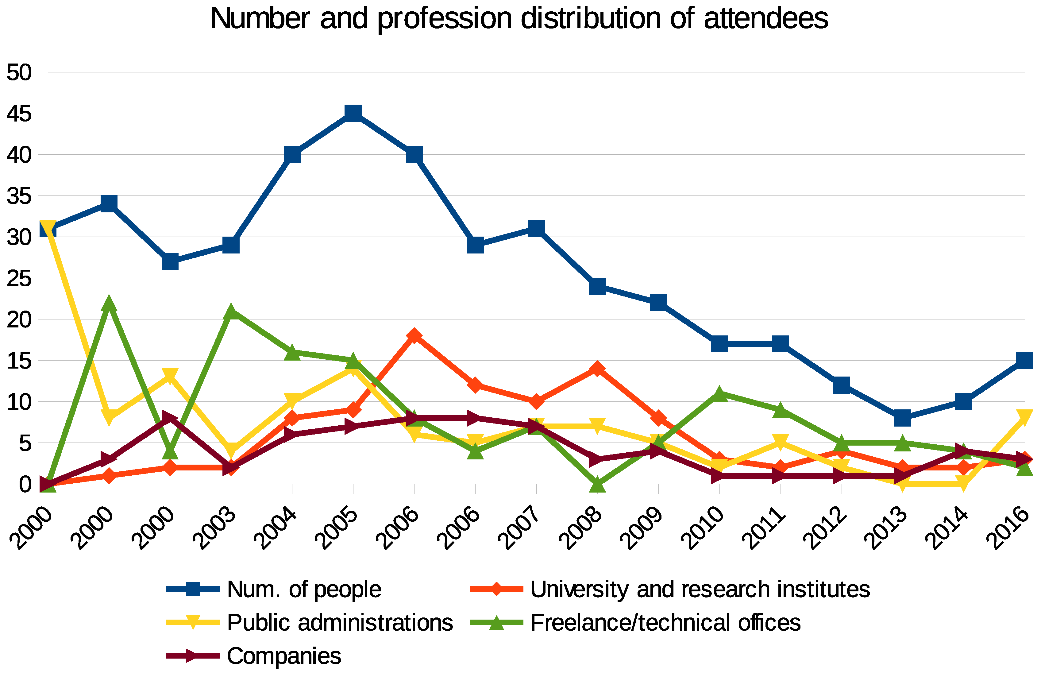
In general, the educational background and GIS skills of the people attending the courses are quite diverse and of different levels. A breakdown of the different classes of participants of the courses designed for professionals based on their occupation (university and research institutes, public administrations, freelance/technical offices and companies) is given in
Table 1 and
Figure 4.
The number of attendees has declined over the last ten years. The main reasons are as follows: the local pool of potential attendees is small; therefore, most of the interested users have already attended a course. Professional associations have started to organize similar courses and have diminished resources devoted to personnel education for public administrations. Moreover, students that have graduated in the last 10 years have already received specific training in GIS. The number of attendees from universities and research institutes peaked between 2004 and 2008. From 2009, freelancers and technicians of private technical offices and companies have composed the most numerous group, with the exception of 2016, when the course format was changed. The quality of each course is assessed at the end of every course via a short questionnaire proposed to the attendees. The aim of the survey is to collect feedback from learners regarding their experiences during the course, providing information useful for the enhancement of successive courses. Four questions are presented to each trainee for evaluation:
the level of the teaching quality;
how much the course matched the learner’s expectations;
how much the course corresponded to the learner’s most common GIS professional tasks;
how well the course’s topics were balanced.
Every answer is expressed using an integer number, ranging from one (for low evaluation/satisfaction) to five (for high evaluation/satisfaction).
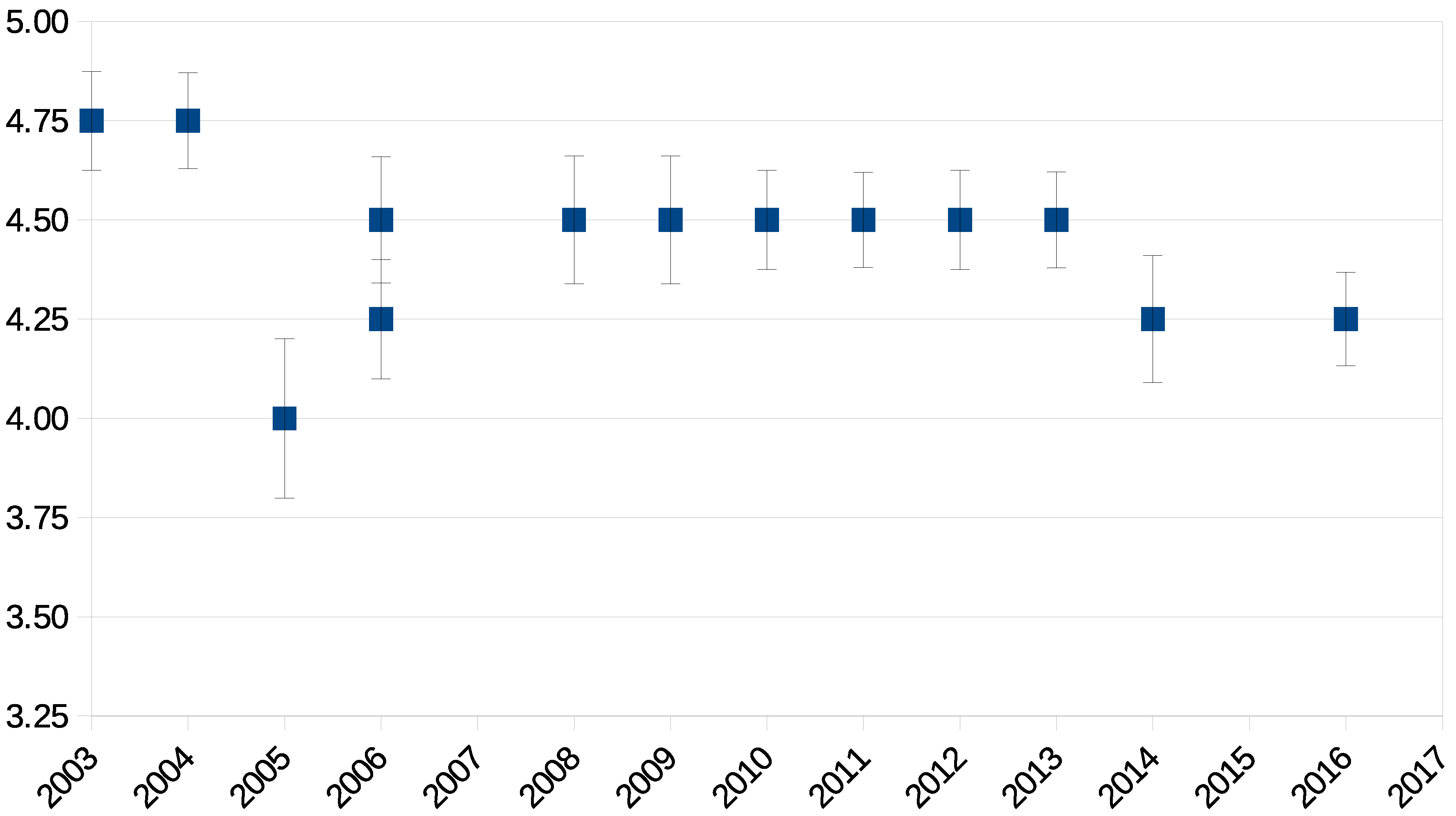
Table 2 shows the average scores, based on the results for several years, for the four questions presented to attendees.
Despite the physiological fluctuations, the high average evaluation scores in
Table 2 clearly show the appreciation of the attendees. The teaching quality scores and their standard deviation for several years are reported in
Figure 5. A weak correlation seems to exist between the score standard deviations and the number of attendees. A further analysis would require a much larger course set and a much larger number of attendees per course to be of any significance.
The survey form includes some additional space to allow learners to offer open comments, suggestions and concerns regarding the course. The two most common comments are as follows:
Another frequent suggestion is to organize the lectures according to specific topics, as well as to offer practical exercises related to the same subjects. Other comments are related to specific interests and propose the study of particular applications or a comparison between FOSS GIS and proprietary suites. Often, suggestions are contradictory, e.g., organize longer/shorter courses and present more/less GIS theory. The first two suggestions led to the organization in 2016 of a two-day introductory GIS course that alternated between lectures and hands-on exercises related to the same topic.
5. Lessons Learned
While the current approach and the educational tools that have been employed thus far have provided satisfactory results, some issues must be addressed.
The development of educational materials requires a large time investment by a skilled person who is familiar with the principles and procedures of spatial data management and analysis and, at the same time, has experience in teaching these topics. The creation of new materials requires more work, but has the advantage of being a one-time effort. Conversely, the maintenance of materials, the need for which arises when a new version of the software becomes available or a new dataset is used, usually requires less work, but can be more tiresome than the original development because of the amount of material that must be brought up to date and because it is usually a less creative and appealing task. The result is that a large amount of the educational material related to GIS, and particularly to FOSS GIS, has been developed for old versions of various systems. This can be a problem for beginners, who are usually not aware of the differences between software versions.
Another critical issue is the lack of spontaneous feedback from users, especially when, as in our case, almost all of the materials are freely available on the Internet and used by hundreds of GIS specialists, scientists and students every year. For example, the feedback for the GRASS tutorial usually consists of a couple of email messages per year (while when the web server is down for maintenance, we usually receive phone calls inquiring about the tutorial availability within the hour). In this respect, the creation of a healthy and open community of teachers and students using the same educational materials is crucial, and the development and maintenance of the materials depends on this community reaching a critical mass.
The FOSS4G software offers a large number of systems, ranging from software with extremely user-friendly interfaces to software to be used with the command line and no graphical interface. Initially, beginners have a relative preference for a user-friendly interface, but once they understand that other, more complicated options, e.g., scripting, are very fruitful, they easily change their attitude and tend to consider the command line interface as an opportunity. Finally, the license chosen can be crucial, especially when considering that not all users will comply with the license for materials available on the Internet. In particular, allowing commercial use of the materials can encourage parasitic behaviors if the organization using the software does not provide feedback or additional material for further development. In our case, the “non-commercial” clause has been used because, on a few occasions, some courses have been cloned, down to the leaflet text, by commercial organizations. The materials are re-licensed for commercial use on demand. To make the materials more valuable, more recent materials have had the “non-commercial” clause removed. The use of FOSS4G in GIS education provides several advantages, but at the same time introduces challenges. Both aspects depend on the aim of the course, e.g., an introductory GIS course vs. courses on a specific software, and on the level, e.g., undergraduate courses require a different approach compared to PhD courses.
The main benefit for teachers is the choice of a wide range of software systems that cover the whole range of spatial applications with different approaches. The availability of the source code, which provides the ultimate documentation for the system, can be used to understand how GIS functions are implemented and to describe them to students. Additionally, it is possible to customize the software to provide ad hoc interfaces or to add a specific algorithm. The downside is the need to manage different software programs that cover the different aspects of spatial data management, while in the case of proprietary software, a comprehensive package is usually provided. For students, the advantages depend on their educational level and on the purpose of the course. Undergraduate students usually do not fully grasp the implications of open source and free software licensing, but appreciate the possibility to install the software on their device. Graduate and PhD students value the transparency and knowledge provided by full access to the code. During the development of their theses, students fully appreciate the advantages of source code availability and the possibility of interacting with a community of developers and users. Some of the software systems have a steeper learning curve, but instead of being a hindrance, this can be exploited to force students to fully understand the procedure they are trying to deploy. A typical example in this sense is the need to select a datum in GRASS GIS when starting a new project (creating a new location in GRASS jargon): the user must know the reference system and cartographic projection of the maps in use. Managers of the computer lab appreciate the lack of the need for license management, which simplifies lab setup and maintenance. The reduction of software license costs is not usually a factor, since universities usually receive steep discounts for bulk licenses, but the simplification of software management can be significant both from the administrative and the technical point of view.
From an educational point of view, the training strengths are not only the skills acquired for approaching and solving problems using geospatial data analysis, but also the awareness of the method and the analysis of the final results, with particular attention paid to their accuracy/resolution, with respect to the input data.
6. Conclusions
Education dedicated to GIS science and, in general, to the theory and systems used for spatial data management and analysis is currently essential for a wide range of disciplines and application fields. Experience is fundamental for the development of courses and educational materials, especially taking into account the diverse recipients, ranging from professionals keen on specific applications to university students interested in theory and principles. The free and open source software (FOSS) approach provides several advantages, and the availability of reliable and accessible FOSS systems for the management and analysis of spatial data fosters the demand for specific training.
At the academic level, free and open source software for geospatial (FOSS4G) science should be encouraged more and more for ethical implications, to support the user community and especially to help beginners, as well as to not link students to a proprietary technology. Private and public technicians should prefer training with free and open source GIS software primarily to comply with regulations on software reuse (the Italian Digital Administration Code (Codice dell’amministrazione digitale [
49]) compels public administrations to make comparative assessments and recommends free solutions instead of proprietary software if their quality is comparable) and for the continuous improvement of the software.
Even users of proprietary software benefit from the possibility of free access to other approaches provided by FOSS4G, stimulating them to deploy innovative methods and techniques while retaining their usual tools. The same holds for educational materials, where documents related to FOSS4G are often available, with licenses allowing their modification and adaptation to proprietary systems. The course evaluations reported in
Section 4 attest to the overall merit of the FOSS4G approach with respect to geospatial education, even if its benefits are often not perceived by students.
The current work concerns the maintenance of the existing educational materials, while future efforts will focus on the expansion of the documentation and tutorials on environmental modeling using GIS, with particular consideration of sensors management via OGC’s sensor observation services (SOS) and sensor web enablement (SWE) standards and implementations.

 ,
, 


