
Groundwater Exploration for Rural Water Supply in an Arid Region of Southern Argentina

Abstract
:1. Introduction
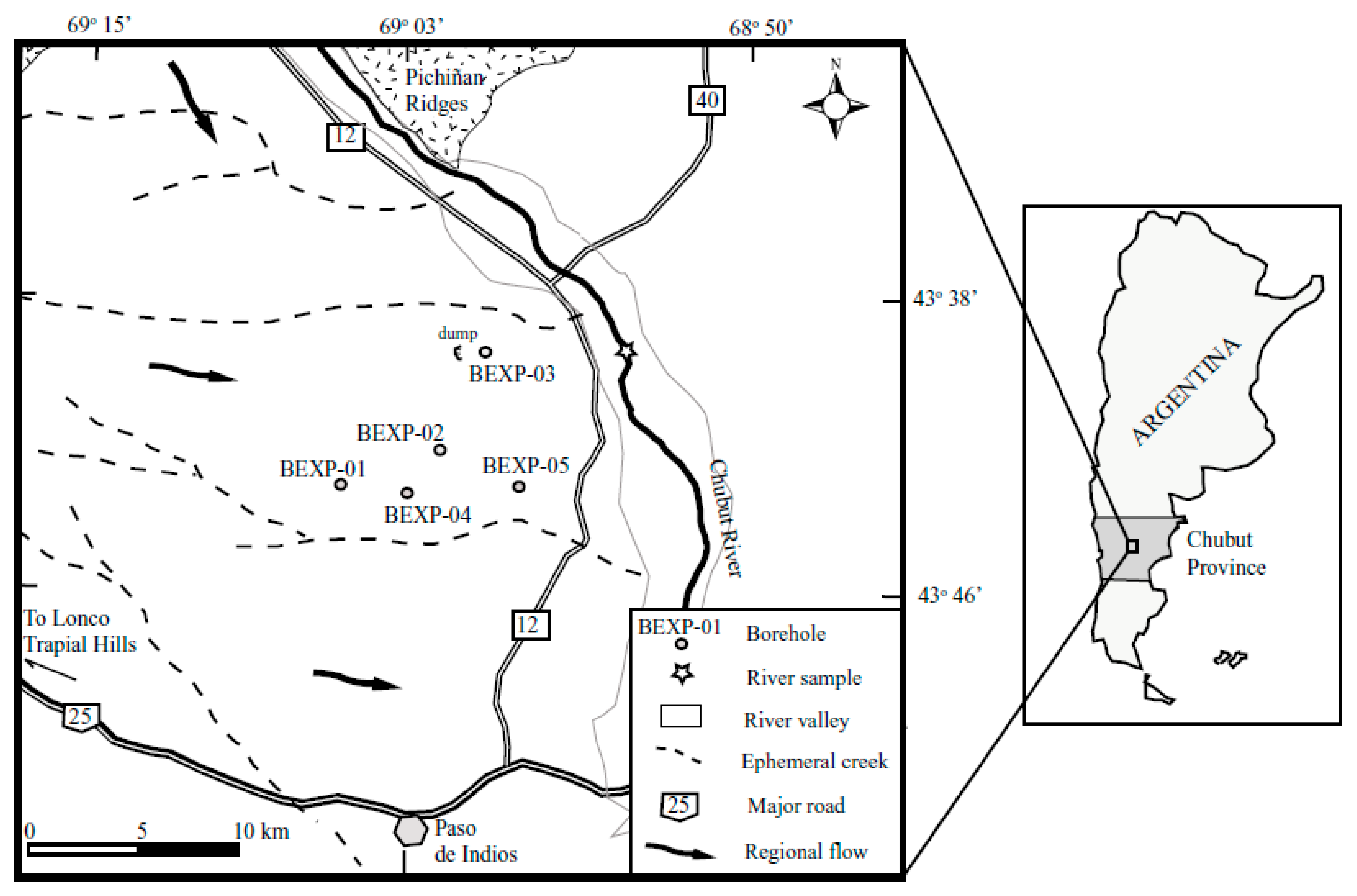
2. Study Area
3. Material and Methods
4. Results and Discussion
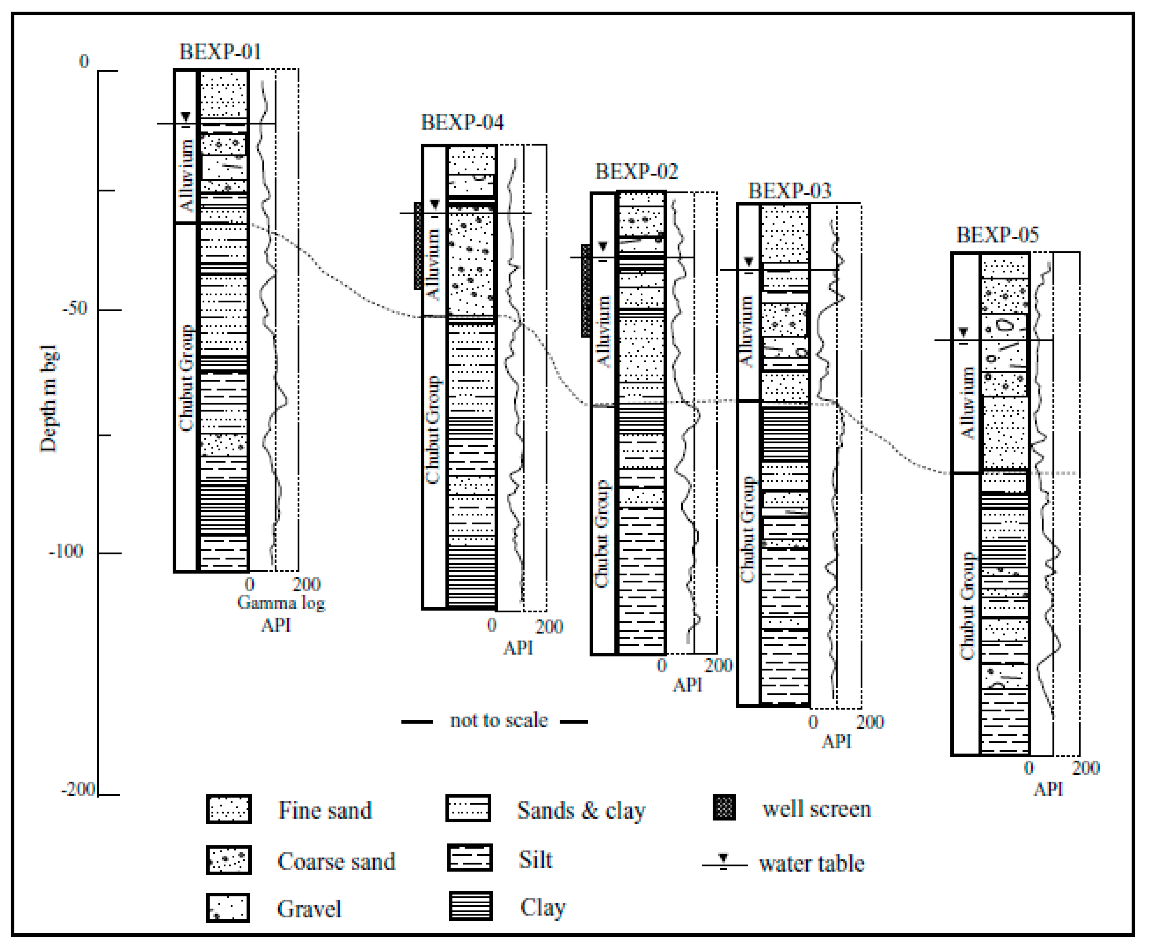
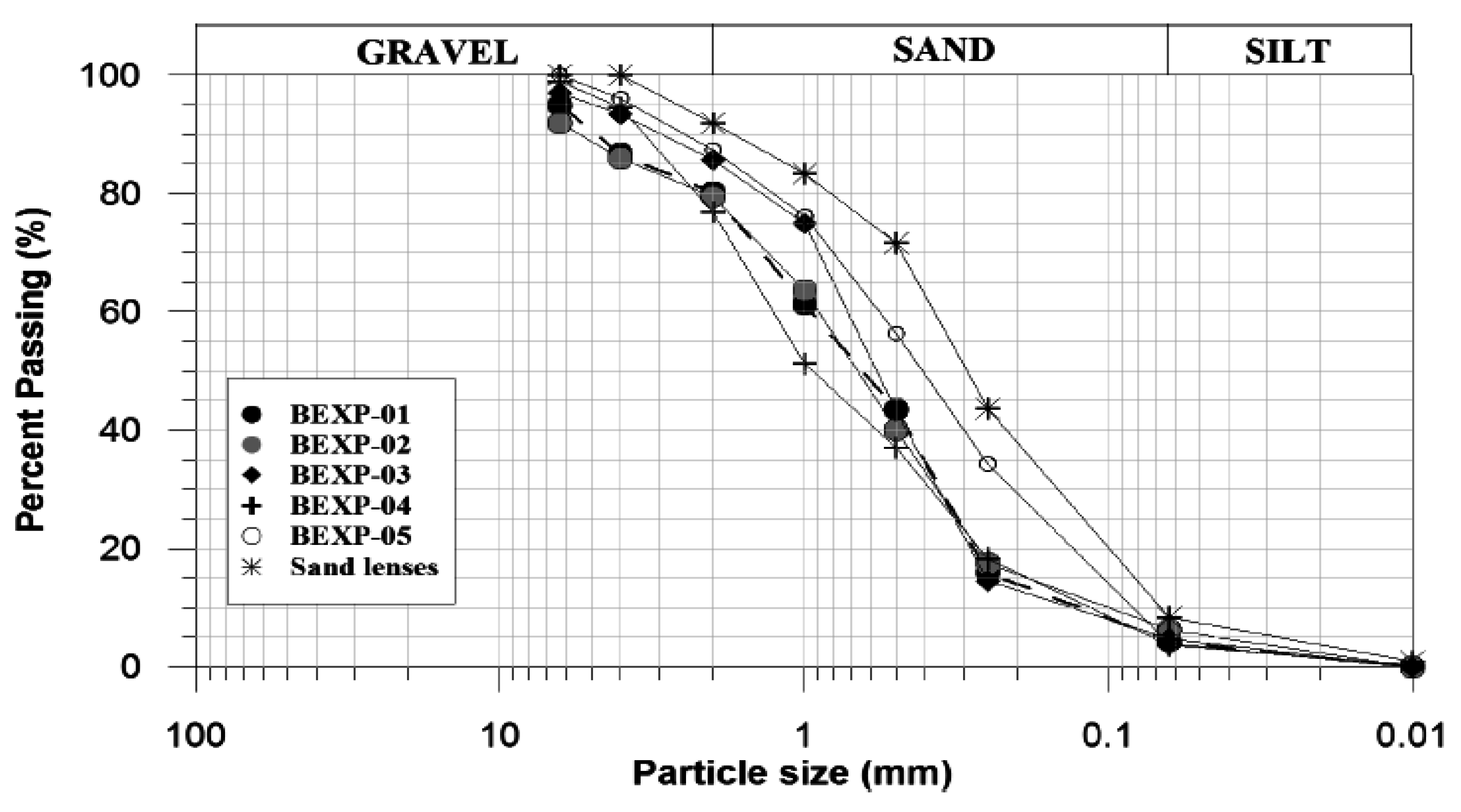
4.1. Geology
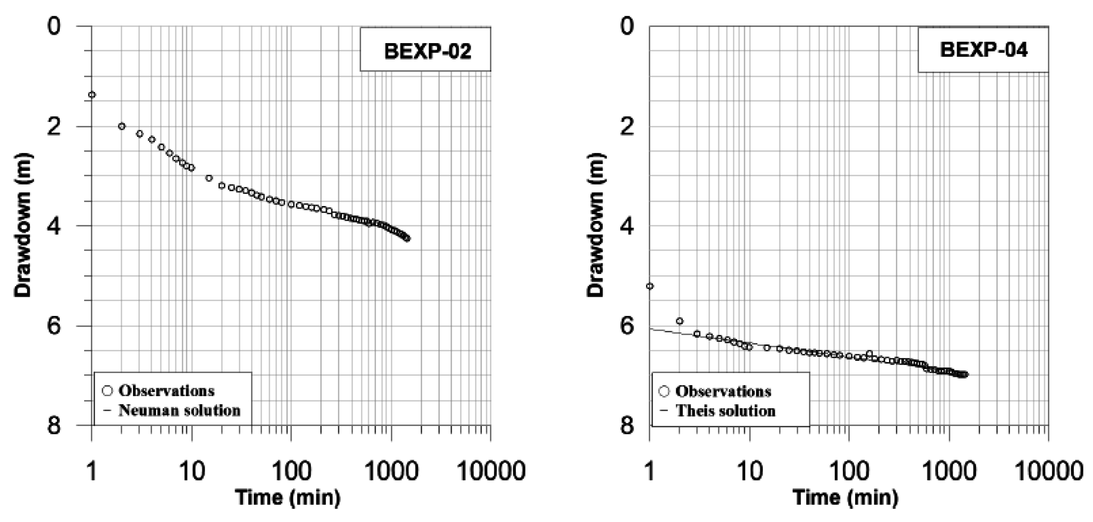
4.2. Hydrogeology
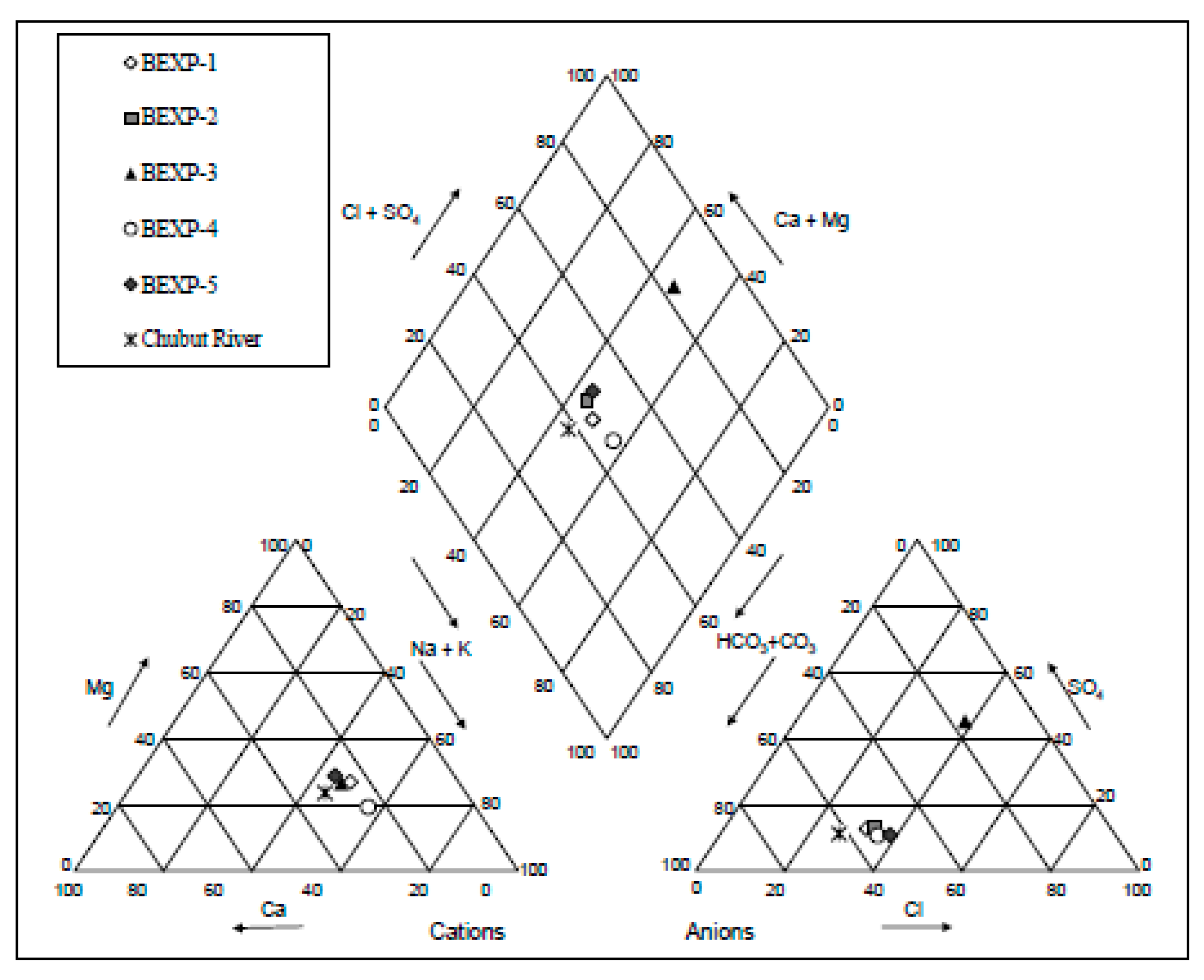
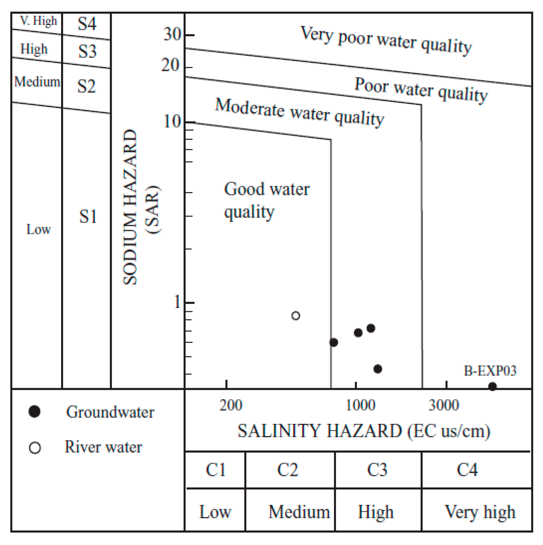
4.3. Geochemistry
5. Study Limitations
6. Concluding Remarks
Acknowledgments
Conflicts of Interest
References
- Wang, Q.; Wu, J.; Lei, T.; He, B.; Wu, Z.; Liu, M.; Mo, X.; Geng, G.; Li, X.; Zhou, H.; et al. Temporal-spatial characteristics of severe drought events and their impact on agriculture on a global scale. Quat. Int. 2014, 349, 10–21. [Google Scholar] [CrossRef]
- Owen Jones, R. The Welsh language in Patagonia. In Language and Community in the Nineteenth Century; Jenkins, G.H., Ed.; University of Wales Press: Cardiff, UK, 1998; pp. 289–290. [Google Scholar]
- Rimoldi, P. Producción ovina en Chubut. IDIA XXI 2004, 4, 10–15. (In Spanish) [Google Scholar]
- Ares, J.; Beeskow, A.M.; Bertiller, M.; Rostagno, M.; Irrisarri, M.; Anchorena, J.; Defosse, G.; Merino, C. Structural and dynamic characteristics of overgrazed lands of Northern Patagonia, Argentina. In Managed Grasslands: Regional Studies; Bremeyer, A., Ed.; Elsevier: Amsterdam, The Netherlands, 1990; pp. 149–175. [Google Scholar]
- Bakker, K. Water security: Research challenges and opportunities. Science 2012, 337, 914–915. [Google Scholar] [CrossRef] [PubMed]
- Torcuato Di Tella Fundación. Comunicación nacional de cambio climático: Vulnerabilidad de la Patagonia y sur de las provincias de Buenos Aires y La Pampa. Informe Final; Fundación Torcuato Di Tella e Instituto Torcuato Di Tella: Buenos Aires, Argentina, 2006; p. 368. (In Spanish) [Google Scholar]
- Méndez, P.M. The hidden face of the Patagonia Argentina. PASOS. Rev. Tur. Patrim. Cult. 2010, 8, 627–631. [Google Scholar]
- Petersen, C.S. Estudios Geológicos en la Región del rio Chubut Medio; Secretaría de Industria y Comercio, Dirección General de Minas y Geología: Buenos Aires, Argentina, 1946; p. 202. (In Spanish) [Google Scholar]
- Aragón, E.; Mazzoni, M.M. Geología y estratigrafía del complejo volcánico piroclastico del rio Chubut medio (Eoceno), Chubut, Argentina. Rev. Asoc. Geol. Argent. 1997, 52, 243–256. (In Spanish) [Google Scholar]
- Moyano, C.H.; Moyano, M.C. Estudio hidrológico del rio Chubut. Cuenca superior y media. Contrib. Cient. GAEA 2013, 25, 149–164. (In Spanish) [Google Scholar]
- Auge, M.; Wetten, C.; Baudino, G.; Bonorino, G.; Gianni, R.; González, N.; Griznik, M.; Hernández, M.; Rodríguez, J.; Tineo, A.; et al. Hidrogeología de Argentina. Bol. Geol. Min. 2006, 117, 7–23. [Google Scholar]
- Scarpini, M.C.; Orfila, J.D. Características de las aguas subterráneas de la provincia del Chubut. Direccion de Proteccion Ambiental, Provincia de Chubut, Argentina, 2005. Available online: http://www.infogranjas.com.ar (accessed on 5 February 2016).
- Sánchez, R.M.; Dunel Guerra, L.; Scherger, M. Evaluación de las áreas bajo Riego Afectadas por Salinidad y/o Sodicidad en Argentina; Programa Nacional del Agua; INTA Publications: Buenos Aires, Argentina, 2015; p. 65. (In Spanish) [Google Scholar]
- Beltramonte, C.; Del Valle, H.F. Reconocimiento de los recursos naturales y el medio ambiente de la región Noreste del Chubut Republica Argentina. In Centro Nacional Patagónico, Contribución No. 47; CONICET Publications: Chubut, Argentina, 1981; p. 33. (In Spanish) [Google Scholar]
- INTA, Instituto Nacional de Tecnología Agropecuaria. Atlas de Suelos de la Republica Argentina. Escala 1:500,000/1:1,000,000; INTA Publications: Buenos Aires, Argentina, 1995. (In Spanish) [Google Scholar]
- Acebal, M. Proyecto de reforzamiento de la producción caprina de mohair en el Norte de la Patagonia Argentina. Programa Mohair 2007. Unpublished. (In Spanish) [Google Scholar]
- HydroSolve, Inc. AQTESOLV pumping test software. Available online: http://www.aqtesolv.com (accessed on 5 May 2016).
- Cabaleri, N.; Volkheimer, W.; Armella, C.; Gallego, O.; Silva Nieto, D.; Páez, M.; Cagnoni, M.; Ramos, A.; Panarello, H.; Kouharsky, M. Estratigrafía, análisis de facies y paleambientes de la formación Cañadón Asfalto, en el depocentro Jurasico Cerro Cóndor, Provincia del Chubut. Rev. Asoc. Geol. Argent. 2010, 66, 349–367. (In Spanish) [Google Scholar]
- Marveggio, N.; Llorens, M. Nueva edad de la base del Grupo Chubut en la mena uranífera Cerro Solo, Provincia del Chubut. Rev. Asoc. Geol. Argent. 2013, 70, 318–326. (In Spanish) [Google Scholar]
- Shepperd, R.G. Correlations of permeability and grain size. Ground Water 1989, 27, 633–638. [Google Scholar] [CrossRef]
- Hazen, A. Discussion: Dams on sand foundations. Trans. Am. Soc. Civil Eng. 1911, 73, 199. [Google Scholar] [CrossRef]
- Brassington, R. Field Hydrogeology, 3rd ed.; John Wiley & Sons: Chichester, UK, 2007; p. 264. [Google Scholar]
- Younger, P.L. Groundwater in the Environment: An Introduction; Blackwell Publishing Ltd.: Oxford, UK, 2007; p. 336. [Google Scholar]
- Uma, K.O.; Egboka, B.C.E.; Onuoha, K.M. New statistical grain-size method for evaluating the hydraulic conductivity of sandy aquifers. J. Hydrol. 1989, 108, 343–346. [Google Scholar] [CrossRef]
- Nievas, H.O.; Caruso, M.; Pizzio, F.; Ferri, F.O.; Pérez, S. Monitoreo ambiental de aguas superficiales y subterráneas, consideración de áreas sensibles, distrito uranífero Pichiñan este, departamento Paso de Indios, provincia del Chubut. Rev. Asoc. Geol. Argent. 2013, 70, 327–334. (In Spanish) [Google Scholar]
- Krautkramer, F.M. Hydrogeology of the Pacific Northwest. A Summary Discussion. In NGWA Pacific NW Expo; Robinson Noble Inc.: Portland, OR, USA, 2012; p. 78. [Google Scholar]
- Jacob, C.E. Drawdown test to determine effective radius of artesian well. Trans. Am. Soc. Civil Eng. 1947, 112, 1047–1070. [Google Scholar]
- Boulton, N.S. Analysis of data from non-equilibrium pumping tests allowing for delayed yield from storage. Proc. Inst. Civil Eng. 1963, 26, 469–482. [Google Scholar] [CrossRef]
- Kruseman, G.P.; de Ridder, N.A. Analysis and Evaluation of Pumping Test Data; Pudoc: Wagening, The Netherlands, 1990; p. 377. [Google Scholar]
- Neuman, S.P. Effect of partial penetration on flow in unconfined aquifers considering delayed gravity response. Water Resour. Res. 1974, 10, 303–312. [Google Scholar] [CrossRef]
- Theis, C.V. The relation between the lowering of the piezometric surface and the rate and duration of discharge of a well using groundwater storage. Am. Geophys. Union Trans. 1935, 16, 519–524. [Google Scholar] [CrossRef]
- Zhu, G.F.; Su, Y.H.; Feng, Q. The hydrogeochemical characteristics and evolution of groundwater and surface water in the Heihe River Basin, northwest China. Hydrogeol. J. 2008, 16, 167–182. [Google Scholar] [CrossRef]
- WHO (World Health Organization). Guidelines for Drinking-Water Quality. Available online: http://www.who.int/water_sanitation_health/publications/2011/dwq_chapters/en/ (accessed on 5 February 2016).
- McGowan, W. Water Processing: Residential, Commercial, Light-Industrial, 3rd ed.; Water Quality Association: Lisle, IL, USA, 2000. [Google Scholar]
- Evens, E.; Yanick, S.; Osnick, J. Characterization of hardness in the groundwater of Port-Au-Prince. An overview of the health significance of magnesium in the drinking water. Aqua LAC 2013, 5, 35–43. [Google Scholar]
- ANZECC. Australian and New Zealand Guidelines for Fresh and Marine Water Quality. The Guidelines; Australian Water Association: New South Wales, Australia, 2000; Volume 1, p. 314. [Google Scholar]
- Gowariker, V.; Krishnamurthy, V.N.; Gowariker, S.; Dhanorkar, M.; Paranjape, K. The Fertilizer Encyclopedia; John Wiley & Sons: Hoboken, NJ, USA, 2009; p. 860. [Google Scholar]
- Kumar, A. Water Pollution; A.P.H Publishing Corp.: New Delhi, India, 2004; p. 349. [Google Scholar]
- Shahabi, A.; Malakouti, M.J.; Fallahi, E. Effects of bicarbonate content of irrigation water on nutritional disorders of some apple varieties. J. Plant Nutr. 2005, 28, 1663–1678. [Google Scholar] [CrossRef]
- Richards, L.A. Diagnosis and Improvement of Saline and Alkaline Soils. In United States Salinity Laboratory Staff. Agricultural Handbook No. 60; United States Department of Agriculture: Washington, DC, USA, 1954; pp. 1–160. [Google Scholar]
- Jarsun, O.; Bustos, V.; Carnero, M. Manual de uso e Interpretación de Aguas. Provincia de Córdoba; Report prepared by the Secretary of Environment of Cordoba: Cordoba, Argentina, 2008; p. 50. [Google Scholar]
- Maas, E.V. Crop salt tolerance. In Agricultural Salinity Assessment and Management, ASCE Manuals and Reports on Engineering Practice 71; Tanjii, K.K., Ed.; ASCE: New York, NY, USA, 1990; pp. 262–304. [Google Scholar]
- Código Alimentario Argentino. Normas Oficiales Para la Calidad del Agua Argentina. Disposiciones de la ley 18.284. Available online: http://www.cdaguas.com.ar/pdf/aguas/24_Normas_oficiales.pdf (accessed on 5 February 2016).
- Hanson, R.T.; Nishikawa, T. Combined use of flowmeter and time-drawdown data to estimate hydraulic conductivities in layered aquifer systems. Ground Water 1996, 34, 84–94. [Google Scholar] [CrossRef]
- Sander, P. Lineaments in groundwater exploration: A review of applications and limitations. Hydrogeol. J. 2007, 15, 71–74. [Google Scholar] [CrossRef]


| Borehole | Aquifer | d10 (mm) | d50 (mm) | Hazen K (m/day) | Pumping Test K (m/day) |
|---|---|---|---|---|---|
| BEXP-01 | Alluvium | 0.15 | 0.65 | 15.8 | - |
| BEXP-02 | Alluvium | 0.10 | 0.70 | 7.0 | 3.0 |
| BEXP-03 | Alluvium | 0.15 | 0.60 | 15.8 | - |
| BEXP-04 | Alluvium | 0.13 | 0.95 | 11.8 | 10.3 |
| BEXP-05 | Alluvium | 0.08 | 0.40 | 4.5 | - |
| BEXP-05 | Chubut Group | 0.07 | 0.30 | 3.3 | - |
| Bore | Time (min) | Discharge L/s | Maximum Observed Drawdown Sw (m) | Predicted 1-Year Drawdown (m) | Formation Loss BQ (m) | Well Loss CQ2 (m) | Bore Efficiency % |
|---|---|---|---|---|---|---|---|
| BEXP-02 | 100 | 2 | 1.2 | 1.3 | 1.0 | 0.2 | 80 |
| 200 | 3 | 2.1 | 4.5 | 1.5 | 0.6 | 73 | |
| 300 | 4 | 3.3 | 6.9 | 2.1 | 1.1 | 67 | |
| 400 | 5.5 | 4.5 | 18.0 | 2.7 | 1.9 | 59 | |
| BEXP-04 | 100 | 2 | 1.10 | 1.4 | 0.70 | 0.4 | 63 |
| 200 | 3 | 2.05 | 4.0 | 1.0 | 0.95 | 53 | |
| 300 | 4 | 3.15 | 6.8 | 1.40 | 1.75 | 45 | |
| 400 | 5 | 4.5 | 19.5 | 1.4 | 3.1 | 30 |
| BEXP-1 | BEXP-2 | BEXP-3 | BEXP-4 | BEXP-5 | Chubut River | ||
|---|---|---|---|---|---|---|---|
| Al | mg/L | 0.08 | 0.09 | 0.1 | 0.08 | 0.08 | - |
| As | mg/L | - | - | - | - | - | - |
| B | mg/L | 0.09 | 0.09 | 0.12 | 0.11 | 0.09 | 0.07 |
| Cd | mg/L | - | - | - | - | - | - |
| Mn | mg/L | 0.31 | 0.33 | 0.35 | 0.12 | 0.2 | 0.09 |
| HCO32− | mg/L | 115 | 104 | 95 | 114 | 89 | 84 |
| Ca | mg/L | 18 | 22 | 55 | 18.5 | 17 | 15.5 |
| Cl | mg/L | 39 | 38 | 126 | 44 | 39 | 21 |
| F | mg/L | 0.2 | 0.2 | 0.4 | 0.26 | 0.2 | 0.1 |
| Mg | mg/L | 12 | 10 | 33 | 9 | 11 | 7 |
| K | mg/L | 5.3 | 4 | 7.9 | 3 | 2 | 0.1 |
| Si | mg/L | 9.5 | 6.8 | 7.1 | 8.6 | 13.2 | 3.6 |
| Na | mg/L | 38 | 33 | 106 | 48 | 31 | 25 |
| SO42− | mg/L | 21 | 20 | 203 | 18 | 15 | 12 |
| NO3− | mg/L | <5 | <5 | 45 | <5 | <5 | <5 |
| EC | µS/cm | 907 | 1135 | 4300 | 1400 | 1300 | 640 |
| TDS | mg/L | 499 | 624 | 2365 | 770 | 715 | 352 |
| Hardness (as CaCO3) | mg/L | 94.3 | 96.1 | 109.3 | 83.2 | 87.7 | 67.5 |
| Alkalinity (as CaCO3) | mg/L | 94.3 | 85.2 | 77.9 | 93.5 | 72.9 | 68.9 |
| pH | 7.4 | 7.6 | 7.1 | 7.6 | 7.4 | 6.9 |
| Borehole | Salinity | Na+ | B | Cl− | HCO3− | NO3− | Hardness |
|---|---|---|---|---|---|---|---|
| BEXP-01 | High (C3) | Low (S1) | Low | Low | Low | Low | Moderate |
| BEXP-02 | High (C3) | Low (S1) | Low | Low | Low | Low | Moderate |
| BEXP-03 | Very high (C4) | Low (S1) | Low | Low | Low | High | Moderate |
| BEXP-04 | High (C3) | Low (S1) | Low | Low | Low | Low | Moderate |
| BEXP-05 | High (C3) | Low (S1) | Low | Low | Low | Low | Moderate |
| Chubut River | Medium (C2) | Low (S1) | Low | Low | Low | Low | Moderate |
© 2016 by the author; licensee MDPI, Basel, Switzerland. This article is an open access article distributed under the terms and conditions of the Creative Commons Attribution (CC-BY) license (http://creativecommons.org/licenses/by/4.0/).
Share and Cite
Gallardo, A.H. Groundwater Exploration for Rural Water Supply in an Arid Region of Southern Argentina. Geosciences 2016, 6, 28. https://doi.org/10.3390/geosciences6020028
Gallardo AH. Groundwater Exploration for Rural Water Supply in an Arid Region of Southern Argentina. Geosciences. 2016; 6(2):28. https://doi.org/10.3390/geosciences6020028
Chicago/Turabian StyleGallardo, Adrian H. 2016. "Groundwater Exploration for Rural Water Supply in an Arid Region of Southern Argentina" Geosciences 6, no. 2: 28. https://doi.org/10.3390/geosciences6020028