Moroccan Groundwater Resources and Evolution with Global Climate Changes
by
 , ,
, ,
Mohammed Hssaisoune
1,2,* ,
,
Lhoussaine Bouchaou
3,4,
Abdelfattah Sifeddine
5,6,
Ilham Bouimetarhan
1,7 and
Abdelghani Chehbouni
4,8 1
Faculty of Applied Sciences, Ibn Zohr University, Ait Melloul 86153, Morocco
2
GEVARET-FST, Sultan Moulay Slimane University, Béni Mellal 23000, Morocco
3
Laboratory of Applied Geology and Geo-Environment, Ibn Zohr University, Agadir 80035, Morocco
4
International Water Research Institute, Mohammed VI Polytechnic University, Ben Guerir 43150, Morocco
5
Institut de recherche pour le développement France-Nord, LOCEAN - IPSL UMR 7159, IRD-Sorbonne Universités (Université P. et M. Curie, Paris 06) -CNRS/UPMC/IRD, 75000 Paris, France
6
LMI PALEOTRACES, IRD-UFF-UANTOF-UPCH, Universidad Federal Fluminense, Niteroi 24020-091, Rio de Janeiro, Brazil
7
MARUM—Center for Marine Environmental Sciences, University of Bremen, D-28359 Bremen, Germany
8
CESBIO, Université de Toulouse, CNRS, CNES, IRD, BPI 280, 31065 Toulouse CEDEX 9, France
*
Author to whom correspondence should be addressed.
Geosciences 2020, 10(2), 81; https://doi.org/10.3390/geosciences10020081
Submission received: 18 January 2020
/
Revised: 7 February 2020
/
Accepted: 19 February 2020
/
Published: 22 February 2020
(This article belongs to the Special Issue Groundwater in arid and semiarid areas)
Abstract
:In semi-arid areas, many ecosystems and activities depend essentially on water availability. In Morocco, the increase of water demands combined to climate change induced decrease of precipitation put a lot of pressure on groundwater. This paper reports the results of updating and evaluation of groundwater datasets with regards to climate scenarios and institutional choices. The continuous imbalance between groundwater extraction and recharge caused a dramatic decline in groundwater levels (20 to 65 m in the past 30 years). Additionally, Morocco suffers from the degradation in groundwater quality due to seawater intrusion, nitrate pollution and natural salinity changes. Climate data analysis and scenarios predict that temperatures will increase by 2 to 4 °C and precipitation will decrease by 53% in all catchments over this century. Consequently, surface water availability will drastically decrease, which will lead to more extensive use of groundwater. Without appropriate measures, this situation will jeopardize water security in Morocco. In this paper, we zoom on the case the Souss-Massa basin, where management plans (artificial recharge, seawater desalination, and wastewater reuse) have been adopted to restore groundwater imbalance or, at least, mitigate the recorded deficits. These plans may save water for future generations and sustain crop production.
1. Introduction
In arid and semi-arid regions, large aquifer systems are often overexploited and used as an additional water source for different needs (e.g., source of drinking water for both urban and rural centers) [1,2]. If groundwater pumping exceeds the natural recharge over an extensive area and a long time period, persistent groundwater depletion occurs [1,3].
Morocco is a semi-arid Mediterranean country with scarce and irregular precipitation; thus, surface water and groundwater resources are important for socio-economic development [4]. For this reason, aquifers are intensively exploited to satisfy growing agricultural, industrial, tourism and domestic needs [5,6,7]. Accelerating industrial activities in combination with rapid population growth and agricultural intensification has led to a substantial increase in groundwater depletion and degradation of quality [8].
The current total renewable water resources of Morocco (surface and groundwater) are estimated at 29 billion cubic meters (BCM) per year [9]. The utilizable component is 20 BCM, with 16 BCM from surface water and 4 BCM from groundwater. About 70% of this potential is currently exploited (i.e., 11 BCM of surface water and 2.7 BCM of groundwater) [9].
The depletion of groundwater aquifers is a major issue in Morocco and is a particular concern for water managers and other decision makers. Rapid declines in groundwater levels (0.5 to 2 m per year in average) are generally the result of (1) low groundwater recharge and (2) over-expansion of agricultural activities [10,11].
The Souss-Massa and Drâa basins represent typical cases and are strongly impacted by climate variability and anthropogenic activity, and subject to high variations on many scales [6,8,10,12,13,14]. In these basins, the most important issues that affect groundwater recharge in these basins include the intermittent flow of rivers, decreasing capacity of reservoirs, water release from dams, removal of groundwater through pumping, soil salinity in irrigated areas, overgrazing, deforestation and the spread of an epiphytic fungal disease (Bayoud disease) in the palm date [15]. Moreover, the area around these basins experience human socioeconomic issues, such as competition for water use, droughts and land degradation that triggers the movement of people.
Despite these issues, the Souss-Massa basin is a good example of effective quantitative and qualitative management of groundwater resources under the combined pressures of climate change and human activities.
This study (1) provides an overview of groundwater management in Morocco using recent scientific results and the outcome of governmental and non-governmental investigations, (2) reports the impact of global change on groundwater in the most arid basins in Morocco and (3) describes the National Water Strategy (NWS) and adaptations proposed by the Moroccan government.
2. Materials and Methods
2.1. Study Area
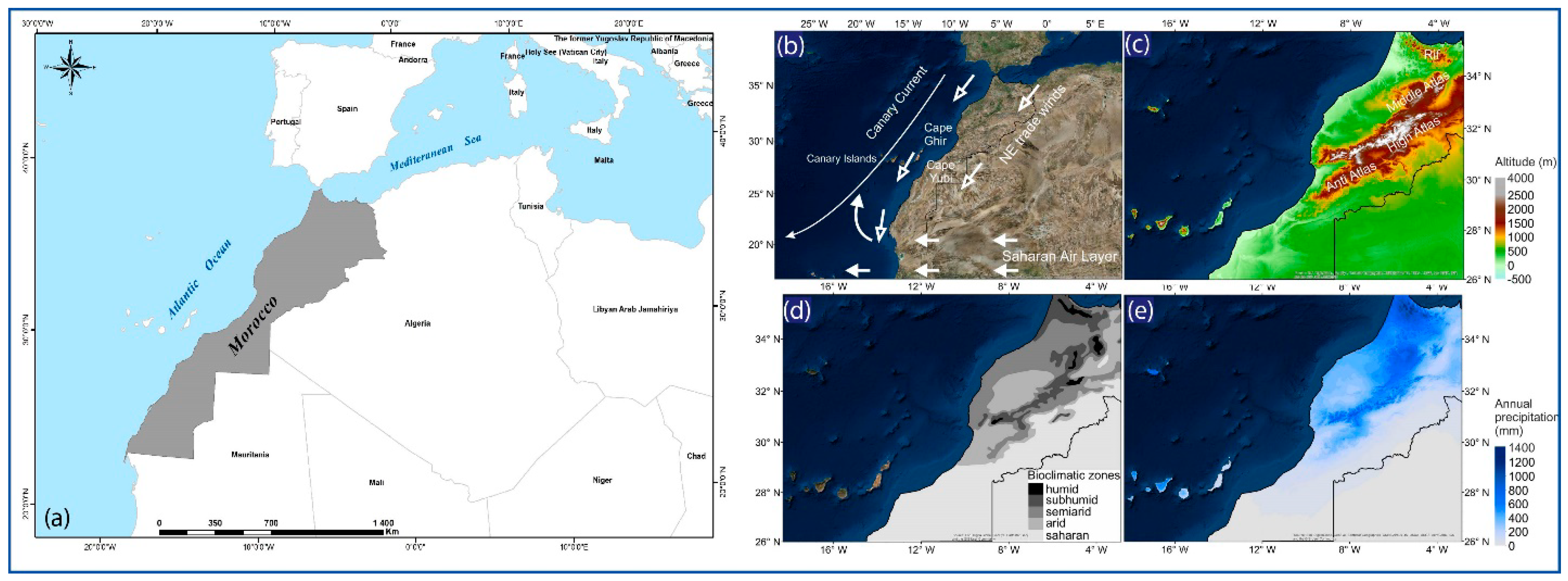
Morocco is located in northwestern Africa on the edge of continental Europe, and is bordered by the Atlantic Ocean to the west, Algeria to the east, Mauritania to the south and the Mediterranean Sea to the north (Figure 1a).
Four mountain chains dominate the topography and divide the country into three geographic regions: the mountainous interior, including plateaus and fertile valleys; Atlantic coastal lowlands; semi-arid and arid areas of eastern and southern Morocco, where the mountains descend gradually into the Sahara Desert.
In the north, the Rif mountain range runs parallel to the Mediterranean Sea. South of the Rif mountains, a series of three Atlas mountain ranges somewhat overlap one another across the country on a generally ENE–WSW axis that separates the Mediterranean and Atlantic coastal regions from the Sahara Desert (Figure 1c).
Presently, Moroccan climate is mainly controlled by three different climate systems, the humid Mediterranean and Atlantic climates in the north and northwest and the arid Saharan climate in the south [16]. These climate systems define five bioclimatic zones: humid; sub-humid; semi-arid; arid and Saharan (Figure 1b,d). In general, precipitation decreases from north to south and from west to east. The northwestern region receives the greatest amount of precipitation where the annual average rainfall exceeds 1000 mm in the northern Rif, Middle and High Atlas Mountains; precipitation is less than 200 mm in most other parts of Morocco (Figure 1e).
The Souss-Massa and Drâa basins are located in the southern part of Morocco, are one of the country’s most important socioeconomic areas (Figure 2a), and evaluated here because: (1) its geographical situation in South of Atlas Mountains (natural barrier of Mediterranean and North Atlantic moist air masses), (2) groundwater is vital because of quasi-absence of surface water, (3) global climate changes, (4) and successful groundwater management solutions under global changes.
2.2. Methods
Our initial focus was on the collection and updating of existing datasets. Water supply/demand data were extracted from the FAO’s AQUASTAT database. Climate and hydrogeological data were collected from local meteorological stations and from piezometers within the Souss-Massa, Tadla, Haouz and Saïs aquifers, under the authority of public organizations especially the hydraulic agencies. Time series data of rainfall were analyzed using annual mean and 5-year running mean over 1933–2015 at five meteorological stations (Agadir, Taroudant, Tiznit and Aoulouz in the Souss Basin and M’smrir in the Drâa Basin). The other Drâa stations had relatively short measuring times. We used simple linear regression to estimate the linear trend for each meteorological station.
In addition, 282 water samples from different parts of four main basins (Souss-Massa, Tadla, Drâa and Ziz) provided information about the groundwater quality in these basins. Most sampled wells were Plio–Quaternary shallow aquifers and deep confined Turonian aquifers. Samples were collected during field campaigns between 2009 to 2012, supported within the NATO Project.
Literature research and field observations that spanned a period of more than 20 years. We focus on two arid basins (Souss-Massa and Drâa). The Souss-Massa and Drâa aquifers are used predominantly for agriculture, but also support drinking and agro-food water production, agricultural irrigation, tourism, oasis ecosystems, and rangeland.
We also performed a qualitative analysis of legislative and governance actions to describe the evolution of law and institutional reforms surrounding the use of water resources.
The objective was to show how updates to data and subsequent laws are linked and very important for the use of groundwater as a strategic water resource for sustainable development. Successful case studies provide useful guidelines for current and future stakeholders.
3. Global Changes and Groundwater at National Level
3.1. Major Aquifers
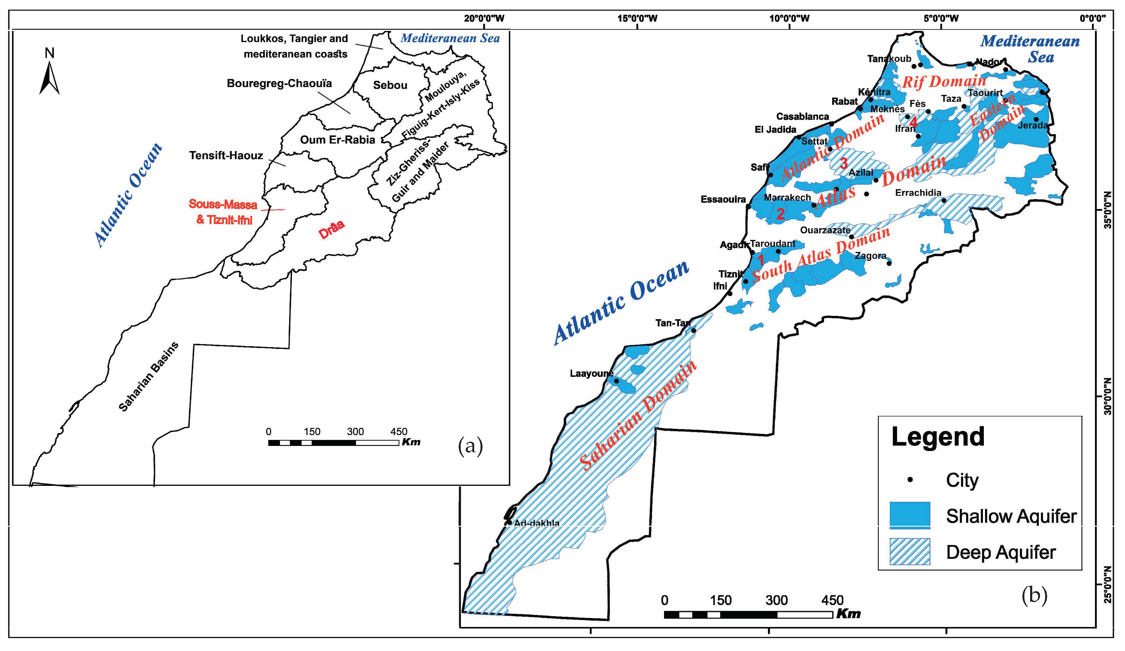
In Morocco, groundwater is available within unconsolidated material (e.g., gravel, sand, or silt), fractured rocks (e.g., granite, schist), weathered rocks, karst, and many geological formations throughout the country. The local availability of groundwater is dependent on the water-bearing properties of the subsurface geology and recharge. Due to its geological diversity, Morocco offers a wide range of hydrogeological environments [17].
Six major hydrogeological domains can be identified (Figure 2b): Saharan; South Atlas, including the Anti-Atlas; Atlas, including the High and Middle Atlas; Eastern in the northeast (Eastern Meseta); Atlantic in the Western Meseta, along the Atlantic coast; Rif in the north. Within each of these domains, there are similarities in geology and climate, but groundwater exists in different geological environments.
There are 32 deep aquifers (200 to 1000 m below surface) and more than 98 shallow aquifers (<200 m) (Figure 2). The deep aquifers are often not accessed because of the high economic cost of drilling. The shallow aquifers are more accessible, but also more vulnerable to climate change, overexploitation, pollution, and evaporation [10].
3.2. Quantitative Groundwater Evolution
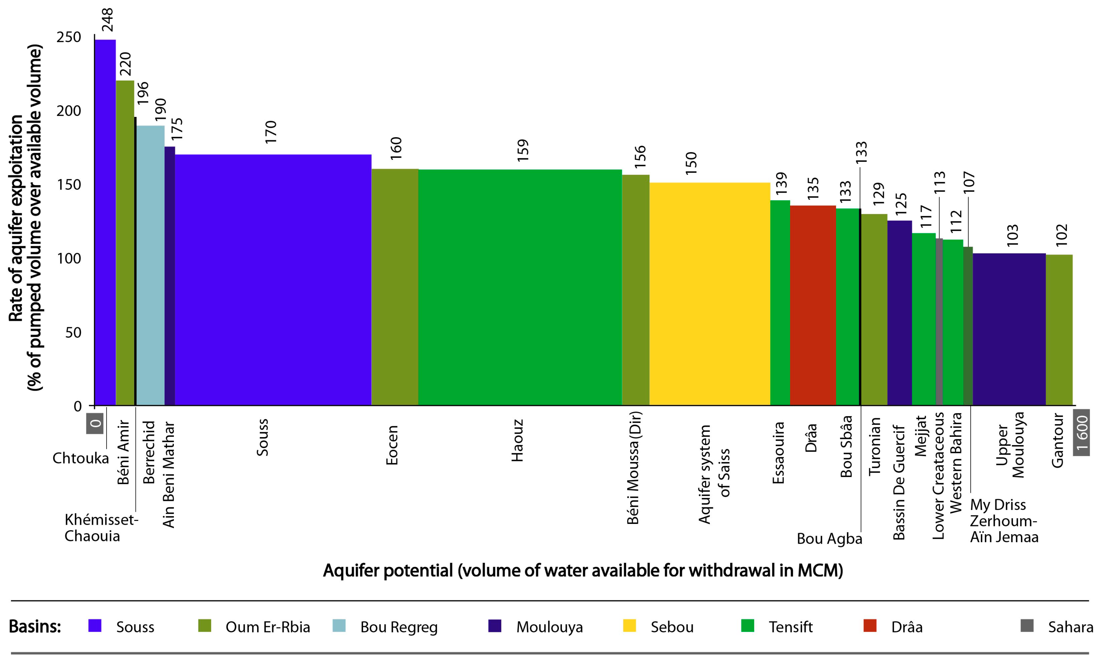
In Morocco, 80% to 95% of water resources are used in agriculture with at least 40% originating from groundwater. This groundwater proportion exceeds 70% in the southern basins [18,19,20]. Groundwater budgets show that a total of 4226 million cubic meter (MCM) of water is extracted annually, against a renewal potential of about 3404 MCM (Table 1). This indicates an annual groundwater deficit of about 862 MCM for the entire country, but the situation varies among the different basins and from north to south (Table 1). Moreover, climate change models forecast that drought intensification in the future will aggravate the groundwater crisis [14].
Figure 3 summarizes the balance between groundwater extraction and recharge that range from 100% (Moulouya) to 248% (Chtouka-Massa). This disequilibrium caused a dramatic decline in groundwater levels (20 to 65 m) over all basins in the last 30 years, including the Souss, Haouz, Tadla and Saïss plains [10,22,23]. This depletion is related to over-extraction and low recharge from decreasing precipitation. Large aquifers, in terms of groundwater storage (e.g., Tadla, Souss, Haouz and Saïs), showed a deficit of 150% to 170% that can be explained by intensive agricultural. We note that these aquifer systems are recharged mainly from the Atlas Mountains, which are characterized by high rainfall and snow cover. Some of this recharge decline is a consequence of climate change over the last four decades in the area. However, several deficits observed in some areas (e.g., Chtouka, Beni Amir) are related especially to overexploitation. The aquifers with relatively low deficits were those that were recharged from outcrops in the mountains and had low extension that excludes more agricultural activity (upper Moulouya) or just started irrigation development. In addition to increased aridity, the relatively high deficit in the southern basins can be explained in part by the ability in northern areas to use surface water from dams and permanent rivers. In the Souss-Massa basin, for example, water for irrigation is not provided regularly from dams because of arid conditions.
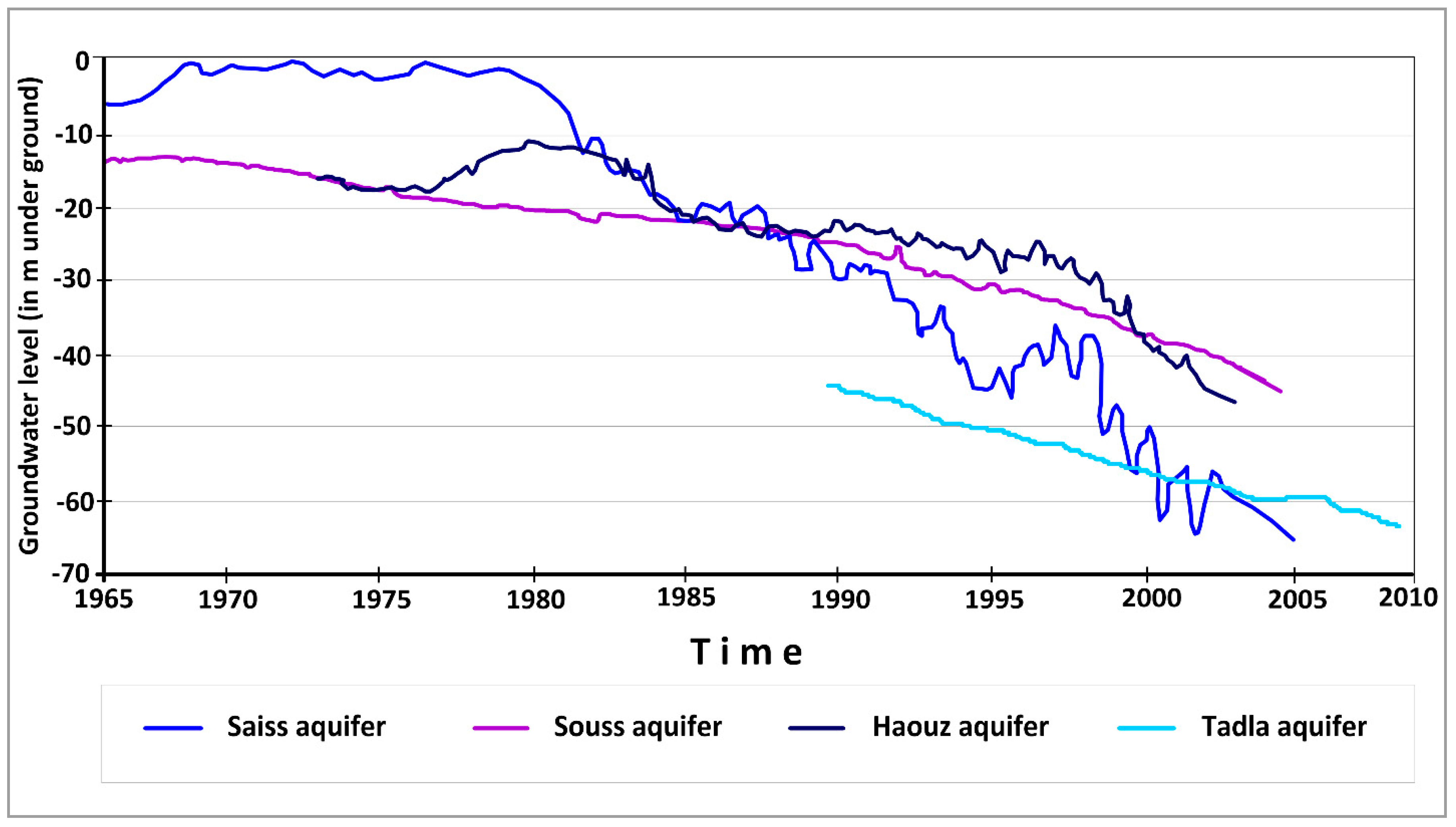
In recent decades, the depletion of groundwater levels is the main issue. Monitoring of water level evolution in almost all of the country’s aquifers showed a continuous decline, sometimes reaching values that may exceed 1–2 m/year. Figure 4 shows that depletions range mainly from 20 to 65 m for several aquifers (e.g., Souss, Houaz, Saïs, Tadla). The Saïs, Souss, Haouz and Tadla basins have been depleted by about 65 m in 60 year, 30 m in 30 year, 30 m in 60 year and 20 m in 20 year, respectively. Within these areas, some of the deep aquifers are not renewable or present limited recharge. Observed seasonal variability is related to some extreme events. Relative increases (Figure 4) were due mainly to rainy season and surface–groundwater interactions. The high amplitude fluctuations in the Saïs aquifer is probably due to karstic features of the Liassic formations. Some aquifers bordering the Atlas Mountains are influenced also by water recharge from snowmelt [24,25,26]. We note that the depletion measured by each piezometer was dependent on its position within the basin. Some piezometers near the river are very sensitive to rainfall and flow discharge.
3.3. Groundwater Quality Degradation
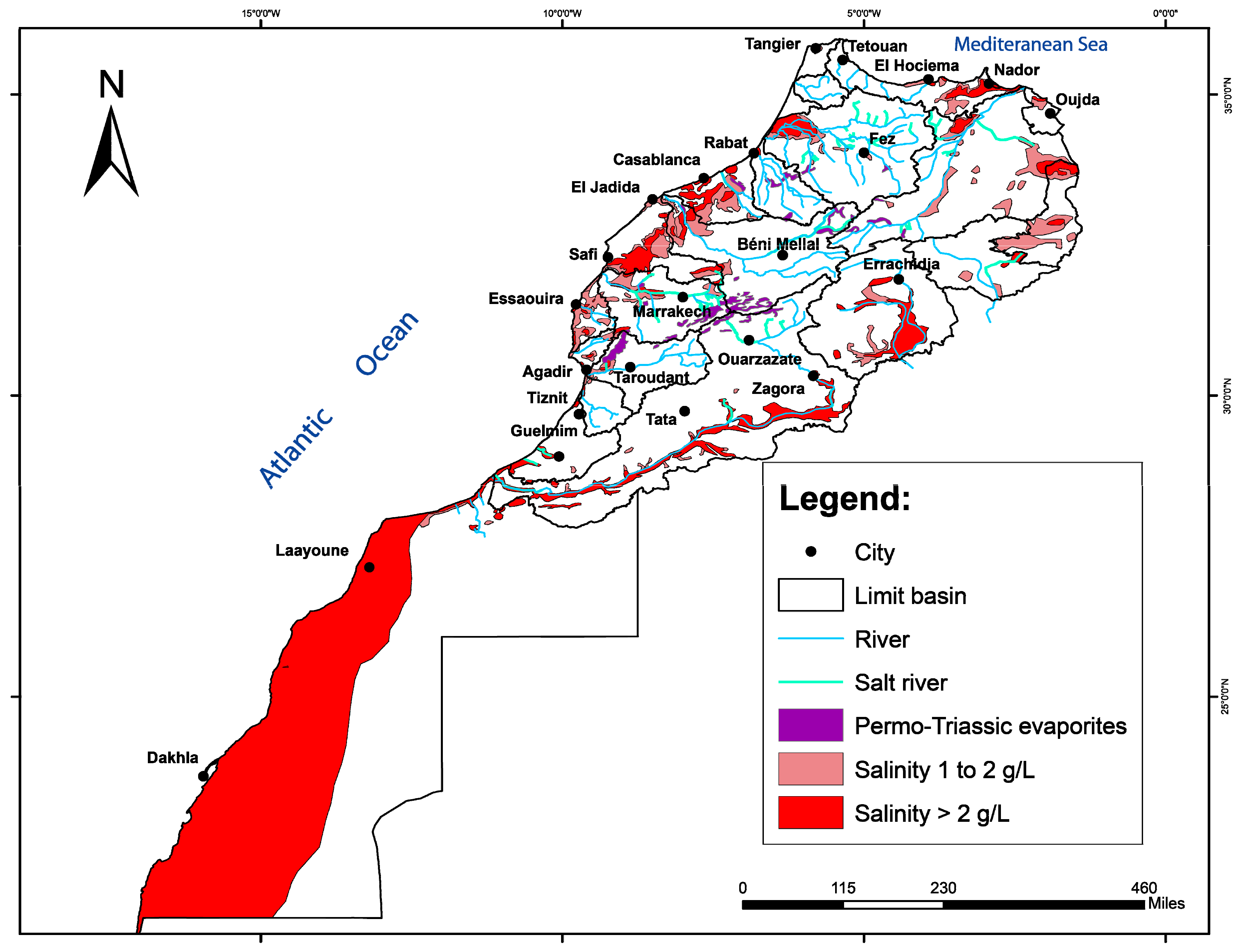
In addition to water scarcity, Morocco suffers from the degradation in groundwater quality, linked to the depletion of groundwater, as well as seawater intrusion, nitrate pollution (fertilizers, sewage, and manure), and natural salinity changes (evaporation and dissolution). Figure 5 summarizes the spatial repartitioning of saline groundwater and shows that the salinization is essentially from natural degradation by Permo-Triassic evaporites, high evaporation, low recharge and seawater intrusions in coastal areas. Salinity increases are aggravated in coastal and irrigated areas by anthropogenic activities. The overall degradation in quality varies among the basins depending on geological context, local climate conditions, and land use.
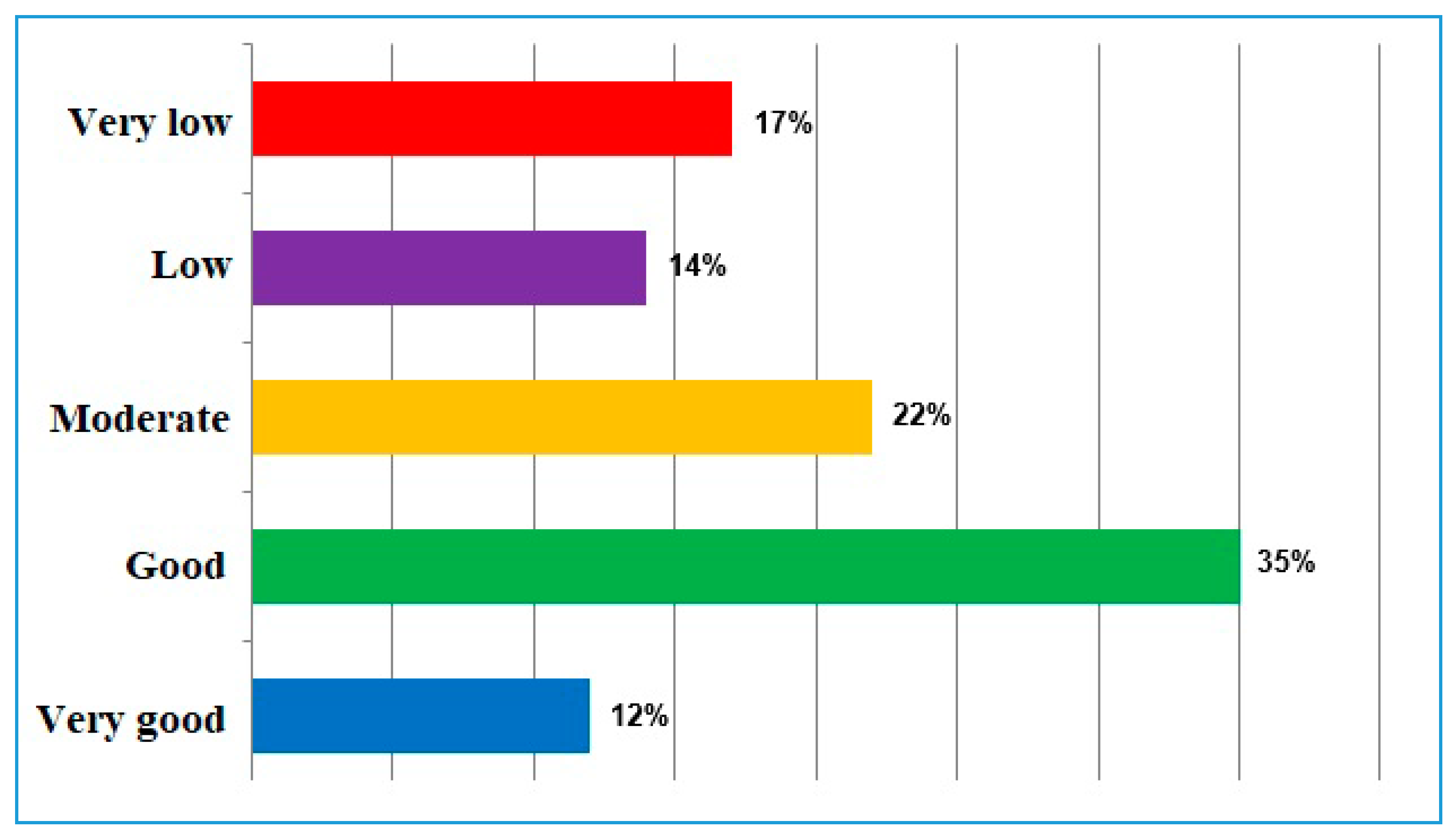
31% of groundwater in Morocco is affected by human pollution or natural degradation (Figure 6, very low and low quality represent 17% and 14%, respectively). Moderate quality groundwater represents 22% while good and very good quality groundwater represents 35% to 12%, respectively.
Generally, mineralization and/or groundwater contamination in Morocco has several origins (natural and/or anthropogenic) and processes (e.g., water–rock interactions, evaporation and seawater intrusion).
3.3.1. Coastal Areas
In the aquifers located along the Mediterranean coast, high mineralization of the groundwater is caused by dissolution processes of Miocene evaporitic rocks and carbonates and human impact from agriculture [27,28,29]. In this area, agricultural activity, and resulting high nitrate, is the main contributor of groundwater contamination. M Seawater intrusion into the Martil and Triffa aquifers also contributes to contamination [29,30,31].
Along the Atlantic coast, many aquifers suffer from seawater intrusion and anthropogenic impacts. The Bouregreg-Chaouia basin (Figure 2a) is a vital water source for the regional population. The groundwater is intensively pumped for irrigation, which increases its vulnerability to salinization and affects its quality. The quality of Chaouia groundwater is affected by high mineralization from seawater intrusion and anthropogenic activities [32]. Over-pumping and over-utilization of fertilizers has led to groundwater degradation (high levels of electrical conductivity, total dissolved solids, chloride and nitrate), which has made most of the water unsuitable for drinking. In the coastal area of the Oum Erbia basin, Mountadar et al. [33] found that the groundwater is also contaminated by seawater intrusion, accompanied by ion exchange based on the hydrogeological characteristics of the area. In the central Tensift-Haouz basin (Figure 2a), several authors [34,35] observed a deterioration in groundwater quality with an increase in salinity from seawater intrusion and nitrate contamination from intensifying agricultural activity. Finally, the Souss-Massa coastal aquifer shows high salinity mainly along the estuaries of the Souss and Massa rivers, which indicates a tidal influence.
In the southern part of Morocco, along the coastal edge of the Sahara, there is high salinity from seawater intrusion and evaporation (e.g., Foum El Oued aquifer).
3.3.2. Inland Aquifers
Inland areas show variable salinities of different origins. The main origin of salinity is related to dissolution of evaporitic Triassic (NaCl) and Jurassic (gypsum) formations, such as Oum Erbia, Souss-Massa, Saïss, and Ziz.
Previous studies investigated groundwater quality and salinization on the Tadla plain (Oum Er-Rbia basin in Figure 2a) and linked water quality deterioration to excessive use of organic and inorganic fertilizers and irrigation wastewater [36,37,38,39,40]. In the Middle Atlas and on the Saïss plain (Sebou basin in Figure 2a) water contamination from anthropogenic sources was identified [41]. While intense agricultural activity has caused nitrates to increase (up to 180 mg/L) in the Saïss aquifer, waters from the Middle Atlas still have good quality.
In southeastern Morocco (Drâa and Ziz-Gheriss-Guir-Maider basins in Figure 2a), chemical and isotopic investigations [19,42] indicated that the main mechanism of groundwater degradation in the shallow aquifers in the Drâa and Tafilalt Oases is via the dissolution of gypsum and halite) in the unsaturated zone of the High Atlas Mountains. The source of nitrate contamination is from excessive use of agricultural fertilizers and septic tanks [43].
In the central part of Morocco (Tensift-Haouz basin in Figure 2a), recent studies [44,45] found that the groundwater on the Tensift plains (Bahira and Haouz) is relatively degraded. Hydrochemical data show geological control on water quality in addition to different anthropogenic activities.
The Souss-Massa aquifer, located in southwestern Morocco (Souss-Massa-Tiznit-Ifni basin in Figure 2a), is the most investigated aquifer in the country. Multiple isotope analyses and groundwater chemical tracing from different parts of the Souss-Massa aquifer system revealed that in addition to seawater intrusion in the coastal fringe, recharge of nitrate-rich agricultural return flow and dissolution of gypsum and halite in the high Atlas Mountains are the main sources of salinization and degradation of groundwater quality [5,18,46,47,48,49,50]. Recently, Danni et al. [51] used stable isotopes (δ15N, δ18O) to suggest that the main sources of nitrate are sewage and manure in the Chtouka-Massa alluvial aquifer.
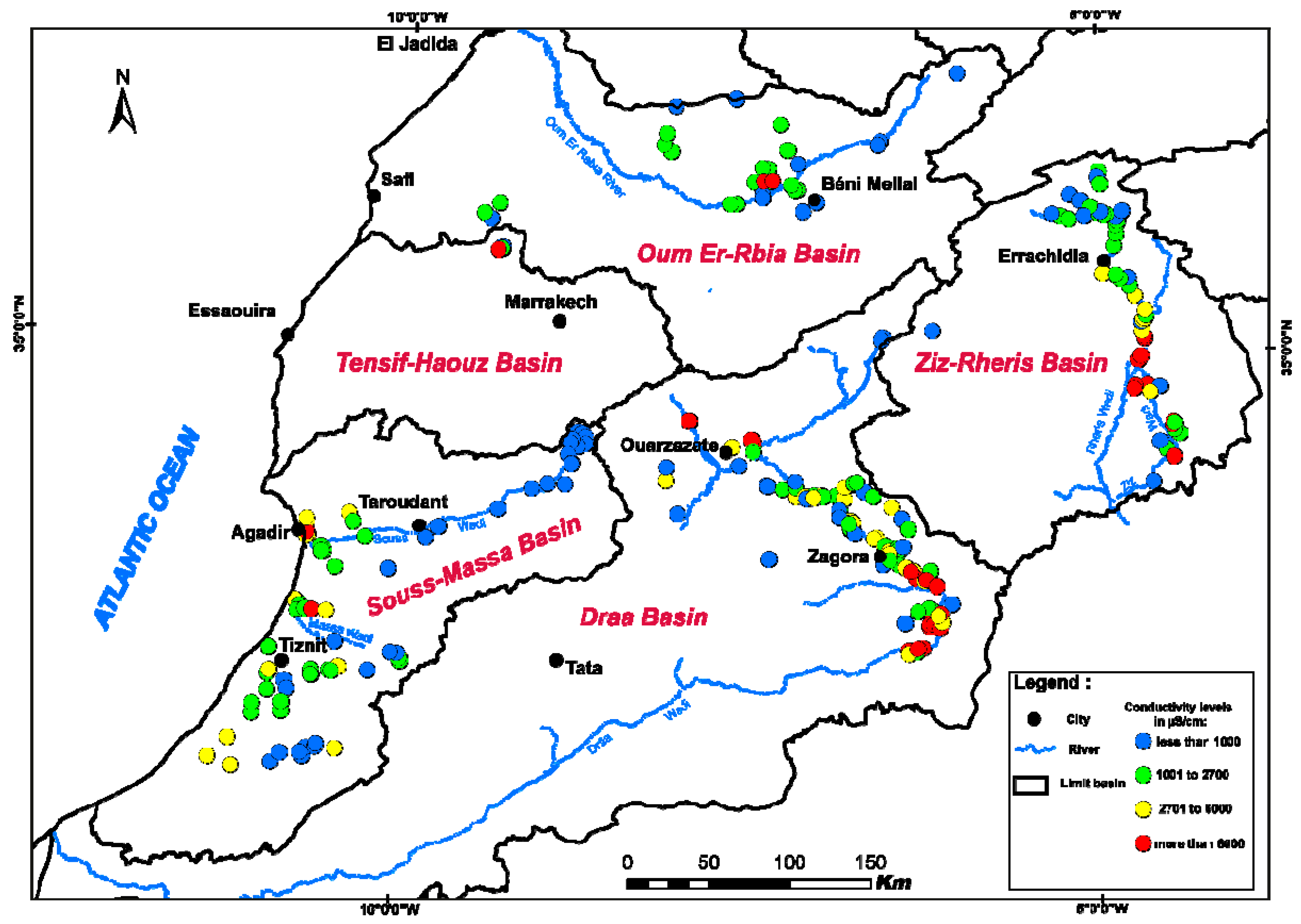
We distinguish two major areas in each basin (Figure 7): (i) upstream, which generally has good water quality and moderate recharge; (ii) downstream (e.g., coastal and agricultural areas) that had poor water quality as a result of high salinity from various sources and a long groundwater residence time. Continued water over-utilization in coastal and irrigated areas will further increase groundwater quality degradation.
The problem of salinity in coastal groundwater from seawater intrusion is acute, especially for the aquifers of Nekkor, Kert, Ghareb, coastal Chaouia, Mnasra and the coastal aquifers of Souss and Massa. Salinity exceeds the permitted threshold in many areas (e.g., Tafilalt, Drâa and Sahara) where the recharge area contains evaporitic deposits (e.g., halite and gypsum).
Generally, aquifers that are significantly affected by nitrate pollution include Tadla, Berrechid, Triffa, Doukkala, R’mel, Tafilalet and Massa. The aquifers of Martil, Gharb, Chtouka, Guercif, Charf El Akab, Beni Mathar, Laou, Souss, Kert, Tafilalet and Haouz have less nitrate pollution overall, but have localized pollution and natural degradation from evaporites. The level of nitrogen in some aquifers, including Beni Moussa (Tadla), Mnasra (Gharb) and Chtouka (Souss-Massa), exceeds the maximum allowed limit of 50 mg/L.
To clarify groundwater quality in all basins, additional characterization is necessary (heavy metals, contamination from liquid and solid wastes). Adequate management strategies to protect groundwater from contamination and over-exploitation are of paramount importance, especially in arid-prone regions, where groundwater often represents the main freshwater resource to sustain human needs.
3.4. Water Availability Predictions
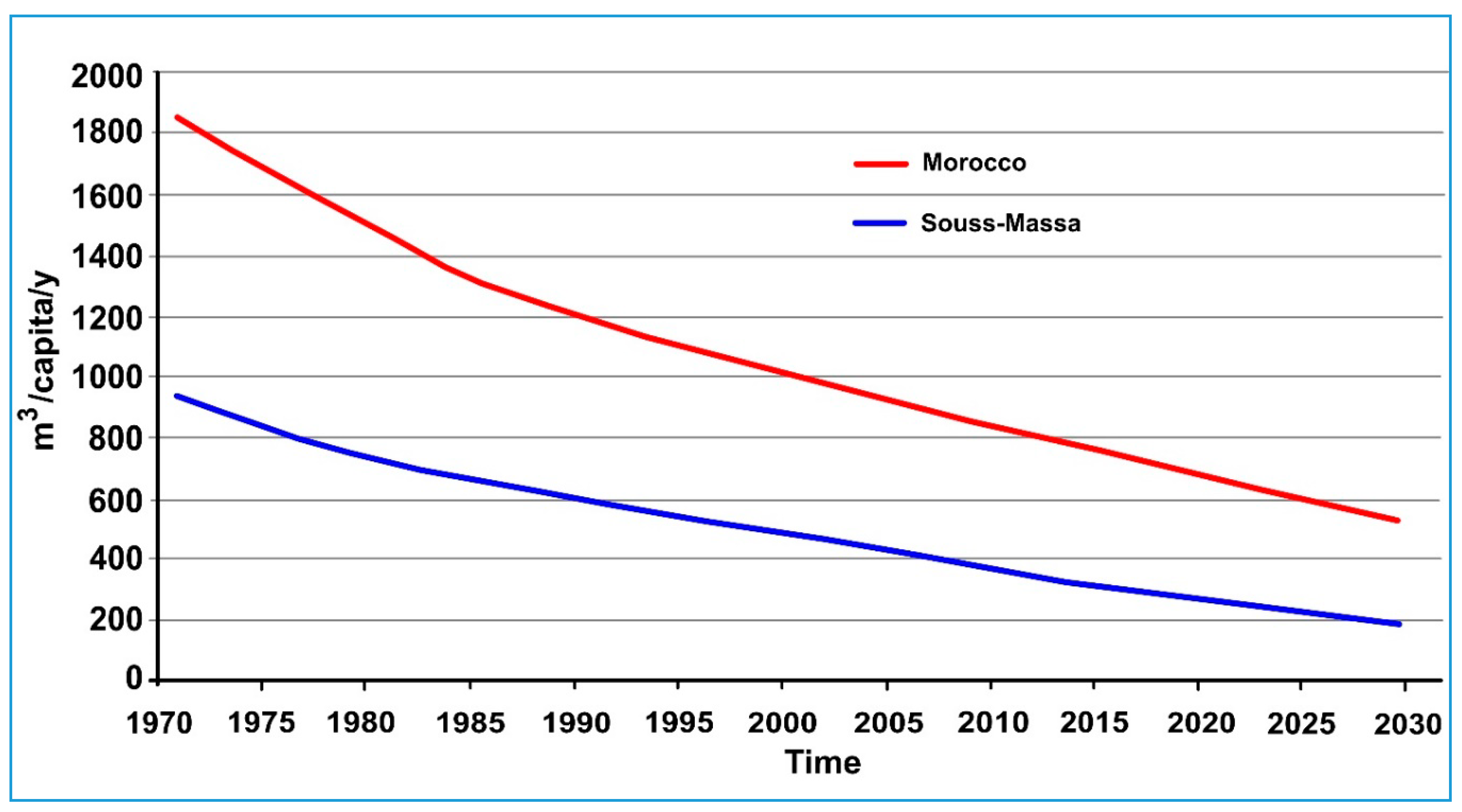
In Morocco, water resources are under increasing pressure because of a growing population, economic development and precipitation decline caused by climate change. Under these circumstances, water availability has dropped from 2000 m3/person/year in 1970 to 1000 m3/person/year in 2000; forecasts predict it will further drop to 500 m³/capita/year by 2030 (Figure 8), approaching the United Nations absolute water scarcity level (500 m³/capita/year).
The average annual rainfall is 346 mm/year through the country, with an estimated internal renewable resource of about 22 BCM/year. Morocco has 135 dams with a total storage capacity of more than 17.5 BCM and a regulatory capacity of about 8.3 BCM/year.
The percentage of renewable water resources withdrawn in the country is almost 50%, with a total surface and groundwater withdrawal of about 12 BCM/year. Agriculture accounts for 87.3% of total water withdrawals. Most agricultural water demand is met by dam infrastructures (85%).
Water demand exceeds water supply in Morocco by 3 BCM (Table 2). Water supply is estimated at 12.90 BCM, while water demand is 19.90 BCM.
3.5. Water Management: Strategy
3.5.1. National Water Strategy
Because climate change may significantly affect the availability of water resources, in 2009 Morocco launched its National Water Strategy (SNE) and National Water Plan (PNE), which focus on complementary water management actions to address water problems and achieve coordinated management of supply and demand, while ensuring an equitable distribution between rural and urban areas [54]. Policy targets include: (1) construction of large and small dams (Three large dams per annum); (2) water resource transfer from the northern areas to the south (800 MCM/year); (3) use of non-conventional water resources, such as the desalination of seawater (510 MCM/year) and brackish water, and the reuse of treated wastewater (325 MCM/year); (4) incentives for water saving in agriculture through conversion of localized irrigation systems to drip irrigation (920,000 ha in 2030), drinking water, tourism, and industry through an improved pipe network that could yield water savings of up to 80% on average in 2020; (5) preservation of groundwater resources through artificial recharge, and setting limits on how much groundwater can be pumped; (6) protecting dams from loss through structural erosion via upstream renovation; (7) protecting against extreme events, particularly floods and droughts; (8) substitution of overexploited groundwater with surface water; and (9) reforestation of 200,000 ha by 2020.
3.5.2. Water Laws
Law of Water 10–95 in 1995 was a major breakthrough in Moroccan water policy. The law’s main objectives were: i) to rationalize water use by development of national and river basin plans, which are in accordance with the National Water Strategy; ii) to provide universal access to the resource; iii) to reduce disparities between cities and villages and ensure water security across the country.
The law’s other stated principles include: (1) water as a limited resource for the public good; (2) regulation of the development, distribution and sale of potable water; (3) improved agricultural water development and use; (4) prevention of illegal water resource development or conduct that causes water pollution.
With regards to PNE implementation, the body of relevant legislation and regulations continues to be strengthened, notably with the adoption in August 2016 of a new Water Act (No. 36–15) that pursues the objectives of Law 10–95, with a view to guaranteeing the right to water access, developing a legal framework for desalination of seawater, and decentralization of water institutions (Table 3). Thus, this new law introduced reforms aimed primarily at consolidating and strengthening decentralized, integrated and participatory management and planning of water resources, strengthening consultation and coordination amongst organizations through the establishment of river basin councils. It also established legal foundations to diversify supply through the use of unconventional water resources, including desalinated seawater, implement water-related information systems, strengthen institutional frameworks and mechanisms for the protection and conservation of water resources (e.g., participatory aquifer management contracts), and strengthen financial instruments for the development of the water sector based on the principle of user pays/polluter pays.
3.6. Sustainable Groundwater Management
Globally, research into groundwater management has contributed much to overall water resource management policies, but there is still a lack the socio-professional context necessary to exploit research findings [55]. In addition, water managers may overlook scientific information that could be useful for decision makers, and may not understand the constraints faced by scientists to undertake and solve water issues [55,56,57,58]. Overcoming some of these coordination issues can improve both the applicability of scientific results and the quality of water management decisions.
In developing countries like Morocco, coordination between socio-professional and academic institutions is still poor. Groundwater managers use selected scientific findings, such as sediment transmissivity and permeability, quantity of water in storage, pumping water levels and water quality/degradation sources. Climate change models and observations can be used by managers to predict effects on groundwater availability. Changes in temperature and precipitation may have a stronger effect on the demand side of the equation than on the supply side [55]. The use of new tools within multidisciplinary approaches becomes highly desirable. Among the integrated management challenges, new types of management instruments, partnerships and institutional changes are needed to improve the efficiency of the water management system in the context of increasing pressure on limited water supplies: (1) economic based instruments: re-allocation through intersectoral and intra-sectoral water quotas and allocations, land use and cropping pattern changes, water tariffs and water markets. As applied for domestic water, Morocco should apply a progressive charge for agricultural water using price bands while taking into account the market price. The tariff lever and the rigorous management of water metering will contribute to stabilizing demand for irrigation water in several extensive irrigated area (e.g., Souss-Massa, Tadla, Saïss, Haouz, etc.); (2) socio-economic instruments: establishment of water users’ associations to improve water management and measures relating to population; and (3) institutional changes: measures required in support of the implementation of those above (e.g., legislation, regulation, improved extension services and institutional changes).
4. Global Changes and Groundwater at Regional Level
The intensification of water stress during the recent decades and the critical condition of many aquifers, particularly the southern part of the country, has prompted the investigation of certain basins with a view to applying integrated management of water resources.
The Souss-Massa and Drâa basins, situated between the Atlantic Ocean, the High Atlas and the Sahara, three factors determine the semi-arid to arid climate of the region: topography, ocean coast and the Sahara. Thus, the northern region, dominated by the High Atlas Mountains, is characterized by a semi-arid to humid climate. The plains (Souss-Massa and Drâa) experience an arid climate. Finally, the southern and southeastern parts of the region are dominated by Saharan climate. The precipitations varies considerably in space and time with a rainfall average of 200 mm/year [12]. The region is surrounded by three rivers, the Souss, Massa and Drâa Wadis, giving the region the informal name “Souss-Massa-Drâa Region”. The Souss and Drâa rivers receive inflow from the High Atlas and Anti Atlas mountains while the Massa River receives influx from the Anti Atlas Mountains [10,19]. The hydrological regime is characterized by strong seasonal and interannual irregularity [20,59]. In these basins, surface water is nearly absent and groundwater constitutes the main source of water for various uses (i.e., domestic, irrigation) with a recourse to retained water from dams.
In the Souss-Massa basin, the Plio-Quaternary shallow aquifer and Turonian deep aquifer constitute the major groundwater resource (Figure 9). Despite interest in the deep aquifers, the shallow aquifer is considered the most important hydrogeological unit in the Souss-Massa Valley because it is the easiest to use and it contains most of the groundwater resources of the basin.
In the Drâa basin, which is divided into six oases, groundwater is present in local alluvial aquifers in each oasis (Figure 10). These alluvial aquifers are hydraulically connected, forming an aquifer cascade, where the underflow can pass across barriers through a relatively small flow section within the alluvial deposits and fractures of an adjacent highly weathered zone [20].
Several constraints, such as aridity (quasi-absence of surface water), limited groundwater potential, high vulnerability to pollution, high water demand, vulnerability of the coastal aquifer to seawater intrusion and significant increase in the irrigated land from groundwater, affect groundwater sustainability and management within the Souss-Massa and Drâa areas.
4.1. Souss-Massa Basin
The Souss-Massa area is the most developed agricultural sector in Morocco and plays a key role in the socioeconomic development of the country. However, this development has been accompanied by a significant decrease in groundwater reserves [7,18,46]. Increased demand for irrigation water and decline in renewable groundwater resources, aggravated by climate change and agricultural production growth, led to water table lowering, degradation on groundwater quality, and high pumping costs. These are currently the major constraints of the management of groundwater resources, which are the main water source to satisfy demand. This situation calls for an urgent intervention by water managers and all other stakeholders to produce solutions as well as identify an alternative water resource.
Some of the Moroccan water strategies have already been implemented in the Souss-Massa region, such as irrigation efficiency improvements through conversion to drip irrigation (more than 90% of farmers are using drip irrigation), and the construction of seawater desalination units for irrigation and drinking water supplies.
4.1.1. Climate Trends
Climate observations made over the past decades indicate that the regions previously classified as humid or sub-humid have regressed to semi-arid and arid [10,12,13,60,61,62,63,64,65]. The climate projections in Morocco predict an increase in average summer temperatures of 2 to 4 °C and a 20% decline in average rainfall by the end of the century [23,63,66,67,68,69,70]. These climate projections suggest gradually increasing aridity due to reduced rainfall and increased temperatures.
The snow cover in the Atlas Mountains, considered a “water tower” for downstream population and agricultural plains, is affected by strong annual and inter-annual climate variability [71,72,73]. Generally, increased temperatures will shorten the amount of time snow is on the ground in the Atlas Mountains and have already led to earlier snow melts [25,73]. Most of the climate models in the UN Intergovernmental Panel on Climate Change [66,67,74] predicts a significant decrease in precipitation in the northern and central parts of Morocco over the next few decades.
In the Souss-Massa basin, the analysis of long-term (1933–2015) precipitation data from four main hydrometeorological stations (Agadir in the downstream area, Taroudant in the middle, Aoulouz in the upstream area and Tiznit in the south) indicates a clear irregularity with time and an increase in annual precipitation from 1933 to 2015. There was a maximum in 1963, followed by a baseline decrease since 1973 (Figure 11a). Furthermore, spatial rainfall patterns showed a clear decrease from upstream to downstream with a difference of up of 100 mm.
The moving average for all investigated stations indicated a regional slope of trendline of about 30 mm for middle and downstream stations (Taroudant, Agadir and Tiznit). A highly significant trend was observed in the upstream area (Aoulouz) with a decreasing trendline of about 100 mm (Figure 11b). This decrease in the precipitation, as a consequence of climate change, can reduce water availability and aquifer recharge. Effects from a changing climate coupled with an increase in water exploitation are expected to exacerbate the already existing water crisis [23,75].
4.1.2. Effects of Global Change on Groundwater
In the Souss-Massa basin, long drought periods considerably affect the availability of groundwater resources as well as their quality. In this area, overexploitation leads to a depletion of water resources and quality degradation for both human consumption and agricultural activities [8]. Developing agricultural activities play an important role in the socioeconomic growth on both regional and national scales. However, this situation has increased the water demand for irrigation, which produce a significant depletion of groundwater reserves [6,76].
According to Seif-Ennasr et al. [69], temperatures are expected to increase up to 2 °C during 2030–2049 and up to 4 °C during 2090–2100 under on model scenario (RCP8.5) compared to the baseline (1986–2005). Precipitation will also decrease, especially in high altitude areas, and the extreme change under RCP8.5 will result in −53% precipitation the end of the 21st century. Clearly, these changes are expected to have several impacts, especially on agricultural demand, dam storage and renewable groundwater. Consequently, the water balance will be in disequilibrium (Figure 12).
As a response to increases in temperature and evapotranspiration, agricultural water demand will also increase. This phenomenon could be accompanied by a significant depletion of groundwater reserves caused by several stressors, including uncontrolled overexploitation of aquifers [10,18].
The impact of climate change and anthropogenic activities has degraded the water quality in the Souss-Massa aquifer. Different chemical and isotopic studies carried out in the area [5,46,47,48,51] indicate that salinity and nitrate contamination of groundwater originates from multiple sources. In the coastal aquifer, overpumping and low recharge led to seawater intrusion [48], whereas in the Chtouka plain, the extensive use of fertilizers and poorly maintained septic tanks in rural areas increased the nitrate concentration in the shallow water table [5,47,51].
The Souss-Massa basin will continue to face water scarcity challenges, that will be aggravated by climate change. Among other consequences, climate change will intensify and complicate the water cycle. It will alter water availability, quality, and demand [77,78]. Thus, an improvement in resiliency and adaptive capacity is needed [14,79].
4.1.3. Integrated Groundwater Management
Contract Approach
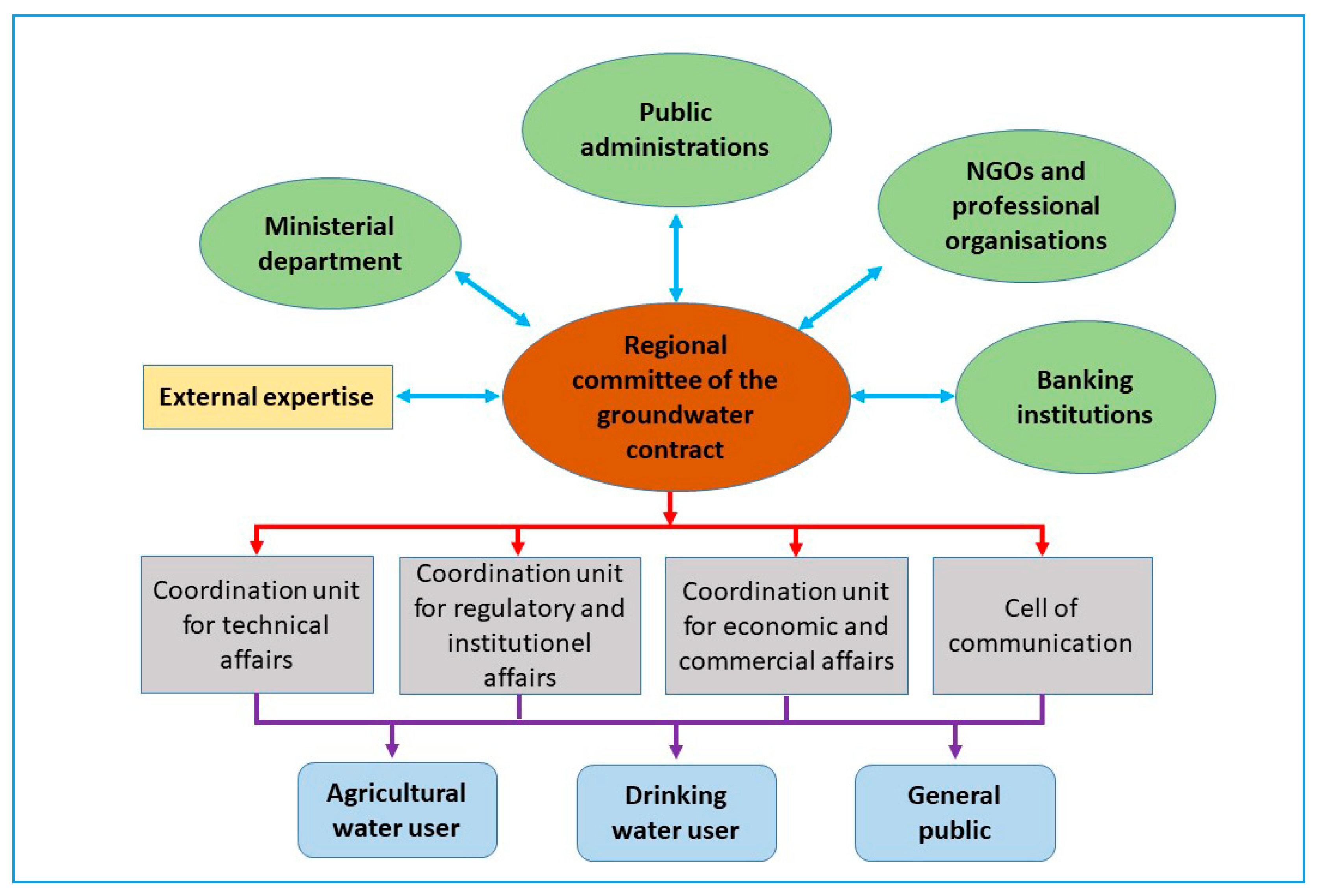
The Souss-Massa River Basin Agency developed a groundwater management action plan and incorporated the main provisions of the action plan into a framework signed by key regional stakeholders in the water sector (Figure 13). This convention specifies the responsibilities of stakeholders and their financial contribution to funding the action plan. These measures have been discussed and agreed upon by the agency and the key regional stakeholders: (1) approval of simplified procedures for delivering well/borehole drilling permits and extraction licenses; (2) organization of the drilling profession; (3) water conservation measures; (4) restrictions on new irrigation development; and (5) awareness building and communication.
These measures limit new entrants and provide incentives to current users to sign contracts in order to be formally recognized as users and become eligible for support for water conservation measures.
Change in Irrigation Technology
In Morocco, the change in irrigation technology (switch to drip irrigation) started in the Souss-Massa basin before the launch of the subsidized Green Morocco Plan by the government in 2008. This project is a major national strategy as it aims to sustain the development of Moroccan agriculture by: (1) a national irrigation water conservation program; (2) develop public-private partnerships in irrigation; (3) prepare the first seawater desalination project for irrigation; (4) use environmentally friendly mechanisms and support climate change adaptations; and (5) encourage the use of micro-irrigation through subsidies from the Agricultural Development Fund.
Souss-Massa aquifer water irrigates crops for high-value export markets and it is one of the most overexploited aquifers in the country [18,80]. Thus, the actions proposed in this area, especially by the Hydraulic Basin Agency, to enforce groundwater provisions, such as control of drilling activities or groundwater extraction, and groundwater permit requirements are difficult to implement because of the lack of sustained support from elected councils, local authorities, non-governmental organizations and smallholders. In the irrigated areas, the most easily accepted action to save groundwater is the conversion to drip irrigation systems, which often benefits the farmers by increasing yield and decreasing pumping costs. As reported by Bouchaou et al. [7], the crop and economic water productivity are lower in field that irrigated by gravity system in comparison with drip irrigation (e.g., for field tomato crop and economic water productivity were increased by 2 and 10 times respectively). This shift to drip irrigation allows the economization of around 30% of water resources in the area. But, since the shifting to this irrigation technology, we notice that the farmers extend their cultivated area to more increase their crop production. In addition, using solar energy reduce pumping cost but increase uncontrolled groundwater extraction. For this reason, water balance at catchment scale is often imbalanced due to the additional water pumping to cover the new irrigated area. To mitigate this constraint, the local policies signed an agreement with farmers consisting to pay 50% of the cost price (estimated to 1.5 USD/cubic meter) of desalinated water. This agreement is part of win-win process and concerns especially big farmers who targeted mainly export market. This policy is applied also for water supply from dams.
Artificial Recharge
The artificial recharge of aquifers is an important action carried out by the Souss-Massa Hydraulic Agency. The aim is to strengthen a portion of the natural recharge, mitigate continuing declines in water level (Sebt el Guerdane and Oulad Teima areas) and/or to slow progressive sea intrusion (Agadir coastal aquifer). It also dilutes saline water, which results in more mineralized water in the middle and downstream parts of a watershed (Issen area).
The first artificial recharge of groundwater was in 1991, which has an average release volume from the Aoulouz and Imi El Kheng dams of 64 MCM/year [52]. The artificial recharge scheme in the Souss area uses direct recharge techniques that typically employ retention dykes (3–4 m high) in the Souss and Talkjount riverbeds to enhance the natural percolation of water into the subsurface [52].
Approximately 85% of water release infiltrates in the upstream part of the basin while only 15% reached the downstream part (Figure 14). The infiltration volume in the Souss riverbed after dam releases are controlled by the lithology and tectonic structures [57]. Therefore, artificial recharge could significantly help prevent further deterioration of water resources, both quantitatively and qualitatively.
Alternative Groundwater Resources
To carry out water resources safeguarding, multiple action plans have been established. Since 2006, the irrigation district of El Guerdane is supplied from the Aoulouz dam and managed by a private operator with the aim of irrigating 10,000 ha of citrus. This project constitutes one of the successful partnerships between public-private sectors and farmers. Additionally, a desalination plant for irrigation and domestic purposes will be built in the Chtouka zone to supply water for greenhouses growers (9000 ha at the beginning of the project run and 12,500 ha by 2035) and drinking water for Grand Agadir. Its objective is to meet an annual need of about 60 MCM of desalinated water at a rate of 1 MCM/day in the beginning of the project (end of 2020) and 1.5 MCM/day by 2035 [76,81]. This desalination plant will allow the region to compensate for a deficit of 60 MCM [1]. Finally, around 50 MCM/year of treated wastewater is provided for multiple uses and can offset negative impacts of water scarcity. This alternative resource could be used for agriculture and the watering of green areas, artificial recharge, forest irrigation and artificial wetlands. With these new alternatives of groundwater resources, the Souss-Massa region will be more effectively managed and the problems associated with water scarcity, climate change and salinization will be mitigated.
4.2. Drâa Basin
The Drâa basin experiences an arid to Saharan climate, and hosts some of the most important oases in southeastern Morocco. The local population is especially concentrated near the oases and the economy is based almost entirely on local and traditional agricultural production [19]. Sustainable livelihoods have been challenged by frequent droughts in recent years [19,20,82,83].
A subtropical dry climate with a warm temperate desert scrub zone and bimodal precipitation distribution characterizes this area. Cold northern winds dominate in winter, while dry easterly winds prevail in summer. The incoming Atlantic cloud front and elevation are responsible for decreasing precipitation from west to east and from north to south, respectively. Most precipitation occurs during the autumn and spring with erratic events. The annual precipitation mean is 112 mm, except for mountain stations (e.g., Agouim and M’semrir), but showed a decreasing trend over 1933–2015 (M’semrir station) and 1965–2015 (other stations; Figure 15a). Elevation controls the precipitation latitudinally with maxima of 682 mm in 1970 for Aguim station and 784 mm in 2014 for M’semrir station and a minimum of 15 mm in 2010 for Bge El Mansour Eddahbi (plain between the Atlas Mountains).
Figure 15a shows that precipitation has a high variability at and among the stations, which coincides with periods of drier and humid conditions lasting 3–5 years. More humid periods were identified in the late 1940s to the mid-1950s, the mid-1960s and the late 1980s. Periods of drought occurred in the early 1970s, early 1980s and the late 1990s through to the beginning of the new millennium. The late 1940s to late 1960s were generally wetter than the period before and the last 30 years.
It can be concluded from this analysis that there is no or negligible regional trend in precipitation (Figure 15b), but there is decadal variability with drier and more humid periods (Figure 15a). According to Schultz et al. [84], climate change is predicted to reduce mean annual precipitation but increase individual rainfall events, leading to a higher number of floods.
The availability and quality of surface water from dams and groundwater determines the sustainability of the six oases in the Drâa basin. Their alluvial aquifers are pumped to satisfy irrigation demand, and these aquifers are mainly recharged by El Mansour Eddahbi dam water releases (Figure 10).
Several authors have highlighted the decline in groundwater levels in the northern part of the basin near Ouarzazate, and the rise of salinity from the El Mansour Eddahbi dam to the south through the succession of oases [19,20,85,86]. The major agricultural production in the basin is palm trees, which have relatively high tolerance for salinity. Nonetheless, the combined effects of high evaporation rates and insufficient water flushing through the root zone have aggravated the problem of salinization.
In the last decade, agricultural areas for watermelon farming have increased due to the subvention of the Green Morocco Plan, of which 80% of the fees of agricultural exploitation can be subsidized [82,83]. These practices require large quantities of water, thereby exacerbating water scarcity in the Drâa basin and, consequently, overexploiting groundwater. The first main driving force of groundwater depletion in these oases is high evaporation and low and variable rainfall. Furthermore, socioeconomic factors accelerate the degradation of the oases ecosystem [20].
In conclusion, recurring droughts, overexploitation and salinity of groundwater as well as demographic growth constitute the principal problems for groundwater management in the oasis area of Drâa basin. Johansen et al [87], suggested that the only solution to guarantee sustainable water use is a drastic reduction of irrigated agricultural area.
5. Conclusions and Recommendations
The majority of hydrological basins in Morocco suffer from overexploitation and degradation of water resources that is further aggravated by climate change and anthropogenic activity. The future of the region relies on rational planning and integrated management based on water saving and quality protections to make the best use of the available water resources. For sustainable development in the region and to attenuate the impact of global climate change, we recommend a new strategy based on four main elements: (1) continuation and acceleration of non-conventional water use; (2) increase and maintenance of the existing hydraulic infrastructure; (3) economy of water in all sectors that consume large amounts; and (4) reinforcement and application of the lawful framework. The intensification of water stress over recent decades and the critical condition of many aquifers, particularly in the southern part of the country, has prompted the investigation of certain basins with a view to applying integrated management of water resources.
It is necessary to update integrated water resource management plans, through the use of groundwater models, and reduce vulnerability to water-related risks as well as adapt to climate change and increasing anthropogenic pressure. It is also important to identify and carry out a technical, economic and environmental assessment of the possibilities for water resource development, as well as propose actions to protect these resources and develop non-conventional water resources.
In the Souss-Massa basin, some management solutions (e.g., artificial recharge, seawater and brackish water desalination, and treated wastewater reuse) have been adopted to restore the negative groundwater balance or, at least, mitigate the recorded deficits, as well as slow down the progress of saline intrusion in coastal areas. These plans aim to save water for future generations and increase crop production.
In the hyper-arid southern oasis region, there is a serious scarcity of water resources, so water and agricultural policies must focus subsidies on sustainable agricultural activities that suit hyper-arid climates and socioeconomic constraints, such as aromatic and medicinal plants. The restoration of palm date heritage and the planting of new species with high-market value can be an alternative to supplying high quantities of water to certain agricultural types. Understanding desert oases dynamics will help to support biodiversity and identify the dispersal pathways that will serve as a baseline for future management policies in ecosystems that depend on uncertain climatic events.
Finally, through this groundwater synthesis, we recommend the use of a balanced management system that considers scientific, technical, economic, institutional and social measures appropriate to the hydrogeological setting and socioeconomic situation of each aquifer system that can be introduced with the agreement of stakeholders to promote more sustainable groundwater use.
Author Contributions
Conceptualization, M.H. and L.B.; methodology, L.B and M.H.; software, M.H.; resources, L.B.; data curation, L.B.; writing—original draft preparation, M.H. L.B.; writing—review and editing, I.B., A.C. and A.S.; project administration, L.B. All authors have read and agreed to the published version of the manuscript.
Funding
This research received no external funding
Acknowledgments
The authors express their gratitude to Hydraulic Department of Rabat and Hydraulic Basin Agency of Souss-Massa for access to their database. This work was carried out within the CHARISMA Project with the assistance of the Hassan 2 Academy of Sciences and techniques, the support of Ibn Zohr University and WASA project. The groundwater quality results were obtained during the NATO Project (ESP.MD.SFPP 983,134) ‘‘Investigating salinity and radioactivity in water resources in Morocco’’. We thank three reviewers and the editor for their constructive remarks that significantly improved the quality of this paper. Finally, we thank Kara Bogus for English editing of a manuscript draft.
Conflicts of Interest
The authors declare no conflicts of interest.
References
- Gleeson, T.; VanderSteen, J.; Sophocleous, M.A.; Taniguchi, M.; Alley, W.M.; Allen, D.M.; Zhou, Y. Groundwater Sustainability Strategies. Nat. Geosci. 2010, 3, 378–379. [Google Scholar] [CrossRef]
- Wada, Y.; Van Beek, L.P.H.; Van Kempen, C.M.; Reckman, J.W.T.M.; Vasak, S.; Bierkens, M.F.P. Global Depletion of Groundwater Resources. Geophys. Res. Lett. 2010, 37, 1–5. [Google Scholar] [CrossRef] [Green Version]
- Gleeson, T.; Befus, K.M.; Jasechko, S.; Luijendijk, E.; Cardenas, M.B. The Global Volume and Distribution of Modern Groundwater. Nat. Geosci. 2016, 9, 161–167. [Google Scholar] [CrossRef]
- Schilling, J.; Freier, K.P.; Hertig, E.; Scheffran, J. Climate Change, Vulnerability and Adaptation in North Africa with Focus on Morocco. Agric. Ecosyst. Environ. 2012, 156, 12–26. [Google Scholar] [CrossRef]
- Malki, M.; Choukr Allah, R.; Bouchaou, L.; Ait Brahim, Y.; Hirich, A.; Reichert, B. Evolution of Groundwater Quality in Intensive Agricultural Zone: Case of Chtouka-Massa Aquifer, Morocco. Arab. J. Geosci. 2016, 9. [Google Scholar] [CrossRef]
- Seif-Ennasr, M.; Hirich, A.; El Morjani, Z.E.A.; Choukr-Allah, R.; Zaaboul, R.; Nrhira, A.; Malki, M.; Bouchaou, L.; Beraaouz, E.H. Assessment of Global Change Impacts on Groundwater Resources in Souss-Massa Basin. In Water Resources in Arid Areas: The Way Forward; Springer: Berlin/Heidelberg, Germany, 2017; pp. 115–140. [Google Scholar] [CrossRef]
- Bouchaou, L.; Choukr-Allah, R.; Hirich, A.; Seif-Ennasr, M.; Malki, M.; Abahous, H.; Bouaakaz, B.; Nghira, A. Climate Change and Water Valuation in Souss-Massa Region: Management and Adaptive Measures. Eur. Water 2017, 60, 203–209. [Google Scholar]
- Malki, M.; Choukr-Allah, R.; Bouchaou, L.; Hirich, A.; Ait Brahim, Y.; Krimissa, S.; Hssaisoune, M.; Nghira, A.; Barceló, D. Assessment of Groundwater Quality: Impact of Natural and Anthropogenic Contamination in Souss-Massa River Basin. In The Souss-Massa River Basin, Morocco; Springer: Cham, Switzerland, 2017; Volume 53. [Google Scholar] [CrossRef]
- Direction de la Recherche et de la Planification de l’Eau (DRPE). Eaux Souterraines Au Maroc Comment Concilier Satisfaction Des Besoins et Développement Durable Des Ressources En Eau Souterraines; Ministère délégué auprès du Ministre de l’Energie, des Mines, de l’Eau et de l’Environnement Chargé de l’Eau: Rabat, Morocco, 2014; pp. 1–53, Unpublished Report.
- Bouchaou, L.; Tagma, T.; Boutaleb, S.; Hssaisoune, M.; El Morjani, Z.E.A. Climate Change and Its Impacts on Groundwater Resources in Morocco: The Case of the Souss- Massa Basin. Clim. Chang. Eff. Groundw. Resour. A Glob. Synth. Find. Recomm. 2011, 2007, 129–144. [Google Scholar]
- Ait Kadi, M.; Ziyad, A. Integrated Water Resources Management in Morocco. In Global Water Security; Springer: Singapore, 2018; pp. 143–163. [Google Scholar] [CrossRef]
- Abahous, H.; Ronchail, J.; Sifeddine, A.; Kenny, L.; Bouchaou, L. Trend and Change Point Analyses of Annual Precipitation in the Souss-Massa Region in Morocco during 1932–2010. Theor. Appl. Climatol. 2018, 134, 1153–1163. [Google Scholar] [CrossRef]
- Ait Brahim, Y.; Saidi, M.E.M.; Kouraiss, K.; Sifeddine, A.; Bouchaou, L. Analysis of Observed Climate Trends and High Resolution Scenarios for the 21st Century in Morocco. J. Mater. Environ. Sci. 2017, 8, 1375–1384. [Google Scholar]
- Seif-Ennasr, M.; Zaaboul, R.; Hirich, A.; Caroletti, G.N.; Bouchaou, L.; El Morjani, Z.E.A.; Beraaouz, E.H.; McDonnell, R.A.; Choukr-Allah, R. Climate Change and Adaptive Water Management Measures in Chtouka Aït Baha Region (Morocco). Sci. Total Environ. 2016, 573, 862–875. [Google Scholar] [CrossRef]
- Dihazi, A.; Jaiti, F.; WafaTaktak; kilani-Feki, O.; Jaoua, S.; Driouich, A.; Baaziz, M.; Daayf, F.; Serghini, M.A. Use of Two Bacteria for Biological Control of Bayoud Disease Caused by Fusarium Oxysporum in Date Palm (Phoenix Dactylifera L) Seedlings. Plant Physiol. Biochem. 2012, 55, 7–15. [Google Scholar] [CrossRef] [PubMed]
- Zhao, X.; Dupont, L.; Cheddadi, R.; Kölling, M.; Reddad, H.; Groeneveld, J.; Ain-Lhout, F.Z.; Bouimetarhan, I. Recent Climatic and Anthropogenic Impacts on Endemic Species in Southwestern Morocco. Quat. Sci. Rev. 2019, 221, 105889. [Google Scholar] [CrossRef]
- M’Bark, A.; Bouchaou, L. Les Problèmes Majeurs de La Gestion de l’eau Au Maroc. Sécheresse (Montrouge) 2004, 15, 187–194. [Google Scholar]
- Hssaisoune, M.; Bouchaou, L.; N’da, B.; Malki, M.; Abahous, H.; Fryar, A.E. Isotopes to Assess Sustainability of Overexploited Groundwater in the Souss–Massa System (Morocco). Isot. Environ. Health Stud. 2017, 53, 298–312. [Google Scholar] [CrossRef] [PubMed]
- Warner, N.; Lgourna, Z.; Bouchaou, L.; Boutaleb, S.; Tagma, T.; Hsaissoune, M.; Vengosh, A. Integration of Geochemical and Isotopic Tracers for Elucidating Water Sources and Salinization of Shallow Aquifers in the Sub-Saharan Drâa Basin, Morocco. Appl. Geochem. 2013, 34, 140–151. [Google Scholar] [CrossRef]
- Klose, S.; Reichert, B.; Lahmouri, A. Management Options for a Sustainable Groundwater Use in the Middle Drâa Oases under the Pressure of Climatic Changes. Clim. Chang. Water Resour. Middle East N. Afr. 2008, 179–195. [Google Scholar] [CrossRef]
- FAO. Water Management in Fragile Systems; FAO: Roma, Italy, 2018. [Google Scholar]
- Closas, A.; Villholth, K.G. Aquifer Contracts: A Means to Solving Groundwater Over-Exploitation in Morocco; International Water Management Institute (IWMI): Colombo, Sri Lanka, 2016; Volume 20, 20p., (Groundwater Solutions Initiative for Policy and Practice (GRIPP) Case Profile Series 01). [Google Scholar] [CrossRef]
- Aoubouazza, M.; Rajel, R. Impact of Extreme Climate Events on Water Resources and Agriculture and Biodiversity in Morocco. J. Climatol. Weather Forecast 2013, 1, 1–8. [Google Scholar] [CrossRef] [Green Version]
- N’da, A.B.; Bouchaou, L.; Reichert, B.; Hanich, L.; Ait Brahim, Y.; Chehbouni, A.; Beraaouz, E.H.; Michelot, J.L. Isotopic Signatures for the Assessment of Snow Water Resources in the Moroccan High Atlas Mountains: Contribution to Surface and Groundwater Recharge. Environ. Earth Sci. 2016, 75. [Google Scholar] [CrossRef]
- Boudhar, A.; Boulet, G.; Hanich, L.; Sicart, J.E.; Chehbouni, A. Energy Fluxes and Melt Rate of a Seasonal Snow Cover in the Moroccan High Atlas. Hydrol. Sci. J. 2016, 61, 931–943. [Google Scholar] [CrossRef]
- Schulz, O.; de Jong, C. Snowmelt and Sublimation: Field Experiments and Modelling in the High Atlas Mountains of Morocco. Hydrol. Earth Syst. Sci. 2004, 8, 1076–1089. [Google Scholar] [CrossRef]
- Re, V.; Sacchi, E.; Martin-Bordes, J.L.; Aureli, A.; El Hamouti, N.; Bouchnan, R.; Zuppi, G.M. Processes Affecting Groundwater Quality in Arid Zones: The Case of the Bou-Areg Coastal Aquifer (North Morocco). Appl. Geochem. 2013, 34, 181–198. [Google Scholar] [CrossRef]
- Fetouani, S.; Sbaa, M.; Vanclooster, M.; Bendra, B. Assessing Ground Water Quality in the Irrigated Plain of Triffa (North-East Morocco). Agric. Water Manag. 2008, 95, 133–142. [Google Scholar] [CrossRef]
- Fekkoul, A.; Zarhloule, Y.; Boughriba, M.; Barkaoui eddine, A.; Jilali, A.; Bouri, S. Impact of Anthropogenic Activities on the Groundwater Resources of the Unconfined Aquifer of Triffa Plain (Eastern Morocco). Arab. J. Geosci. 2013, 6, 4917–4924. [Google Scholar] [CrossRef]
- Boughriba, M.; Correia, A.; Zarhloule, Y.; Rimi, A. Climate Change Impact in a Shallow Coastal Mediterranean Aquifer, at Saïdia, Morocco. In Proceedings of the 20th Salt Water Intrusion Meeting, Naples, FL, USA, 23–27 June 2008; pp. 30–33. [Google Scholar]
- Boughriba, M.; Jilali, A. Climate Change and Modeling of an Unconfined Aquifer: The Triffa Plain, Morocco. Environ. Dev. Sustain. 2017. [Google Scholar] [CrossRef]
- Najib, S.; Fadili, A.; Mehdi, K.; Riss, J.; Makan, A.; Guessir, H. Salinization Process and Coastal Groundwater Quality in Chaouia, Morocco. J. Afr. Earth Sci. 2016, 115, 17–31. [Google Scholar] [CrossRef]
- Mountadar, S.; Younsi, A.; Hayani, A.; Siniti, M.; Tahiri, S. Groundwater Salinization Process in the Coastal Aquifer Sidi Abed-Ouled Ghanem (Province of El Jadida, Morocco). J. Afr. Earth Sci. 2018, 147, 169–177. [Google Scholar] [CrossRef]
- Laftouhi, N.E.; Vanclooster, M.; Jalal, M.; Witam, O.; Aboufirassi, M.; Bahir, M.; Persoons, É. Groundwater Nitrate Pollution in the Essaouira Basin (Morocco). Comptes Rendus Geosci. 2003, 335, 307–317. [Google Scholar] [CrossRef]
- Ouhamdouch, S.; Bahir, M.; Ouazar, D.; Carreira, P.M.; Zouari, K. Evaluation of Climate Change Impact on Groundwater from Semi-Arid Environment (Essaouira Basin, Morocco) Using Integrated Approaches. Environ. Earth Sci. 2019, 78, 1–14. [Google Scholar] [CrossRef]
- Bouchaou, L.; Michelot, J.L.; Qurtobi, M.; Zine, N.; Gaye, C.B.; Aggarwal, P.K.; Marah, H.; Zerouali, A.; Taleb, H.; Vengosh, A. Origin and Residence Time of Groundwater in the Tadla Basin (Morocco) Using Multiple Isotopic and Geochemical Tools. J. Hydrol. 2009, 379, 323–338. [Google Scholar] [CrossRef]
- Kuper, M.; Hammani, A.; Chohin, A.; Garin, P.; Saaf, M. When Groundwater Takes over: Linking 40 Years of Agricultural and Groundwater Dynamics in a Large-Scale Irrigation Scheme in Morocco. Irrig. Drain. 2012, 61 (Suppl. S1), 45–53. [Google Scholar] [CrossRef]
- Barakat, A.; Meddah, R.; Afdali, M.; Touhami, F. Physicochemical and Microbial Assessment of Spring Water Quality for Drinking Supply in Piedmont of Béni-Mellal Atlas (Morocco). Phys. Chem. Earth 2018, 104, 39–46. [Google Scholar] [CrossRef]
- Barakat, A.; Hilali, A.; Baghdadi El, M.; Touhami, F. Assessment of Shallow Groundwater Quality and Its Suitability for Drinking Purpose near the Béni-Mellal Wastewater Treatment Lagoon (Morocco). Hum. Ecol. Risk Assess. 2019, 1–20. [Google Scholar] [CrossRef]
- Barakat, A.; Mouhtarim, G.; Saji, R.; Touhami, F. Health Risk Assessment of Nitrates in the Groundwater of Beni Amir Irrigated Perimeter, Tadla Plain, Morocco. Hum. Ecol. Risk Assess. 2019, 1–15. [Google Scholar] [CrossRef]
- Gamar, A.; Zair, T.; El Kabriti, M.; El Hilali, F. Study of the Impact of the Wild Dump Leachates of the Region of El Hajeb (Morocco) on the Physicochemical Quality of the Adjacent Water Table. Karbala Int. J. Mod. Sci. 2018, 4, 382–392. [Google Scholar] [CrossRef]
- Lgourna, Z.; Warner, N.R.; Lhoussaine, B.; Boutaleb, S.; Hssaisoune, M.; Tagma, T.; Ettayfi, N.; Vengosh, A. Elucidating the Sources and Mechanisms of Groundwater Salinization in the Ziz Basin of Southeastern Morocco. Environ. Earth Sci. 2014, 73. [Google Scholar] [CrossRef]
- Lgourna, Z.; Warner, N.R.; Lhoussaine, B.; Boutaleb, S.; Tagma, T.; Hssaisoune, M.; Ettayfi, N. Nitrate Contamination of Alluvial Groundwater in the Ziz Basin, Southeastern Morocco. Moroc. J. Chem. 2014, 5, 447–451. [Google Scholar]
- Karroum, M.; Elgettafi, M.; Elmandour, A.; Wilske, C.; Himi, M.; Casas, A. Geochemical Processes Controlling Groundwater Quality under Semi Arid Environment: A Case Study in Central Morocco. Sci. Total Environ. 2017, 609, 1140–1151. [Google Scholar] [CrossRef]
- Rochdane, S.; Reddy, D.V.; El Mandour, A. Hydrochemical and Isotopic Characterisation of Eastern Haouz Plain Groundwater, Morocco. Environ. Earth Sci. 2015, 73, 3487–3500. [Google Scholar] [CrossRef]
- Bouchaou, L.; Michelot, J.L.; Vengosh, A.; Hsissou, Y.; Qurtobi, M.; Gaye, C.B.; Bullen, T.D.; Zuppi, G.M. Application of Multiple Isotopic and Geochemical Tracers for Investigation of Recharge, Salinization, and Residence Time of Water in the Souss-Massa Aquifer, Southwest of Morocco. J. Hydrol. 2008, 352, 267–287. [Google Scholar] [CrossRef]
- Tagma, T.; Hsissou, Y.; Bouchaou, L.; Bouragba, L.; Boutaleb, S. Groundwater Nitrate Pollution in Souss-Massa Basin (South-West Morocco) Past and Modern Contamination Studies View Project Geophysical and Structural Analysis of Souss-Massa System View Project Tarik Tagma. Afr. J. Environ. Sci. Technol. 2010, 3, 301–309. [Google Scholar] [CrossRef]
- Vinson, D.S.; Tagma, T.; Bouchaou, L.; Dwyer, G.S.; Warner, N.R.; Vengosh, A. Occurrence and Mobilization of Radium in Fresh to Saline Coastal Groundwater Inferred from Geochemical and Isotopic Tracers (Sr, S, O, H, Ra, Rn). Appl. Geochem. 2013. [Google Scholar] [CrossRef]
- Görlich, I.; Weigand, S.; Beuel, S.; Bouchaou, L.; Reichert, B. Statusanalyse von Meerwasserintrusionen Und Grundwasserhaushaltsmodellierung Des Oberen Küstenaquifers in Agadir, Marokko. Grundwasser 2015. [Google Scholar] [CrossRef]
- Hssaisoune, M.; Bouchaou, L.; Matsumoto, T.; Araguas, L.; Kraml, M.; Aggarwal, P. New Evidences on Groundwater Dynamics from the Souss-Massa System (Morocco): Insights Gained from Dissolved Noble Gases. Appl. Geochem. 2019, 109, 104395. [Google Scholar] [CrossRef]
- Danni, S.O.; Bouchaou, L.; Elmouden, A.; Brahim, Y.A.; N’da, B. Assessment of Water Quality and Nitrate Source in the Massa Catchment (Morocco) Using δ 15N and δ 18O Tracers. Appl. Radiat. Isot. 2019, 154, 108859. [Google Scholar] [CrossRef] [PubMed]
- Agence du Bassin Hydraulique du Souss-Massa (ABHSM). Etude de Révision Du Plan Dircteur d’Aménagement Intégré Des Ressources En Eau (PDAIRE) Du Bassin Du Souss-Massa; Agence du Bassin Hydraulique du Souss-Massa (ABHSM): Agadir, Morocco, 2008; Unpublished report.
- Hellegers, P.; Immerzeel, W.; Droogers, P. Economic Concepts to Address Future Water Supply-Demand Imbalances in Iran, Morocco and Saudi Arabia. J. Hydrol. 2013, 502, 62–67. [Google Scholar] [CrossRef]
- Alaoui, M. Water Sector in Morocco: Situation and Perspectives. J. Water Resour. Ocean Sci. 2013, 2, 108. [Google Scholar] [CrossRef]
- Jacobs, K.; Pulwarty, R. Management’ Science, Planning and Decision-Making. In Water: Science, Policy, and Management Challenges and Opportunities; Lawford, R.G., Fort, D.D., Hartmann, H.C., Eden, S., Eds.; AGU Books Board: Washington, DC, USA, 2003. [Google Scholar]
- Struckmeier, W.; Howard, K.; Chilton, J. The International Association of Hydrogeologists (IAH): Reflecting on 60 Years of Contributions to Groundwater Science and Water Management. Hydrogeol. J. 2016, 1069–1086. [Google Scholar] [CrossRef] [Green Version]
- Hssaisoune, M.; Boutaleb, S.; Benssaou, M.; El Beraaouz, H.; Tagma, T.; El Fasskaoui, M.; Bouchaou, L. Geophysical and Structural Analysis of the Souss-Massa Aquifer: Synthesis and Hydrogeological Implications. Geo. Eco. Trop. 2012, 36, 63–82. [Google Scholar]
- Knouz, N.; Boudhar, A.; Bachaoui, E.M.; Saadi, C. Comparative Approach of Three Popular Intrinsic Vulnerability Methods: Case of the Beni Amir Groundwater (Morocco). Arab. J. Geosci. 2018, 11. [Google Scholar] [CrossRef]
- Hssaisoune, M.; Boutaleb, S.; Benssaou, M.; Bouaakkaz, B.; Bouchaou, L. Physical Geography, Geology, and Water Resource Availability of the Souss-Massa River Basin. In Handbook of Environmental Chemistry; Choukr-Allah, R., Ragab, R., Bouchaou, L., Barceló, D., Eds.; Springer International Publishing: Cham, Switzerland, 2016; Volume 5, pp. 1–12. [Google Scholar] [CrossRef]
- Driouech, F.; Déqué, M.; Sánchez-Gómez, E. Weather Regimes-Moroccan Precipitation Link in a Regional Climate Change Simulation. Glob. Planet. Chang. 2010, 72, 1–10. [Google Scholar] [CrossRef]
- Driouech, F.; Ben Rached, S.; El Hairech, T. Preface. In Climate Change and Food Security in West Asia and North Africa; Sivakumar, M.V.K., Lal, R., Selvaraju, R., Hamdan, I., Eds.; Springer Science+Business Media: Dordrecht, The Netherlands, 2013; pp. vii–viii. [Google Scholar] [CrossRef]
- Ouatiki, H.; Boudhar, A.; Ouhinou, A.; Arioua, A.; Hssaisoune, M.; Bouamri, H.; Benabdelouahab, T. Trend Analysis of Rainfall and Drought over the Oum Er-Rbia River Basin in Morocco during 1970–2010. Arab. J. Geosci. 2019, 12. [Google Scholar] [CrossRef]
- Khomsi, K.; Mahe, G.; Sinan, M.; Snoussi, M. Hydro-Climatic Variability in Two Moroccan Basins: Comparative Analysis of Temperature, Rainfall and Runoff Regimes. IAHS AISH Proc. Rep. 2013, 359, 183–190. [Google Scholar]
- Khomsi, K.; Mahe, G.; Tramblay, Y.; Sinan, M.; Snoussi, M. Trends in Rainfall and Temperature Extremes in Morocco. Nat. Hazards Earth Syst. Sci. Discuss. 2015, 3, 1175–1201. [Google Scholar] [CrossRef] [Green Version]
- Strohmeier, S.; López, P.L.; Haddad, M.; Nangia, V.; Veldkamp, T.; Sterk, G. Surface Runoff and Drought Assessment Using Global Water Resources Datasets - from Oum Er Rbia Basin to the Moroccan Country Scale. Water Resour. Manag. 2019. [Google Scholar] [CrossRef]
- IPCC. The Physical Science Basis. Contribution of Working Group I to the Fourth Assessment Report of the Intergovernmental Panel on Climate Change; Cambridge University Press: Cambridge, UK; New York, NY, USA, 2007; pp. 1–43. [Google Scholar]
- IPCC. Climate Change 2013 the Physical Science Basis: Working Group I Contribution to the Fifth Assessment Report of the Intergovernmental Panel on Climate Change; Cambridge University Press: Cambridge, UK; New York, NY, USA, 2013; pp. 1–1535. [Google Scholar] [CrossRef] [Green Version]
- Filahi, S.; Tanarhte, M.; Mouhir, L.; El Morhit, M.; Tramblay, Y. Trends in Indices of Daily Temperature and Precipitations Extremes in Morocco. Theor. Appl. Climatol. 2016, 124, 959–972. [Google Scholar] [CrossRef]
- Esper, J.; Frank, D.; Büntgen, U.; Verstege, A.; Luterbacher, J.; Xoplaki, E. Long-Term Drought Severity Variations in Morocco. Geophys. Res. Lett. 2007, 34, 1–5. [Google Scholar] [CrossRef] [Green Version]
- Donat, M.G.; Peterson, T.C.; Brunet, M.; King, A.D.; Almazroui, M.; Kolli, R.K.; Boucherf, D.; Al-Mulla, A.Y.; Nour, A.Y.; Aly, A.A.; et al. Changes in Extreme Temperature and Precipitation in the Arab Region: Long-Term Trends and Variability Related to ENSO and NAO. Int. J. Climatol. 2014, 34, 581–592. [Google Scholar] [CrossRef]
- Chehbouni, A.; Escadafal, R.; Duchemin, B.; Boulet, G.; Simonneaux, V.; Dedieu, G.; Mougenot, B.; Khabba, S.; Kharrou, H.; Maisongrande, P.; et al. An Integrated Modelling and Remote Sensing Approach for Hydrological Study in Arid and Semi-Arid Regions: The SUDMED Programme. Int. J. Remote Sens. 2008, 29, 5161–5181. [Google Scholar] [CrossRef] [Green Version]
- Boudhar, A.; Ouatiki, H.; Bouamri, H.; Lebrini, Y.; Karaoui, I.; Hssaisoune, M.; Arioua, A.; Benabdelouahab, T. Hydrological Response to Snow Cover Changes Using Remote Sensing over the Oum Er Rbia Upstream Basin, Morocco; Springer International Publishing: Berlin/Heidelberg, Germany, 2020. [Google Scholar] [CrossRef]
- Bouamri, H.; Boudhar, A.; Gascoin, S.; Kinnard, C. Performance of Temperature and Radiation Index Models for Point-Scale Snow Water Equivalent (SWE) Simulations in the Moroccan High Atlas Mountains. Hydrol. Sci. J. 2018, 63, 1844–1862. [Google Scholar] [CrossRef]
- IPCC. Summary for Policymakers Emissions Scenarios. Int. Panel Clim. Chang. 2000, 1–161. [Google Scholar] [CrossRef]
- Sowers, J.; Vengosh, A.; Weinthal, E. Climate Change, Water Resources, and the Politics of Adaptation in the Middle East and North Africa. Clim. Chang. 2011, 104, 599–627. [Google Scholar] [CrossRef]
- Hirich, A.; Choukr-Allah, R.; Nrhira, A. Groundwater-Dependent Ecosystems in the Souss-Massa River Region: An Economic Valuation of Ecosystem Services. In Handbook of Environmental Chemistry; Choukr-Allah, R., Ragab, R., Bouchaou, L., Barceló, D., Eds.; Springer International Publishing: Cham, Switzerland, 2017; Volume 53. [Google Scholar] [CrossRef]
- Herrera-pantoja, M.; Hiscock, K.M. Environmental Science & Policy Projected Impacts of Climate Change on Water Availability Indicators in a Semi-Arid Region of Central Mexico. Environ. Sci. Policy 2015, 54, 81–89. [Google Scholar] [CrossRef]
- Whitehead, P.G.; Wilby, R.L.; Battarbee, R.W.; Kernan, M.; Wade, A.J. A Review of the Potential Impacts of Climate Change on Surface Water Quality A Review of the Potential Impacts of Climate Change on Surface Water Quality. Hydrol. Sci. J. 2009, 54, 101–123. [Google Scholar] [CrossRef]
- Iglesias, A.; Garrote, L. Adaptation Strategies for Agricultural Water Management under Climate Change in Europe. Agric. Water Manag. 2015, 155, 113–124. [Google Scholar] [CrossRef] [Green Version]
- Garduño, H.; Foster, S. Sustainable Groundwater Management Contributions to Policy Promotion Sustainable Groundwater Irrigation; World Bank: Washington, DC, USA, 2010. [Google Scholar]
- Hirich, A.; Choukr-Allah, R.; Rami, A.; El-Otmani, M. Recent Progress in Desalination, Environmental and Marine Outfall Systems. In Recent Progress in Desalination, Environmental and Marine Outfall Systems; Al, B., Ed.; Springer International Publishing: Cham, Switzerland, 2015; pp. 1–347. [Google Scholar] [CrossRef]
- Lamqadem, A.A.; Saber, H.; Afrasinei, G.M. Analysis of Landsat-Derived Multitemporal Vegetation Cover to Understand Drivers of Oasis Agroecosystems Change. J. Appl. Remote Sens. 2019, 13. [Google Scholar] [CrossRef]
- Lamqadem, A.A.; Saber, H.; Pradhan, B. Long-Term Monitoring of Transformation from Pastoral to Agricultural Land Use Using Time-Series Landsat Data in the Feija Basin (Southeast Morocco). Earth Syst. Environ. 2019. [Google Scholar] [CrossRef]
- Schulz, O.; Busche, H.; Benbouziane, A. Decadal Precipitation Variances and Reservoir Inflow in the Semi-Arid Upper Drâa Basin (South- Eastern Morocco). Clim. Chang. Water Resour. Middle East N. Afr. 2008, 165–178. [Google Scholar] [CrossRef]
- Agoussine, M.; Saidi, M.E.M.; Igmoullan, B. Reconnaissance Des Ressources En Eau Du Bassin d’ Ouarzazate. Bull. l’Institut Sci. Rabat Sect. Sci. Terre 2004, 26, 81–92. [Google Scholar]
- Heidecke, C.; Kuhn, A. Considering Salinity Effects on Crop Yields in Hydro-Economic Modelling—The Case of a Semi Arid River Basin in Morocco. WIT Trans. Ecol. Environ. 2007, 103, 63–72. [Google Scholar] [CrossRef] [Green Version]
- Johannsen, I.M.; Hengst, J.C.; Goll, A.; Höllermann, B.; Diekkrüger, B. Future of Water Supply and Demand in the Middle Drâa Valley, Morocco, under Climate and Land Use Change. Water 2016, 8, 11–13. [Google Scholar] [CrossRef] [Green Version]
Figure 1.
(a) Geographic location of Morocco, (b) main atmospheric systems (NE trade winds and Saharan air layer) and the Canary Current, (c) regional topography including the Rif, Middle Atlas, High Atlas and Anti Atlas mountain ranges, (d) bioclimatic zones and (e) annual precipitation (b–e were adapted from [16]).

Figure 2.
(a) Main basins in Morocco. (b) Main aquifers (red digits indicate the locations of major exploited aquifers: 1: Souss-Massa, 2: Haouz, 3: Tadla 4: Saïs), modified after [9]. The two studied basins and six hydrogeological domains are indicated by red text in (a,b), respectively.
Figure 2.
(a) Main basins in Morocco. (b) Main aquifers (red digits indicate the locations of major exploited aquifers: 1: Souss-Massa, 2: Haouz, 3: Tadla 4: Saïs), modified after [9]. The two studied basins and six hydrogeological domains are indicated by red text in (a,b), respectively.

Figure 3.
Annual renewable groundwater potential and current withdrawal rates in Morocco (updated from [21]).
Figure 3.
Annual renewable groundwater potential and current withdrawal rates in Morocco (updated from [21]).

Figure 4.
Groundwater depletion is some important aquifers in Morocco. (See Figure 2 for aquifer locations).
Figure 4.
Groundwater depletion is some important aquifers in Morocco. (See Figure 2 for aquifer locations).

Figure 5.
Spatial distribution of saline aquifers and rivers in Morocco.

Figure 6.
Statistics of groundwater quality in Morocco [9].
Figure 6.
Statistics of groundwater quality in Morocco [9].

Figure 7.
Groundwater salinity in four major basins in Morocco.

Figure 8.
Monitoring and scenarios of water availability per capita in Morocco and in the Souss-Massa basin. (Adopted from [21,52]).

Figure 9.
Schematic of groundwater flow in the Souss-Massa aquifer system. Shallow Plio-Quaternary and deep Turonian aquifers are shown in sky blue and desert blue colors, respectively [50].
Figure 9.
Schematic of groundwater flow in the Souss-Massa aquifer system. Shallow Plio-Quaternary and deep Turonian aquifers are shown in sky blue and desert blue colors, respectively [50].

Figure 10.
Groundwater flow in the middle Drâa basin. Before (upper panel) and during (lower panel) dam water release [20].
Figure 10.
Groundwater flow in the middle Drâa basin. Before (upper panel) and during (lower panel) dam water release [20].

Figure 11.
(a) Annual mean variation in precipitation and (b) 5 years moving average over 1933–2015 at four meteorological stations (Agadir, Taroudant, Tiznit and Aoulouz) in the Souss-Massa basin.
Figure 11.
(a) Annual mean variation in precipitation and (b) 5 years moving average over 1933–2015 at four meteorological stations (Agadir, Taroudant, Tiznit and Aoulouz) in the Souss-Massa basin.

Figure 12.
Effects of climate change on water resources in the Souss-Massa basin during 2030–2050 (MCM) [69].
Figure 12.
Effects of climate change on water resources in the Souss-Massa basin during 2030–2050 (MCM) [69].

Figure 13.
Scheme for implementing the Souss-Massa groundwater contract.

Figure 14.
Infiltration rate in the Souss River bed after dam releases.

Figure 15.
(a) Annual mean precipitation and (b) 5 years running mean at four meteorological stations (Ifre, M’semrir, Mansour Eddahbi and Agouim) in the Drâa basin.
Figure 15.
(a) Annual mean precipitation and (b) 5 years running mean at four meteorological stations (Ifre, M’semrir, Mansour Eddahbi and Agouim) in the Drâa basin.


Table 1.
Distribution of mobilized groundwater resource potential in different Moroccan basins (updated from [21]). See Figure 2a for basin locations.
| Basins | Groundwater Resources Potential in MCM | Exploitable Groundwater Resource in MCM | Mobilized Potential in MCM | Over-Exploited Volume in MCM |
|---|---|---|---|---|
| Loukkos, Tangier and mediteranean coasts | 189 | 110 | 110 | 0 |
| Moulouya, Figuig-Kert-Isly-Kiss | 512 | 407 | 462 | 55 |
| Sebbou | 1301 | 1041 | 1143 | 102 |
| Bouregreg and Chaouïa | 116 | 103 | 146 | 43 |
| OumEr-Rbia | 406 | 335 | 457 | 122 |
| Tensift-Haouz | 522 | 518 | 753 | 235 |
| Souss-Massa and Tiznit-Ifni | 371 | 369 | 646 | 277 |
| Drâa | 371 | 296 | 323 | 27 |
| Ziz-Gheriss-Guir and Maider | 301 | 208 | 208 | 0 |
| Saharian Basins | 17 | 17 | 18 | 1 |
| Total | 4106 | 3404 | 4226 | 862 |
Table 2.
Average water supply/demand in Morocco from 2010 to 2017.
| Water Supply: 12.90 BCM | Water Demand: 15.90 BCM |
|---|---|
| Surface water: 10.40 BCM Renewable groundwater: 2.50 BCM | Irrigation: 14.00 BCM Drinking water: 1.50 BCM Industry: 0.40 BCM |
| Imbalance: 3 BCM | |
Table 3.
Key elements of water governance in Morocco.
| Year | Name of Policy/Law | Key Elements |
|---|---|---|
| 1969 | Law No. 1-69-25. Code on Agricultural Investment | Hydro-agricultural installations; relationship state; agricultural water users (rights and obligations); financial structure of investment; bases of water pricing for agricultural use and conditions of irrigation distribution |
| 1984 | Law No. 02-84. Water User Associations | Establishment of Agricultural Water Users Associations (AUEAs) |
| 1995 | Water Act No. 10-95 Morocco’s Water Law | Emphasis on Integrated Water Resources Management IWRM; Financial instruments under the “user-pays” and “polluter-pays” principles; Economic value of water, linked to national and regional solidarity; Watershed management principles |
| 1998 | Law 34-98 | States that water and sewerage tariff changes are subject to controls until mid-2006 |
| 1999 | Law 06-99 on competition and price freedom | Governs the organization and operation of local governments, and spells out their responsibilities for potable water supply, sanitation and wastewater treatment. |
| 2005 | National Program on Sanitation & Wastewater treatment (PNA) | Improve living conditions and protect the environment while achieving a 60% treatment rate for collected wastewater and an 80% rate for connections to the sanitation network in urban areas by 2020. |
| 2007 | National Program for saving water in irrigation (PNEEI) | Conversion of 550,000 ha to localized irrigation in the coming 15 years |
| 2008 | Green Morocco Plan (PMV) | Pillar I: Water Demand Management (WDM), (localized irrigation according to the National Irrigation Water Saving Program, water efficiency, water tariffs) Pillar II: Development and management of water supply (mobilization of conventional and non-conventional water resources, water transfers) Pillar III: Water resources protection |
| 2009 | National water strategy | Pillar I: WDM (localized irrigation PNEEI, water efficiency, water tariffs…) Pillar II: Development and management of water supply (mobilization of conventional and non-conv. water resources, water transfers…); Pillar III: Water resources protection |
| 2014 | National Water Plan (PNE) | Water demand management Water reuse and treatment |
| 2015 | National Wastewater Reuse Plan | Promotion of treated water reuse. Objective: 325MCM reused by 2030 |
| 2016 | Water Act No. 36-15 (revision of Moroccan Water Law 10-95) | Access to drinking water Desalination of sea water Decentralization (Hydraulic Basin Council- Rivers and Dams Council) |
© 2020 by the authors. Licensee MDPI, Basel, Switzerland. This article is an open access article distributed under the terms and conditions of the Creative Commons Attribution (CC BY) license (http://creativecommons.org/licenses/by/4.0/).
Share and Cite
MDPI and ACS Style
Hssaisoune, M.; Bouchaou, L.; Sifeddine, A.; Bouimetarhan, I.; Chehbouni, A. Moroccan Groundwater Resources and Evolution with Global Climate Changes. Geosciences 2020, 10, 81. https://doi.org/10.3390/geosciences10020081
AMA Style
Hssaisoune M, Bouchaou L, Sifeddine A, Bouimetarhan I, Chehbouni A. Moroccan Groundwater Resources and Evolution with Global Climate Changes. Geosciences. 2020; 10(2):81. https://doi.org/10.3390/geosciences10020081
Chicago/Turabian StyleHssaisoune, Mohammed, Lhoussaine Bouchaou, Abdelfattah Sifeddine, Ilham Bouimetarhan, and Abdelghani Chehbouni. 2020. "Moroccan Groundwater Resources and Evolution with Global Climate Changes" Geosciences 10, no. 2: 81. https://doi.org/10.3390/geosciences10020081
Note that from the first issue of 2016, this journal uses article numbers instead of page numbers. See further details here.