Article

Exploration of the Burning Question: A Long History of Fire in Eastern Australia with and without People

1
Earth and Sustainability Science Research Centre, University of New South Wales, Sydney 2052, Australia
2
EMM Consulting Pty Ltd., St Leonards 2065, Australia
3
ARC Centre of Excellence for Australian Biodiversity and Heritage, School of Biological, Earth and Environmental Sciences, University of New South Wales, Sydney 2052, Australia
4
GeoQuEST Research Centre, School of Earth, Atmospheric and Life Sciences, University of Wollongong, Wollongong 2522, Australia
5
School of Physics, Chemistry and Earth Sciences, Faculty of Sciences, Engineering and Technology, University of Adelaide, Adelaide 5005, Australia
6
Chronos 14Carbon-Cycle Facility, University of New South Wales, Sydney 2052, Australia
7
ARC Centre of Excellence for Biodiversity and Heritage, School of Earth, Atmospheric and Life Sciences, University of Wollongong, Wollongong 2522, Australia
8
ATC Williams Pty Ltd., Brisbane 4051, Australia
9
School of Geography and Environment, Jiangxi Normal University, Nanchang 330029, China
*
Author to whom correspondence should be addressed.
Fire 2023, 6(4), 152; https://doi.org/10.3390/fire6040152
Submission received: 19 January 2023 / Revised: 24 March 2023 / Accepted: 8 April 2023 / Published: 11 April 2023

Abstract

:
Ethnographic observations suggest that Indigenous peoples employed a distinct regime of frequent, low-intensity fires in the Australian landscape in the past. However, the timing of this behaviour and its ecological impact remain uncertain. Here, we present detailed analysis of charcoal, including a novel measure of fire severity using Fourier transform infrared (FTIR) spectroscopy, at a site in eastern Australia that spans the last two glacial/interglacial transitions between 135–104 ka and 18–0.5 ka BP (broadly equivalent to Marine Isotope Stage (MIS) 6-5 and 2-1, respectively). The accumulation of charcoal and vegetation composition was similar across both periods, correlating closely with Antarctic ice core records, and suggesting that climate is the main driver of fire regimes. Fire severity was lower over the past 18,000 years compared to the penultimate glacial/interglacial period and suggests increasing anthropogenic influence over the landscape during this time. Together with local archaeological records, our data therefore imply that Indigenous peoples have been undertaking cultural burning since the beginning of the Holocene, and potentially the end of the Last Glacial Maximum. We highlight the fact that this signal is not easily discernible in the other proxies examined, including widely used charcoal techniques, and propose that any anthropogenic signal will be subtle in the palaeo-environmental record. While early Indigenous people’s reasons for landscape burning were different from those today, our findings nonetheless suggest that the current land management directions are based on a substantive history and could result in a reduction in extreme fire events.

1. Introduction

The history of the peopling of Sahul (modern day Australia, Papua New Guinea, and Tasmania), spanning perhaps ≥50,000 years [1,2] has been associated by some researchers with widescale changes to the environment and fire regimes [3,4], while others are more cautious with the linkage [5]. Ethnographic observations of Indigenous society documented the use of fire to facilitate hunting, to stimulate or facilitate the gathering of flora or other resources, and for ‘Country keeping’ or socialising the landscape (sensu [6,7]. Recent research of both Indigenous societies returning to the practices of ‘Country keeping’ and palaeo-environmental investigations suggest that systematically and skilfully practiced cool, low intensity fire was regularly applied to the Australian landscape [8,9,10]. However, the timing of the use of fire continues to be debated, with no clear agreement on when or how Indigenous societies integrated its use into their day-to-day activities. As an example of this debate, there are those that suggest it was a significant cultural behaviour adopted in the Pleistocene [11] whereas Black and Mooney [12] suggest it was adopted to reduce hazards as landscape became more fire prone during El Nino Southern Oscillation (ENSO) intensification only in the late Holocene. Williams et al. [13] similarly suggests a Holocene use, and further hypothesise that it was only periodically adopted during times of major climatic and/or societal disruption. This debate is significant for modern land management practises, where adoption of regular low intensity cool fires is being proposed to offset increasing fire severity as a result of climate change and/or post-colonial changes in vegetation [14].
One of the main issues with resolving the timing of anthropogenic fire is separating ‘natural’ from anthropogenic wildfires. It is possible that Indigenous people kept vegetation in a disclimax state through application of fire, with purposeful deflection towards more open vegetation communities or with desirable or culturally important resources, however, ‘visibility’ in palynological records of vegetation is not straightforward [14,15]. An unequivocal pre-colonial anthropogenic signal is also not easily found in paleoenvironmental proxies of fire [16] despite significant progress made towards increased rigor in the quantification of sedimentary charcoal [17,18]. Previous work has demonstrated that charcoal analysis best captures past fire events when they are large and of high intensity [19,20,21,22]. More recently it has been shown that use of a weak oxidant commonly used to isolate charcoal from sediments degrades lightly-pyrolyzed charcoal particles [23,24] and so anthropogenic cool fires may have previously been overlooked. It is equally possible that any anthropogenic signal involves only subtle change in fire intensity or severity, which is not easily discernible in commonly used methods for the quantification of charcoal in sediments.
To overcome these issues here we use a unique site that has unequivocal pre-Indigenous sediments, along with new palaeo-fire methods to discern the nature of the fire record. Specifically, we use charcoal isolated from sediments without an oxidant, and Charring Intensity (CI), a recently developed proxy for wildfire intensity [25] using Fourier Transform Infrared (FTIR) spectroscopy. CI, as formalized in Pyle et al. [26], is a measure that integrates the heat energy applied to wood and the duration of pyrolysis. Constantine et al. [25] produced a modified predictive model of CI using FTIR spectroscopy and chemometrics. Their method uses modelled CI of laboratory produced charcoal of known formation characteristics (temperature and duration of heating) that approximate conditions reached in wildfires to infer the formation characteristics of charcoal recovered from the environment. Though it is acknowledged that charcoal produced in a laboratory is not perfectly analogous to that formed under wildfire conditions, Constantine et al. [25] showed that their modelled CI appears to mirror changes in climate and environmental proxies, suggesting it is a useful metric for examining past wildfires. Recent research [27] that applied these methods to investigate the effects of oxidants on sedimentary charcoal suggest the CI metric can characterize aspects of wildfires.
We applied these methods to a long sediment core (core code LC2) from Lake Couridjah (−34°13′54.12″, 150°32′35.16″), one of five lakes comprising Thirlmere Lakes National Park in the temperate region of south-eastern Australia (Figure 1). The LC2 core encompasses the last ~135 kiloannum (ka) but includes a hiatus in the sedimentary record between ~18–104 ka [28].
This therefore presents the opportunity to consider the impact of humans on the fire regime of the site by comparing proxies of fire across two late glacial to interglacial periods (broadly equivalent to Marine Isotope Stage (MIS) 6-5 and 2-1), the former prior to the Indigenous peopling of Sahul and therefore undoubtedly without the presence of people, and the latter, when Indigenous people were increasingly prevalent across the continent [29].

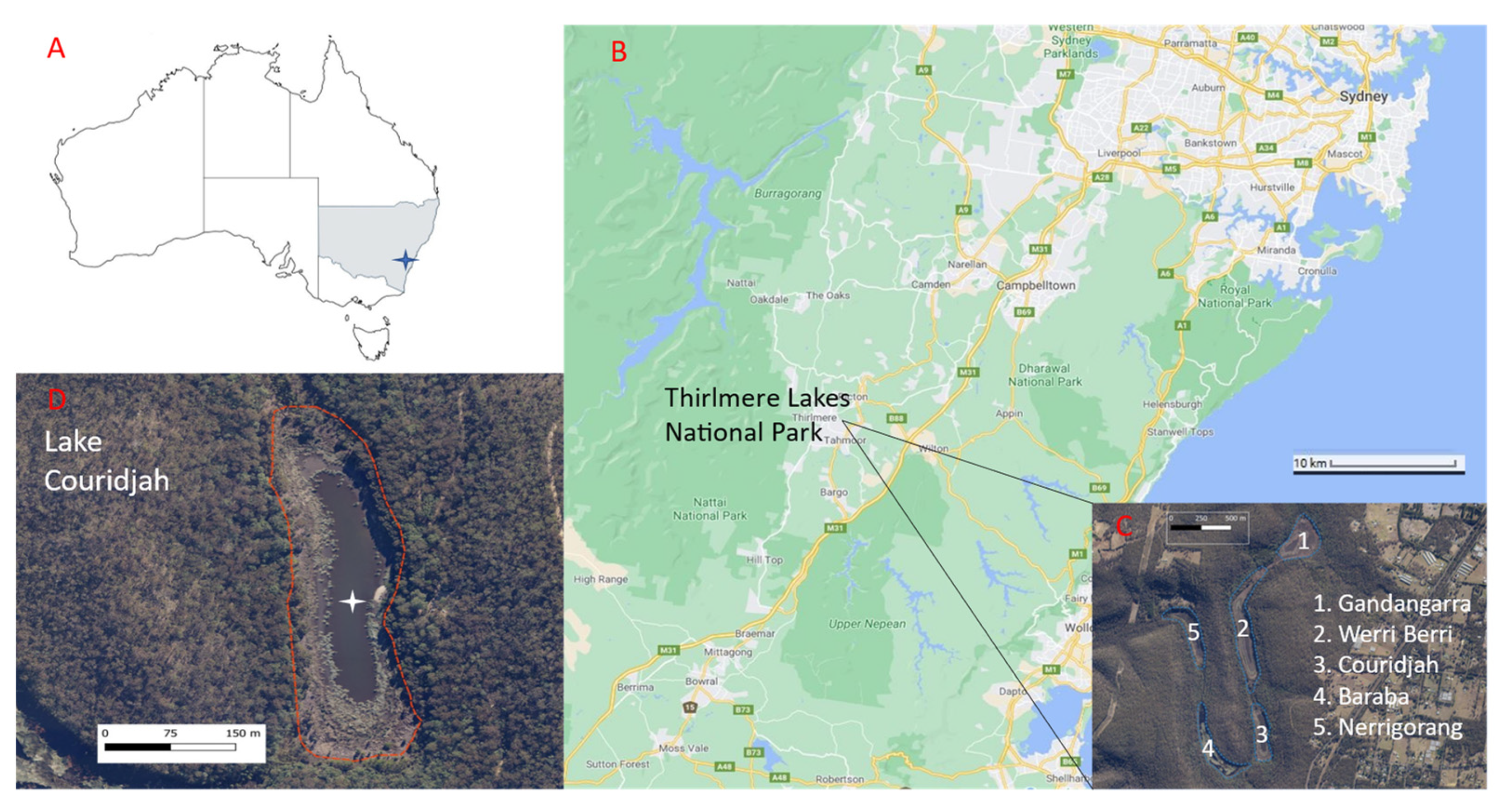
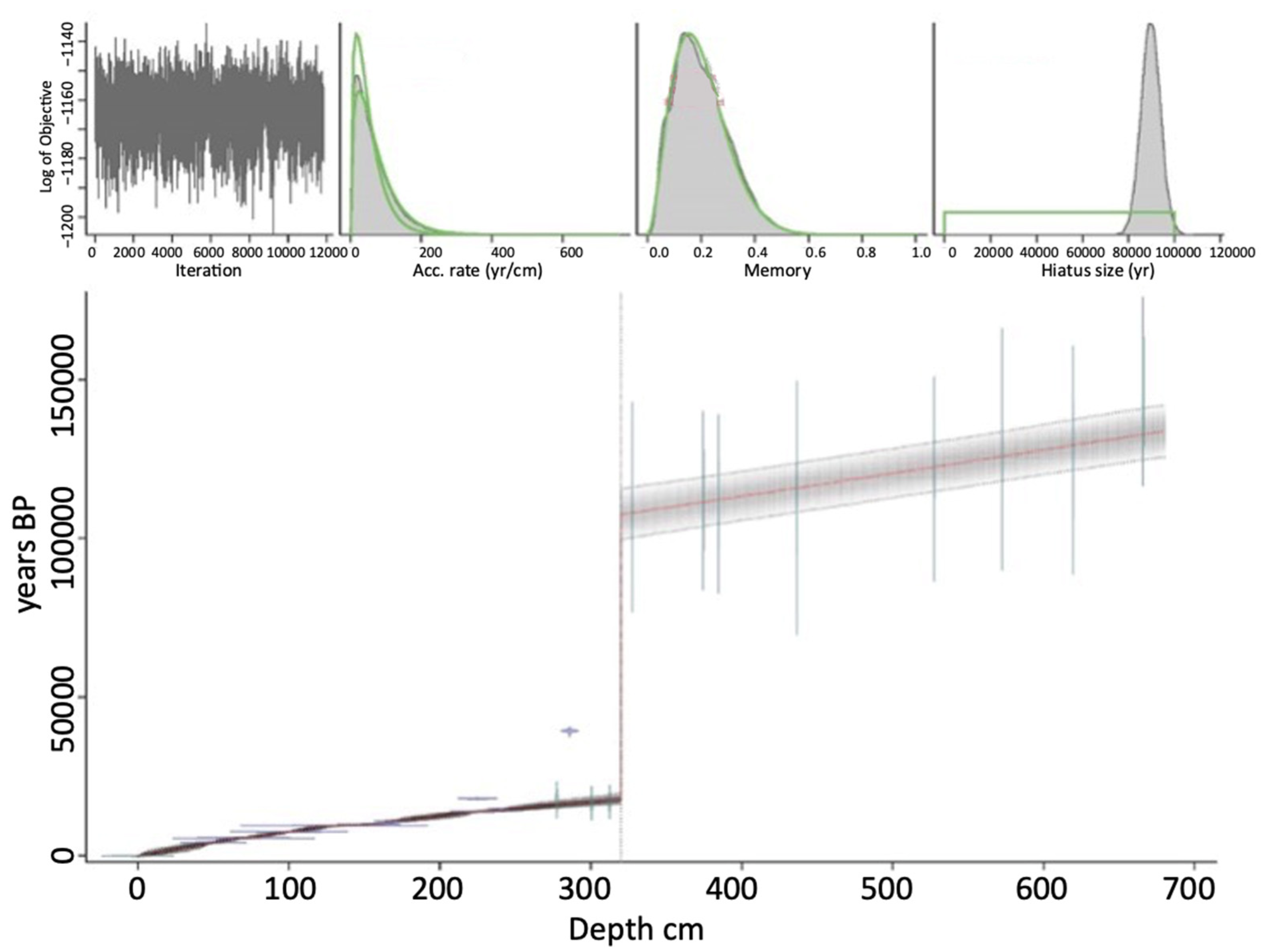
2. Materials and Methods
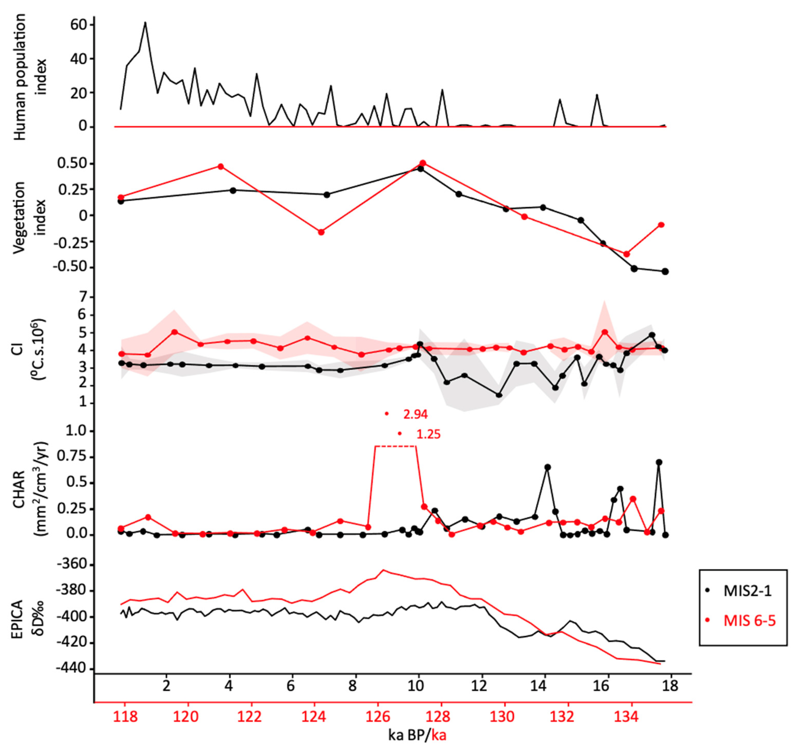
This study used a 6.8-metre core extracted from the middle of Lake Couridjah. The core was split lengthways at the University of Wollongong and subjected to a series of sediment characterization methods and subsampled separately for pollen analysis [28]. LC2 was described previously [28]. The chronology of Forbes et al. [28] was updated by Francke et al. [30] which has been utilized in this study (Figure 2). AMS radiocarbon dating and calibration using the SHCal20 were used on top half of the core (0–320 cm). Single grain optically stimulated luminescence [OSL] reported as kiloannum, (ka) was used to date the bottom half (320–680 cm). The chronology of Francke et al. [30] considered and modelled the LC2 core as a single record with a hiatus specified at 320 cm. The hiatus was modelled to have occurred from 107.5 to 17.7 ka, covering 89.8 ka. All data is plotted using the median age estimation.
Macrocharcoal (<250μm) was separated from sediments to examine fire occurrence within ≈101–103 metres of the lake [31]. A total of 95 volumetric sub-samples were taken from the LC2 core at 5–10 cm intervals for charcoal analysis. Constantine and Mooney [23] showed that the use of oxidants can preferentially remove the proportion of lightly-charred material that is less recalcitrant to oxidative digestion, with an oxidative threshold for charred material between ~400–450° C (CI 3–3.2). In this study, charcoal was concentrated by immersion in reverse osmosis (R0) H2O rather than an oxidant to avoid eliminating the low intensity fraction of charcoal. Sediment was gently washed through a 250 μm sieve after 24 h of emersion in R0 H2O, then hand separated under a dissecting microscope. The concentrated charcoal was photographed and quantified using the image analysis software ImageJ version 1.52a [32]. The concentration of charcoal was quantified per cm3 of each subsample as area (mm2/cm3). Charcoal Accumulation Rate (CHAR) [33,34] was then calculated by dividing the charcoal concentration by the deposition time, estimated from the Bayesian age-depth model.
A modified version of CI, following the protocols of Constantine et al. [25] was used in this study. Individual charcoal particles (1–4 particles) from each depth where charcoal was present were scanned (n = 345) using an ATR-FTIR spectrometer. Spectra were measured in absorbance mode at a range of 4000–650 cm−1 at 4 cm−1 resolution with a wavenumber spacing of 1, with 8 scans accumulated per sample. The spectra were then modelled using the PLS-R model developed in Constantine et al. [25].
A time series of summed probability plots of radiocarbon data from the AustArch dataset encompassing south-eastern Australia [35,36] was used here to estimate the population of the Indigenous people of south-eastern Australia and to consider the role of people in the fire regimes of the Thirlmere lakes region. While increasingly advanced techniques to manipulate and interpret radiocarbon data have evolved in recent years, this approach provides a straightforward indication of human activity for the purpose of this paper; and aligns with more extensive analysis of past populations [29,37,38].
In this work, the methods of Francke et al. [30] are used on LC2 palynological data [28] to calculate an index of the past canopy and mid-storey vegetation cover at Lake Couridjah. A Partial Least Squares Regression (PLS-R) between the relative abundances of Myrtaceae (Myrt.), Casuarinaceae (Casu.), Acacia, Asteraceae Asteroideae or Tubuliflorae (Ast. tub.) and Poaceae (as predictor variables) and catchment erosion, quantified using uranium-isotope derived sediment residence times (as a response variable) in the Lake Couridjah catchment, was applied to determine the influence of vegetation on sediment erosion suggest that the changes in pollen abundances in the PLS-R model represent an aspect of the vegetation community structure (physiognomy) and particularly the foliage projective cover of the canopy (e.g., open versus more closed).

3. Results

The age depth model inferred a basal age of 133.7 ka at a depth of 665–667 cm with a hiatus of 89.8 ka between ~17.7 ka and 107.5 ka. The top 0–320 cm of LC2 spans approximately 0–17.7 ka BP and 320 to 665 cm 107.5–133.7 ka and therefore these periods are broadly equivalent to Termination 1 and MIS 1 and Glacial Termination II and MIS 5e, respectively.
Charcoal Accumulation Rate (CHAR) and Charring Intensity (CI), along with the vegetation index for Lake Couridjah [30], human population index [38] and the EPICA temperature record from Antarctica [39] have been overlaid across the late glacial transitions and interglacials of MIS 6-5 and 2-1 (Figure 3). CHAR was higher and more variable during both late glacial-to-interglacial transitions, and relatively low and stable during the interglacial periods. There was a statistically significant difference in Charring Intensity between MIS 6-5 and 2-1 (t(216) = −11.5165, p = 1.533−24). CI was relatively high and stable throughout MIS 6-5 (µ = 4.3, σ = 0.62) but lower and less variable during MIS 2-1 (µ = 3.3, σ = 0.92). Importantly, there is noticeably increased variability in mean CI during the late-Pleistocene and early Holocene period before stabilizing to a consistently higher level after 10 ka BP. This consistency is despite major climate variations, including the mid Holocene climatic optimum [40] and the mid-to-late Holocene intensification of El-Niño Southern Oscillation (ENSO) which are widely believed to have affected fire regimes [41]. Changes in vegetation structure (Figure 3) suggest the environment underwent a shift towards taller and more closed vegetation communities during these late glacial transitions and remained relatively stable in the interglacial periods.

4. Discussion

4.1. Fire across Two Glacial—Interglacial Periods

Sea level, climate and environmental conditions were broadly similar across both interglacial periods, though temperatures were slightly warmer [42] and sea levels were somewhat higher [43,44] during the warmest period of the previous interglacial (MIS 5e). The deglacial period of MIS 2-1 was also punctuated by the Antarctic Cold Reversal (ACR), a temporary return to glacial-like conditions between ~14.7–13 ka BP [45].
Our data displays a remarkable similarity in vegetation abundance and CHAR across both transitions. At broad timescales both datasets correlate to the Antarctic deuterium (ẟD) record and strongly support changes to vegetation and fire as a response to climate forcing. Notably, the higher temperatures suggested by the Antarctic ẟD record of MIS 5e compared to MIS 2-1 corresponds to increased CHAR, suggesting heightened biomass burning during that slightly warmer period. At Lake Couridjah, both late glacials had elevated CHAR (in comparison to the interglacial periods) suggesting that these periods also witnessed elevated biomass burning as climate recovered and vegetation was re-established. Fire severity during the interglacial transition of MIS 6-5 was higher, on average, than that of MIS 2-1, and less variable, which could be indicative of greater vegetation density in the warmer environment.
In Australia, vegetation south of 30° latitude was reduced to herb- and grass-dominated taxa during the Last Glacial Maximum (LGM) (28.6 (±2.8)–17.7 (±2.2) ka BP) [46] and would have experienced limited burning. During deglacial periods, as temperatures and CO2 rose and moisture availability increased in the region [47], the vegetation clearly underwent change, and these were likely to include changes in community composition, physiognomy and structure and hence biomass and fuel loads.
During both late glacial to interglacial transitions, forest composition shifted from a Casuarinaceae-dominated woodland to a Myrtaceae forest around Lake Couridjah [28]. Paradoxically, biomass burnt decreased once interglacial conditions and vegetation had stabilised. This is at odds with more generalised views of how fire regimes alter into an interglacial period (which are often assumed to have more fire) and generalisations about fire regimes in landscapes dominated by pyrophytic Eucalypts [48].
The high and variable CHAR during the late glacial—interglacial transitions has been described for MIS 2-1 in the Sydney region previously [49] and in regional syntheses [16]. CHAR at Lake Couridjah increased in conjunction with increased tree and shrub cover [28] during the early deglacial period, which is unexpected as Mooney et al. [47] argued that cool (and dry) conditions continued until at least ~12 ka BP in the Sydney region. However, arboreal vegetation was still present in the Lake Couridjah catchment during the early deglacial period, suggesting sufficient biomass to sustain wildfires within the catchment. The highly variable CI and increased CHAR during the ACR, followed by continued warming afterwards, also suggests the increased fires were caused by variable climate shifts. Recent archaeological models also support lower bio-productive conditions, with a delayed recovery of populations after the LGM until at least the initiation of sea-level rise at ~14 ka BP [50,51]. Documenting such an increase across two late glacial-to-interglacial transitions supports a hypothesis that climate instability promotes fire in these dry sclerophyll forests. Bradstock [52] described a non-linear relationship between moisture availability and the productivity of the ecosystem and fire, which he defined as a series of switches which all must be tripped in order for fires to occur. The instability of glacial—interglacial transitions may produce conditions conducive to tripping these switches.
It should also be noted that the period of enhanced fire during the late glacials might have been related to some aspect of climactic upheaval that is perhaps more cryptic, for example related to increased lightning from frequent (dry) storms [53,54], altered seasonality of rainfall, or relatively short-term climatic variability (e.g., across El Niño Southern Oscillation (ENSO) or Interdecadal Pacific Oscillation (IPO)-like cycles) that contributed to alterations to fire across the glacial/interglacial transitions.
During both glacial/interglacial transitions CHAR was relatively high and variable in comparison to the lower levels recorded during the respective interglacial periods. The MIS 6-5 transition included large spikes in CHAR, some 7.5 ka BP after the Termination, and this corresponds to the start of MIS 5e. The sharp increase in biomass burnt during the start of MIS 5e is not a feature of MIS 2-1, as discussed below.

4.2. Is There An Anthropogenic Signal in Fire at Lake Couridjah?

It is notable that the accumulation of charcoal at Lake Couridjah as indicated by CHAR, was similar across both late glacial—interglacial transitions, but CI was different, particularly during the terminal Pleistocene and early Holocene. This suggests that CI, our index of fire severity, better distinguishes the nature of the fires that were burning, and hence allows differentiation of anthropogenic burning practices (e.g., low intensity, cooler fires) from natural background fires. The difference in the CI index and CHAR indices furthermore potentially offers insight into the issues of decomposition-destruction of lightly-pyrolyzed charcoal in the previous interglacial compared to Holocene evident in the 13C NMR data [28]. The lower levels of CHAR at the beginning of the Holocene, compared to MIS 5e (~128 ka), suggest the size of fires was also smaller, potentially a consequence of frequent, low intensity fires, as demonstrated by the lower CI values.
Using reconstructed human populations based on summed probabilities of 14C data (Figure 3), Williams et al. [37,38,55] argued that the climate and limited resources of the last glacial period kept Indigenous populations relatively low and occupying small cryptic refuges across the continent, and especially southeast Australia. As the climate improved following the LGM, previously marginal landscapes again became habitable, encouraging increase activity and migration from these refuges [38]. Barry et al. [50] and Williams et al. [51] found that the expansion of populations out of Sydney Basin refugia began soon after Meltwater Pulse 1A (14.6–14.3 ka BP), which is closely mirrors when the deflection of fire is at a maximum in the Lake Couridjah record.
During MIS 2-1, fire severity was lower, but with higher variability during the Pleistocene—Holocene transition, suggesting that frequent low intensity fires were occasionally punctuated by large conflagrations, and that fire was not always under control, likely a consequence of the increasing accumulation of biomass as the climate ameliorated. As has been previously proposed by Williams et al. [13], it may also suggest that anthropogenic burning was not an established or regularly adopted behaviour during this period and may have formed part of substantial societal change evident only in the early-mid Holocene. There was a progressive decrease in CI from the early Holocene at Lake Couridjah. As climate, resources and population levels began to recover after the MIS 2-1 transition, fire severity reached a maximum (and so equivalent to the MIS 6-5 example) at about 11.6 ka BP, corresponding to the Pleistocene-Holocene boundary and the Antarctic Thermal Maximum. This arguably suggests climate remained the primary driver of fires, despite the potential increased use of Thirlmere Lakes by people.
From ~10 ka BP to present, subtle changes in the fire regime suggest the continued influence of people in the Thirlmere landscape. Despite relative stability in the climate during the Holocene, there were fluctuations (e.g., the Holocene Climate Optimum at ~7.6–6.2 ka BP and the onset of modern ENSO at ~4.0 ka BP [47], that would likely have affected fires regimes. However, the stable but lower CI in MIS 1 compared with 5e, and the lower CHAR, indicates less severe fires, with the data more akin to regular, cooler burns. This signal is consistent with landscape management as seen in contemporary Indigenous activities today. These small, low severity anthropogenic burns could have maintained a more open vegetation structure (e.g., with a less dense canopy or where sub-canopy components reduced fuel loads or provided less connectivity reducing fire spread or the likelihood of fire spreading as canopies ignited). Forbes et al. [28] also found that the percentage of pyrogenic carbon (SPAC), the residual carbon fraction left over after high temperature combustion, was also generally higher in MIS 6-5 than in MIS 2-1, supporting our contention that there is an anthropogenic signal in the fire regime at Lake Couridjah during the late Pleistocene and Holocene.

5. Conclusions

Aspects of the fire regimes of Lake Couridjah spanning two glacial/interglacial periods have been presented here. The results demonstrate that increased fire is a feature of both glacial transitions, suggesting that ameliorating conditions after glacial periods resulted in more increased biomass burnt than during more stable climatic periods. It is likely that ameliorating climate increased biomass and perhaps other cryptic environmental conditions (e.g., increased lightning), leading to more fire in the landscape during these climatic changes.
Importantly, this record spanning the previous two glacial-interglacial cycles suggests that the use of CHAR in isolation, may not be able to differentiate between low-intensity fires (e.g., anthropogenic ignitions) and fires caused by shifting climatic and environmental conditions. It is also problematic in accurately accounting for environmental oxidation and subsequent loss of low pyrolyzed charcoal over long term Quaternary records. In contrast, the CI metric of fire severity was reduced and more variable across the ACR and the Pleistocene/Holocene transition, compared to the MIS 6-5 transition. This improved method suggests that lower, cooler fires were common in the terminal Pleistocene and Holocene periods. Based on ethnographic observations, this type of fire regime is consistent with Indigenous land use burning practises and suggests that active landscape management was established by the onset of the Holocene some 10,000 years ago. Subdued fire values are evident as early as 16,000 years ago and may suggest periodic anthropogenic burning extends back to this period, but significant variability suggest this was intermittent and/or irregular.
While Indigenous anthropogenic burning prior to colonial contact was typically focussed on a range of localised activities, such as improving hunting and traversing the landscape, it appears to have indirectly modified broader vegetation structures and reduced fire extremes throughout the Holocene. Our data, therefore, provides some level of support for the current bushfire management approaches and the use of Indigenous burning practises in reducing extreme fire events. Unfortunately, results of this approach may require significant time to see fire regime change, potentially across multiple generations.

Author Contributions

Conceptualization, M.C.IV and S.D.M.; Methodology, M.C.IV, A.F. and M.F.; Formal analysis, M.C.IV, H.C. and X.Z.; Investigation, M.C.IV and S.D.M., A.N.W.; Writing—original draft, M.C.IV, A.N.W. and S.D.M.; Writing—review and editing, A.N.W., H.C., M.F. and T.J.C. All authors have read and agreed to the published version of the manuscript.

Funding

This research received no external funding.

Data Availability Statement

Data may be available upon request from Mark Constantine IV.

Acknowledgments

Work on LC2 was originally undertaken by Emily Barber and funded by the New South Wales state government, DPIE grant (TLRP1) to T. Cohen, S. Mooney. Mark Constantine’s work was partially funded by a Research Training Program scholarship from the University of New South Wales.

Conflicts of Interest

The authors declare no conflict of interest.

References

  1. Clarkson, C.; Jacobs, Z.; Marwick, B.; Fullagar, R.; Wallis, L.; Smith, M.; Roberts, R.G.; Hayes, E.; Lowe, K.; Carah, X.; et al. Human occupation of northern Australia by 65,000 years ago. Nature 2017, 547, 306–310. [Google Scholar] [CrossRef] [PubMed] [Green Version]
  2. O’Connell, J.F.; Allen, J. Pre-LGM Sahul (Australia-New Guinea) and the archaeology of early modern humans. In Rethinking the Human Revolution; MacDonalnd Institute for Archaeological Research: Cambridge, UK, 2007. [Google Scholar]
  3. Rule, S.; Brook, B.R.; Haberle, S.G.; Turney, C.S.M.; Kershaw, A.P.; Johnson, C.N. The Aftermath of Megafaunal in Pleistocene Australia. Science 2012, 335, 1483–1486. [Google Scholar] [CrossRef] [PubMed]
  4. Van Der Kaars, S.; Miller, G.H.; Turney, C.S.M.; Cook, E.J.; Nürnberg, D.; Schönfeld, J.; Kershaw, A.P.; Lehman, S.J. Humans rather than climate the primary cause of Pleistocene megafaunal extinction in Australia. Nat. Commun. 2017, 8, 14142. [Google Scholar] [CrossRef] [Green Version]
  5. Mooney, S.; Harrison, S.P.; Bartlein, P.J.; Stevenson, J. The prehistory of fire in Australia. In Flammable Australia: Fire Regimes, Biodiversity, and Ecosystems in a Changing World; Bradstock, R.A., Gill, A.M., Williams, R.J., Eds.; CSIRO Publishing: Paramatta, Australia, 2012; pp. 3–27. [Google Scholar]
  6. Head, L. Prehistoric aboriginal impacts on australian vegetation: An assessment of the evidence. Aust. Geogr. 1989, 20, 37–46. [Google Scholar] [CrossRef]
  7. Smith, M. The Archaeology of Australia’s Deserts, 3rd ed.; Cambridge University Press: Cambridge, UK, 2013; p. 424. [Google Scholar]
  8. Bliege Bird, R.; Bird, D.W.; Codding, B.F.; Parker, C.H.; Jones, J.H. The “fire stick farming” hypothesis: Australian Aboriginal foraging strategies, biodiversity, and anthropogenic fire mosaics. Proc. Natl. Acad. Sci. USA 2008, 105, 14796–14801. [Google Scholar] [CrossRef] [Green Version]
  9. Flannery, T.F. The Future Eaters: An Ecological History of the Australasian Lands and People; Grove Press: Atlanta, GA, USA, 1994; p. 432. [Google Scholar]
  10. Jones, R. Fire Stick Farming. Aust. Nat. Hist. 1969, 16, 224–228. [Google Scholar] [CrossRef] [Green Version]
  11. Johnson, C.N. Fire, people and ecosystem change in Pleistocene Australia. Aust. J. Bot. 2016, 64, 643–651. [Google Scholar] [CrossRef]
  12. Black, M.P.; Mooney, S. The response of Aboriginal burning practices to population levels and El Ninõ—Southern Oscillation events during the mid- to late-Holocene: A case study from the Sydney basin using charcoal and pollen analysis. Aust. Geogr. 2007, 38, 37–52. [Google Scholar] [CrossRef]
  13. Williams, A.N.; Mooney, S.; Sisson, S.A.; Marlon, J. Exploring the relationship between Aboriginal population indices and fire in Australia over the last 20,000 years. Palaeogeogr. Palaeoclimatol. Palaeoecol. 2015, 432, 49–57. [Google Scholar] [CrossRef] [Green Version]
  14. Mariani, M.; Connor, S.E.; Theuerkauf, M.; Herbert, A.; Kuneš, P.; Bowman, D.; Fletcher, M.S.; Head, L.; Kershaw, A.P.; Haberle, S.G.; et al. Disruption of cultural burning promotes shrub encroachment and unprecedented wildfires. Front. Ecol. Environ. 2022, 20, 292–300. [Google Scholar] [CrossRef]
  15. Kershaw, A.P. Late Quaternary Vegetation of the Atheron Tableland, North-east Queensland, Australia. Ph.D. Thesis, Monash University, Melbourne, Australia, 1973. [Google Scholar]
  16. Mooney, S.; Harrison, S.P.; Bartlein, P.J.; Daniau, A.L.; Stevenson, J.; Brownlie, K.C.; Buckman, S.; Cupper, M.; Luly, J.; Black, M.; et al. Late Quaternary fire regimes of Australasia. Quat. Sci. Rev. 2011, 30, 28–46. [Google Scholar] [CrossRef]
  17. Thevenon, F.; Williamson, D.; Bard, E.; Anselmetti, F.S.; Beaufort, L.; Cachier, H. Combining charcoal and elemental black carbon analysis in sedimentary archives: Implications for past fire regimes, the pyrogenic carbon cycle, and the human-climate interactions. Glob. Planet. Chang. 2010, 72, 381–389. [Google Scholar] [CrossRef] [Green Version]
  18. Tsakiridou, M.; Cunningham, L.; Hardiman, M. Toward a standardized procedure for charcoal analysis. Quat. Res. 2021, 99, 329–340. [Google Scholar] [CrossRef]
  19. Hennebelle, A.; Aleman, J.C.; Ali, A.A.; Bergeron, Y.; Carcaillet, C.; Grondin, P.; Landry, J.; Blarquez, O. The reconstruction of burned area and fire severity using charcoal from boreal lake sediments. Holocene 2020, 30, 1400–1409. [Google Scholar] [CrossRef]
  20. Higuera, P.E.; Peters, M.E.; Brubaker, L.B.; Gavin, D.G. Understanding the origin and analysis of sediment-charcoal records with a simulation model. Quat. Sci. Rev. 2007, 26, 1790–1809. [Google Scholar] [CrossRef]
  21. Higuera, P.E.; Sprugel, D.G.; Brubaker, L.B. Reconstructing fire regimes with charcoal from small-hollow sediments: A calibration with tree-ring records of fire. Holocene 2005, 15, 238–251. [Google Scholar] [CrossRef]
  22. Higuera, P.E.; Whitlock, C.; Gage, J.A. Linking tree-ring and sediment-charcoal records to reconstruct fire occurrence and area burned in subalpine forests of yellowstone National Park, USA. Holocene 2011, 21, 327–341. [Google Scholar] [CrossRef] [Green Version]
  23. Constantine, M.; Mooney, S. Widely used charcoal analysis method in paleo studies involving NaOCl results in loss of charcoal formed below 400 °C. Holocene 2021, 32, 1358–1362. [Google Scholar] [CrossRef]
  24. Constantine, I.V.M.; Zhu, X.; Cadd, H.; Mooney, S. Investigating the Effect of Oxidants on the Quantification and Characterization of Charcoal in Two Southeast Australian Sedimentary Records. Fire 2023, 6, 54. [Google Scholar] [CrossRef]
  25. Constantine, M.; Mooney, S.; Hibbert, B.; Marjo, C.; Bird, M.; Cohen, T.; Forbes, M.; McBeath, A.; Rich, A.; Stride, J. Using charcoal, ATR FTIR and chemometrics to model the intensity of pyrolysis: Exploratory steps towards characterising fire events. Sci. Total Environ. 2021, 783, 1–9. [Google Scholar] [CrossRef]
  26. Pyle, L.A.; Hockaday, W.C.; Boutton, T.; Zygourakis, K.; Kinney, T.J.; Masiello, C.A. Chemical and Isotopic Thresholds in Charring: Implications for the Interpretation of Charcoal Mass and Isotopic Data. Environ. Sci. Technol. 2015, 49, 14057–14064. [Google Scholar] [CrossRef] [PubMed]
  27. Constantine IV, M.; Zhu, X.; Cadd, H.; Mooney, S. The transition from an Indigenous to a European influenced fire regime at Lake Werri Berri, south-east Australia. Holocene 2023, 8, 09596836231151827. [Google Scholar] [CrossRef]
  28. Forbes, M.; Cohen, T.; Jacobs, Z.; Marx, S.; Barber, E.; Dodson, J.; Zamora, A.; Cadd, H.; Francke, A.; Constantine, M.; et al. Comparing interglacials in eastern Australia: A multi-proxy investigation of a new sedimentary record. Quat. Sci. Rev. 2021, 252. [Google Scholar] [CrossRef]
  29. Bradshaw, C.J.A.; Norman, K.; Ulm, S.; Williams, A.N.; Clarkson, C.; Chadœuf, J.; Lin, S.C.; Jacobs, Z.; Roberts, R.G.; Bird, M.I.; et al. Stochastic models support rapid peopling of Late Pleistocene Sahul. Nat. Commun. 2021, 12, 2440. [Google Scholar] [CrossRef]
  30. Francke, A.; Dosseto, A.; Forbes, M.; Cadd, H.; Short, J.; Sherborne-Higgins, B.; Constantine, M.; Tyler, J.; Marx, S.k.; Dodson, J.; et al. Catchment vegetation and erosion controls soil carbon cycling in south-eastern Australia during the last two Glacial-Interglacial cycles. Glob. Planet. Chang. 2022, 217, 103922. [Google Scholar] [CrossRef]
  31. Clark, J.S. Particle motion and the theory of charcoal analysis: Source area, transport, deposition, and sampling. Quat. Res. 1988, 30, 67–80. [Google Scholar] [CrossRef]
  32. Rueden, C.T.; Schindelin, J.; Hiner, M.C.; DeZonia, B.E.; Walter, A.E.; Arena, E.T.; Eliceiri, K.W. ImageJ2: ImageJ for the next generation of scientific image data. BMC Bioinform. 2017, 18, 529. [Google Scholar] [CrossRef] [Green Version]
  33. Long, C.J.; Whitlock, C.; Bartlein, P.J.; Millspaugh, S.H. A 9000-year fire history from the Oregon Coast Range, based on a high-resolution charcoal study. Can. J. For. Res. 1998, 28, 774–787. [Google Scholar] [CrossRef]
  34. Whitlock, C.; Millspaugh, S.H. Testing the assumptions of fire-history studies: An examination of modern charcoal accumulation in Yellowstone National Park, USA. Holocene 1996, 6, 7–15. [Google Scholar] [CrossRef]
  35. Smith, M.A.; Williams, A.N.; Turney, C.S.M.; Cupper, M.L. Human—environment interactions in Australian drylands: Exploratory time- series analysis of archaeological records. Holocene 2008, 3, 389–401. [Google Scholar] [CrossRef]
  36. Williams, A.; Ulm, S.; Smith, M.; Reid, J. AustArch: A Database of 14C and Non-14C Ages from Archaeological Sites in Australia—Composition, Compilation and Review (Data Paper). Internet Archaeol. 2014, 1–12. [Google Scholar] [CrossRef]
  37. Williams, A.N.; Ulm, S.; Cook, A.R.; Langley, M.C.; Collard, M. Human refugia in Australia during the last glacial maximum and terminal pleistocene: A geospatial analysis of the 25-12ka Australian archaeological record. J. Archaeol. Sci. 2013, 40, 4612–4625. [Google Scholar] [CrossRef]
  38. Williams, A.N.; Veth, P.; Steffen, W.; Ulm, S.; Turney, C.S.M.; Reeves, J.M.; Phipps, S.J.; Smith, M. A continental narrative: Human settlement patterns and Australian climate change over the last 35,000 years. Quat. Sci. Rev. 2015, 123, 91–112. [Google Scholar] [CrossRef]
  39. Jouzel, J.; Masson-Delmotte, V.; Cattani, O.; Dreyfus, G.; Falourd, S.; Hoffmann, G.; Minster, B.; Nouet, J.; Barnola, J.M.; Chappellaz, J.; et al. Orbital and millennial antarctic climate variability over the past 800,000 years. Science 2007, 317, 793–796. [Google Scholar] [CrossRef] [PubMed] [Green Version]
  40. De Deckker, P. The Holocene hypsithermal in the Australian region. Quat. Sci. Adv. 2022, 7, 100061. [Google Scholar] [CrossRef]
  41. Fletcher, M.S.; Wolfe, B.B.; Whitlock, C.; Pompeani, D.P.; Heijnis, H.; Haberle, S.G.; Gadd, P.S.; Bowman, D.M.J.S. The legacy of mid-holocene fire on a Tasmanian montane landscape. J. Biogeogr. 2014, 41, 476–488. [Google Scholar] [CrossRef]
  42. Lunt, D.J.; Abe-Ouchi, A.; Bakker, P.; Berger, A.; Braconnot, P.; Charbit, S.; Fischer, N.; Herold, N.; Jungclaus, J.H.; Khon, V.C.; et al. A multi-model assessment of last interglacial temperatures. Clim. Past 2013, 9, 699–717. [Google Scholar] [CrossRef] [Green Version]
  43. Marshall, J.F.; Thom, B.G. The sea level in the last interglacial. Nature 1976, 263, 120–121. [Google Scholar] [CrossRef]
  44. Pan, T.Y.; Murray-Wallace, C.V.; Dosseto, A.; Bourman, R.P. The last interglacial (MIS 5e) sea level highstand from a tectonically stable far-field setting, Yorke Peninsula, southern Australia. Mar. Geol. 2018, 398, 126–136. [Google Scholar] [CrossRef]
  45. Pedro, J.B.; Bostock, H.C.; Bitz, C.M.; He, F.; Vandergoes, M.J.; Steig, E.J.; Chase, B.M.; Krause, C.E.; Rasmussen, S.O.; Markle, B.R.; et al. The spatial extent and dynamics of the Antarctic Cold Reversal. Nat. Geosci. 2016, 9, 51–55. [Google Scholar] [CrossRef]
  46. Cadd, H.; Petherick, L.; Tyler, J.; Herbert, A.; Cohen, T.J.; Sniderman, K.; Barrows, T.T.; Fulop, R.H.; Knight, J.; Kershaw, A.P.; et al. A continental perspective on the timing of environmental change during the last glacial stage in Australia. Quat. Res. 2021, 102, 5–23. [Google Scholar] [CrossRef]
  47. Mooney, S.; Martin, L.; Goff, J.; Young, A.R.M. Sedimentation and organic content in the mires and other sites of sediment accumulation in the Sydney region, eastern Australia, in the period after the Last Glacial Maximum. Quat. Sci. Rev. 2021, 272, 107216. [Google Scholar] [CrossRef]
  48. Haberle, S.G.; Ledru, M.P. Correlations among charcoal records of fires from the past 16, 000 years in Indonesia, Papua New Guinea, and Central and South America. Quat. Res. 2001, 55, 97–104. [Google Scholar] [CrossRef] [Green Version]
  49. Black, M.P.; Mooney, S.; Attenbrow, V. Implications of a 14 200 year contiguous fire record for understanding human-climate relationships at Goochs Swamp, New South Wales, Australia. Holocene 2008, 18, 437–447. [Google Scholar] [CrossRef]
  50. Barry, L.; Graham, I.T.; Mooney, S.; Toms, P.S.; Wood, J.C.; Williams, A.N. Tracking an exotic raw material: Aboriginal movement through the Blue Mountains, Sydney, NSW during the Terminal Pleistocene. Aust. Archaeol. 2021, 87, 63–74. [Google Scholar] [CrossRef]
  51. Williams, A.N.; McDonald, J.; Atkinson, F.; Toms, P.S.; Hobbs, A.; Barry, L.; Sapienza, T.; Wood, J.C.; Doelman, T. Reports Was Aboriginal population recovery delayed after the Last Glacial Maximum ? A synthesis of a terminal Pleistocene deposit from the Sydney. J. Archaeol. Sci. Rep. 2021, 40, 103225. [Google Scholar] [CrossRef]
  52. Bradstock, R.A.; Hammill, K.A.; Collins, L.; Price, O. Effects of weather, fuel and terrain on fire severity in topographically diverse landscapes of south-eastern Australia. Landsc. Ecol. 2010, 25, 607–619. [Google Scholar] [CrossRef]
  53. Enright, N.J.; Thomas, I. Pre-European fire regimes in Australian ecosystems. Geogr. Compass 2008, 2, 979–1011. [Google Scholar] [CrossRef]
  54. Kuleshov, Y.; Mackerras, D.; Darveniza, M. Spatial distribution and frequency of lightning activity and lightning flash density maps for Australia. J. Geophys. Res. Atmos. 2006, 111, 1–14. [Google Scholar] [CrossRef] [Green Version]
  55. Williams, A.N.; Ulm, S.; Turney, C.S.M.; Rohde, D.; White, G. Holocene demographic changes and the emergence of complex societies in prehistoric Australia. PLoS ONE 2015, 10, e0128661. [Google Scholar] [CrossRef]
Figure 1. Location of Lake Couridjah (D) in relation to the Thirlmere Lakes National Park (C), Sydney metropolitan area (B) (Google Maps, 2022) and Australia (New South Wales is shaded) (A). The white star (D) marks the location where LC2 was cored.
Fire 06 00152 g001
Figure 2. Age–depth model of LC2. An 89,700-year hiatus exists at 320 cm (~17.7–107.5 ka). OSL dates are represented in this diagram as light blue vertical lines. Radiocarbon dates are represented as light purple shaded four-point stars. Three OSL ages between 275–315 cm produced statistically identical ages of between 17.7 ± 1.4 ka and 16.0 ± 1.3 ka. The radiocarbon sample at t he same depth range (286 cm) returned an age of 39,244–38,248 years BP and was excluded from the model by the Bacon software program. The grey lines and shading represent 95% confidence intervals.
Fire 06 00152 g002
Figure 3. Overlay of MIS 6-5 (red) and 2-1 (black). Summed probability plots of archaeological data from south-eastern Australia represent an index for human activity levels [36]. Vegetation Cover represents the relationship between vegetation abundance and catchment erosion [30]. The mean Charring Intensity with 95% confidence intervals (shaded represents fire severity. The Charcoal Accumulation Rate (CHAR) or mm2/cm3/yr, represents relative biomass burnt. Changes in Antarctic temperature are represented by the ẟD record from EPICA dome C [39].
Fire 06 00152 g003
Disclaimer/Publisher’s Note: The statements, opinions and data contained in all publications are solely those of the individual author(s) and contributor(s) and not of MDPI and/or the editor(s). MDPI and/or the editor(s) disclaim responsibility for any injury to people or property resulting from any ideas, methods, instructions or products referred to in the content.

