
Mapping Long-Term Changes in Mangrove Species Composition and Distribution in the Sundarbans


Abstract
:1. Introduction
2. Materials and Methods
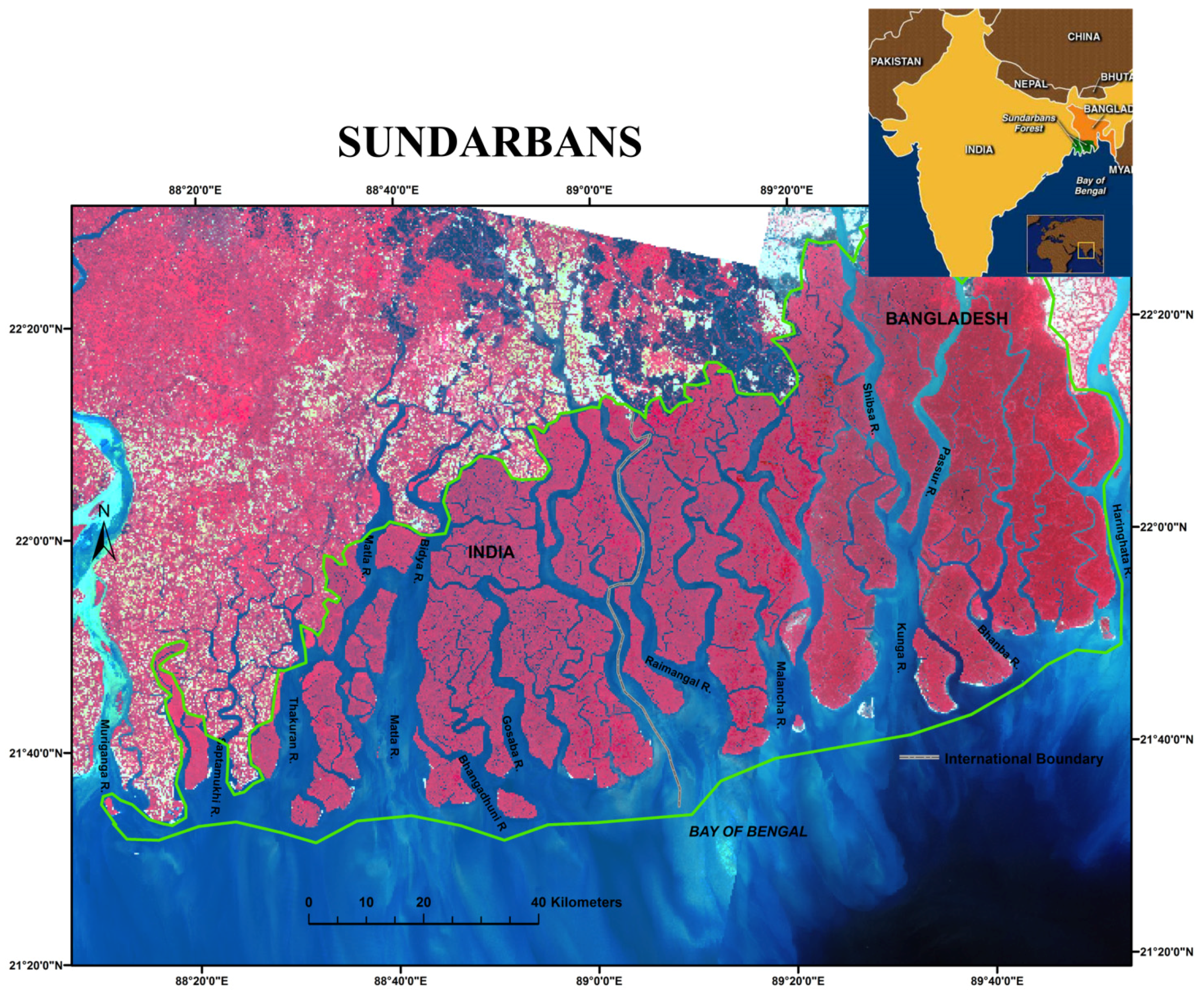
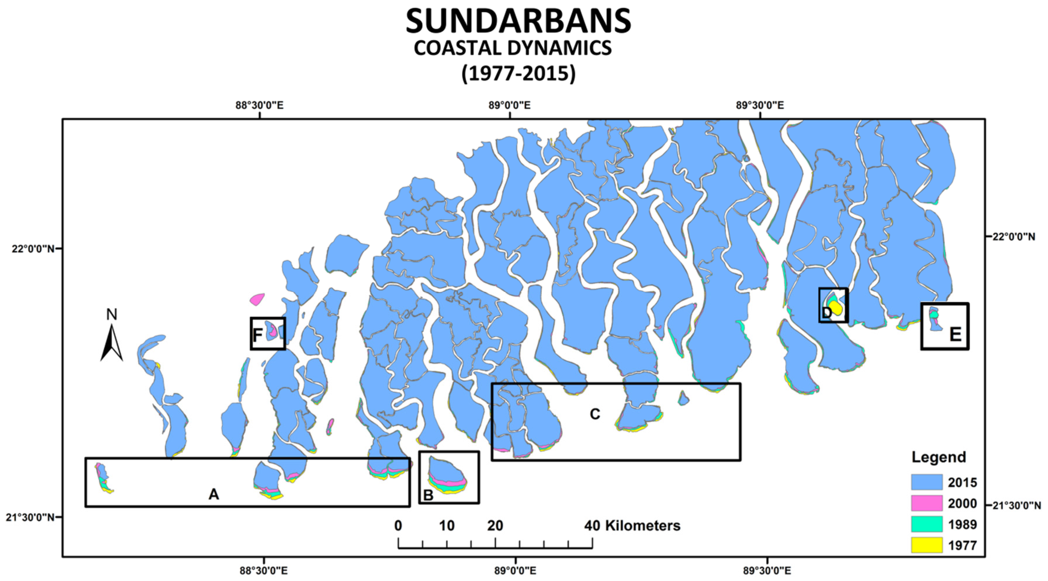
2.1. Study Area
2.2. Images Used
2.3. Image Preprocessing
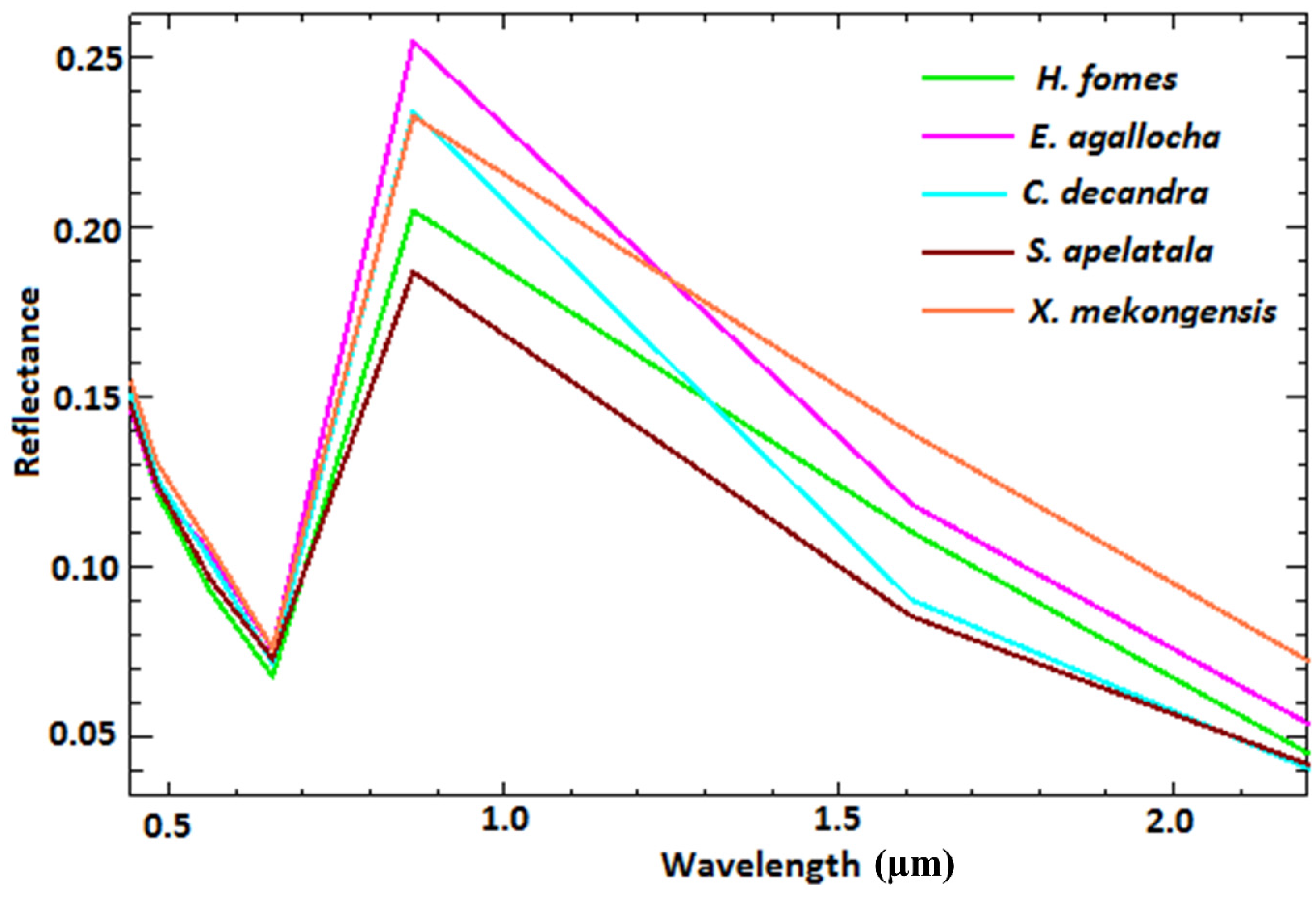
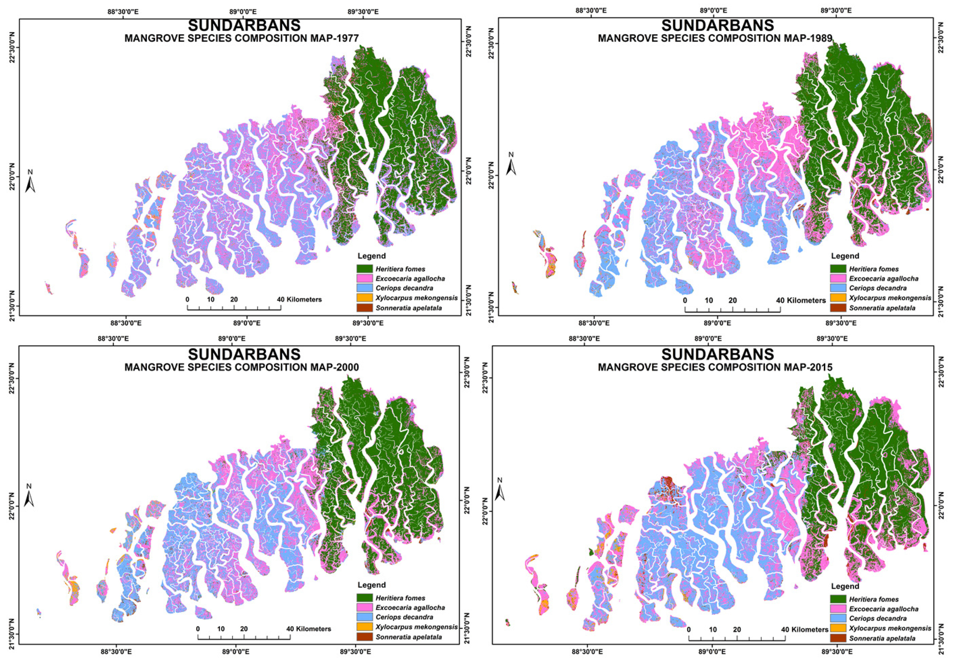
2.4. Image Classification
2.5. Change Detection Analysis
2.6. Classification Accuracy
3. Results
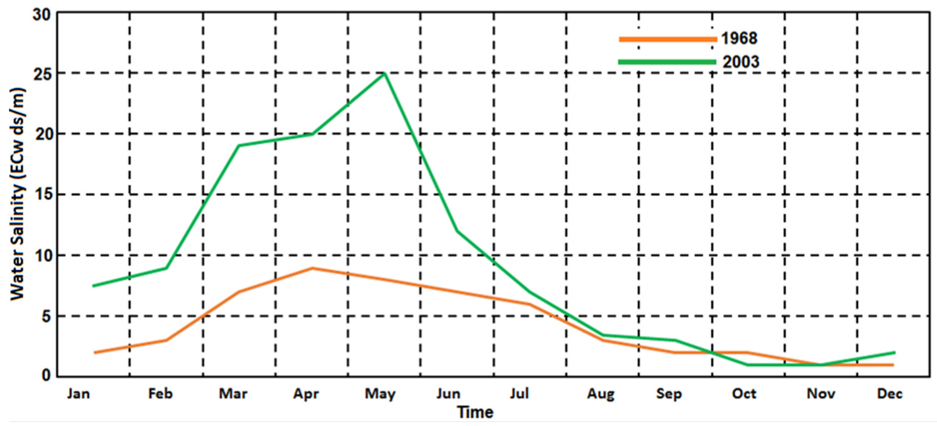
4. Discussion
5. Conclusions
Author Contributions
Conflicts of Interest
References
- Giri, C.; Ochieng, E.; Tieszen, L.L.; Zhu, Z.; Singh, A.; Loveland, T.; Duke, N. Status and distribution of mangrove forests of the world using earth observation satellite data. Glob. Ecol. Biogeogr. 2011, 20, 154–159. [Google Scholar] [CrossRef]
- Marchio, D.A.; Savarese, M.; Bovard, B.; Mitsch, W.J. Carbon Sequestration and Sedimentation in Mangrove Swamps Influenced by Hydrogeomorphic Conditions and Urbanization in Southwest Florida. Forests 2016, 7, 116. [Google Scholar] [CrossRef]
- Cornforth, W.A.; Fatoyinbo, T.E.; Freemantle, T.P.; Pettorelli, N. Advanced land observing satellite phased array type L-band SAR (ALOS PALSAR) to inform the conservation of mangroves: Sundarbans as a case study. Remote Sens. 2013, 5, 224–237. [Google Scholar] [CrossRef]
- Alongi, D.M. Present state and future of the world’s mangrove forests. Environ. Conserv. 2002, 29, 331–349. [Google Scholar] [CrossRef]
- Giri, C.; Muhlhausen, J. Mangrove forest distributions and dynamics in Madagascar (1975–2005). Sensors 2008, 8, 2104–2117. [Google Scholar] [CrossRef] [PubMed]
- Valiela, I.; Bowen, J.L.; York, J.K. Mangrove Forests: One of the World’s Threatened Major Tropical Environments. Bioscience 2001, 51, 807–815. [Google Scholar] [CrossRef]
- Myint, S.W.; Giri, C.; Wang, L.; Zhu, Z.; Gillette, S.C. Identifying mangrove species and their surrounding land use and land cover classes using an object-oriented approach with a lacunarity spatial measure. GISci. Remote Sens. 2008, 45, 188–208. [Google Scholar] [CrossRef]
- Asbridge, E.; Lucas, R.; Ticehurst, C.; Bunting, P. Mangrove response to environmental change in Australia’s Gulf of Carpentaria. Ecol. Evol. 2016, 6, 3523–3539. [Google Scholar] [CrossRef] [PubMed] [Green Version]
- Ghosh, A.; Schmidt, S.; Fickert, T.; Nüsser, M. The Indian Sundarban mangrove forests: History, utilization, conservation strategies and local perception. Diversity 2015, 7, 149–169. [Google Scholar] [CrossRef]
- Spalding, M.; Kainuma, M.; Collins, L. World Atlas of Mangroves; Earthscan: London, UK, 2010; p. 319. [Google Scholar]
- Biswas, S.R.; Choudhury, J.K.; Nishat, A.; Rahman, M.M. Do invasive plants threaten the Sundarbans mangrove forest of Bangladesh? For. Ecol. Manag. 2007, 245, 1–9. [Google Scholar] [CrossRef]
- Hussain, Z.; Acharya, G. Mangroves of the Sundarbans. Volume 2: Bangladesh; International Union for Conservation of Nature AND Natural Resources (IUCN): Gland, Switzerland, 1994; Volume 2, p. 257. [Google Scholar]
- Rahman, M.; Asaduzzaman, M. Ecology of Sundarban, Bangladesh. J. Sci. Found. 2013, 8, 35–47. [Google Scholar] [CrossRef]
- Bose, S. Role of Indian Sunderban Mangroves in Mitigating Climate Impacts: An Appraisal; IOP Conference Series: Earth and Environmental Science; IOP Publishing: Copenhagen, Denmark, 2009. [Google Scholar]
- Giri, C.; Pengra, B.; Zhu, Z.; Singh, A.; Tieszen, L.L. Monitoring mangrove forest dynamics of the Sundarbans in Bangladesh and India using multi-temporal satellite data from 1973 to 2000. Estuar. Coast. Shelf Sci. 2007, 73, 91–100. [Google Scholar] [CrossRef]
- Rahman, L.M. The Sundarbans: A Unique Wilderness of the World; USDA Forest Service Proceedings RMRS-P-15-VOL-2; USDA Forest Service: Ogden, UT, USA, 2000; pp. 143–148.
- Donato, D.C.; Kauffman, J.B.; Murdiyarso, D.; Kurnianto, S.; Stidham, M.; Kanninen, M. Mangroves among the most carbon-rich forests in the tropics. Nat. Geosci. 2011, 4, 293–297. [Google Scholar] [CrossRef]
- Rodda, S.R.; Thumaty, K.C.; Jha, C.S.; Dadhwal, V.K. Seasonal Variations of Carbon Dioxide, Water Vapor and Energy Fluxes in Tropical Indian Mangroves. Forests 2016, 7, 35. [Google Scholar] [CrossRef]
- Islam, M.S. How Worthy is the Sundarbans Mangrove Forest? An Exploratory Study. Environ. Nat. Resour. 2016, 14, 17–25. [Google Scholar]
- Wells, S.; Ravilious, C. In the Front Line: Shoreline Protection and Other Ecosystem Services from Mangroves and Coral Reefs; UNEP/Earthprint: Cambridge, UK, 2006. [Google Scholar]
- Iftekhar, M. An overview of mangrove management strategies in three South Asian countries: Bangladesh, India and Sri Lanka. Int. For. Rev. 2008, 10, 38–51. [Google Scholar] [CrossRef]
- Leong, L. Economic Valuation of the Mangrove Forests in Kuala Selangor, Malaysia. Master’s Thesis, University of Malaya, Kuala Lumpur, Malaysia, 1999. [Google Scholar]
- Cabrera, M.A.; Seijo, J.C.; Euan, J.; Pérez, E. Economic values of ecological services from a mangrove ecosystem. Intercoast Netw. 1998, 32, 1–2. [Google Scholar]
- Costanza, R.; d’Arge, R.; De Groot, R.; Faber, S.; Grasso, M.; Hannon, B.; Limburg, K.; Naeem, S.; O’neill, R.V.; Paruelo, J.; et al. The value of the world’s ecosystem services and natural capital. Nature 1997, 387, 253–260. [Google Scholar] [CrossRef]
- Syed, M.A.; Hussin, Y.A.; Weir, M. Detecting fragmented mangroves in the Sundarbans, Bangladesh using optical and radar satellite images. In Proceedings of the 22nd Asian Conference on Remote Sensing, Singapore, 5–9 November 2001; Volume 5, p. 9.
- Danda, A.A. Surviving in the Sundarbans: Threats and Responses: An Analytical Description of Life in an Indian Riparian Commons. Ph.D. Thesis, University of Twente, Enschede, The Netherland, 2007; pp. 14–23. [Google Scholar]
- Iftekhar, M. Forestry in Bangladesh: An overview. J. For. 2006, 104, 148–153. [Google Scholar]
- Chaudhuri, A.B.; Choudhury, A. Mangroves of the Sundarbans. Volume 1: India; International Union for Conservation of Nature and Natural Resources (IUCN): Bangkok, Thailand, 1994. [Google Scholar]
- Chaffey, D.R.; Miller, F.; Sandom, J. A FOREST INVENTORY of the Sundarbans, Bangladesh; Land Resources Development Centre: Surrey, UK, 1985. [Google Scholar]
- Iftekhar, M.; Saenger, P. Vegetation dynamics in the Bangladesh Sundarbans mangroves: A review of forest inventories. Wetl. Ecol. Manag. 2008, 16, 291–312. [Google Scholar] [CrossRef]
- Wang, L.; Sousa, W.P.; Gong, P.; Biging, G.S. Comparison of IKONOS and QuickBird images for mapping mangrove species on the Caribbean coast of Panama. Remote Sens. Environ. 2004, 91, 432–440. [Google Scholar] [CrossRef]
- Giri, C.; Zhu, Z.; Tieszen, L.; Singh, A.; Gillette, S.; Kelmelis, J. Mangrove forest distributions and dynamics (1975–2005) of the tsunami-affected region of Asia. J. Biogeogr. 2008, 35, 519–528. [Google Scholar] [CrossRef]
- Blasco, F.; Aizpuru, M.; Gers, C. Depletion of the mangroves of Continental Asia. Wetl. Ecol. Manag. 2001, 9, 255–266. [Google Scholar] [CrossRef]
- Dwivedi, R.; Rao, B.; Bhattacharya, S. Mapping wetlands of the Sundaban Delta and it’s environs using ERS-1 SAR data. Int. J. Remote Sens. 1999, 20, 2235–2247. [Google Scholar] [CrossRef]
- Emch, M.; Peterson, M. Mangrove forest cover change in the Bangladesh Sundarbans from 1989–2000: A remote sensing approach. Geocarto Int. 2006, 21, 5–12. [Google Scholar] [CrossRef]
- Iftekhar, M.; Islam, M. Managing mangroves in Bangladesh: A strategy analysis. J. Coast. Conserv. 2004, 10, 139–146. [Google Scholar] [CrossRef]
- Islam, M.J.; Alam, M.S.; Elahi, K.M. Remote sensing for change detection in the Sunderbands, Bangladesh. Geocarto Int. 1997, 12, 91–100. [Google Scholar] [CrossRef]
- Islam, M.T.; Broström, G.; Christensen, K.; Drivdal, M.; Weber, J.; Shendryk, I.; Alwmark, C. Vegetation changes of Sundarbans based on Landsat Imagery analysis between 1975 and 2006. Landsc. Environ. 2014, 8, 1–9. [Google Scholar]
- Giri, S.; Mukhopadhyay, A.; Hazra, S.; Mukherjee, S.; Roy, D.; Ghosh, S.; Mitra, D. A study on abundance and distribution of mangrove species in Indian Sundarban using remote sensing technique. J. Coast. Conserv. 2014, 18, 359–367. [Google Scholar] [CrossRef]
- Choudhury, K.; Waliuzzaman, M.; Nishat, A.; Reza, A.A. The Bangladesh Sundarbans: A Photoreal Sojourn; IUCN Bangladesh Country Office, IUCN the World Conservation Union: Dhaka, Bangladesh, 2001. [Google Scholar]
- Siddiqi, N. Mangrove Forestry in Bangladesh; Institute of Forestry and Environmental Sciences, University of Chittagong: Chittagong, Bangladesh, 2001. [Google Scholar]
- Bhowmik, A.K.; Cabral, P. Cyclone Sidr Impacts on the Sundarbans Floristic Diversity. Earth Sci. Res. 2013, 2, 62. [Google Scholar] [CrossRef]
- Duke, N.C. Mangrove floristics and biogeography. Trop. Mangrove Ecosyst. 1993, 63–100. [Google Scholar] [CrossRef]
- Chavez, P.S. Image-based atmospheric corrections-revisited and improved. Photogramm. Eng. Remote Sens. 1996, 62, 1025–1035. [Google Scholar]
- Rahdary, V.; Najfabdai, S.M.; Khajeddin, S. Land Use and Land Cover Change Detection of Mouteh Wildlife Refuge Using Remotely Sensed Data and Geographic Information System. World Appl. Sci. J. 2008, 3 (Suppl. 1), 113–118. [Google Scholar]
- Chander, G.; Markham, B. Revised Landsat-5 TM radiometric calibration procedures and postcalibration dynamic ranges. IEEE Trans. Geosci. Remote Sens. 2003, 41, 2674–2677. [Google Scholar] [CrossRef]
- Mas, J.-F. Monitoring land-cover changes: A comparison of change detection techniques. Int. J. Remote Sens. 1999, 20, 139–152. [Google Scholar] [CrossRef]
- Coppin, P.; Jonckheere, I.; Nackaerts, K.; Muys, B.; Lambin, E. Digital change detection methods in ecosystem monitoring: A review. Int. J. Remote Sens. 2004, 25, 1565–1596. [Google Scholar] [CrossRef]
- Ghosh, M.K.; Kumar, L.; Roy, C. Monitoring the coastline change of Hatiya Island in Bangladesh using remote sensing techniques. ISPRS J. Photogramm. Remote Sens. 2015, 101, 137–144. [Google Scholar] [CrossRef]
- Chen, C.-F.; Son, N.-T.; Chang, N.-B.; Chen, C.-R.; Chang, L.-Y.; Valdez, M.; Aceituno, J.L. Multi-decadal mangrove forest change detection and prediction in Honduras, Central America, with Landsat imagery and a Markov chain model. Remote Sens. 2013, 5, 6408–6426. [Google Scholar] [CrossRef]
- Foody, G.M. Thematic map comparison. Photogramm. Eng. Remote Sens. 2004, 70, 627–633. [Google Scholar] [CrossRef]
- Foody, G.M. Harshness in image classification accuracy assessment. Int. J. Remote Sens. 2008, 29, 3137–3158. [Google Scholar] [CrossRef]
- Sinha, P.; Kumar, L. Independent two-step thresholding of binary images in inter-annual land cover change/no-change identification. ISPRS J. Photogramm. Remote Sens. 2013, 81, 31–43. [Google Scholar] [CrossRef]
- Sinha, P.; Kumar, L.; Reid, N. Rank-Based Methods for Selection of Landscape Metrics for Land Cover Pattern Change Detection. Remote Sens. 2016, 8, 107. [Google Scholar] [CrossRef]
- Alqurashi, A.F.; Kumar, L.; Sinha, P. Urban Land Cover Change Modelling Using Time-Series Satellite Images: A Case Study of Urban Growth in Five Cities of Saudi Arabia. Remote Sens. 2016, 8, 838. [Google Scholar] [CrossRef]
- Sinha, P.; Kumar, L.; Drielsma, M.; Barrett, T. Time-series effective habitat area (EHA) modeling using cost-benefit raster based technique. Ecol. Inform. 2014, 19, 16–25. [Google Scholar] [CrossRef]
- Congalton, R.G.; Green, K. Assessing the Accuracy of Remotely Sensed Data: Principles and Practices; CRC Press: New York, NY, USA, 2008. [Google Scholar]
- Kumar, L.; Ghosh, M.K. Land cover change detection of Hatiya Island, Bangladesh, using remote sensing techniques. J. Appl. Remote Sens. 2012, 6, 063608. [Google Scholar] [CrossRef]
- Treygo, W.; Dean, P.B. The Environment and Development in Bangladesh: An Overview and Strategy for the Future; Canadian International Development Agency: Ottawa, ON, Canada, 1989. [Google Scholar]
- Congalton, R.G. A review of assessing the accuracy of classifications of remotely sensed data. Remote Sens. Environ. 1991, 37, 35–46. [Google Scholar] [CrossRef]
- Congalton, R.G.; Oderwald, R.G.; Mead, R.A. Assessing Landsat classification accuracy using discrete multivariate analysis statistical techniques. Photogramm. Eng. Remote Sens. 1983, 49, 1671–1678. [Google Scholar]
- Nayak, S.; Bahuguna, A. Application of remote sensing data to monitor mangroves and other coastal vegetation of India. Indian J. Mar. Sci. 2001, 30, 195–213. [Google Scholar]
- Parry, M.L. Climate Change 2007—Impacts, Adaptation and Vulnerability: Working Group II Contribution to the Fourth Assessment Report of the IPCC; Cambridge University Press: Cambridge, UK, 2007; Volume 4. [Google Scholar]
- Duke, N.C.; Meynecke, J.-O.; Dittmann, S.; Ellison, A.M.; Anger, K.; Berger, U.; Cannicci, S.; Diele, K.; Ewel, K.C.; Field, C.D.; et al. A world without mangroves? Science 2007, 317, 41–42. [Google Scholar] [CrossRef] [PubMed] [Green Version]
- Islam, S.; Gnauck, A. Threats to the Sundarbans mangrove wetland ecosystems from transboundary water allocation in the Ganges basin: A preliminary problem analysis. Int. J. Ecol. Econ. Stat. (IJEES) 2009, 13, 64–78. [Google Scholar]
- Karim, A. The physical environment. In Mangroves of the Sundarbans. Volume Two: Bangladesh; Hussain, Z., Acharya, G., Eds.; IUCN: Bangkok, Thailand, 1994; pp. 11–41. [Google Scholar]
- Rahman, M. A comprehensive report on H. fomes (H. fomes) trees with particular reference to top dying in the Sundarbans. In Proceedings of the Seminar on Top Dying of H. fomes, Dhaka, Bangladesh, 11 August 1988.
- Cahoon, D.R.; Hensel, P.F.; Spencer, T.; Reed, D.J.; McKee, K.L.; Saintilan, N. Coastal wetland vulnerability to relative sea-level rise: Wetland elevation trends and process controls. Wetl. Nat. Resour. Manag. 2006, 271–292. [Google Scholar] [CrossRef]
- Rahman, M.M.; Rahman, M.M.; Islam, K.S. The causes of deterioration of Sundarban mangrove forest ecosystem of Bangladesh: Conservation and sustainable management issues. AACL Bioflux 2010, 3, 77–90. [Google Scholar]
- Rahman, A.F.; Dragoni, D.; El-Masri, B. Response of the Sundarbans coastline to sea level rise and decreased sediment flow: A remote sensing assessment. Remote Sens. Environ. 2011, 115, 3121–3128. [Google Scholar] [CrossRef]


| Sensor | Resolution (in Meter) | Path/Row | Date |
|---|---|---|---|
| MSS | 57 | 147-148/45 | 1 February 1977 |
| TM | 28.5 | 137-138/45 | 5 February 1989 |
| ETM+ | 28.5 | 137-138/45 | 28 February 2000 |
| OLI | 30 | 137-138/45 | 4 February 2015 |
| Mangrove Species | Area in Hectares | Area in Percentage (%) | ||||||
|---|---|---|---|---|---|---|---|---|
| 1977 | 1989 | 2000 | 2015 | 1977 | 1989 | 2000 | 2015 | |
| H. fomes | 221,886 | 218,051 | 214,679 | 199,857 | 36.8 | 36.1 | 36.1 | 33.4 |
| E. agallocha | 200,662 | 195,692 | 178,425 | 180,742 | 33.3 | 32.4 | 30.0 | 30.2 |
| C. decandra | 171,590 | 178,972 | 181,238 | 193,698 | 28.5 | 29.6 | 30.5 | 32.4 |
| X. mekongensis | 5383 | 3444 | 7788 | 8466 | 0.9 | 0.6 | 1.3 | 1.4 |
| S. apelatala | 3126 | 8109 | 11,934 | 15,016 | 0.5 | 1.3 | 2.0 | 2.5 |
| Total | 602,646 | 604,267 | 594,062 | 597,779 | 100 | 100 | 100 | 100 |
| Mangrove Species | Change in Area (in Hectares) | Percentage Change | Annual Rate of Change (in Hectares) | ||||||
|---|---|---|---|---|---|---|---|---|---|
| 1977 to 1989 | 1989 to 2000 | 2000 to 2015 | 1977 to 2015 | 1977 to 1989 | 1989 to 2000 | 2000 to 2015 | 1977 to 2015 | 1977 to 2015 | |
| H. fomes | −3835 | −3372 | −14,822 | −22,029 | −1.7 | −1.5 | −6.9 | −9.9 | −580 |
| E. agallocha | −4970 | −17,267 | +2317 | −19,920 | −2.5 | −8.8 | +1.3 | −9.9 | −524 |
| C. decandra | +7381 | +2266 | +12,461 | +22,108 | +4.3 | +1.3 | +6.9 | +12.9 | +582 |
| X. mekongensis | −1939 | +4344 | +678 | +3083 | −36.0 | +126.1 | +8.7 | +57.3 | +81 |
| S. apelatala | +4984 | +3825 | +3082 | +11,890 | +159.4 | +47.2 | +25.8 | +380.4 | +313 |
| Class | 1977 | |||||
|---|---|---|---|---|---|---|
| H. fomes | E. agallocha | C. decandra | S. apelatala | X. mekongensis | ||
| 2015 | H. fomes | 81.1 | 7.4 | 2.3 | 10.0 | 0.2 |
| E. agallocha | 16.2 | 48.7 | 26.1 | 20.1 | 16.3 | |
| C. decandra | 1.6 | 41.2 | 66.4 | 7.0 | 13.6 | |
| S. apelatala | 1.0 | 1.9 | 3.8 | 60.9 | 0.9 | |
| X. mekongensis | 0.01 | 0.9 | 1.4 | 2.0 | 69.1 | |
| Natural Force | How It Works | Impact |
|---|---|---|
| Cyclone |
|
|
| Climate change |
|
|
| Coastal accretion |
|
|
| Coastal erosion |
|
|
© 2016 by the authors; licensee MDPI, Basel, Switzerland. This article is an open access article distributed under the terms and conditions of the Creative Commons Attribution (CC-BY) license (http://creativecommons.org/licenses/by/4.0/).
Share and Cite
Ghosh, M.K.; Kumar, L.; Roy, C. Mapping Long-Term Changes in Mangrove Species Composition and Distribution in the Sundarbans. Forests 2016, 7, 305. https://doi.org/10.3390/f7120305
Ghosh MK, Kumar L, Roy C. Mapping Long-Term Changes in Mangrove Species Composition and Distribution in the Sundarbans. Forests. 2016; 7(12):305. https://doi.org/10.3390/f7120305
Chicago/Turabian StyleGhosh, Manoj Kumer, Lalit Kumar, and Chandan Roy. 2016. "Mapping Long-Term Changes in Mangrove Species Composition and Distribution in the Sundarbans" Forests 7, no. 12: 305. https://doi.org/10.3390/f7120305