Dataset Overview | National Centers for Environmental Information (NCEI)

International Best Track Archive for Climate Stewardship (IBTrACS) Project, Version 4

IBTrACS

browse graphic
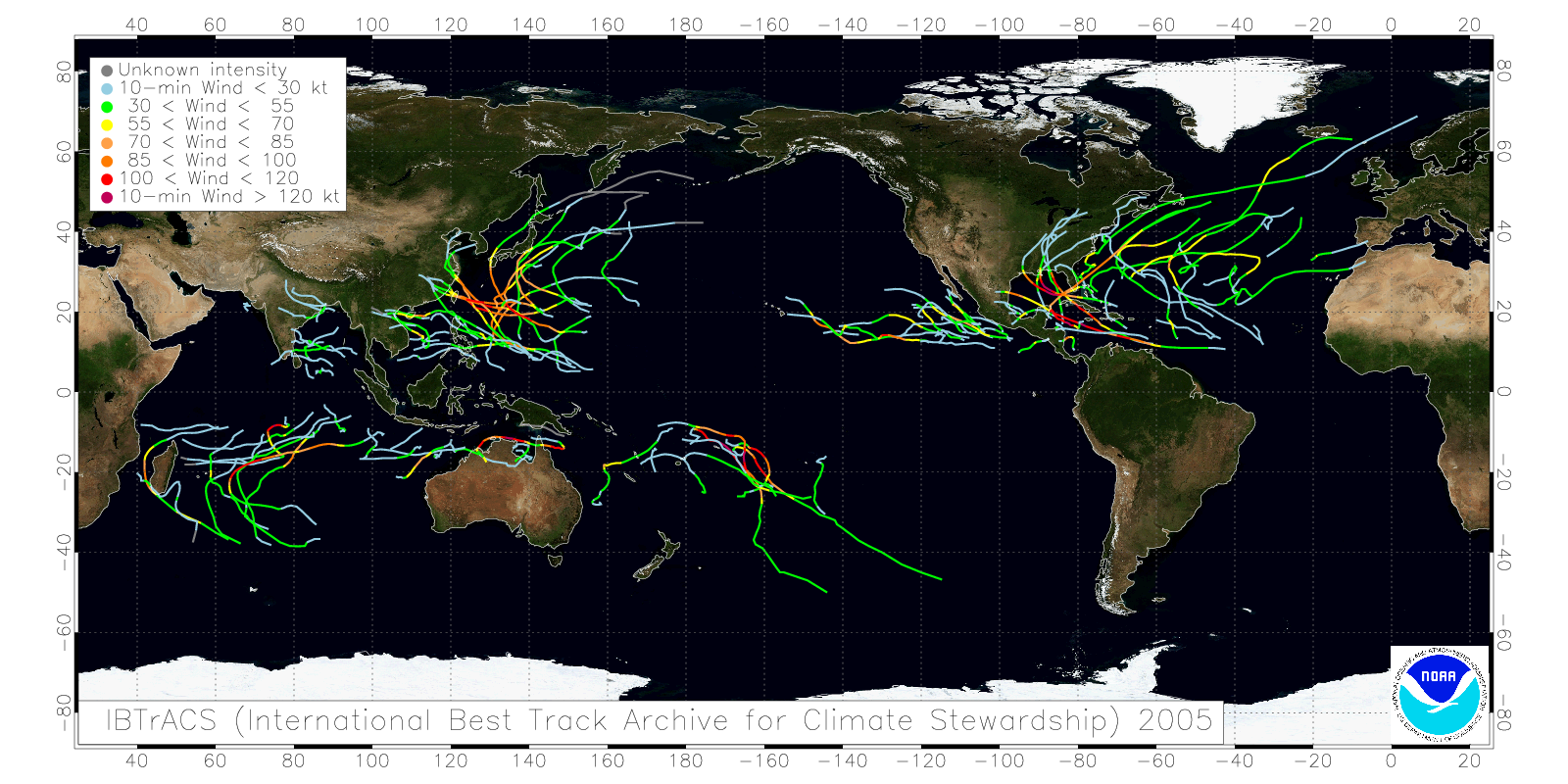
A sample plot of one year of tropical cyclone tracks available in IBTrACS.
The International Best Track Archive for Climate Stewardship (IBTrACS) provides location and intensity for global tropical cyclones. The data span from the 1840s to present, generally providing data at 3-hour intervals. While the best track data is focused on position and intensity (maximum sustained wind speed or minimum central pressure), other parameters are provided by some agencies (e.g., radius of maximum winds, environmental pressure, radius of hurricane force winds, etc.) and are likewise provided in IBTrACS. Files are available subset by Basin or time period, where basins include: East Pacific, North Atlantic, North Indian, South Atlantic, South Indian, South Pacific, and the West Pacific. Time periods include: All data, since 1980, and the last 3 years.
  • Cite as: Knapp, Kenneth R.; Diamond, Howard J.; Kossin, James P.; Kruk, Michael C.; Schreck, Carl J. III (2018). International Best Track Archive for Climate Stewardship (IBTrACS) Project, Version 4. [indicate subset used]. NOAA National Centers for Environmental Information. https://doi.org/10.25921/82ty-9e16 [access date].
  • Please refer to Credit tab for full citation information.
gov.noaa.ncdc:C01552
Order Data
Distribution Formats
  • netCDF-4, Shapefile, CSV (Version: 4)
Ordering Instructions Contact NCEI for other distribution options and instructions.
Distributor NOAA National Centers for Environmental Information
ncei.info@noaa.gov
Dataset Point of Contact Customer Engagement Branch
NOAA National Centers for Environmental Information
1-828-271-4800
ncei.orders@noaa.gov
Time Period 1842-10-25 to Present (time interval: 3-hour)
Spatial Reference System urn:ogc:def:crs:EPSG::4326
Spatial Bounding Box Coordinates
West: -180.0
East: 180.0
South: -90.0
North: 90.0
Spatial Coverage Map
Dataset Information
  • IBTrACS website
    Project website providing access information, background details and links to important resources.
General Documentation
Processing Documents
Associated Resources
Publication Dates
  • publication: 2019-02-15
Edition Version 4
Data Presentation Form mapDigital
Dataset Progress Status Ongoing - data is continually being updated
Data Update Frequency Daily
Purpose Users: reinsurance, forecasters, media, emergency managers, climate monitoring, etc. Use cases: To understand the distribution, frequency and intensity of tropical cyclones. The primary benefit of this dataset is the inclusion of many sources of tropical cyclone data in one place.
Use Limitations
  • The primary limitation is that information is limited to known tropical systems. So those not observed are not recorded (this is much more prevalent prior to satellite observations). Another limitation is that various agencies have different practices when it comes to reporting maximum sustained wind speeds. This makes comparing winds between basins or through time problematic because changes in agencies, personnel or practices can mask underlying climatological shifts (and vice versa).
Dataset Citation
  • Cite as: Knapp, Kenneth R.; Diamond, Howard J.; Kossin, James P.; Kruk, Michael C.; Schreck, Carl J. III (2018). International Best Track Archive for Climate Stewardship (IBTrACS) Project, Version 4. [indicate subset used]. NOAA National Centers for Environmental Information. https://doi.org/10.25921/82ty-9e16 [access date].
  • Users are also asked to cite: Knapp, K. R., M. C. Kruk, D. H. Levinson, H. J. Diamond, and C. J. Neumann, 2010: The International Best Track Archive for Climate Stewardship (IBTrACS): Unifying tropical cyclone best track data. Bulletin of the American Meteorological Society, 91, 363-376. doi:10.1175/2009BAMS2755.1
Cited Authors
  • Kenneth R.
    DOC/NOAA/NESDIS/NCEI > National Centers for Environmental Information, NESDIS, NOAA, U.S. Department of Commerce
  • Howard J.
    DOC/NOAA/NESDIS/NCEI > National Centers for Environmental Information, NESDIS, NOAA, U.S. Department of Commerce
  • James P.
    DOC/NOAA/NESDIS/NCEI > National Centers for Environmental Information, NESDIS, NOAA, U.S. Department of Commerce
  • Michael C.
    DOC/NOAA/NESDIS/NCEI > National Centers for Environmental Information, NESDIS, NOAA, U.S. Department of Commerce
  • Carl J.
    DOC/NOAA/NESDIS/NCEI > National Centers for Environmental Information, NESDIS, NOAA, U.S. Department of Commerce
Principal Investigators
  • Kenneth R.
    DOC/NOAA/NESDIS/NCEI > National Centers for Environmental Information, NESDIS, NOAA, U.S. Department of Commerce
Collaborators
  • Howard J.
    DOC/NOAA/NESDIS/NCEI > National Centers for Environmental Information, NESDIS, NOAA, U.S. Department of Commerce
  • James P.
    DOC/NOAA/NESDIS/NCEI > National Centers for Environmental Information, NESDIS, NOAA, U.S. Department of Commerce
  • Michael C.
    DOC/NOAA/NESDIS/NCEI > National Centers for Environmental Information, NESDIS, NOAA, U.S. Department of Commerce
  • Carl J.
    DOC/NOAA/NESDIS/NCEI > National Centers for Environmental Information, NESDIS, NOAA, U.S. Department of Commerce
Publishers
  • DOC/NOAA/NESDIS/NCEI > National Centers for Environmental Information, NESDIS, NOAA, U.S. Department of Commerce
Theme keywords Global Change Master Directory (GCMD) Science Keywords
  • Earth Science > Human Dimensions > Natural Hazards > Tropical Cyclones > Hurricanes
  • Earth Science > Human Dimensions > Natural Hazards > Tropical Cyclones > Cyclones
  • Earth Science > Human Dimensions > Natural Hazards > Tropical Cyclones > Typhoons
  • Earth Science > Atmosphere > Weather Events > Monsoons
  • Earth Science > Atmosphere > Precipitation > Liquid Precipitation > Rain
  • Earth Science > Atmosphere > Atmospheric Winds > Boundary Layer Winds
  • Earth Science > Atmosphere > Atmospheric Pressure > Anticyclones/Cyclones
  • Earth Science > Atmosphere > Atmospheric Pressure > Sea Level Pressure
  • Earth Science > Atmosphere > Atmospheric Winds > Surface Winds > Wind Speed/Wind Direction
  • Earth Science > Oceans > Coastal Processes > Storm Surge
Global Climate Observing System (GCOS) Essential Climate Variables (ECVs)
  • Atmospheric - Surface - Precipitation
  • Atmospheric - Surface - Wind Speed and Direction
Data Center keywords Global Change Master Directory (GCMD) Data Center Keywords
  • DOC/NOAA/NESDIS/NCEI > National Centers for Environmental Information, NESDIS, NOAA, U.S. Department of Commerce
Platform keywords Global Change Master Directory (GCMD) Platform Keywords
  • Ships
  • Earth Observation Satellites
  • Meteorological Stations
Instrument keywords Global Change Master Directory (GCMD) Instrument Keywords
  • Anemometers
  • Barometers
  • Rain Gauges
Place keywords Global Change Master Directory (GCMD) Location Keywords
  • Geographic Region > Equatorial
  • Geographic Region > Global Ocean
  • Geographic Region > Mid-Latitude
  • Geographic Region > Tropics
  • Ocean > Atlantic Ocean > South Atlantic Ocean
  • Ocean > Atlantic Ocean > North Atlantic Ocean
  • Ocean > Indian Ocean
  • Ocean > Pacific Ocean > Eastern Pacific Ocean
  • Ocean > Pacific Ocean > North Pacific Ocean
  • Ocean > Pacific Ocean > South Pacific Ocean
  • Ocean > Pacific Ocean > Western Pacific Ocean
Data Resolution keywords Global Change Master Directory (GCMD) Horizontal Data Resolution Keywords
  • Point Resolution
Global Change Master Directory (GCMD) Vertical Data Resolution Keywords
  • Point Resolution
Global Change Master Directory (GCMD) Temporal Data Resolution Keywords
  • Hourly - < Daily
Stratum keywords Global Change Master Directory (GCMD) Location Keywords
  • Vertical Location > Sea Surface
  • Vertical Location > Land Surface
Use Constraints
  • Cite as: Knapp, Kenneth R.; Diamond, Howard J.; Kossin, James P.; Kruk, Michael C.; Schreck, Carl J. III (2018). International Best Track Archive for Climate Stewardship (IBTrACS) Project, Version 4. [indicate subset used]. NOAA National Centers for Environmental Information. https://doi.org/10.25921/82ty-9e16 [access date].
  • Users are also asked to cite: Knapp, K. R., M. C. Kruk, D. H. Levinson, H. J. Diamond, and C. J. Neumann, 2010: The International Best Track Archive for Climate Stewardship (IBTrACS): Unifying tropical cyclone best track data. Bulletin of the American Meteorological Society, 91, 363-376. doi:10.1175/2009BAMS2755.1
  • Use liability: NOAA and NCEI cannot provide any warranty as to the accuracy, reliability, or completeness of furnished data. Users assume responsibility to determine the usability of these data. The user is responsible for the results of any application of this data for other than its intended purpose.
Access Constraints
  • Distribution liability: NOAA and NCEI make no warranty, expressed or implied, regarding these data, nor does the fact of distribution constitute such a warranty. NOAA and NCEI cannot assume liability for any damages caused by any errors or omissions in these data. If appropriate, NCEI can only certify that the data it distributes are an authentic copy of the records that were accepted for inclusion in the NCEI archives.
Fees
  • In most cases, electronic downloads of the data are free. However, fees may apply for custom orders, data certifications, copies of analog materials, and data distribution on physical media.
Lineage information for: dataset
Lineage Statement Prior to receiving the data at NCEI, there is some uncertainty in the lineage as data processing practices at some agencies are better documented than others. The data are produced from real time (during the season) and post-season analysis of TC observations. Thus, there is some uncertainty on what observations were available at a given agency, what practices were in place that might affect intensity estimates and what practices and procedural thresholds were used to track some systems but not others.
Processor
  • DOC/NOAA/NESDIS/NCEI > National Centers for Environmental Information, NESDIS, NOAA, U.S. Department of Commerce
  • DOC/NOAA/NESDIS/NCEI > National Centers for Environmental Information, NESDIS, NOAA, U.S. Department of Commerce
  • DOC/NOAA/NESDIS/NCEI > National Centers for Environmental Information, NESDIS, NOAA, U.S. Department of Commerce
Processing Steps
  • Reformat source data to netCDF
    Rationale: This step reformats all best track files into a uniform netCDF dataset structure. This simplifies further processing.
  • Identify similar storms and merge data.
    Rationale: The agencies each have different practices for storm identification. Thus, it takes some analysis to determine which tracks from one agency correspond tracks in another.
  • Produce track data for individual storms
    Rationale: Once storms as identified as potentially the same, then analysis is performed to define tracks and output all data into intermediate netCDF files.
  • Reformat track data by basin and date.
    Rationale: Many customers need on subsets of IBTrACS. Tracks are split by basin (e.g., North Atlantic, Eastern Pacific, Western Pacific, North Indian, South Indian and South Pacific) or by time period (all years, ears since 1980 or last 3 years). The result are file sets in 3 formats: CSV, shapefile and netCDF.
Processing Environment The processing environment is a Linux server running BASH. Many of the modules use IDL but one process requires perl. Many of the intermediate and final files are netCDF. See documentation for more information.
Processing Documents
Source Datasets
  • Cyclone data from RSMC Tokyo (JMA)
  • Cyclone data from Hong Kong Observatory
    • Description of Source: HKO best tracks data. Data are not available online. The BT file is usually emailed to NCEI upon request.
  • Cyclone data from RSMC New Delhi (IMD)
    • Cyclone data from RSMC New Delhi (IMD)
      Data is provided in an Excel spreadsheet. Spreadsheet is converted to CSV file for ingest into the IBTrACS dataset.
    • Description of Source: IMD best track data
  • Cyclone data from Cyclone data from RSMC La Reunion (MeteoFrance)
    • Description of Source: La Reunion best track data. No public URL is available. Data are emailed to NCEI when requested.
  • Bureau of Meteorology (Australia)
    • Bureau of Meteorology (Australia)
      The database at this URL is updated frequently and will often contain operational (i.e., not reanalyzed or best track-ed) data for recent storms.
    • Description of Source: BoM best track data
  • Cyclone data from Cyclone data from RSMC Nadi (Fiji). No publicly accessible URL. This data is emailed to NCEI (Howard Diamond or Ken Knapp) when requested.
    • Description of Source: RSMC Nadi Best Track data
  • Cyclone data from TCWC Wellington (New Zealand)
    • Description of Source: TCWC Wellington best track data. No publicly accessible URL. This data is emailed to NCEI (Howard Diamond or Ken Knapp) when requested.
  • Reformatted BestTrack data
    • Description of Source: This step uses reformatted best track data from the previous step (converting raw data to standardized Best Track data).
  • Merged Best Track data
    • Description of Source: This step is completed using data from the previous "merge" step along with the reformatted original BT data.
Lineage information for: repository
Processing Steps
  • 2015-04-22T00:00:00 - NOAA created the National Centers for Environmental Information (NCEI) by merging NOAA's National Climatic Data Center (NCDC), National Geophysical Data Center (NGDC), and National Oceanographic Data Center (NODC), including the National Coastal Data Development Center (NCDDC), per the Consolidated and Further Continuing Appropriations Act, 2015, Public Law 113-235. NCEI launched publicly on April 22, 2015.
Last Modified: 2023-07-06
For questions about the information on this page, please email: ncei.info@noaa.gov