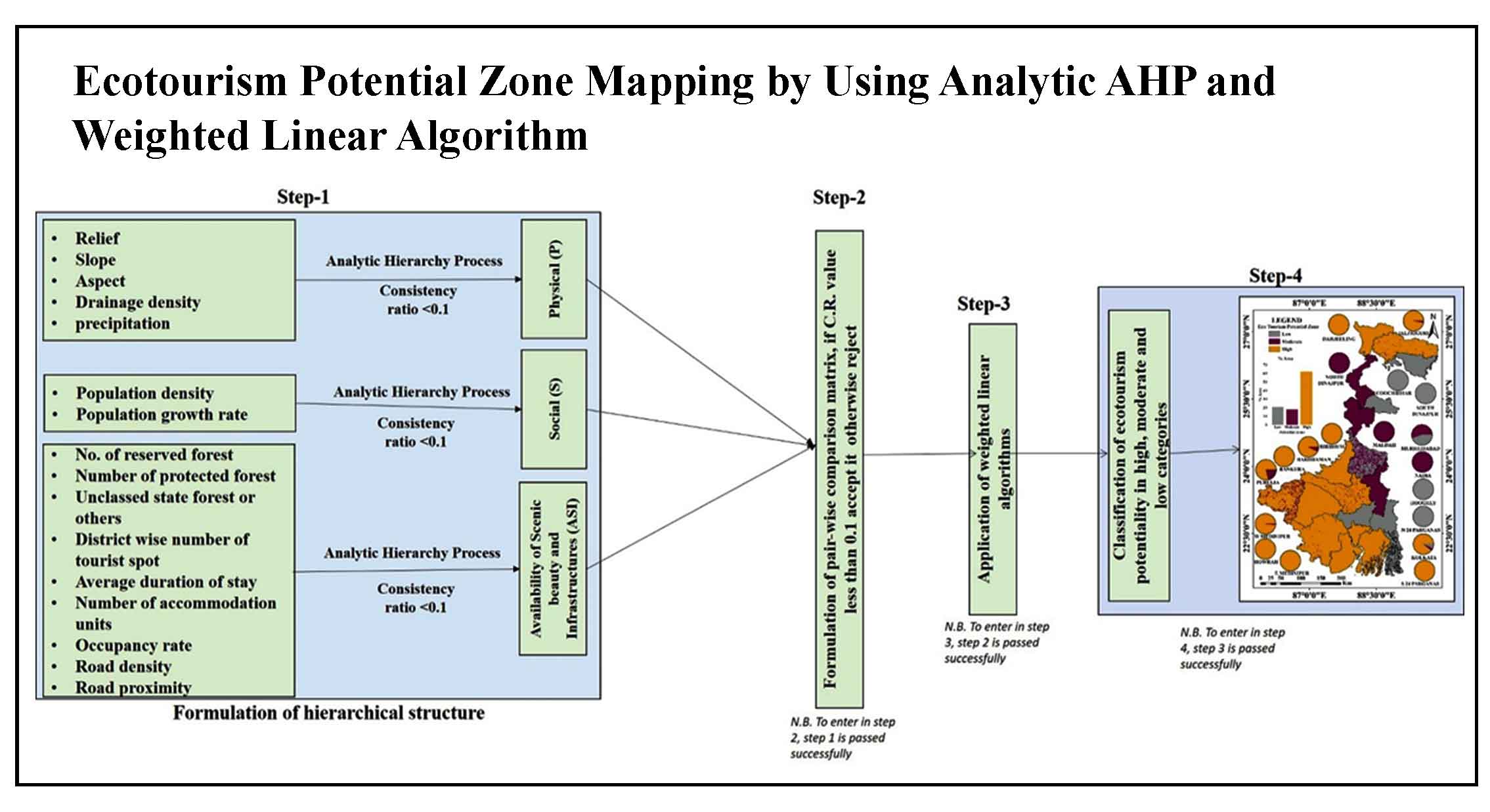
Article Title :
Quality Assessment of Globally Available Digital Elevation Model (DEM) for Mountainous Region
5 (2021)
11-21
ALOS PALSAR , ASTER GDEM , Normalized Cross Correlation , Root Mean Square Error , SRTM


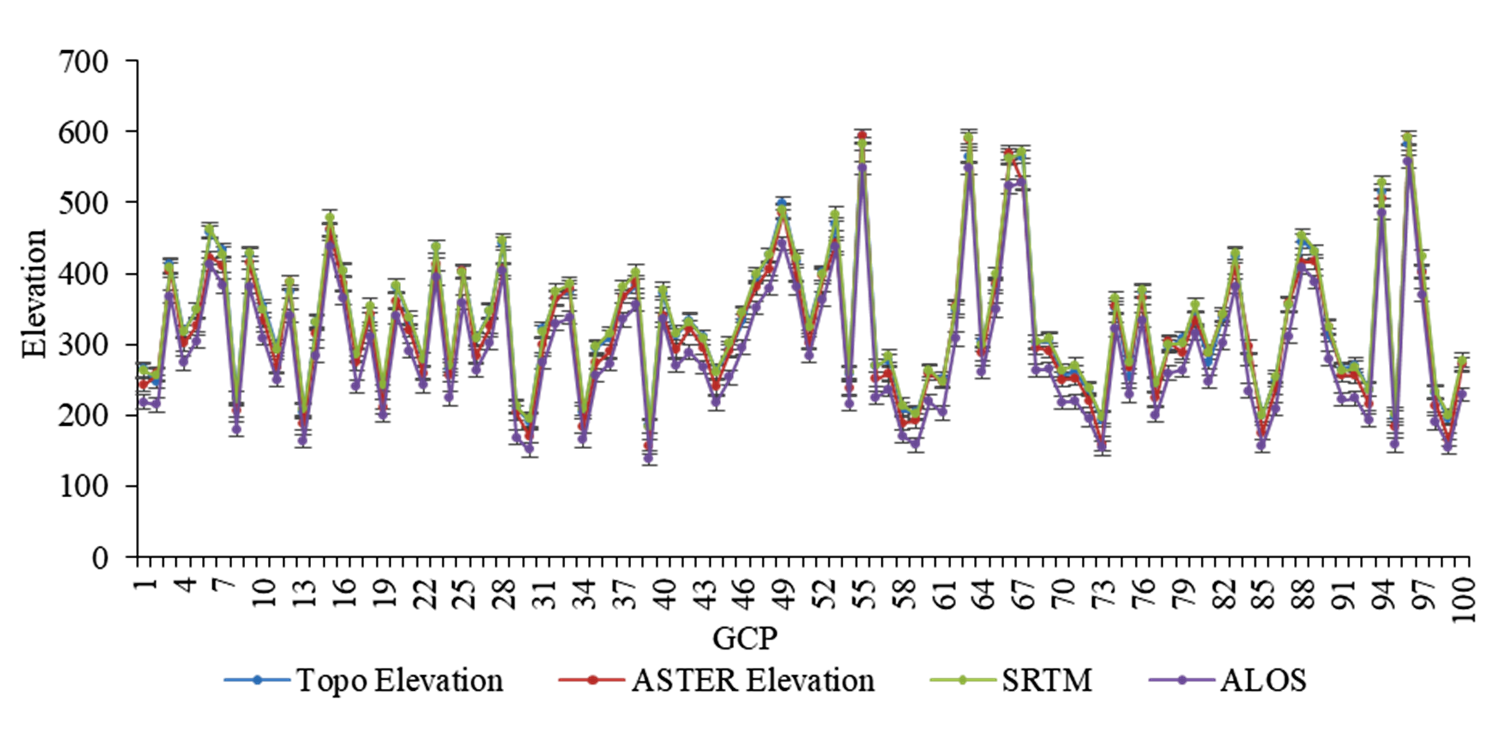
The study assessed the accuracies of globally available Digital Elevation Models (DEM’s) i.e., SRTM v3, ASTER GDEM v2 and ALOS PALSAR DEM with respect to Topo-DEM derived from topographic map of 5m contour interval. 100 ground control points of the elevation data were collected with the help of kinematic hand held GNSS (Global Navigation Satellite System), randomly distributed over the study area. The widely used RMSE statistic, NCC correlation and sub-pixel-based approach were applied to evaluate the erroneous, correlation, horizontal and vertical displacement in terms of pixels for the individual Digital Elevation Model. Following these evaluations, SRTM DEM was found to be highly accurate in terms of RMSE and displacement compared to other DEMs. This study is intended to provide the researchers, GIS specialists and the government agencies dealing with remote sensing and GIS, a basic clue on accuracy of the DEMs so that the best model can be selected for application on various purposes of the similar region.
The topographic representation in the form of Triangulated Irregular network (TIN), spot height (x,y,z) and isoline representing the earth surface is called Digital Elevation Model (DEM).
The 30 m Shuttle Radar Topography Mission (SRTM) DEM v3 is better in such kind of area covered with relief, sparsely vegetated coverage and mixed with flood plain geomorphic features.
The mis-registration are the common limitation observed in all the DEMs, which may be due to the process involved in interpolation, conversion and data manipulation in creating DEMs and its derivations.
The Root Mean Square Error (RMSE) of ASTER GDEM v2 was observed with 17.4 m with horizontal shift of 8.52 m toward east and 9.06 m vertically toward north direction.
ALOS PALSAR DEM showed RMSE 40.30m with negligible shift in horizontal and vertical direction but the pixel displacement of 5 pixels toward east and 10 pixels toward north from the reference Topo DEM.
Baldi, P., Bonvalot, S., Briole, P., Coltelli, M., Gwinner, K., Marsella, M., Puglisi. D., G. and Remy, D., 2010. Validation and comparison of different techniques for the derivation of digital elevation models and volcanic monitoring (Vulcano Island, Italy). International Journal of Remote Sensing, 23(22), 4783-4800.
Yan, S., Guo, H., Liu, G. and Ruan, Z., 2013. Mountain glacier displacement estimation using a DEM-assisted offset tracking method with ALOS/PALSAR data. Remote Sensing Letters, 4(5), 494-503
Yap, L., Houetchak Kande, L., Nouayou, R., Kamguia, J., Abdiu Ngouh, N. and Makuate, M. B., 2018. Vertical accuracy evaluation of freely available latest highresolution (30 m) global digital elevation models over Cameroon (Central Africa) with GPS/leveling ground control points. International Journal of Digital Earth, 12(5), 500-524.