


Located in the south-east of Poland, the Sandomierz Upland is one of the most important settlement regions north of the Carpathian Mountains for research on the character and dynamics of cultural transformation in the Neolithic. This statement particularly applies to the early phase of the Neolithic (the second half of the sixth to the end of the fifth millennium BC), which is linked with the presence of Danubian communities associated with the Linearbandkeramik (LBK), Lengyel and Malice Cultures. Several hundred sites dated to this period are now known from this mesoregion, and these are concentrated in its central and eastern zones (Kowalewska-Marszałek Reference Kowalewska-Marszałek, Wolfram and Stäuble2012). The northern part of the region encompasses the edge of the loess plateau and its sandy-clay foreland, which is part of the Iłża Foothills (Figure 1). Until recently, only single surface finds were known from this northern area, and none of these were diagnostically useful. The dearth of evidence suggested that the permanent settlements of early agrarian societies were limited to the loess cover of the Sandomierz Upland, and that its northern periphery had been at most only occasionally occupied. This pattern echoed those seen elsewhere, reflecting the apparent settlement preferences of Danubian communities in Central Europe, including the Upper Vistula Basin (Czekaj-Zastawny Reference Czekaj-Zastawny2008).
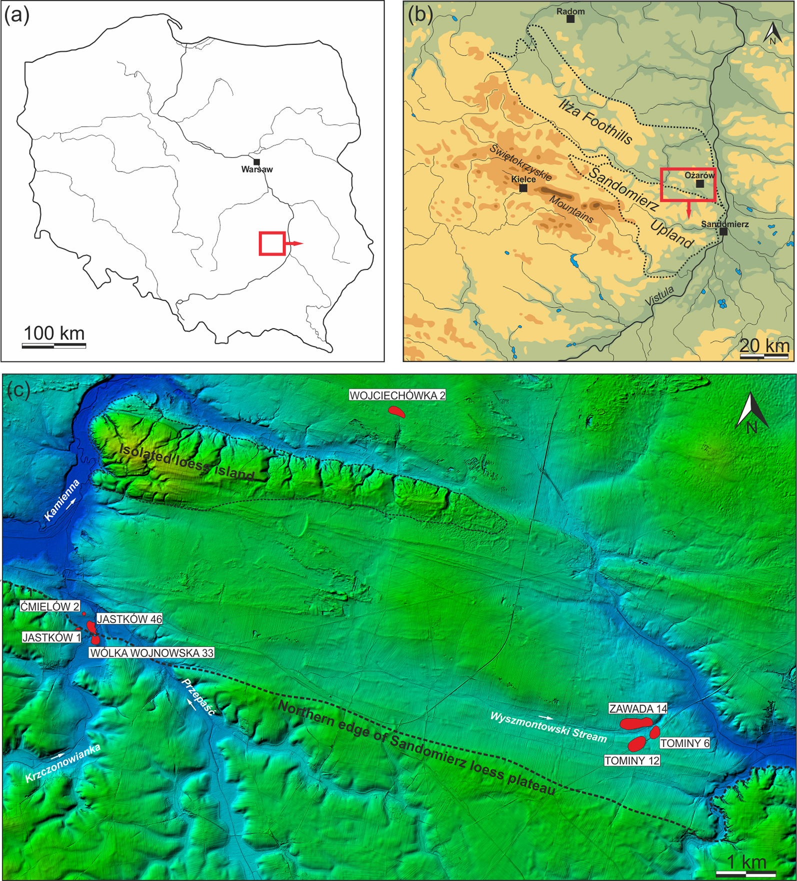
Figure 1. Study area (a–c) showing the locations of sites (drawing by M. Szeliga; c) prepared by M. Szeliga, based on lidar data).
This theory was tested by excavations at three sites located outside the edge of the loess upland, within the sandy-clay area of the southern part of the Iłża Foothills; these were Ćmielów 2 (Michalak-Ścibior Reference Michalak-Ścibior1994), Tominy 6 and Tominy 12 (Kadrow & Olejarczyk Reference Kadrow, Olejarczyk and Kośko2010; Szeliga Reference Szeliga2017) (Figure 1). The results of these excavations confirmed that permanent, vast LBK and Malice Culture settlements had existed in this area, which is an atypical ecological landscape for such communities. These discoveries became the principal reason for undertaking research focused on estimating the character, range and intensity of settlement and economy of Danubian communities, as well as reconstructing environmental conditions and the impact of these activities in the northern part of the Sandomierz Upland.
The project (‘A Colonization of Peripheral Areas of Loess Uplands by Early Agricultural Communities (the Second Half of the Sixth to the End of the Fifth Millennium BC) on the Example of the Northern Foreland of the Sandomierz Upland’), launched in 2016, is comprised of two essential parts. The first focuses on multiple interdisciplinary analyses of artefacts and samples obtained during previous excavations at Tominy 6. These analyses include: traceology, electron microscopy (SEM-EDS), spectroscopy and neutron methods (ED-XRF, GC-MS, PGAA), as well as radiocarbon and thermoluminescence dating. The second part includes targeted field research. The aim of this fieldwork is to obtain new archaeological and environmental data, allowing a reconstruction of the local settlement conditions, as well as the degree of anthropopressure in the sixth to fifth millennia BC. Excavations were conducted at six sites in the border area between the Sandomierz Upland and Iłża Foothills: Jastków 1 and 46; Tominy 6; Wojciechówka 2; Wólka Wojnowska 33 and Zawada 14 (Figure 1).
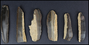
The research at Tominy 6 was a continuation of excavations undertaken between 2006 and 2015. Over a hectare was excavated, revealing the remains of a vast settlement from the classical and late phases of the LBK (Figure 2a–d), which existed between at least 5100 and 4900/4800 BC (Szeliga Reference Szeliga2017). The abundance and nature of flint artefacts confirm the nature of the settlement as a site connected with the production and processing of the local Turonian flints. Numerous obsidian items were discovered together with examples of the Kapušany-Tiszadob group of the Alföld-LBK pottery (genuine imports and local ware that copied it) and Bükk Culture ceramics (Figure 2e); these indicate extensive relations with the northern part of the Carpathian Basin. The results of archaeobotanical and zooarchaeological analyses attest to an agricultural economy based mainly on growing wheat and cattle husbandry. The high percentage of wild animal remains, however (Figure 2f), indicates the importance of hunting for the local communities.
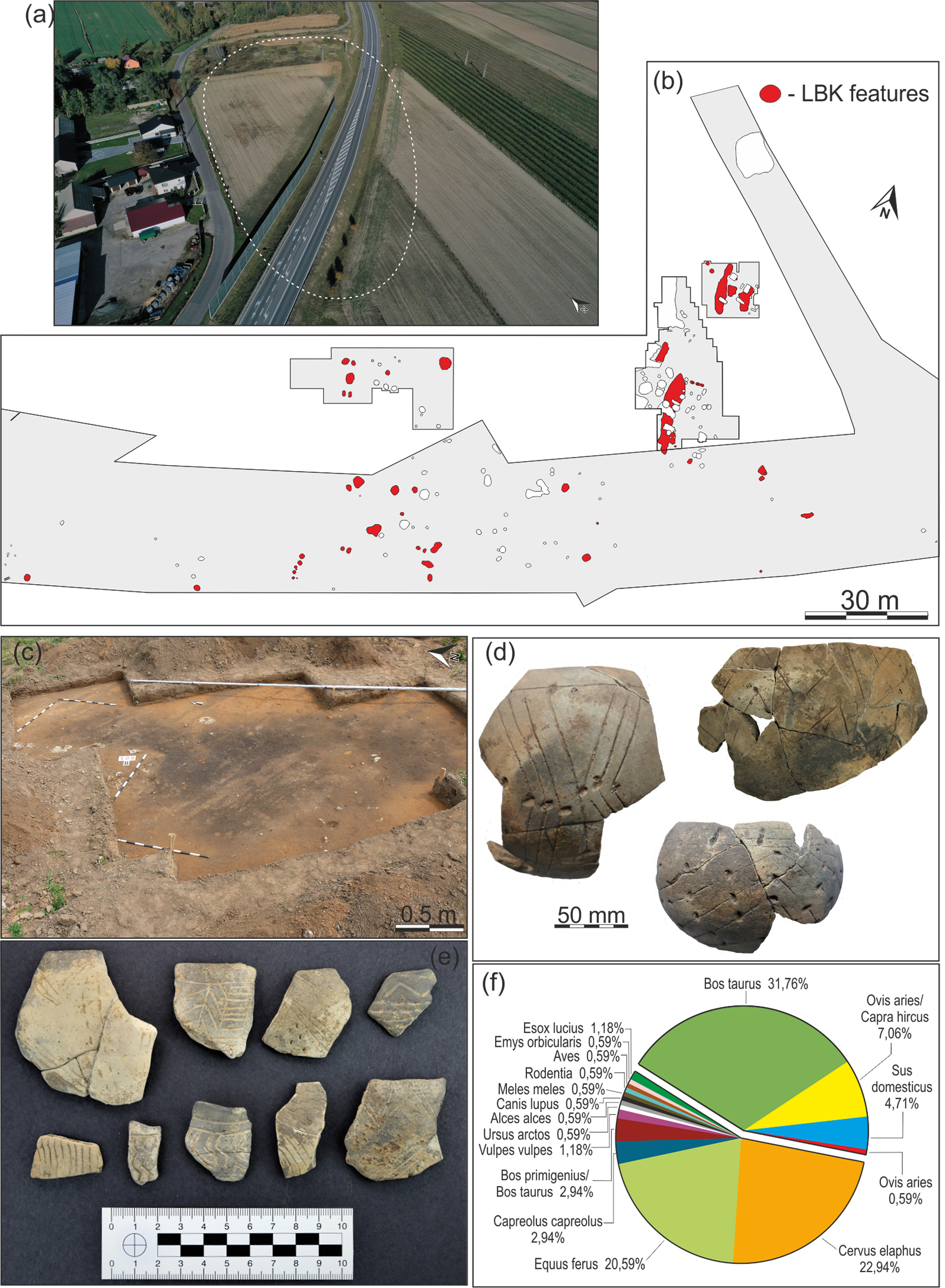
Figure 2. Tominy 6: a) aerial view of the site; b) plan showing Linearbandkeramik (LBK) features; c) excavated area; d) LBK ceramics from the site; e) Kapušany-Tiszadob group of the Alföld-LBK/Bükk Culture ceramics; f) chart showing percentages of faunal remains; (a–e) photographs and drawings by M. Szeliga; f) drawing by D. Makowiecki).
Zawada 14 is located near the settlement at Tominy, occupying the southern slope of a low promontory (Figure 3a). The excavations in 2017 concentrated on verifying selected magnetic anomalies (Figure 3b). In one of the trenches, an elongated pit of oval shape was found containing rich pottery and flint assemblages (Figure 3c–e). The ornamentation and technological features of the pottery make it possible to associate the complex with the late classical phase of the Malice Culture, dated to the second half of the fifth millennium BC.
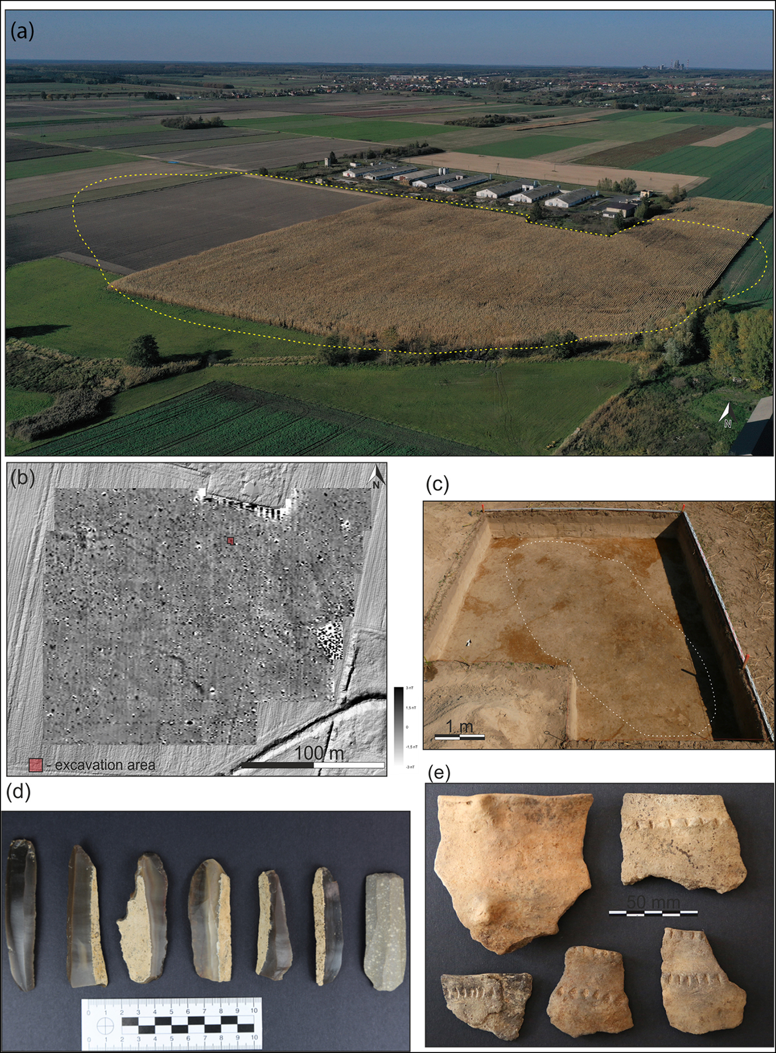
Figure 3. Zawada 14: a) aerial view; b) geophysical anomaly plot; c) excavated area; d) flint assemblage; e) ceramic small finds; (a, c–e) photographs by M. Szeliga; b) prepared by M. Furmanek).
Wojciechówka 2 is the most northerly, as well as the least accessible, of the analysed sites (Figure 4a). Research between 2017 and 2019 did not yield conclusive evidence that the site had been used or settled by Danubian societies. The morphometric properties of flint artefacts from the site, however, allow us to propose that it is very likely to have been settled by these communities (Figure 4b–c).
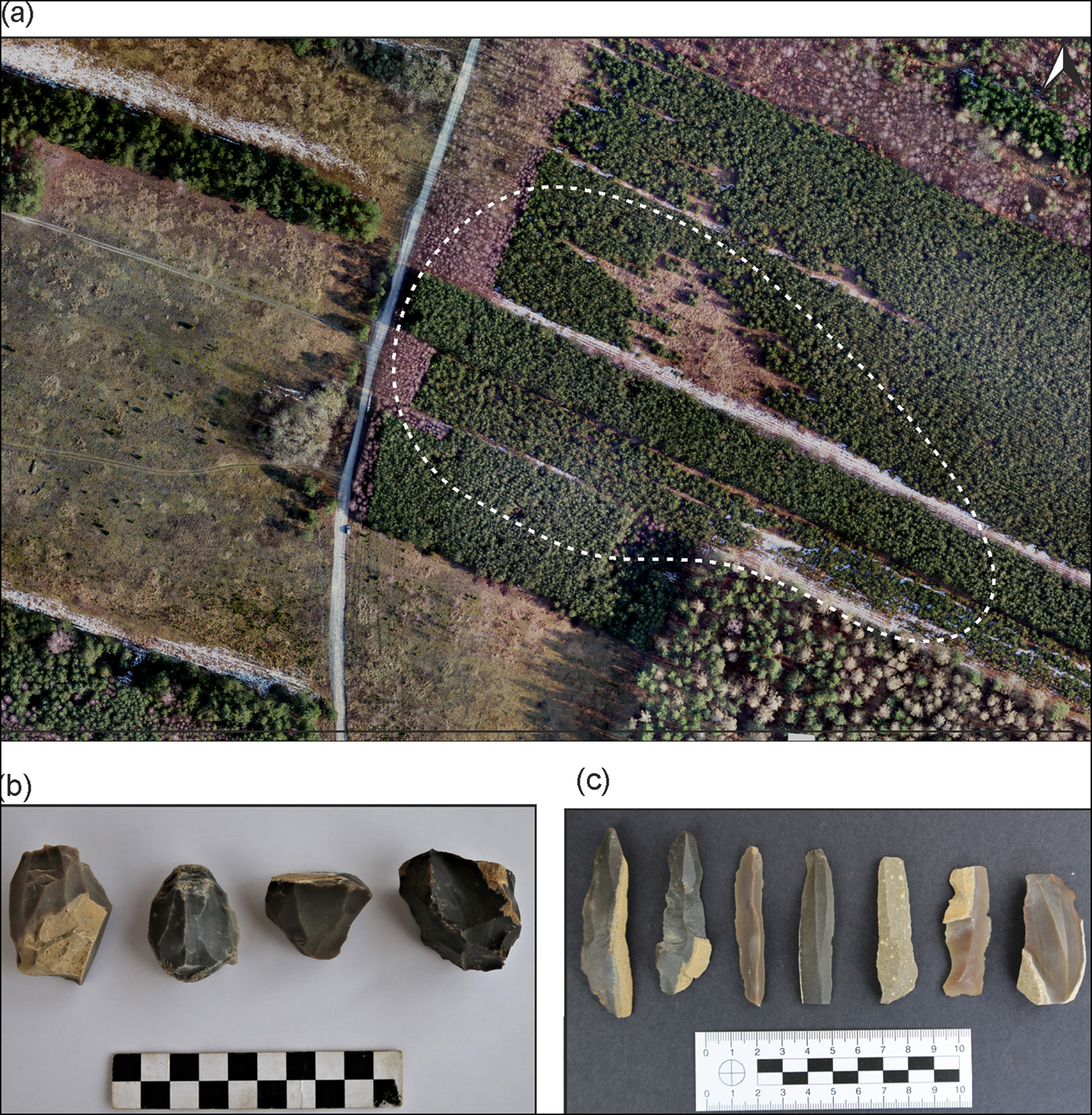
Figure 4. Wojciechówka 2: a) aerial view of the site; b–c) flint assemblage; (a) photograph by P. Bartmiński; b–c) photographs by M. Szeliga).
Wólka Wojnowska 33, Jastków 1 and 46 are located in the western part of the study area, concentrated near the lower Krzczonowianka stream (Figure 5a). Wólka Wojnowska 33 has seen limited fieldwork, but the materials recovered from the site confirm the settlement of both LBK and Malice Culture communities. The most valuable data were obtained from Jastków 1 and 46, where geomagnetic surveys revealed numerous anomalies of considerable dimensions; these were elongated shapes oriented parallel, or nearly parallel, to the north–south axis of structures at the site. The results of excavations in 2018 and 2019 confirm the interpretation of these features as the remains of construction pits associated with at least 21 longhouses (Figure 5b–c). The finds assemblages from Wólka Wojnowska 33 and Jastków suggest that the settlements date to the classical and late phases of the LBK. Fragments of pottery discovered outside the features confirm the subsequent presence of a Malice Culture community at all three sites.
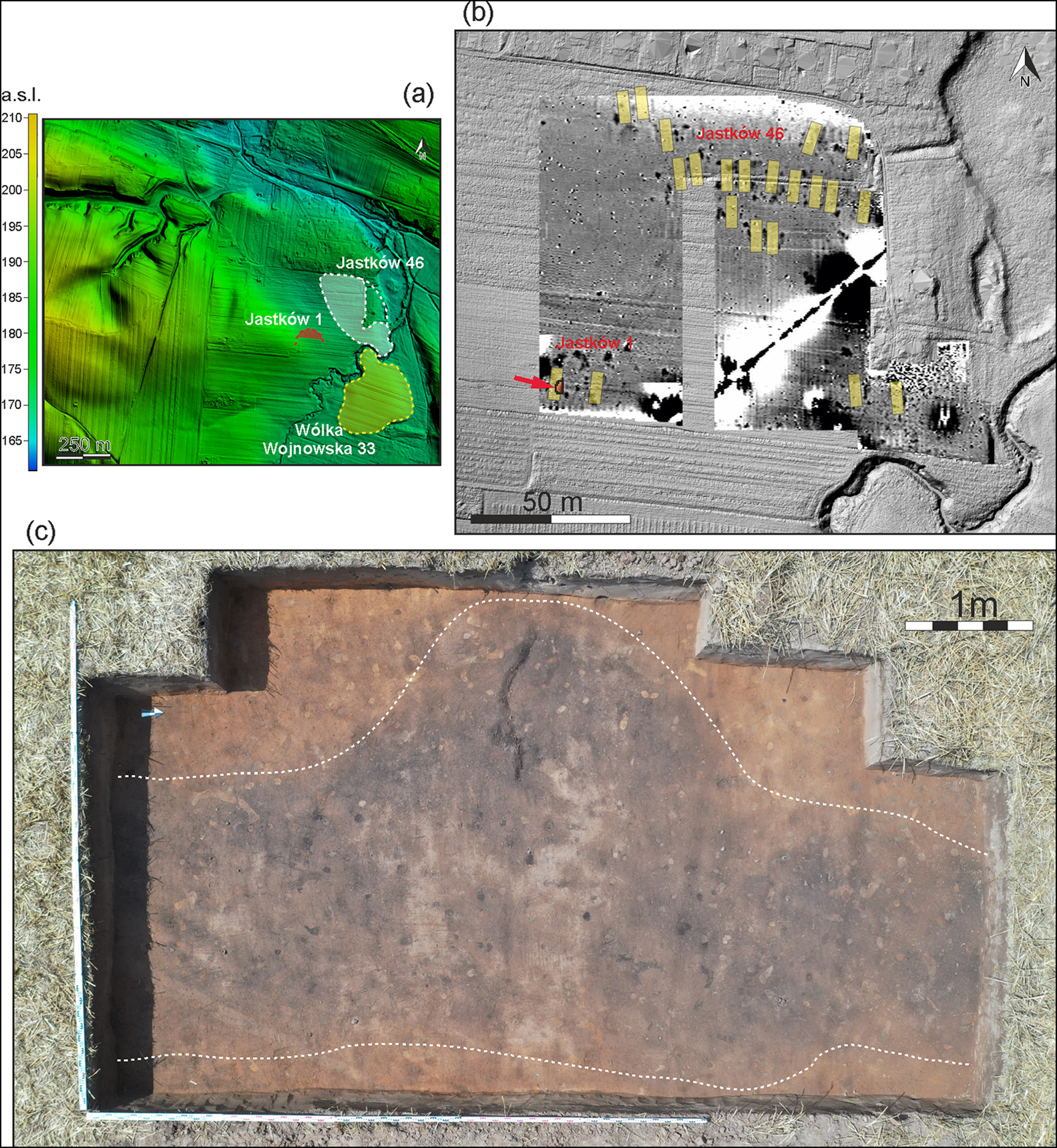
Figure 5. a) Digital terrain model showing the locations of Wólka Wojnowska 33, Jastków 1 and 46; b) geophysical anomaly plot of the Jastków 1 and 46 sites; c) excavated area at Jastków 1; (a & c) prepared and photographed by M. Szeliga; b) prepared by M. Furmanek).
The results of fieldwork and post-excavation analyses confirm that the northern periphery of the Sandomierz Upland was intensely colonised in the sixth and fifth millennia BC. They also attest to early agricultural colonisation of upland areas, located on the edge of loess formations and especially outside their compact range, that are still poorly understood. This reveals the remarkable skills of local LBK and Malice Culture communities in adapting to different environmental conditions. The data make it possible to extrapolate that analogous settlement clusters existed in other marginal regions of the Central European loess belt, constituting an important area for further research.
Acknowledgements
The project is financed by the National Science Centre, Poland (grant: 2015/19/B/HS3/01720).


 Open access