Walking the Edge of the Earth
By Leila Christine Nadir
Eve Mosher’s art project HighWaterLine takes climate science to the streets.
Eve Mosher’s art project HighWaterLine takes climate science to the streets.

DOI: 10.1511/2015.113.110
In 2007, environmental artist Eve Mosher read a report by Vivien Gornitz of Columbia University’s Center for Climate Systems Research and learned that parts of her home city of New York are increasingly likely to be inundated by seawater in coming decades. According to the report, areas along New York’s coast will experience what scientists call a “100-year flood” much more frequently than the name suggests. As climate change accelerates, these neighborhoods can expect 100-year floods every 40 years by the 2020s, every 20 years by the 2050s, and every 4 years by the 2080s.
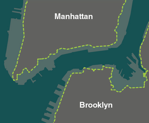
Illustration by Tom Dunne.
Mosher wanted to know what these numbers mean for the people and places closest to her. What exactly is in the flood zone? What will be the impact of warming oceans and melting glaciers for specific communities? Frustrated that the report did not answer her questions, and worried about the absence of climate change from public debate, she decided to find a way to make the data feel more real. She wanted to connect climate science with the places where we live, work, and play.
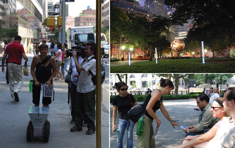
For Mosher, art provides the crucial link: “Artists can create visceral and emotional connections that can make change possible in ways that data and reports cannot,” she says. In summer 2007, she set out on foot, equipped only with blue chalk and a chalk dispenser called a “Heavy Hitter,” and drew a line marking an elevation of 10 feet above sea level—the elevation of the 100-year floodplain—through more than 70 miles of Manhattan’s and Brooklyn’s waterfronts.
Mosher’s blue line wove through the neighborhoods of Chinatown, Coney Island, Tribeca, Dumbo, the East Village, and beyond. It outlined schools, churches, and hospitals. It wound around playgrounds and apartment buildings. Her public art performance, titled HighWaterLine, drew crowds of art lovers, activists concerned about climate change, and curious bystanders wherever she went. The project gave tangible meaning to the climate data, prying them free from academic reports and embedding them directly into the landscape.
Taking a walk to think and to learn is a common ritual in the Western philosophical tradition. In her cultural history of walking, Wanderlust, author Rebecca Solnit traces centuries of writers’ accounts describing how an outdoor stroll clears the mind, reshapes perceptions, and triggers intellectual epiphanies. Our feet seem to ground our imaginations, clarifying and solidifying new ideas. In recent decades, artists such as Hamish Fulton and Richard Long have approached walking as their primary medium, documenting their insights and interactions along their treks and leaving behind traces of their journey. Solnit writes about the artistic aspect of such performances: “One person’s act can be an invitation to another’s imagination; the way every gesture can be imagined as a brief and invisible sculpture, the way walking reshapes the world by mapping it, treading paths into it, encountering it; the way each act reflects and reinvents the culture in which it takes place.”
Photograph courtesy of Eve Mosher.
Likewise, Mosher’s HighWaterLine—both her journey through New York City and the trace of blue chalk she left behind—invites residents and passersby to reimagine the places they inhabit and to rethink the relationship of climate to culture. As Mosher walked, discovering exactly which areas would be flooded by seawater and storm surges, she snapped photos and documented her route online. (Readers can follow her journey on the HighWaterLine NYC website.) She also fielded questions from the public, handing out flyers when asked for more information. Such welcoming of unpredictable social encounters is a common feature of conceptual art. Mosher’s intention, she says, was “to set up a space for dialogue about how climate change affects us as individuals and as communities”—precisely what is so often missing from media and scientific reports.
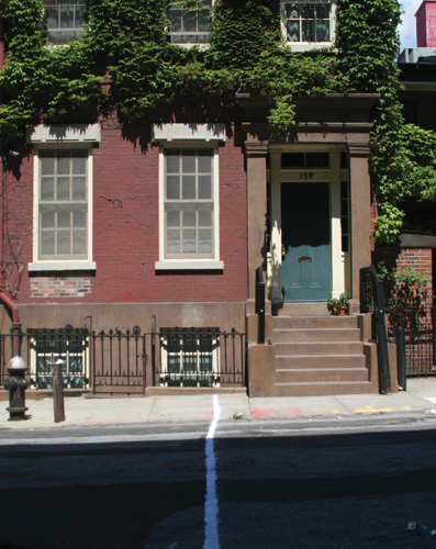
Some of the people experiencing HighWaterLine were inspired to share stories about bizarre weather patterns, such as the tornado that had whipped through Brooklyn earlier that summer. Visitors and immigrants to New York talked about the climate politics in their home countries and about the discussions taking place or not taking place within their governments. A few homeowners disclosed that they’d recently been denied flood insurance without explanation; the blue line snaking down their streets suddenly helped them understand why. “Walking through places and neighborhoods,” Mosher says, “you get a very different understanding of climate change.”
That understanding is why Mosher was not shocked when, in 2012, Superstorm Sandy flooded New York City’s waterfront and cost the metropolitan area more than $42 billion. Five years earlier, HighWaterLine had forecast the dimensions of Sandy’s storm surge with frightening accuracy. Two days after the surge, Mosher wrote on her blog, “I have seen images of water up to (and past, in many cases) where I drew the line. I keep hearing about incidents that, sadly, don’t surprise me at all.”
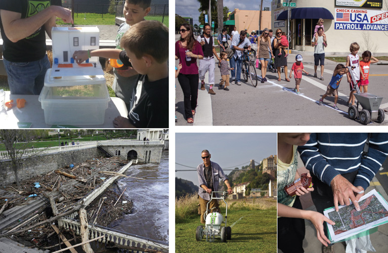
After performing HighWaterLine in New York City, Mosher received invitations to replicate the project in other locales, but the prospect of traveling to cities she didn’t live in, researching, mapping, and walking the flood zones, and then leaving the community behind didn’t make sense to her. “There would be all this momentum, all this work to raise awareness, but no embedded process of working toward change,” she said. Instead of continuing as a solo artist–driven performance, HighWaterLine evolved into more of a community-based project through collaboration with Heidi Quante, director of the San Francisco–based nonprofit agency Creative Catalyst. Quante proposed a grassroots redesign of HighWaterLine for two other cities known to be seriously vulnerable to sea level rises: Miami and the English port city of Bristol.
Quante’s vision for HighWaterLine called for interactive workshops that unfolded over months, with local citizens conducting their own research, mapping the elevation of their neighborhoods, and learning which areas, buildings, homes, institutions, and local cultures would be destroyed by rising water. Students, housing rights activists, environmentalists, and local residents collaborated to trace the blue chalk line on streets and sidewalks they already knew intimately. They developed organizing skills and emergency preparedness plans for their communities. Together, they transformed data into experience, and the knowledge they gained stayed home, where it was needed most. “Scientists provide the data, and art brings it to life,” Quante says. “The community members are the experts of their own neighborhoods. This method of working breaks down the impasses and accelerates action and solutions.”
Images courtesy of Eve Mosher; images at left and bottom right by Hose Cedeno.
Quante regards art as a catalyst for behavioral change, including learning on one’s “daily migratory path.” Studies show that education is most effective when we encounter something new within a familiar setting. As neurobiologists Daniela Schenker and Hartmut Schütze wrote in a recent Scientific American article, “Learning by Surprise,” this kind of combined experience stimulates the hippocampus, sometimes called the brain’s novelty detector. A moment of novelty that occurs where we are most at home can generate thought-provoking surprise, a displacement, that can renew our consciousness of surroundings we normally take for granted. In her cultural history of walking, Solnit gives a similar account of a walk’s effects on the mind: “The random, the unscreened, allows you to find what you don’t know you are looking for, and you don’t know a place until it surprises you.”
Unexpected realizations on a stroll are often pleasant, mind-expanding experiences, chances to get to know your environment better. But in the case of climate change, the experience can be downright disturbing—even for experts acquainted with the data. Marta Viciedo, a Miami resident with a master’s degree in urban planning who had studied sea level rise as a research fellow at Florida Atlantic University’s Visual Planning and Technology Lab, nevertheless considered her involvement in HighWaterLine|Miami to be a wake-up call:
Until my participation with HighWaterLine, I had not fully internalized what it meant for South Florida to be considered “Ground Zero” for climate change. Sea level rise was something I studied, or more specifically assisted in researching, but the intricacies of how a rising tide, potentially within my lifetime, could overcome much of the island I spent my summers on with my grandmother (Miami Beach) had never fully cemented itself in my head. Ditto for the city of Miami, where I now live with my own children. Researching, discussing, mapping, or even rendering possible scenarios resonates quite differently than standing on the street corner you have walked past hundreds of times and visualizing what it would be like to do so in water that is knee deep ALL. THE. TIME.
It is difficult to make a definitive statement about the impact of HighWaterLine because, like all good art, it does not have just a single meaning. It invests climate data with local stories and real lives. It creates a platform for new dialogues. And it is an effective organizing tool. Two community-based groups that participated in the Miami workshops, Resilient Miami and Catalyst Miami, were awarded a planning grant from the Kresge Foundation to help their neighborhoods become more resilient against major storms. In the United Kingdom, HighWaterLine|Bristol received a grant from the Environment Agency to share best practices and create a community guide for coping with rising sea levels.
Top photographs courtesy of Eve Mosher; bottom left courtesy of Fairmont Water Works; bottom middle courtesy of Richard Clutterbuck; bottom right courtesy of HighWaterLine and Pete Bedwell.
At the same time, HighWaterLine is also a historical document of a moment of impending change. When Mosher originally performed the project in 2007, there was plenty of time when she walked silently, and nobody stopped her to ask what she was doing. In those moments, she was the only witness to her project, an experience she is still pondering: “What does it mean for me to have bodily walked 70 miles of vulnerable coastal area, passing through these spaces with the knowledge I have, and as I walked, taking in more knowledge, recognizing, witnessing? I didn’t do in-depth studies of coastline, but I know where the horse stables are in Coney Island. I know about the landfill that is in South Brooklyn. I know the families that play on the Red Hook soccer field.”
HighWaterLine is an invitation to understand, to act, and to prepare. But if political solutions to climate change don’t materialize soon, it may also be an invitation to come to terms with loss.
Click "American Scientist" to access home page

American Scientist Comments and Discussion
To discuss our articles or comment on them, please share them and tag American Scientist on social media platforms. Here are links to our profiles on Twitter, Facebook, and LinkedIn.
If we re-share your post, we will moderate comments/discussion following our comments policy.