

Abstract
Despite the ongoing impacts of climate change around the world, fossil fuels continue to drive the global economy. The socio-environmental impacts of oil development at the local level are widely recognized, especially in high biocultural diversity areas, highlighting the need to develop and implement effective policies that protect both biodiversity and human rights. In consideration of the estimated remaining carbon budget to limit global warming at 1.5 °C, as well as Ecuador's past attempts at limiting carbon extraction through the Yasuni-ITT Initiative, we adopt a new framework to identify 'unburnable carbon areas' with the goal of eventually phasing out fossil fuels. In the Ecuadorian Amazon—one of Earth's high-biodiversity wilderness areas and home to uncontacted indigenous populations—50 years of widespread oil production is jeopardizing tropical ecosystems. Using the Ecuadorian Amazon as a paradigmatic case study, our research explores the feasibility of implementing energy transition paths based on unburnable carbon areas through spatial multicriteria decision analysis that is based on different approaches to territory management. We modeled interactions between oil development and areas with high biocultural sensitivities using environmental, socio-cultural, and oil-related geospatial information. We found that, for all simulations, concessions that should remain unburnable are mainly located in the south-central sector of Ecuadorian Amazon, surrounding the Yasuní National Park and the intangible zone for uncontacted indigenous people, where no reserves have been identified and oil infrastructure (wells, pipelines, etc) has not been deployed. In the Northern sector, particularly along the 'Auca' oil road system, the eventual continuation of fossil production requires best practices to minimize environmental impacts and respect human rights. Our spatial multicriteria approach based on geographical criteria can be replicated in different place contexts to explore different scenarios for effective climate mitigation policies.
Export citation and abstract BibTeX RIS

Original content from this work may be used under the terms of the Creative Commons Attribution 4.0 license. Any further distribution of this work must maintain attribution to the author(s) and the title of the work, journal citation and DOI.
1. Introduction
1.1. Between the unburnable carbon concept and the need to define unburnable carbon areas
The 2015 Paris Agreement (PA) established global goals for significantly reducing global greenhouse gas emissions to within a 2 °C increase in global average temperatures in an effort to avoid or reduce the worst climate change impacts (Bulkeley and Newell 2010, COP21 2015, Bhore 2016, Allen et al 2018, Rhodes 2019, Tong and Ebi 2019, Newell and Simms 2020).
The 2018 report from the Intergovernmental Panel on Climate Change (IPCC) re-assessed the baseline scenario for the international climate policy agenda and re-set the target to 1.5 °C of global warming increase within 2035. To pursue this target, IPCC estimates that to have 33%, 50% and 67% probability to maintain global warming below the 1.5 °C limit CO2 emissions should be reduced to 840, 580 and 420 Gt CO2 respectively from 2018 until yearly net-zero emissions are reached (Rogelj et al 2018).
International decarbonization policies and strategies have emphasized actions on the energy demand side, such as the use of renewable energy, energy efficiency, low-carbon lifestyles and research in carbon capture and storage technologies (Lipschutz 2012, Fragkos et al 2017). Yet, to effectively address climate change mitigation and meet the established targets, supply side approaches must also be implemented. Importantly, these supply side approaches must include policies and actions to keep fossil fuels in the ground, a concept that the literature refers to as 'unburnable carbon', 'unburnable fossil fuels' 'unextractable fossil fuels', 'fossil fuel phasing out', 'managed decline', 'curbing fossil fuel extraction', and 'stranded assets' (McGlade and Ekins 2015, Codato et al 2019, Pye et al 2020, Welsby et al 2021, IPCC 2022).
In fact, in a keystone article published by Nature in 2015, McGlade and Ekins estimated that to keep global temperature increase from exceeding 2 °C, more than 80% of coal, 50% of gas and 30% of oil reserves must remain underground by 2050 (McGlade and Ekins 2015). To meet the updated target of 1.5 °C global warming by 2050, these figures rise to 89% for coal, 58% for oil and 59% for gas (Welsby et al 2021).
To date, only Ecuador has attempted to implement an unburnable carbon experiment through the Yasuní-ITT Initiative, which ran between 2007 and 2013. Under this initiative, international actors could compensate Ecuador for lost oil revenues in exchange for Ecuador prohibiting oil development in Yasuní National Park. Although this initiative was abandoned by Ecuador primarily because of lack of international financial support, the idea is still supported by the scientific community and civil society, who have created the neologism 'Yasunisation' (Martinez-Alier et al 2014, De Marchi et al 2017).
Limiting hydrocarbon extraction not only avoids emissions of greenhouse gases, but also avoids various direct and indirect socio-environmental impacts that occur during oil exploration, production, refining, and transportation. These impacts include deforestation, biodiversity loss, noise pollution, water resources contamination, and socio-environmental conflicts (Finer et al 2008, Bass et al 2010, Azevedo-Santos et al 2016, Diantini et al 2016, Durango-Cordero et al 2018, High 2020, Facchinelli et al 2022).
While quantitative targets for unextractable fossil fuels have been set at the national and regional levels, methodologies for identifying specific unburnable carbon areas are limited, beyond a unique case for the Amazon Biome (Codato et al 2016, 2019).
Current studies on unburnable carbon lack geographical focus and generally consider only fuel reserve properties and financial-engineering aspects (the efficiency approach). More recently, the efficiency framework has been coupled with social equity, environmental and climate justice frameworks, but these frameworks are still posited in the form of principles, limited in application to the industry workforce or based on country-level Human Development Index (HDI) analysis (McGlade and Ekins 2015, Muttit and Kartha 2020, Newell and Simms 2020, Pye et al 2020, Welsby et al 2021).
Some studies about the relationship between ecological aspects, biodiversity richness and oil blocks and activities were carried out by Lessmann et al (2016) and Zurita-Arthos and Mulligan (2013). However, socio-environmental issues, impacts of fossil fuel operations and multiscale climate justice issues are not well investigated (Finer et al 2008, 2015). In this article, the Ecuadorian Amazon region (hereafter EAR) is analysed as a paradigmatic case study to explore the feasibility of implementing unburnable carbon scenarios in highly sensitive ecological and cultural areas in support of Just Transition climate policies.
This work provides a novel approach for spatially identifying ideal unburnable carbon areas to support decision making in efforts to reduce fossil fuel extraction in the EAR. It leverages economic, infrastructural, ecological and socio-cultural (SC) data to identify unburnable carbon area scenarios. Spatial multi criteria decision analysis (sMCDA) was used to identify and compare development alternatives based on different geographical multidimensional criteria (Malczewski and Rinner 2015). Specific aims of the study are: (a) to rank oil blocks based on their importance regarding oil development, ecological factors and SC aspects; (b) to identify unburnable carbon areas according to different development options, which prioritize either fossil fuel economies, environmental health or local communities; (c) to define unburnable carbon areas for the EAR based on the three development alternatives that are consistent with the threshold of exploitable reserves for 2 °C and 1.5 °C global warming scenarios according to McGlade and Ekins (2015) and Welby et al (2021).
1.2. Study area: the cultural, ecological, and natural resource richness of the Ecuadorian Amazon
Ecuador is a South American country with an area of 283 560 km2 and a population of 17.89 million people, located at the intersection of the equator and the Andes Mountain range (World Bank 2022). It ranks 95th among the 191 countries on the UN HDI 2021/22, with a per capita income below the Latin America regional average (UNDP 2022). Ecuador's level of economic diversification remains low. According to the Economic Commission for Latin America and the Caribbean (ECLAC), in 2013 primary products represented 93% of exports, mostly composed of crude oil, bananas, shrimp, coffee, cacao, fish and flowers (ECLAC 2015). Petroleum, the single most important product for the economy, accounted for 56% of total export revenue between 2010 and 2014, and oil revenues made up on average 32% of the government's revenues between 2009 and 2013 (Banco Central del Ecuador 2018).
In 1998, Ecuador was declared one of 17 megadiverse countries in the world (Mittermeier et al 1997). The tropical ecosystems within the EAR cover about 45% of the country, extending across the provinces of Pastaza, Orellana, Napo, Sucumbíos, Zamora Chinchipe, Morona Santiago (see figure 1). It ranks among the top ten countries globally for absolute number of amphibians, birds, and butterflies (IUCN 2022). Ecuador is also endowed with a rich cultural diversity. It is home to 14 indigenous nationalities and 13 spoken languages, some of which are in the process of disappearing (Radcliffe 2010).

Figure 1. Ecuador, its Amazon region (EAR) and the spatial distribution of oil blocks with their identification numbers (ID).
Download figure:
Standard image High-resolution imageIn 1967, large oil reserves were discovered in the EAR and from 1972 onwards Ecuador became an oil exporter. Five decades later, oil has contributed little to equitable and sustainable development despite some economic and social transformations at the macro scale. Between 1972 and 2014 the country's average annual growth rate in per capita income was 2.8%, only slightly higher than that of the pre-oil period. Despite important social achievements during the oil boom (1972–1982) and between 2006 and 2014, the social, ethnic, and regional disparities that have historically affected the country remain pervasive (ECLAC 2015, Vallejo et al 2015, Larrea 2017). Twenty five percent of the population lives below the poverty line, underemployment affects 35% of the labor force and another 33% experiences other forms of inadequate employment (INEC 2020). In the EAR, while oil extraction makes up 65% of the region's gross domestic product (GDP) and about 60% of the surface area is covered by oil blocks (sectors granted by government licence for oil activities), the contribution of the oil industry to employment is lower than 1%. The EAR remains the poorest region in the country. Furthermore, the environmental impacts of oil activity have been severe, particularly in the form of deforestation, loss of biodiversity, pollution and human health hazards (Herbert 2010, Amazon Defense Coalition 2012).
Ecuador's future oil exports are constrained by limited reserves. According to 2017 estimates, proven oil reserves, i.e. the reserves which have a very high probability to be extracted under current economic and technological information, are 1.63 billion barrels (MERNNR 2018), which allows for no more than 22 years of continued net exports, if no further discoveries are made (Espinoza et al 2022). Despite the approaching exhaustion of the country's oil reserves, current Ecuadorian policy aims to promote investment in the oil industry (Vásconez 2021). New development strategies that prioritize economic progress with social equity while transitioning away from oil dependence must be identified to ensure the long-term sustainable development of emergent, biodiversity rich nations with fossil fuels, such as Ecuador.
2. Methodology
To accomplish the objectives of supporting decision makers in defining unburnable carbon areas, the typical steps of sMCDA have been carried out (Adem Esmail and Geneletti 2018): criteria formulation and alternatives definition, criteria assessment, weighting and aggregation, ranking of alternatives, comparison and evaluation of different scenarios. The overall methodology workflow used and described below is summarized in figure 2. All spatial operations were performed in a geographic information system (GIS) environment, using the open-source software QGIS (QGIS Development Team 2022).

Figure 2. Workflow of methodology. Yellow represents input data, black represents processing, blue intermediate results and red final results. The green box contains the first sMCDA indexes and the purple box represent the final scenarios.
Download figure:
Standard image High-resolution image2.1. Data collection on oil and gas reserves, infrastructure, people and ecology
To define criteria and alternatives, researchers reviewed the scientific and grey literature and technical reports, and collected and selected a range of open spatial and non-spatial data related to oil and gas reserves, projects and activities of hydrocarbon exploration and extraction, and ecological, economic, social and infrastructural features. All selected data for criteria creation, with data sources, are available in table 1 in the pdf file of supplementary data. The spatial distribution of hydrocarbon reserves within the EAR, which was used to define the alternatives (analysis units, see 2.2), was identified through the document 'Informe anual del potencial hidrocarburífero del Ecuador 2018 (Annual report on the hydrocarbon potential of Ecuador 2018)' (hereafter Informe Hidrocarburífero 2018). This report was prepared by the Ecuadorian Ministry of Energy and Non-Renewable Natural Resources (Ministerio de Energía y Recursos Naturales no Renovables, hereafter MERNNR) and presents the estimated amount of hydrocarbon reserves for Ecuador (categorized as proven, probable and possible, according to the extent of their commercial and technical recoverability), based on data up to 31 December 2017. The 'Informe Hidrocarburífero 2018' uses the international 'Petroleum Resources Management System' methodology, approved by the Society of Petroleum Engineers, and is the best available document for demonstrating the spatial distribution of reserves within oil blocks level (MERNNR 2018).
2.2. Definition of the alternatives for the sMCDA
By using information available in the 'Informe Hidrocarburífero 2018' and the spatial data on oil blocks for 2018 provided by the MERNNR (map in figure 1), we created the analysis units by editing vector data on the basis of the spatial distribution of the reserves as reported in the document. In this report the proven, probable, and possible reserves are presented per block for private companies and per 'activo' for the public oil company Petroecuador. An 'activo' is considered a productive area under the same management and responsibility that includes one or more oil fields (MERNNR 2018). Since an 'activo' can span across more than one block, or alternatively, several 'activos' can be found within one block, we filtered and merged blocks and reserves into activo-block units based on information provided by the 'Informe Hidrocarburífero 2018'. Hence, from 65 oil blocks we obtained 57 areas, hereafter called activo-block units. Activo-block units are the alternatives that will be ranked by the sMCDA simulations to define unburnable carbon areas (i.e. areas where fossil fuels must be left in the ground according to selected criteria and weights). We chose to use the entire activo-block units and not only active oil fields considering the formal and informal control and influence exercised by an oil company on the whole area it holds by concession.
2.3. Construction of the decision-making table and criteria weighting
Once the activo-block units were defined, we used several algorithms to produce a geodatabase that identified relationships between each thematic spatial information (environmental, SC and oil-related) and each analysis unit in order to build development alternatives. Members of the research group 'Climate Change, Territories, Diversity' of University of Padua (Italy), and academics of the 'Socio Environmental Information Unit' of Andina Simon Bolivar University of Quito (Ecuador) with thematic expertise (Codato et al 2019, Facchinelli et al 2022, Finer et al 2015, Larrea 2017, De Marchi et al 2017, Pappalardo et al 2013) then constructed the sMCDA decision-making table, prioritizing and weighting selected criteria. The research groups also defined different scenarios, simulated participatory discussions between different types of stakeholders, such as indigenous and civil society associations, oil companies, the Environment Ministry and MERNNR members, among others, and validated results. In paragraph 4 of the pdf file of supplementary data, we provide a brief description of the simulated participatory discussion carried out to define and weight criteria.
2.4. Spatial MCDA analysis and scenarios simulation for the definition of unburnable carbon areas
Due to the presence of various criteria, researchers decided to perform three previous sMCDA simulations, called 'reserves & infrastructure (R&I index)', 'ecological & conservation (E&C index)' and 'socio-cultural (SC index)' through the geoTOPSIS algorithm, by using the QGIS plugin VectorMCDA (Massei 2013). The Technique for Order Preference by Similarity to Ideal Solution (TOPSIS) is a well-known and robust methodology that allows the calculation of a maximum positive solution and a minimum negative solution for each criterion and then aggregates the alternatives using the Euclidean distance from these solutions as a reference parameter (Munier 2011, Behzadian et al 2012, Boggia et al 2018). Criteria were combined to rank activo-block units for three scenarios: (a) activo-blocks with many reserves and oil infrastructure (wells, pipelines, oil stations, etc), (b) activo-blocks with more ecological features and fewer environmental impacts and (c) activo-blocks with more SC features and less poverty or social oil impacts (see table 1 in the pdf file of supplementary data). In these first simulations, the weighting of criteria was performed using an ordinal method (Borda method variant, formula in figure 1 in the pdf file of supplementary data, Malczewski and Rinner 2015). The three ranking categories for activo-block units, which represent environmental, SC, and economic indexes for identifying alternatives, were combined, after a normalization, in three further simulations to highlight unburnable carbon areas and 'exploitable' alternatives, according to the development options. In these simulations, the sum of the weighted E&C index and SC index, considered a cost, was always subtracted from the R&I index, considered a gain, so alternatives with rankings closer to −1 are the best unburnable carbon areas, while activo-block units with rankings closer to +1 are the more 'exploitable' for oil production (see formula in figure 2 in the pdf file of supplementary data). The three different options for territorial development—the 'Fossil Fuel development scenario (FFDS)', the 'Socio-Cultural Development Scenario (SCDS)' and the 'Ecological Development Scenario (EDS)', were identified by weighting the criteria as shown in table 2 in the pdf file of supplementary data. Finally, the last maps (figure 7) show how unburnable policies may be applied to blocks under each development option to reach the recommended thresholds for a 2 °C world (McGlade and Ekins 2015) and for a 1.5 °C world (Welsby et al 2021).
3. Results and discussion
3.1. Proven, possible and probable oil reserve in EAR
Based on data derived from 'Informe Hidrocarburífero 2018', 26 out of 57 activo-block units, which correspond to 32 oil blocks of a total of 65, are identified as having reserves; ten (that is 16 oil blocks) are operated by the public company Petroecuador and 16 are operated by 14 private companies. Areas not yet exploited do not have oil reserve data associated with them. A total of 1627 253 776 proven, 313 833 705 probable and 749 309 347 possible barrels of oil reserves are estimated to be stored in these areas. Areas operated by Petroecuador account for 88% of total reserves, 85% of total proven reserves and 98% of possible reserves. Activo-block units with most proven publicly operated reserves (ID 575 611, 60 and 6155) are in blocks in the Northern sector of the EAR, which have a long history of exploitation, while the recently exploited block 43 ranks highest for possible reserves and in the top three for probable reserves. Among activo-block units operated by private companies, ID 62, 10 and 46 have the highest values for proven reserves, while the 46 gives way to 17 as third in the case of probable reserves. ID 54, 47 and 45 rank highest for possible reserves, although they account for only 2% of the total. Maps and a table showing the results are available in supplementary data (figure 3 in the pdf file and table 4 in excel format).
3.2. Conservation, SC aspects and R & I indexes
The geoTOPSIS simulations, maps and graphs are presented in figures 3 and 4. Values can vary between 0 and 1, with higher values corresponding to greater importance.
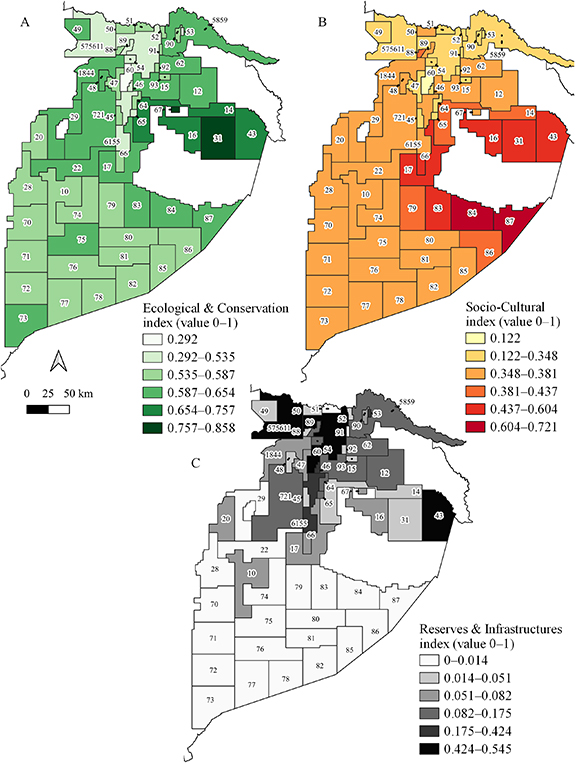
Figure 3. Maps of analysis units ranked through the TOPSIS simulations: (A) E&C index, (B) SC index and (C) R&I index.
Download figure:
Standard image High-resolution image
Figure 4. Graph showing the results of TOPSIS simulations for the three indexes, as presented in maps in figure 3. Activo-block units are listed in ascending order (from bottom to top) for the R&I index and are divided between exploited/in production and promotion/exploration analysis units.
Download figure:
Standard image High-resolution imageActivo-block units display different degrees of ecological and conservation relevance, with a minimum value of 0.292. The highest values correspond to the Apaika Nenke block (ID 31) as well as to contiguous units in the northern part of the Yasuni National Park. SC units have high values all around the 'Zona Intangible Tagaeri Taraomenane' (ZITT, intangible zone for uncontacted indigenous people Tagaeri Taraomenane), particularly in the south (ID 84 and 87). Units with low values occur where R&I have high importance, especially in the northern part of the Amazon (ID 60, 575 611 and 6155), with the only exception of ITT block ID 43, whose values are high for all simulations. In the low value areas, possible benefits gained by oil activities are negated by oil impacts that have occurred during the last 50 years. About half of the units present very low values for R&Is because these elements are concentrated in productive areas or areas exploited in the past, while ITT block represents an exception due to the higher presence of probable and possible reserves. All values are available in table 3 in excel format of supplementary data.
3.3. Unburnable carbon areas
The different weighting combination of the three indexes previously created allow for the simulation of different development scenarios, each with different priorities regarding future oil activities in the EAR (figures 5 and 6). Map 5A demonstrates an EDS, which prioritizes ecology and conservation; Map 5B demonstrates a SCDS giving priority to the wellbeing of local communities; Map 5C demonstrates a FFDS, which prioritizes the oil industry. The more negative the value, the more ideal the area is for defining an unburnable carbon territory. The full analysis table (table 3 in excel format) with values is available in supplementary data.

Figure 5. Maps showing the ranking of the activo-block units according to EDS (A), SCDS (B), FFDS (C). Last map (D) shows the units that share the same rank positions for two or more scenarios. The more negative the value, the more unburnable the activo-block unit for that scenario.
Download figure:
Standard image High-resolution image
Figure 6. A graph showing the value of each analysis unit for each scenario, as presented in maps in figure 5. The more negative the value, the more unburnable the activo-block unit for that scenario.
Download figure:
Standard image High-resolution imageIn all simulations, activo-block units that should remain unburnable or where oil operations should cease are mainly located in the center-southern sector of EAR, where there is no report of reserves and the presence of oil infrastructure is low. In contrast, sMCDA showed for all simulations that units located in the northern sector (ID 60, 575 611 and 6155), particularly along the 'Auca' oil roads system, are currently the ones most subjected to fossil fuel extraction. Due to the large proven oil reserves in this sector, fossil fuel and industrial infrastructure development started early, in 1970. The negative socio-environmental impacts of these activities are well documented (Hurtig and Sebastián 2004, Finer et al 2008, Sabin 2013, Zurita-Arthos and Mulligan 2013, McCracken and Forstner 2014, Webb et al 2015, 2017, Barraza et al 2018). Before any decision is made on continuing oil activities in this region, remediations of the past pollution, reparative justice measures to local communities and new best practices in oil operations should be implemented to avoid, mitigate and compensate negative direct and indirect impacts to human and environmental health. For 30 years different sectors of local civil society gathered in the organization UDAPT ('Union de Afectados y Afectadas por las Actividades Petroleras de Chevron-Texaco', Union of People Affected by Chevron-Texaco's Oil Activities) have campaigned for human and nature's rights and against contamination by oil activities. Examples of these are the campaign to stop gas flaring and the lawsuit to the oil company Texaco, now Chevron, for remediation of past damages (Facchinelli et al 2022).
The analysis highlights that the Amazonian sector covered by units 31, 16, 67, 14, 17, 87, 84, 83 located around the ZITT and its buffer zone should remain without oil development. This result is largely determined by the Presidential Decrees (Presidencia de la Republica del Ecuador 1999, 2007) that established these areas as 'no go zones' for anthropic activities. The size of ZITT was recently increased (El Comercio 2018) and oil block boundaries delimited so that there is no overlap with this area. However, oil blocks still surround the ZITT and cover most of its buffer zone. Block 43, which was the block of interest in the Yasuni-ITT Initiative, ranks as unburnable according to the SCDS and EDS. At the same time, it is the fourth preferred block for oil exploitation according to the FFDS because of the presence of large probable and possible reserves. Lastly, Map 5D highlights the analysis units that share the same rank positions between two or more different simulations. The top three most exploitable activo-blocks are the same for all simulations. This results from the important presence of reserves and oil infrastructure in these areas.
It is worth noting that these rankings are the result of specific selected criteria and weights originating from simulated discussions among stakeholders carried out by the research groups.
3.4. Unburnable carbon areas according to 2 °C and 1.5 °C scenarios
McGlade and Ekins (2015) and Welsby et al (2021) estimated the total amount of global unextractable reserves of fossil fuels for a 2 °C global temperature increase cap goal (about 30%) and a 1.5 °C cap goal (about 60%) respectively. We applied these to the amount of Ecuadorian proven reserves reported in the 'Informe Hidrocarburífero 2018'. Maps in figure 7 show the number of activo-block units for each development alternative that would correspond to about 70% of proven oil reserves (Maps A–C) and about 40% of proven oil reserves (Map D). To provide a visual scenario for leaving oil underground, unburnable carbon units are represented in red in the case of the public company Petroecuador and in yellow in the case of units granted in concession to private companies. It is assumed that it will be easier for Petroecuador, a public company, than to its private counterparts to close or cease any new initiatives of oil exploitation. By considering the work of McGlade and Ekins (2015), FFDS needs eight activo-block (corresponding to 11 blocks in production) to reach 70%, followed by SCDS (9 units, or 13 productive blocks) and EDS (10 units, or 14 productive blocks). These results suggest that between 22 and 25 oil blocks in production should stop their activities. For all three simulations, the most exploitable units are in consolidated oil extraction areas. Notably, even if the FFDS alternative identifies fewer activo-blocks for extraction compared with the other two alternatives, it is done at the expense of the ITT block (block 43), which has higher ecological and SC values. As shown in Map 7D, according to all simulations to meet the 1.5 °C maximum temperature increase target only the first two activo-block units can be exploited: ID 575 611 (three productive blocks with ID 57, 56 and 11) and block 60.

Figure 7. Unburnable carbon areas and exploitable areas according to cumulated proven reserves toward 2 °C (about 70% of proven reserves are exploitable, maps A–C) and 1.5 °C (about 40% of proven reserves are exploitable, map D) of total proven reserves, for the different scenarios.
Download figure:
Standard image High-resolution image
4. Conclusions
In 2007, Ecuador pioneered an innovative initiative that targeted the supply side of fossil fuels by proposing to leave the ITT oil block inside Yasuní National Park untapped in exchange for monetary compensation from the international community. In 2013, because of a variety of factors that included the limited international financial contributions received, domestic tension about national energy policy and a lack (at that time) of established approaches for supply side initiatives at the global climate institutions, this initiative was abandoned.
At present time, the climatic emergency (IPCC 2022) requires a strong commitment to mitigation and gives rise to interest in supply side policies to complement existing demand side measures. These policies involve a managed reduction in fossil fuel extraction, promoting the phasing out of fossil fuel facilities and selecting burnable and unburnable reserves to meet the carbon budget. Importantly, this process involves defining where to leave fossil fuels untapped. The cultural and natural conservation value of the area above the target reserves should be part of this decision.
Since the PA (COP21 2015) and The Lofoten Declaration (2017), an accepted general principle for addressing the global climate emergency is that developed countries should take the lead in climate change mitigation actions on the basis of their disproportionate contribution to global emissions, as well as their wealth relative to developing countries. Recent research has emphasized the need for command-and-control policies, proposing a treaty of non-proliferation of fossil fuels (Newell and Simm 2020), considering the limits of the market in managing emissions reductions and the polarized debate about economic efficiency versus social equity.
In the debate between efficiency and social equity, the equity issue has been largely reduced to creating new sources of employment other than those in the fossil fuel based economic system and the need for low HDI countries to access affordable and secure energy. Research is usually focused on the regional and national scales, using overall economic indicators and, in some cases, general social indicators unrelated to the reserve specific geographical area.
In addition, few studies consider site specific environmental conditions, analyse the political, economic and social dynamics within countries, or examine the role of transnational companies in phasing out fossil fuels.
In a geographical perspective 'place matters'. According to the Science Panel for the Amazon, the Amazon rainforest has reached a tipping point. Therefore, defining unextractable fossil fuel areas should become a priority and should involve human and environmental sensitivity as guiding principles (Science Panel for the Amazon 2021). If a portion of global reserves must remain in the ground, those under the areas of highest global conservation value should be among them.
Moreover, in low HDI countries fossil fuel operations do not necessarily lead to equitable and durable sustainable development. As the case of Ecuador illustrates, the extractivist paradigm does not guarantee meaningful development nor the eradication of poverty. Instead, fossil fuel operations most commonly translate into spatially determined social injustice, with the people living in the extraction areas bearing the highest costs and none of the benefits. They become the 'sacrifice zones'. Promoting secure livelihoods and stable communities (Kartha et al 2018) while contributing to climate change mitigation and biodiversity conservation requires immediate actions to avoid the further violations of human and nature rights. In the Ecuadorian Amazon, action is urgent. Indirect impacts of oil activities, in particular deforestation, should also be considered in this discussion. Best practices in oil development should include the monitoring and reduction of deforestation, one of the first causes of greenhouse gas (GHG) emissions in Ecuador, where the main driver was and is the expansion of agriculture frontier by small scale settlers, facilitated by new roads open mostly for oil extraction. A program to limit oil frontier extraction, and promote roadless oil exploitation may substantially reduce deforestation. The program must be complemented with promotion of alternative options for poor peasants in tropical areas and a GIS monitoring system may provide an effective control program.
The PA calls for the cooperation of developed and developing countries in the battle against climate change through ambitious and innovative solutions within a framework of progress towards sustainable development (Articles. 2, 6, 10). Thus, nations must coordinate efforts and devise innovative tools for the selection of burnable and unburnable reserves to meet the carbon budget, ensuring that humans and the environment are protected in the process. The sMCDA presented here is in alignment with the PA through its innovative approach to climate smart decision making for selecting unburnable reserves -greenhouse gas reservoirs (Article 5)- considering economics, people and nature. It aims to be a tool for the transition to low carbon sustainable development for biologically rich developing countries with fossil fuels. It contributes to joint climate solutions involving the technical and financial collaboration between developed and developing nations (Article 6.1).
Based on the application of the sMCDA tool to the case study of Ecuador, we were able to rank alternative development options taking into consideration not only availability of reserves but also parameters relevant to sustainable development such as in situ social, cultural and biodiversity values. The aim of the tool is to serve as the basis for participative decision making on burnable and unburnable reserves as part of a low emissions development path for developing countries transitioning away from fossil fuel dependence and contributing to global climate change mitigation. In the case of Ecuador, its development can be founded on its unique biodiversity and cultural heritage. The transition strategy must be based on identifying, selecting and promoting key sectors of the economy with high sustainable and equitable development potential. In the initial stages, the focus may be in the more readily available options such as tourism and renewable energy, and in the longer term a planned and sustained strategy of development must be devised. Building on public–private partnerships, such a strategy must aim to consolidate a competitive advantage by investing in the needed infrastructure, institutional strengthening, research, education, training, coherent with the promotion of value added based on the sustainable use of the Amazon: a bioeconomy of standing forests and flowing rivers as proposed by the Science Panel for the Amazon 2021 report (Science Panel for the Amazon 2021). In its Article 6, the PA recognizes the possibility of voluntary cooperation among nations and allows for international transfers for the improvement of mitigation outcomes. This opens up the opportunity for supply side climate policy and the re-examination of proposals akin to the Yasuni-ITT Initiative, where the mitigation action of leaving fossil fuels unexploited -and abstaining from the resulting income- is made by the developing nation, and the wealthier nations collaborate with financial flows for the shared benefit of the mitigation outcome.
In addition to this colossal challenge, practical and pervasive barriers exist. To promote efficient and effective decision-making: spatial data and information should be free and open, machine readable and available at a finer scale. This is presently not the case, especially for oil and gas infrastructures. Oil project and reserve information is often difficult to access or is very expensive, not reliable and available only in pdf format unsuitable for processing. Should these datasets become more accessible, sMCDA can become an even more effective tool for supporting the definition of unburnable carbon areas and meeting the global carbon budget.
Data availability statement
All data that support the findings of this study are included within the article (and any supplementary files).
Funding
This research is part of the activities of 'Climate Justice Jean Monnet Center of Excellence' with the support of Erasmus + Programme of the European Union, call for proposals EAC/A02/2019–Jean Monnet Activities; Decision No. 620401; Project No. 620401-EPP-1-2020-1-IT-EPPJMO-CoE.