


INTRODUCTION
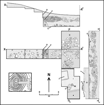
Survey and mapping conducted at Tula by the Instituto Nacional de Antropología e Historia (INAH) and the University of Missouri in the early 1970s identified three prominent mound/plaza complexes along the main ridge, overlooking the Río Tula, that constitute the core of the ancient city (Figure 1, inset). At the south end of the ridge is Tula Grande, the monumental complex extensively explored and restored by Acosta, which comprised the city's civic/ceremonial center during its Early Postclassic/Late Tollan phase apogee (Table 1; Healan et al. Reference Healan, Cobean and Bowsher2021). Immediately to the north is a mound/plaza complex, commonly called the Plaza Charnay, after the nineteenth-century explorer who conducted exploratory excavations there. Further north is Tula Chico, whose smaller size and striking similarity in layout to Tula Grande led Matos (Reference Matos Moctezuma and Moctezuma1974) to assign the two monumental centers their respective names.

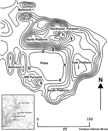
Figure 1. Location (inset; after Yadeun Reference Yadeun and Matos1974) and topographic map of Tula Chico by Jesús Acevedo, showing (a–k) principal structures and location of exploratory excavations described in text. Image prepared by Healan.
Table 1. Revised chronology for Tula and the Tula region (after Healan et al. Reference Healan, Cobean and Bowsher2021).

Both surveys and the initial excavations described below revealed that the area including and immediately surrounding Tula Chico contained an unusually high percentage of Coyotlatelco ceramics, associated with Tula's earliest occupation during the Early and Late Corral phases (Table 1), leading Matos (Reference Matos Moctezuma and Moctezuma1974) to suggest that Tula Chico was the administrative center for Tula's initial settlement and the prototype for the later Tula Grande. In addition, the relative paucity of Tollan phase ceramics at Tula Chico suggested that it not only preceded Tula Grande in time, but was abandoned early in the city's history and was subsequently surrounded by the expanding Tollan phase city.
Figure 1 is a recent topographic map of Tula Chico that presents our proposed nomenclature for the visible topographic features that make up the monumental complex. Other than the two ballcourts, we have avoided duplicating the nomenclature of spatial counterparts at Tula Grande since, despite their similarities, the two complexes are by no means identical in layout. Their most notable similarities include a massive platform along the north side, supporting a large pyramid at the east end; a large ballcourt along the west side; a large ballcourt beyond the north platform; and a few large pyramidal structures amid the monumental architecture. In addition to its smaller size, Tula Chico's most notable differences from Tula Grande include no apparent counterpart to Pyramid C along the east side; a large pyramid in the southwest corner of the plaza; the apparent absence of a prominent adoratorio in the plaza; and its approximate north–south orientation compared to Tula Grande's orientation of approximately 17 degrees east of north. Nevertheless, the overall similarity in layout between the two is striking and raises a number of tantalizing questions, including whether the distinctive features of Tula Grande's art and architecture were also characteristic of Tula Chico, a possibility given additional importance in light of the ongoing debate about the origins of the so-called “Toltec style.” If indeed it were the monumental center for Tula's earliest settlement, systematic exploration of Tula Chico could shed significant light on Tula's origins and the factors behind its rise to prominence in the Early Postclassic period.
PREVIOUS INVESTIGATIONS
In 1941, as part of Acosta's ongoing project at Tula, Hugo Moedano excavated three exploratory pits to tepetate, the local calcareous “bedrock,” at a locality called Huapalcalco, which, according to Acosta (Reference Acosta1945:53), lay around 1 km northeast of Tula Grande, the approximate location of Tula Chico. Acosta published ceramic frequencies for the pit containing the greatest number of sherds, noting that the lowest levels contained mostly Coyotlatelco ceramics and a previously unknown type whose description matches that of what is now called Guadalupe Red on Brown Incised, a diagnostic ceramic of the Prado complex described below (Table 2; Cobean Reference Cobean1990:75–92). Although many of Acosta's descriptive ceramic categories cannot be assigned with certainty to types in Tula's formal ceramic sequence as defined by Cobean (Reference Cobean1990), those that were generally exhibit the same temporal trends seen in the recent excavations described below. Although it would appear that Moedano's test pits came from the general locality of Tula Chico, the depth below surface of tepetate (approximately 2.85 meters) greatly exceeds that for any of the excavations described below, which, along with the abundant Tollan phase ceramics in the upper levels, suggest that Moedano's pits were not placed within Tula Chico itself.
Table 2. Ceramic phases, corresponding ceramic complexes, and principal types in the Tula ceramic chronology (Cobean Reference Cobean1990).

In the 1970s, both the University of Missouri and INAH conducted exploratory excavations at Tula Chico (Cobean Reference Cobean, Guadalupe, Mastache de Escobar, Cobean and Healan1982; Matos Reference Matos Moctezuma and Moctezuma1974). These included one pit inside Ballcourt 2 (Figure 1a), four along the sides of the plaza (Figures 1b–1e), and one located approximately 200 meters to the southeast. All six pits were 2 × 2 m wide and were excavated to tepetate, located between 1.7 and 2.0 m below the surface, and in every case, ceramics and other artifacts were recovered from levels that directly overlay tepetate. All five excavations in the plaza and adjacent ballcourt encountered multiple compacted earth layers, possibly previous plaza floors, and two encountered remnants of stucco floors, lacking walls or other evidence of associated structures, although these were very limited exposures. In all five pits inside Tula Chico, Coyotlatelco was the predominant ceramic complex, while Tollan complex ceramics were confined to generally sparse frequencies in the uppermost levels (Cobean Reference Cobean, Guadalupe, Mastache de Escobar, Cobean and Healan1982:Figures 6–8; Matos Reference Matos Moctezuma and Moctezuma1974:Figure 9). On the other hand, the one pit placed outside Tula Chico proper encountered a residential structure in the upper levels associated with large quantities of Tollan phase ceramics (Cobean Reference Cobean, Guadalupe, Mastache de Escobar, Cobean and Healan1982:Figures 9 and 12).
The abundant Coyotlatelco ceramics recovered from Cobean's exploratory excavations at Tula Chico played a major role in his formulation of the initial phases of the Tula ceramic chronology (Cobean Reference Cobean1990). In addition to Coyotlatelco ceramics, which he designated the Corral complex at Tula, Cobean identified a distinctive ceramic complex that co-occurred with Corral complex ceramics in the lowest levels of his excavations, which he designated the Prado complex. Principal Prado complex types include well-made, painted and incised red on brown and black polished serving vessels (Table 2). Based on these data, Cobean (Reference Cobean1978, Reference Cobean1990) divided the Coyotlatelco-related occupation at Tula into two phases, which he designated the Prado and Corral phases: the earlier containing both Prado and Corral complex ceramics, and the later containing almost exclusively Corral complex ceramics.
While Prado complex ceramics consistently occupy the lowest levels of local sequences, Corral complex ceramics are almost always more numerous, even in levels where Prado ceramics are at peak popularity. In light of this, Healan and Cobean (Healan et al. Reference Healan, Cobean and Bowsher2021) have renamed the Prado and Corral phases the Early Corral and Late Corral phases, respectively, as seen in Tables 1 and 2, thereby recognizing the dominance of Corral complex ceramics in both phases, while retaining the name Prado to refer to the distinctive ceramic complex that reached its peak popularity during the Early Corral phase.
RECENT INVESTIGATIONS
In 1988, INAH initiated a program of exploratory excavation of all of the principal monuments at Tula Chico, including the North Platform and its surmounting Northwest Pyramid, East Platform, Southwest Pyramid, Ballcourt 2, and the central plaza (Figures 1f–1k). As described below, these investigations have clarified various aspects of Tula's earliest settlement, its relationships to previous settlement in the region, and to the subsequent Early Postclassic city and its contemporaries.
Excavations of the North Platform and the Northeast Pyramid
A major component of these investigations was exploratory excavation of its two most prominent features, the North Platform and the Northeast Pyramid. Exploration of the North Platform involved two operations, the first of which, conducted in 1988, was a 3 × 3 m pit on the platform surface immediately east of the Northeast Pyramid (Figure 1f). Excavation encountered artifact-rich fill, containing Corral complex but no Prado complex pottery, and disappointingly was suspended some 2.5 m above the current plaza surface. A radiocarbon sample (B280294, Table 3) from the lowest level yielded a calibrated date with an undesirable wide two-sigma range, spanning the Late Corral and Terminal Corral phases.
Table 3. Calibrated radiocarbon dates obtained from excavations at Tula Chico. B.P., before present.

* A: University of Arizona; B: Beta Analytic.
A second exploration of the North Platform, conducted in 2002, involved a transect of 3 × 3 m pits along a portion of its south face (Figure 1g), in an effort to expose the platform facade and locate the plaza floor. Unfortunately, excavation was unable to locate the facade, which appears to have been destroyed, and in its place was an extensive deposit of rubble that seems to have derived from intentional destruction or looting. Nor did excavation encounter an identifiable floor for the plaza. Several of the excavations extended into the platform core, and identifiable ceramics were Corral complex with no Prado complex ceramics, which, together with the ceramics and radiocarbon date from the 1988 excavation, indicate that the North Platform was constructed during the Late Corral phase.
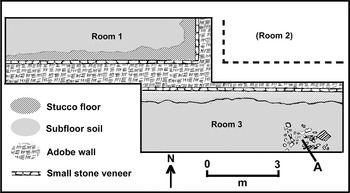
Excavations atop the Northeast Pyramid were conducted in 2002 (Figure 1h) as two parallel, overlapping, east–west transects of 3 × 3 m pits (Figure 2). In the northern transect, an ill-defined structure was encountered around 40 centimeters below surface, containing a pavement of adobe blocks whose interstices contained traces of wood. On the pavement was what appeared to be the base of a masonry pillar measuring approximately 1 meter on each side. This structure, designated Structure NE-2, was mostly destroyed, given its proximity to the surface and to a large looter's pit that had removed most of the northern portion. It appears to be relatively recent in age, although information regarding associated ceramics is not available. At the time of excavation, the top of the pyramid supported a dense line of organ pipe cactus, a common feature of house construction in rural areas now and in the recent past.

Figure 2. Plan view of Structure NE-1 atop the Northeast Pyramid. Image prepared by Healan.
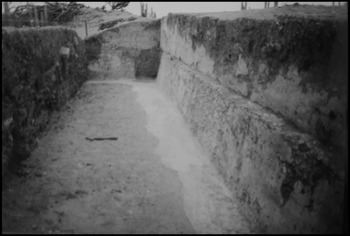
Immediately beneath Structure NE-2, excavation encountered a layer of rubble and soil nearly 1.6 m thick, overlying the remains of a prehispanic structure designated Structure NE-1, presumably a temple, that was erected on top of the pyramid. Approximately 25 centimeters of the upper rubble and soil layer was mostly soil, below which was dense rubble, consisting mainly of unworked stone, but also beams and other carbonized wood pieces, adobe fragments, many of which were burned, and numerous pieces of worked stone, including sculpture, described below. Beneath the rubble layer was a layer of soil around 20 cm thick, overlying stucco floors and adobe walls comprising Structure NE-1 (Figure 2). The partially exposed wall system included a north–south wall, apparently separating two interior rooms, designated rooms 1 and 2 in Figure 2, and an abutting east–west wall bordering a single long room designated room 3, containing the remains of what appears to have a been a pillar (Figure 2a), suggesting that room 3 was an open portico facing the plaza. The east–west wall was constructed of adobe, with a talud or sloping layer of tabular stone along its base that was covered with painted stucco (Figure 3). The wall was well-preserved, measuring some 1.8 m at its highest point.

Figure 3. Room 1, Structure NE-1, Northeast Pyramid, facing west. Note stucco-covered adobe wall with basal talud and remnant of stucco flooring along base of wall. Photograph by Healan.
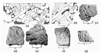
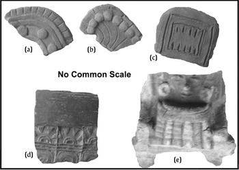
Among the sculpture recovered from the rubble layer were two nearly whole or substantial fragments of carved rectangular panels (Figures 4a and 4b), each depicting a richly attired individual in a reclining pose, similar to many examples Acosta encountered in Building 3, the so-called “Palacio Quemado,” and Building J at Tula Grande. Like many of those depicted at Tula Grande, both individuals hold a staff-like object affixed with bows. In addition to these two, other fragments of sculpture were recovered that appear to represent portions of three other representations of reclining figures, including two faces in profile (Figures 4c and 4d) and an object with bows (Figure 4e). All of these specimens were encountered in the upper portion of the rubble layer, 1 m or more above the Structure NE-1 floor, along with stone “columnitas,” circular motifs or chalchiuites, and a fragment of an almena, a decorative element commonly used as a roof ornament, suggesting that all of this sculpture had been placed on the roof or along an opening in the ceiling. This agrees with Acosta's interpretation regarding the location of these objects at Tula Grande. Elizabeth Jiménez García (personal communication, 2019) has noted that the distinctive bow and tassel element adorning the front of the headdress of the individual in Figure 4a also appears immediately behind the individual in Figure 4b, suggesting that the latter panel depicted a succession of at least two reclining individuals.

Figure 4. Representations of reclining figures from Tula Chico. (a–e) Structure NE-1, Northeast Pyramid; (f and g) Structure SW-2, Southwest Pyramid. From Jiménez García Reference Jiménez García2012.
Excavation did not proceed beneath the Structure NE-1 floor into the underlying pyramid, but ceramic and chronometric evidence described above suggests that the North Platform on which the pyramid was erected was constructed during the Late Corral phase. We assume that both the Northeast Pyramid and Structure NE-1 are likewise Late Corral phase in date, given that Corral complex ceramics were recovered from levels overlying the Structure NE-1 floor. However, the majority of diagnostic sherds recovered from these levels were Tollan complex ceramics, indicating that the structure was not only still standing, but probably occupied during the Tollan phase, specifically the Early Tollan phase, given the presence of Mazapa pottery and the paucity of Jara pottery, both characteristics of that phase (Table 2). Moreover, a radiocarbon date (B280291, Table 3; Figure 5) obtained for a probable roof pole from the rubble layer, some 16 cm above the stucco floor, yielded a two-sigma range that fell almost entirely within the a.d. 900–1000 time span of the Early Tollan phase. Thus it appears that Structure NE-1 was not only occupied during the Early Tollan phase, but underwent roof and perhaps other repairs.

Figure 5. Stratigraphic sequence (Harris matrix) for the Northeast Pyramid and North Platform excavations, and probability distributions for associated radiocarbon dates in Table 3. Image prepared by Healan.
Prior to structural collapse, a large portion of the stucco floor in both rooms was removed, leaving only an uneven remnant of stucco along the base of both walls (Figures 2 and 3). This is almost certainly not the result of a looter's pit or other intrusion, since no loose fragments of stucco flooring were encountered; the exposed area beneath the removed flooring appeared to be undisturbed; and the flooring had been removed in rooms 1 and 3, hence on both sides of the wall (Figure 2), while the wall and adjacent flooring remained intact. It thus appears to represent independent activity in each room, in which a large portion of the stucco floor was removed prior to collapse. This kind of systematic activity is perhaps more appropriately characterized as dismantling rather than simple destruction, although its purpose is unknown. It could represent recycling of stucco, although there is no shortage of lime in the Tula region.
The carbonized beams and other wood and the burned adobe fragments indicate that Structure NE-1 was burned, and their occurrence throughout the rubble layer suggests that burning and collapse occurred at the same time. No charred beams or rubble were encountered on the floor itself, which was separated from the rubble layer by around 20 cm of soil, hence the building may have lain abandoned for some time prior to burning and collapse.
To summarize, we believe that the North Platform and the Northeast Pyramid were probably constructed in the Late Corral phase, at which time the pyramid supported a structure (NE-1) that may have had a portico or frontal gallery, featuring sculpture that included reclining human figures like those of later Tollan phase structures at Tula Grande. At some point, a large portion of the stucco floor of Structure NE-1 was removed, and the structure was abandoned and subsequently burned and collapsed, although these events almost certainly did not occur at the same time, given the layer, approximately 20 centimeters thick, of rubble-free and charcoal-free soil that overlay the floor. Both ceramic and radiocarbon evidence indicate that the structure was still standing, and was occupied and even maintained during the Early Tollan phase—hence burning and collapse occurred some time later. Finally, Structure NE-2 was constructed atop the ruins during the historic period.
Excavations at Ballcourt 2
As previously noted, exploratory excavations at Ballcourt 2 were conducted in 1976 (Figure 1c), extending into the underlying plaza and approximately 1.7 meters of fill overlying tepetate. No specific data are available regarding the ceramic inventory, but excavation notes indicate substantial quantities of both Prado and Corral complex ceramics. A radiocarbon date (A5039, Table 3; Figure 6) was obtained for a carbonized maize cob from the level overlying tepetate, which yielded a date whose probability distribution spanned the early fifth through mid-seventh centuries. This raised the intriguing possibility that the earliest occupation at Tula Chico dates to the Middle Classic period, although little attention was paid to this single, possibly erroneous date at the time.

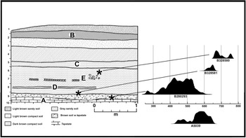
Figure 6. Generalized profile for the 2005 Ballcourt 2 excavations, and probability distributions for associated radiocarbon dates in Table 3. Date A5039 is from 1976 excavations. Image prepared by Healan.
In 2005, two 3 × 3 m pits were placed side by side at the northeast corner of Ballcourt 2 (Figure 1i) and excavated in 20 cm level increments to tepetate, which lay approximately 1.8 meters below (Figure 6a). The top two layers contained numerous fragments of worked and unworked stone (Figure 6b), derived from the collapsed ballcourt facade. Level 5 saw a dramatic increase in sherds and animal bone, suggestive of trash introduced as fill, which continued in high frequency all the way to tepetate at the bottom of level 9 (Table 4). A layer of superposed, discontinuous bands of compacted soil, possibly earlier plaza surfaces, was encountered in level 5 (Figure 6c), and another in level 8 (Figure 6d). In level 7, stucco floor fragments and possible wall remnants were encountered (Figure 6e). In the lowest level, a nearly complete Prado complex vessel and a partial Corral complex vessel were recovered from a thin soil layer approximately 1–2 centimeters above tepetate. The overall stratigraphic picture suggests initial occupation in an area with shallow topsoil, with subsequent episodes of construction and filling that elevated the plaza floor to a height approaching 2 m over time.
Table 4. Ceramic inventory for 2005 excavation, Ballcourt 2, reporting number of sherds by level per phase.

Three radiocarbon dates were obtained, one of which was for a charcoal specimen from level 9 in the thin soil layer overlying tepetate (B280293, Table 2; Figure 6), whose probability distribution fell almost entirely in the three centuries prior to a.d. 600, thus providing a second Middle Classic date for a stratigraphically early context. Moreover, as seen in Table 4, level 9 and the immediate overlying levels contained significant amounts of Chingú phase (Teotihuacan) ceramics, including the brazier fragments and figurine seen in Figure 7. These two dates, associated Chingú phase ceramics, and additional chronometric and ceramic data presented below collectively provide cogent evidence that the initial occupation of Tula Chico occurred during the Middle Classic period, thus contemporaneous with the Chingú phase occupation in the surrounding region. As seen in Table 4, however, most of the identifiable ceramics in the levels containing Chingú phase ceramics are Prado and Corral complex sherds, hence Middle Classic Tula Chico was not a Chingú phase, but rather an Early Corral phase settlement, thus extending the beginnings of that phase back by perhaps as much as two centuries from its previous projected beginning date of a.d. 650 (Healan and Cobean Reference Healan, Cobean, Nichols and Pool2012; see also Healan et al. Reference Healan, Cobean and Bowsher2021).

Figure 7. Examples of Chingú phase ceramics recovered from 2005 Ballcourt 2 excavations. (a–c) Composite brazier fragments; (d) vessel sherd; (e) figurine. Photographs by Healan.
The other two dates (B328581, B328580, Table 3) were obtained for animal bone from two different levels of the overlying plaza fill (Figure 6). The former was located near the bottom of the fill layers and yielded a probability distribution that falls entirely within the a.d. 600–700 range, mostly Early Corral phase, while the latter is from about midway in the fill deposits, with a notably later range that falls mostly within the Late Corral phase. Collectively, the three dates from this excavation and their stratigraphic contexts indicate that, despite the initial settlement in the Middle Classic period, construction of the plaza, and presumably the surrounding monumental complex, did not begin until sometime after a.d. 600 and continued well into the Late Corral phase.
No identifiable Tollan complex or Aztec pottery was encountered in excavation, but five early Colonial sherds were recovered from level 3, some 40–60 cm below surface (Table 4). This suggests an undetected intrusion, presumed to be the result of looter activity, which may account for the relative low quantity of artifacts above level 5.
Excavations of the East Platform
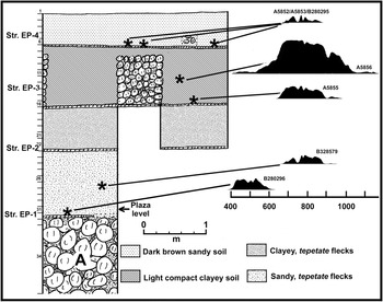
In 1988, two 3 × 3 m pits, placed side by side atop the East Platform (Figure 1j), were excavated, some 4.6 m through the platform and into the underlying strata. Portions of four superposed structures were encountered, each containing a stucco floor and, in some cases, stone wall remnants separated by layers of soil fill, often rich with artifacts (Figure 8). Structure EP-4, the latest of the four, was the most extensively exposed, exhibiting several walls and at least two interior rooms. Heavy damage from a large intrusive pit prevented a clear determination of the floor plan and wall orientation, although it appeared to have essentially the same north–south orientation as Structure NE-1 atop the Northeast Pyramid. The structure had apparently been burned, given the presence of several carbonized beam fragments on the floor and numerous fragments of burned clay, presumably adobe, in the overlying levels.

Figure 8. Generalized profile for the East Platform excavations, and probability distributions for associated radiocarbon dates in Table 3. Image prepared by Healan.
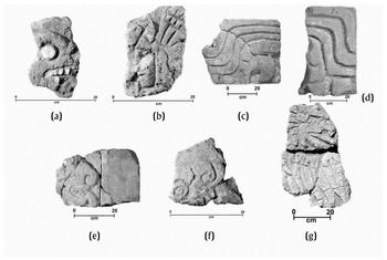
Over 80 fragments of worked stone were encountered on or within 10 cm of the Structure EP-4 floor, including a representation of a human skull (Figure 9a) that Elizabeth Jiménez García (personal communication, 2019) noted is similar in form to those encountered by Acosta on the El Corral pyramid altar. These may have been parts of roof or ceiling elements like those encountered in the Northeast Pyramid excavations. In the next four levels beneath the Structure EP-4 floor, excavation encountered over 70 additional fragments of worked stone that were presumably associated with the underlying Structure EP-3 (Figure 8). These included a representation of a human face in profile, wearing a headdress reminiscent of the panache worn by the Atlanteans atop Pyramid B at Tula Grande (Figure 9b).

Figure 9. Representations of (a) a human skull; (b) a human head (both from Structures EP-4 and EP-3, East Platform); (c, d) probable feathered serpents; (e) feline; (f) unknown animal; (g) avian, all from Structure SW-2, Southwest Pyramid. From Jiménez García Reference Jiménez García2012.
The wall remains associated with Structures EP-4 and EP-3 were left in place, restricting the amount of exposure of the two underlying structures as excavation proceeded. Structure EP-1, the deepest structure, overlay a massive layer of boulders (Figure 8a), some measuring up to 60 cm in length. The boulder layer extended for at least 1.2 m, at which point excavation was discontinued due to its increasing instability. Evidence from the other excavations suggests that the initial occupation of the Tula Chico locality occurred on a thin soil surface overlying tepetate, which at the East Platform would probably have lain just below the limits of excavation. Structure EP-1 thus appears to have been placed on a boulder-filled platform over 1 m in height that had been erected on the natural surface. The boulders may have been part of a system of cajones, a grid of intersecting walls whose cells were filled with boulders, a common mode of platform construction at Tula Grande and elsewhere (Báez Urincho Reference Báez Urincho2021; Gamboa Cabezas and Healan Reference Gamboa Cabezas and Healan2021; Sterpone Reference Sterpone Canuto2000–2001:Figures 29–31).
Table 5 shows a predominance of Tollan complex pottery among the identifiable ceramics in the layers overlying the remains of Structure EP-4, along with a few Aztec sherds, which may indicate that, like Structure NE-1 atop the Northeast Pyramid, Structure EP-4 was occupied during the Early Tollan phase. Unlike Structure NE-1, however, these sherds were not part of a sealed deposit, hence this could not be determined with certainty. Beneath Structure EP-4, Corral phase ceramics are more abundant, although Tollan phase types continued to occur along with ceramics diagnostic of the Terminal Corral phase, probably a result of the disturbance caused by the intrusive pit mentioned above. Below Structure EP-3, Corral phase ceramics predominate, and below Structure EP-1, notable amounts of Prado complex ceramics occur, suggesting an Early Corral date. Of particular interest are a small number of sherds in various levels identified as Middle Classic Chingú complex ceramics comparable to those encountered in the Ballcourt 2 excavations. Their occurrence over a wide range of levels identified as fill in Figure 8 suggests material incorporated into platform fill.
Table 5. Ceramic inventory for East Platform excavation, reporting number of sherds by level per phase.

Seven radiocarbon dates were obtained (Table 3; Figure 8), three from the floor of Structure EP-4, one from the floor of Structure EP-1, and three from intervening fill. All three dates from Structure EP-4 (A5852, A5853, B280295) were samples of carbonized beams on the floor, indicating that it, like the Northeast Pyramid, had been burned. In Figure 8 these three dates have been pooled, yielding a mean estimated date of 1234 ± 19 B.P. and a strikingly multimodal probability distribution that encompasses the Late Corral and Terminal Corral phases.
The date associated with Structure EP-1 (B280296, Table 3; Figure 7) was obtained for a fragment of carbonized wood that also appears to have been part of a beam or roof pole, recovered from slightly above the floor. Also present were fragments of burned clay (adobe?), which, together with the carbonized structural wood suggests that Structure EP-1 had likewise been burned. The radiocarbon date exhibits a probability distribution that falls entirely within the a.d. 400–600 time range, which, along with the presence of Chingú phase ceramics in fill layers, provides further evidence that the initial occupation of the Tula Chico locality was contemporaneous with the Middle Classic Chingú phase occupation in the Tula region.
The remaining three dates (A5855, A5856, B328579, Table 3) were obtained for small charcoal specimens recovered from the fill layers between Structures EP-1 and EP-4. Each of the three exhibits essentially the same temporal range as for the pooled samples from Structure EP-4, suggesting that Structures EP-2, EP-3, and EP-4 were all constructed during the Late Corral and Terminal Corral phases (Table 1).
In summary, excavation of the East Platform revealed a long and complex construction history involving two distinct structural entities, the first of which was Structure EP-1 atop a platform constructed of boulders or boulder-filled cajones. Structure EP-1 stratigraphically and chronometrically predates much, if not all, of the Tula Chico plaza construction activity, which chronometric data from Ballcourt 2, presented above, suggest did not begin until after a.d. 600. It was presumably part of an earlier monumental complex whose plaza would probably have been the existing land surface. The remains of Structure EP-1 lay below the plaza surface on which Structure EP-2, the first stage of the East Platform, was erected. Structure EP-2 was subsequently razed and covered by fill to support a new structure (EP-3), a process that was later repeated with the construction of EP-4.
While all three episodes of East Platform construction apparently occurred during the Late Corral or Terminal Corral phases, chronometric and probably the ceramic data suggest that Structure EP-1 was built during the Middle Classic period—additional evidence that the initial occupation at Tula Chico occurred during the Chingú phase occupation in the surrounding region.
Both Structures EP-1 and EP-4 appear to have been burned, the latter presumably part of the same activity that included the burning and destruction of NE-1 atop the Northeast Pyramid. Previously, some authors (Diehl Reference Diehl1983:45; Mastache et al. Reference Mastache, Cobean and Healan2002:74) tied this activity to conflict between political factions that led from Tula Chico to Tula Grande as Tula's center of power, although an alternative perspective is offered in the final section, below. The burning of Structure EP-1 may have been part of ritual termination activity prior to construction of Structure EP-2, which could be additional evidence that the former structure was a component of an earlier monumental complex unrelated to the later East Platform. Similar evidence of possible ritual termination was encountered in the Southwest Pyramid excavations, discussed immediately below.
Excavations at the Southwest Pyramid
The Southwest Pyramid (Figure 1k) has no counterpart at Tula Grande. The initial exploration strategy called for excavating a transect eastward from its summit (Figure 10, inset) to expose the uppermost structure. Excavation on the mound itself encountered rubble from a pyramid whose only extant portion was the lowest courses of the facade on its eastern face (Figure 10a). This pyramid, designated Structure SW-3, was found to be the latest of three superposed structures, each associated with a different period of occupation.

Figure 10. Plan view of exploratory excavations on the east side of the Southwest Pyramid (inset). Letters refer to features described in text. Image prepared by Healan.
Immediately east of the Structure SW-3 facade, excavation encountered a dense concentration of rock, approximately 20 centimeters below the surface (Figure 10b), which was initially assumed to be rubble associated with the collapse of the pyramid. Subsequent excavation, however, revealed this feature to be a layer of loose stone, nearly 1 meter thick, intentionally deposited as fill and extending beneath Structure SW-3. The rock was mostly tepetate, ranging in size from small cobbles to boulders measuring up to nearly 50 centimeters in length. Beneath the rock layer was a layer of artifact-rich soil, approximately 1 meter thick, that in turn overlay a stucco floor (Figure 10c) littered with numerous fragments of worked stone, including architectural elements and sculpture (Figure 10d). The stucco floor abutted a sloping wall beneath Structure SW-3 (Figure 10e) that formed the basal talud of an earlier structure, designated Structure SW-2. Only the lowest 50 cm of the talud remained, and was overlain by a layer of large boulders approximately 1.2 meters thick (Figure 10f) that apparently served as a base upon which Structure SW-3 was erected. The Structure SW-2 talud was constructed of stone cobbles with a thick facing of mud plaster, and as noted below, appeared to have been faced with worked stone. Both Structures SW-3 and SW-2 appeared to have the same approximate north–south orientation as Structure NE-1.
Clearly the sculpture and architectural fragments on the stucco floor were derived not from Structure SW-3, but from the underlying Structure SW-2. The stucco floor did not actually abut the Structure SW-2 talud, instead terminating with an upward curl in front of it, leaving a gap of approximately 6 centimeters that may have held panels or other decorative facings whose fragments lay among the scattered worked stone. The soil and rock layers that overlay Structure SW-2 and the stucco floor were fill that was intentionally introduced to cover the partially razed structure and establish a foundation for Structure SW-3.
The discovery of the earlier structure SW-2 and associated sculpture spurred excavation in the adjacent squares, which encountered the same layers of rock and artifact-rich soil overlying remains of the same stucco floor, likewise littered with architectural and sculpture fragments (Figures 10b–10d), whose expanse and lack of interior walls suggested the stucco floor was an exterior surface. Among the numerous worked architectural and sculpture fragments are seven human and animal representations, as identified by Jiménez García (Reference Jiménez García2012). These include two representations of reclining figures (Figures 4f and 4g) and five animal representations, including two possible feathered serpent representations (Figures 9c and 9d), a feline and an unidentified animal (Figures 9e and 9f), and a large-beaked, possibly psittacine bird (Figure 9g). Other elements include at least four fragments of benches decorated with “half star” Venus motifs (Mastache et al. Reference Mastache, Healan, Cobean, Fash and Luján2009:Figures 22 and 23).
Excavation at the south end of the expanded excavation continued below the stucco floor, encountering two successive layers of soil (Figures 10g and 10h), apparently fill, that overlay the remains of an even earlier structural complex that included a patio, altar and adjoining building (Figures 10i–10k). These remains, collectively designated Structure SW-1, are part of an undefined complex that appears to have been a residential compound. Only the northernmost portion of the building (Figure 10k) was exposed, including the remains of a two-step stairway that provided access to the patio. The partially exposed altar (Figure 10j) was a square or rectangular structure constructed of two or more courses of worked stone blocks. The lack of associated rubble suggests the altar was largely intact, but was open on top. It is similar in size and shape to altars found in patios of Tollan phase residential compounds, but lacked the sloping sides and small tabular stone facing typical of the latter. The building and its stairs were badly damaged, but appeared to have the same orientation as the altar, which was oriented approximately 4 degrees west of true north compared to the nearly perfect north–south orientations of the overlying Structures SW-2 and SW-3.
Limited excavation beneath the patio floor in front of the stairway encountered a burial of a large canid (Figure 10l), apparently a domestic dog like those encountered in excavations in the Cerro Malinche and Charnay localities (Paredes Gudiño and Healan Reference Paredes Gudiño and Healan2021). Adjacent to the dog burial was a small depression, with burned sides and filled with ash (Figure 10m), presumably a firepit. The burial pit penetrated an underlying compacted earth surface that appeared to be an earlier floor of the patio.
Several objects of note were encountered on the patio floor on the north and south sides of the altar, including five whole or partial human figurines, two whole utilitarian vessels, several loose human bones, and a concentration of ash. Elsewhere in the patio, a concentration of marine shells was encountered on the floor. Some or all of these objects may have been placed there immediately prior to deposition of the overlying soil fill. Similar activity associated with buildings undergoing abandonment believed to represent termination rituals have been identified at sites elsewhere in Mesoamerica, including elsewhere at Tula (Báez Urincho Reference Báez Urincho2021).
The first of two successive layers of fill overlying the patio and associated structures consisted of a layer, approximately 25 centimeters thick, of hard, yellow soil that covered the patio surface and altar (Figure 10h), including the interior of the altar that had apparently been left open. This layer, and the building along the south side, were then covered by a layer of loose yellow soil, approximately 75 centimeters thick, containing large quantities of sherds and animal bone (Figure 10g), over which was placed the stucco floor (Figure 10c) abutting Structure SW-2.
Figure 11 is a synthesis of the depositional events identified in the excavation at the Southwest Pyramid, in the form of a Harris matrix that delineates the three successive episodes of construction and occupation, the earliest of which was associated with Structure SW-1. It is not known if an even earlier occupation existed, since excavation did not proceed beneath the patio floor, but the other excavations suggest that tepetate lay only 10–20 cm further below.

Figure 11. Stratigraphic sequence (Harris matrix) for the Southwest Pyramid excavations, and probability distributions for associated radiocarbon dates in Table 3. Image prepared by Healan.
Most, perhaps 65 percent, of the identifiable sherds from both yellow soil layers beneath the stucco floor were Corral complex ceramics, while the remainder were Prado complex, suggesting an Early Corral phase date. Few ceramics were recovered from the rock and soil layers overlying the stucco floor (Figures 10b and 10c), for which data are not available.
Three radiocarbon dates (Table 3; Figure 11) were obtained from three different contexts, of which the earliest (B280298) in both stratigraphic and chronometric terms was a bone sample from the Structure SW-1 dog burial. Its probability distribution spans the latter half of the seventh through ninth centuries, generally corresponding to the Late Corral and Terminal Corral phases, although the bulk falls within the Late Corral phase. Another date (B328583) was obtained from a human scapula from the patio floor, whose probability distribution overlaps that of the dog burial, but mostly falls within the ninth and tenth centuries (Figure 11), corresponding to the latter part of the Late Corral and Terminal Corral phases. The third date (B280292) was obtained for a charcoal specimen on the stucco floor abutting Structure SW-2, which yielded a probability distribution strikingly similar to that of the human scapula. Assuming that the charcoal specimen had been part of Structure SW-2, it would appear that the placement of the human bone on the Structure SW-1 patio floor, deposition of the yellow soil layers, and construction of the stucco floor and Structure SW-2 all occurred within a relatively brief period of time in the latter part of the Late Corral or the Terminal Corral phase. Thus the three radiocarbon dates generally do not support the Early Corral phase dating, based on associated ceramics from the yellow soil fill layers, which may have incorporated earlier ceramic material.
In summary, limited excavation at the Southwest Pyramid revealed a lengthy and complex history of occupation, comparable to that encountered in the other excavations at Tula Chico, but not as early. No evidence of Middle Classic occupation was encountered, but excavation did not proceed to tepetate. A striking feature of the sequence documented in Figure 11 is the shift in function from a residential compound (Structure SW-1) to civic/ceremonial structures (Structures SW-2 and SW-3). Equally striking is the difference in post-abandonment activity associated with these two functional classes. Other than the probable razing of the building adjoining the patio to facilitate subsequent construction, post-abandonment activity for Structure SW-1 appears largely limited to placement of various objects on the courtyard floor prior to filling for subsequent construction, while Structure SW-2 appears to have been the target of extensive iconoclastic activity prior to its apparent razing and possible burning before the construction of SW-3. Iconoclastic activity directed at political and hieratic structures suggests overthrow, rebellion, and other political violence, but there are other possible explanations, which are considered in more detail in the following section. Given its considerably damaged state, Structure SW-3 may have met a similar fate, which would presumably have been part of the same activity as the burning of Structures NE-1 and EP-4.
DISCUSSION
Investigations at Tula Chico over the past several decades provide support for earlier ideas about Tula's early monumental center, while also providing new and challenging information, including revisions of chronology. On the one hand, these investigations support previous evidence that the construction of Tula Chico as Tula's first monumental center dates to the Epiclassic period, and thus supports current dating of the Late Corral phase, and at least the latter part of the Early Corral phase. On the other hand, ceramic and chronometric evidence presented above indicates that the initial occupation took place much earlier during the Middle Classic period, when the surrounding region was apparently under Teotihuacan domination during the Chingú phase. While these Middle Classic contexts included some Chingú phase ceramics, the vast majority is Corral and Prado complex pottery, hence Tula Chico's earliest settlement was not part of the Teotihuacan colonization of the Tula region, but one of a number of likewise intrusive Coyotlatelco-related settlements in the region that previous authors suggested may have overlapped in time with the former (Mastache and Cobean Reference Mastache, Cobean, Diehl and Berlo1989). Tula Chico provides, perhaps, the most concrete evidence to date for temporal overlap between Middle Classic Teotihuacan and the appearance of Coyotlatelco peoples in central Mexico.
Quite aside from demonstrating their contemporaneity, the co-occurrence of Chingú and Early Corral ceramics at Tula Chico suggests interaction of a non-hostile nature between the two cultures. In this regard, it is notable that Chingú ceramics at Tula Chico include those of a probable ritual nature (Figure 7), suggesting that these interactions included ideological content, as might be expected given the probable civic/ceremonial context of these sherds.
Our knowledge of the Middle Classic/Early Corral phase occupation at Tula Chico is limited, but structure EP-1, the boulder-filled platform and surmounting structure beneath the East Platform, is believed to have been part of a monumental complex that predated the plaza and the mound complex seen today. Stratigraphic data show that the locality subsequently underwent considerable modification, including deposition of up to 1.8 m of fill that elevated the plaza and surrounding structures above a terrain of thin soil and perhaps exposed tepetate. The presence of floors and other surfaces within layers of fill (Figure 6) indicate that the present plaza is a composite of multiple episodes of construction and filling.
The Southwest Pyramid excavations provide a complex history of occupation, beginning with a shift in function from initially residential to ritual, and a series of wholly independent construction events, with each event formally emphasizing its independence from its predecessor. This includes possible ritual abandonment activity associated with Structure SW-1 prior to construction of Structure SW-2, and the razing and apparent iconoclastic activity of Structure SW-2 prior to construction of Structure SW-3. That this iconoclasm was followed by construction of Structure SW-3 suggests that it was not a disruptive, but rather a programmatic process within the sociocultural and politico-religious milieu of Epiclassic Tula.
The enigmatic removal of portions of the stucco floors in Structure NW-1 prior to its destruction represents some type of systematic activity that we suggest is more appropriately characterized as dismantling rather than destruction, and in fact there is evidence of other activity that may shed some light on its purpose. In another article in this Special Section (Healan et al. Reference Healan, Cobean and Bowsher2021), the authors discuss two recent radiocarbon dates, plus one that Acosta obtained, in 1964, from Edificios 4, K, and 3, respectively, at Tula Grande, whose two-sigma ranges all fall completely, or mostly, within the Early Corral phase, despite evidence that the buildings at Tula Grande were constructed during the Terminal Corral or Early Tollan phase. Two of the three samples were obtained from column timbers, the third from either a column or roof beam, and they raise the possibility of the re-use of structural material originally in structures at Tula Chico. Such re-use could have been for purely pragmatic reasons—that is, re-use of a relatively rare resource (this seems less likely to be the motive for the removal of stucco flooring from Structure NW-1, given the abundant lime resources in the region). Alternatively, the re-use of materials from Tula's former monumental center in constructing the new center may have had symbolic connotations, underscoring the continuity that exists between the two.
A possibly related and equally significant discovery was that key elements of the distinctive corpus of relief sculpture common at Tula Grande were also common at Tula Chico, including contexts other than the latest structures (e.g., Structure SW-2). It is therefore clear that, contrary to previous claims (e.g., Bey and Ringle Reference Bey, Ringle, Kowalski and Kristan-Graham2007:396–397), the so-called “Toltec style” existed at Tula well before the Late Tollan phase. The implications of this temporally early sculpture for the ongoing debate about the primacy of this style at Tula versus Chichén Itzá have already been noted by Jordan (Reference Jordan2016), based only on a fraction of the corpus of specimens seen in Figures 4 and 9. These finds provide additional evidence for cultural continuity between Epiclassic Tula and the Early Postclassic city, and raise the possibility that some of the distinctive sculpture at Tula Grande may have been brought there from Tula Chico.
The latest construction stages of the structures excavated at Tula Chico all date to the Late Corral or Terminal Corral phase, thus supporting previous evidence that Tula Chico had ceased to function by the end of the Epiclassic period. At the same time, previous scenarios that the monumental center was totally abandoned and left in ruins appear to be inaccurate in light of evidence that at least one structure—the temple atop Tula Chico's principal pyramid—was occupied and even maintained during the Tollan phase. This may also have been the case for the contemporaneous structure atop the East Platform, but it was too badly damaged to confirm this. While it may be accurate to speak of “abandonment” in terms of the lack of subsequent building activity, it appears that Tula Chico continued to be occupied, at least on a limited basis, and its structures maintained within the expanding Early Postclassic city, indeed, “a situation not unlike the Acropolis surrounded by modern Athens” (Healan Reference Healan2012:81–82).
At least two of the latest structures at Tula Chico were burned, but in light of the above, this apparently did not occur until some time in the Tollan phase or later, although the lack of Aztec ceramics on the sealed floor of Structure NE-1 may indicate that it occurred prior to the arrival of the Aztecs at Tula. In light of this, evidence presented by Healan et al. (Reference Healan, Cobean and Bowsher2021) that the burning and destruction at Tula Grande preceded the Aztec occupation raises the intriguing prospect that both monumental centers were destroyed at the same time, seemingly part of a coordinated activity by unknown agents to destroy symbols of authority at Tula.
RESUMEN
Tula Chico es un complejo de plaza y montículos ubicado dentro del sitio de Tula, Hidalgo que, según un recorrido previo y la excavación exploratoria, fue el centro del primer asentamiento de Tula durante el período epiclásico y sirvió como modelo para Tula Grande, el centro monumental para la ciudad del período posclásico temprano. Excavaciones más recientes efectuados en Tula Chico exploraron porciones de cinco de los siete monumentos que conforman el complejo como se ve hoy. Dichas excavaciones revelaron una larga y compleja historia de ocupación que extendió desde su asentamiento inicial durante el período clásico medio hasta su aparente abandono al final del período epiclásico.
Excavaciones exploratorias de la Gran Pirámide al lado norte de la plaza encontró los restos de un templo que se había derrumbado y quemado. El piso del templo estaba sellado por una gruesa capa de escombro que incluyó muchos ejemplos de esculturas características del “estilo tolteca” en Tula Grande, lo que indica que el estilo estuvo presente en Tula durante el período epiclásico. La cerámica recuperada del piso incluyó cerámica diagnóstica de la fase Tollan (alrededor de los 900–1150 d.C.), lo que indica que el edificio todavía estaba intacto y estaba ocupado durante el apogeo de Tula durante el período posclásico temprano. Una fecha de radiocarbono también de la fase Tollan obtenido de material del techo sugiere que la estructura no sólo era ocupada sino que era mantenida durante ese tiempo.
Las excavaciones debajo de Ballcourt 2 y la Plataforma Este revelaron que la plaza estaba construida de aproximadamente 1,7 metros de relleno sobre estructuras anteriores construidas sobre roca madre expuesta. La datación por radiocarbono y la cerámica asociada revelaron que Tula Chico fue colonizado por los pueblos Coyotlatelco durante el período clásico medio, cuando una gran parte de la región estaba bajo el control directo de Teotihuacán, así extendiendo los orígenes de Tula hasta 200 años en el tiempo.
ACKNOWLEDGMENTS
The authors wish to thank Elizabeth Jiménez García for generously allowing us to reproduce some of her unpublished photographs.


 Open access