

INTRODUCTION
They were in their hundreds and armed with guns, machetes and clubs. Some of them were naked, with ashes and markings of charcoal on their faces and bodies. They were yelling and charging at us and there was nowhere to run. Behind us was a high wall. I don't know how, but I scaled the fence. I ran as fast as I could. It was when I stopped to catch my breath that I realised my mother, older brother and aunt never made it. I wanted to go back and die too. I can still hear the wild yelling of those bloodsuckers.Footnote 1
This one account of the violence that overtook Jos in 2008 echoes the experience of many residents in the Nigerian city.Footnote 2 Survivors in some of the hardest-hit neighbourhoods describe how armed mobs invaded and murdered their loved ones. While individuals were attacked by neighbours in some instances, a common eyewitness claim is that their settlements were overrun by outsiders. Corroborating this, police reports indicate several rampaging mobs were apprehended on their way to or from unleashing violence in residential areas that were not their own.
Research on collective violence has long stressed ethnic composition to explain a locality's susceptibility to riots (see Boal Reference Boal1976; Olzak Reference Olzak1983; Horowitz Reference Horowitz1985; Nagel Reference Nagel1994; Brubaker & Laitin Reference Brubaker and Laitin1998; Fearon et al. Reference Fearon, Kasara and Laitin2007; Peach Reference Peach and Schönwälder2007; Kasara Reference Kasara2012). Two competing views have come to dominate the ethnic composition and collective violence literature. One group of scholars argues that segregation engenders violence by breeding in-group solidarity and out-group resentment (Boal Reference Boal1972; Byrne et al. Reference Byrne, Gormley-Heenan and Robinson2012; Kasara Reference Kasara2013; Cunningham & Gregor Reference Cunningham and Gregory2014). This view draws from contact theory which holds that segregation fosters prejudice and entrenches negative perceptions and attitudes towards members of the outgroup (see Pettigrew Reference Pettigrew1998; Hewstone et al. Reference Hewstone, Cairns, Voci, Hamberger and Niens2006; Pettigrew et al. Reference Pettigrew, Tropp, Wagner and Christ2011). Stressing the relationship between segregation, fear and violent sectarianism in Belfast, Shirlow (Reference Shirlow2003: 77) found that segregation ‘aided the reproduction of inter-linked spatial devices, which have enacted both violence and conflict’.
Another group of scholars argues the opposite, maintaining that ethnically mixed areas are more susceptible to violence (Shirlow & Murtagh Reference Shirlow and Murtagh2006; Weidmann & Salehyan Reference Weidmann and Salehyan2013). This perspective is based on the assumption that contact between members of rival groups increases the likelihood of frictions that can ignite confrontations (Kaufmann Reference Kaufmann1996). Within this paradigm, Bhavnani et al. (Reference Bhavnani, Donnay, Miodownik, Mor and Helbing2014: 1) found that Belfast's increased segregation following the frequent conflicts of the 1960s and 1970s helped prevent resurgences. In Baghdad, Weidmann & Salehyan (Reference Weidmann and Salehyan2013) observed how a sharp drop in group violence corresponded with high residential segregation, arguing that demarcations between adversarial neighbourhoods reduced contact and thus propensity for confrontations. Similarly, violence appeared likelier to occur in the ethnically diverse areas of Afghanistan (Bhavnani & Choi Reference Bhavnani and Choi2012). An earlier study of Belfast (Jarman & O'Halloran Reference Jarman and O'Halloran2001) found ethnically mixed areas more violence-prone than homogenous neighbourhoods demarcated by sharp boundaries.
This article identifies an issue that has perpetuated, if not compounded, the ambivalence of conflicting findings: a tendency to ignore the mobility of most mobs and to conflate their origins with the locations of their violence. Accounts from riot-prone cities suggest violence is mostly perpetrated by highly mobile armed mobs. In Jos, much violence was by groups who went ‘on a rampage’ (see Higazi Reference Higazi2011: 26; Krause Reference Krause2011: 38; Reference Krause2017: 269). Of the 1984 Delhi riots, Tambiah (Reference Tambiah1997: 1179) noted ‘most of the mobs were from areas different from where they operated’. Also in India, Brass (Reference Brass2004: 4841) described how Hindu rioters moved around from one neighbourhood to the other attacking Muslims in Meerut. The literature is however hardly explicit about the effects armed mobs' mobility has on the spread of violence and what it means for mobs to be mobilised on or off their own turf. Conflation of rioters' origins and destinations in turn obfuscates our understanding of what it takes for a locality to be considered violent.
Addressing this concern, this article examines how ethnic composition combined with neighbourhood location – meaning situation vis-à-vis adjoining neighbourhoods of similar or dissimilar ethnic composition – and the nature of connecting infrastructure affect the mobility of armed mobs and, consequently, the spread of violence. Contrary to the determinist stance dominating segregation-diversity debates, this article argues that ethnically segregated and mixed neighbourhoods contribute differently but complementarily to violence's production. The central ideas are encapsulated in three propositions: armed mobs are likelier to originate in segregated neighbourhoods; violent events are likelier to occur in ethnically mixed areas, especially those between rivalling segregated settlements; and armed mobs prefer using alleys that are narrow, unplanned and inaccessible to security forces. The rest of the article proceeds thus: the following section critically reviews existing literature on rioters' ethnic composition, neighbourhood location and spatial patterns. Next is a note on research design and methods followed by a contextual discussion of the 2008 post-election violence. After an outlining of the context comes an empirical analysis of the spatial patterns of rioters in the 2008 riot in Jos based on mobile interviews. The section first traces rioters' footsteps in and around a segregated neighbourhood and then a mixed neighbourhood. Drawing upon the empirical section, the subsequent part specifies and discusses the factors enhancing and impeding armed mobs' mobilisation and mobility. Lastly, the conclusion reflects on the academic and practical implications of the findings.
RIOTERS' ETHNIC COMPOSITION, NEIGHBOURHOOD LOCATION AND SPATIAL PATTERNS
The common proposition that armed mobs are likelier to emerge from segregated settlements is based on beliefs that ethnic concentration facilitates intra-group communication, eases mobilisation and increases potential for confrontation against the out-group (Weidmann Reference Weidmann2009). Lichbach (Reference Lichbach1995) elaborates three ways in which ethnic concentration can shape conflict behaviour. First, it brings group members into close interaction, which reinforces ‘cognitive proximity’ to establish what Weidmann (Reference Weidmann2009: 7) called ‘collective grievances'. Second, organising collective action is more cost-effective in a homogenous concentrated territory than in dispersed or mixed territories. Third, an effective reward and penalty system to deter ‘betrayal’ and sustain the struggle is more feasible in a concentrated territory than other settings. Similarly, Laitin (Reference Laitin2004: 365) found that group concentration predicts rebellion and conflict far more than other factors, including inequalities and grievances. Weidmann (Reference Weidmann2009: 7) accordingly hypothesised that ‘population dispersion of a group leads to lower risk of conflict involvement’. We therefore expect groups in segregated areas to be likelier to mobilise and engage in violence than their counterparts in mixed localities.
In combination with ethnic composition, a neighbourhood's location affects its vulnerability to violence (see Jarman Reference Jarman2004). The contested boundary hypothesis and the notion of the frontier offer useful insights into how this works. Legewie & Schaeffer (Reference Legewie and Schaeffer2016) described the contested boundary as an ethnically mixed socio-geographic context where the other group's presence is perceived as a threat; there is polarisation and ambiguity about social rank and exclusive ethnic identities; contestations concerning group turf are more pronounced than in ordinarily mixed areas. Combined, these mechanisms dispose the contested boundary to greater conflict, beyond the frictions that generally characterise mixed neighbourhoods (Legewie & Schaeffer Reference Legewie and Schaeffer2016: 132). An ethnically mixed neighbourhood located between segregated settlements exemplifies the contested boundary. Boye & Kaarhus (Reference Boye and Kaarhus2011) noted how such boundary neighbourhoods become sites of contestation as each group tries to usurp resources in the locality.
Evidence associating violent incidents with boundary neighbourhoods, known as interfaces in Belfast (Shirlow Reference Shirlow2003; Jarman Reference Jarman2004), supports the contested boundary argument. Jarman & O'Halloran (Reference Jarman and O'Halloran2001) observed that the city's ‘buffer zone’ – a type of interface wherein a mixed settlement falls between two segregated neighbourhoods – is more violence-prone than homogenous neighbourhoods demarcated by sharp boundaries. Relatedly, the notion of the frontier exposes the dynamics of violence in an ethnically mixed neighbourhood located between segregated settlements. Kotek (Reference Kotek1999: 228) said frontiers are ‘not only polarised on an ethnic or ideological basis … but are, above all, disputed because of their collocation on fault-lines between ethnic, religious or ideological wholes', leaving this ‘territory for two dreams’ beleaguered by conflicting claims. Returning to the case of Jos and based on these scholars' arguments, I expect Nasarawa Gwong, an ethnically mixed neighbourhood between segregated settlements, to be relatively more vulnerable to violence than other mixed neighbourhoods that are not similarly located.
Some of the main reasons neighbourhood ethnic composition and location matter concern how these factors affect the mobilisation and mobility of armed mobs. Mobs have received comparatively little attention even though their role in revolutions and other riotous events is incontrovertible. Rudolph's (Reference Rudolph1959: 448) work on the activities of mobs in the 18th century's French and American revolutions detailed mobilisation and attacks – on, respectively, the Bastille in Paris and Fort George in New York – by mobile mobs as crucial points in the revolts. Of Paris, Tilly (Reference Tilly2000: 148) reported how mobs ‘coursed the streets between the Hôtel de Ville and the Bastille’.
Studies on Indian cities have highlighted how social network dynamics can instigate riots. Brass (Reference Brass2004) discussed what he calls a ‘riot system’, a network of politicians, government officials and local criminals who instigate, coordinate and sustain riots. Berenschot (Reference Berenschot2011) similarly illustrated a complex patronage network comprising politicians, local criminals and residents who helped spread violence in Ahmedabad. He found that this mobilisation proved more feasible in poor neighbourhoods where residents lacked direct access to government institutions and basic amenities. As Sewell (Reference Sewell, Aminzade, Goldstone, McAdam, Perry, Sewell, Tarrow and Tilly2001: 51–2) noted, some of these accounts tend to treat space ‘as an assumed and unproblematized background, not as a constituent aspect of contentious politics that must be conceptualized explicitly and probed systematically’. Although 18th-century revolutions are a different political context from ethnic violence in contemporary plural societies, the spatial conditions that give rise to mobs and armed networks tend to persist. For example, Tilly (Reference Tilly2000) conceived of segregated areas as ‘safe spaces’ where intra-group communication is unconstrained. The logic is that the mobilisation of people into mobs is more feasible in ‘safe areas’, where ‘contentious claim making gains protection from routine surveillance and repression because of terrain, built environment’, and individuals freely engage in ‘speech-making that would have brought rapid incarceration to their participants elsewhere in the metropolis’ (Tilly Reference Tilly2000: 144). Similar to Rodger's (Reference Rodgers2009: 5) observation that youth gangs ‘symbolically epitomize urban violence in the Nicaraguan collective consciousness’, armed networks in Jos represented social anxiety and fear. In the latter's case, however, beyond the collective trepidation they seem to cause, the networks are appreciated, and even respected, being seen as neighbourhood protectors when riots erupt.
Also worth evaluating is how roads and barriers affect rioters' mobility, thereby contributing to shaping the spread of violence (see Brand Reference Brand2009; Kutmanaliev Reference Kutmanaliev2015). Physical environment was found to influence rioters' choice of routes and targets during the London riots, with highways and rivers acting as barriers against offenders (Baudains et al. Reference Baudains, Braithwaite and Johnson2013). Empirical evidence from criminology also suggests that any of these physical features' presence between a would-be offender's residence and a potential target diminishes the chances the offender will choose that target (Clare et al. Reference Clare, Fernandez and Morgan2009). Tilly (Reference Tilly2000: 140) argued that location can constrain or facilitate conflict by ‘showing that diffusion of a movement or an organizational form follows previously established lines of communication’.
These ideas help in the construction of a spatial profile of ethnic riots, even if nebulous at this stage. As this article describes, the profile shows that armed mobs are more likely to originate from ethnically segregated neighbourhoods. They prefer alleys that are hidden and inaccessible to security forces. Violence is disproportionately concentrated in mixed neighbourhoods that share contiguous boundaries with segregated neighbourhoods. Contrary to the determinist stance that dominates the segregation-diversity debates, this model shows how ethnically segregated and diverse settlements both contribute to the production of violence, albeit differently. Following the actual footsteps of rioters within and across neighbourhoods in Jos shows the extent to which this theoretical conjecture aligns with empirical evidence.
RESEARCH DESIGN AND METHODS
This article draws from an ethnography that investigated the spatial practices of rioters during the ethnic violence that ravaged parts of Jos from 27–29 November 2008. Conducted intermittently between September 2015 and August 2017, the study comparatively explored the spatial patterns and behaviour of armed mobs in two neighbourhoods. Both neighbourhoods are located within the city centre, have roughly 30,000 residents and have comparable levels of congestion, unemployment, deprivation and inadequate physical and social infrastructure. However, the two neighbourhoods differ in ethnic composition and location.
Angwan Rogo is religiously segregated, having been a Muslim neighbourhood since the September 2001 riots in Jos, while Nasarawa Gwong is ethnically and religiously mixed. The segregated case shares several parts of its boundaries with other segregated settlements and one part with an ethnically mixed neighbourhood. On two sides the neighbourhood is separated from the adjacent segregated areas by a major road; on another side there is no main road, and the neighbourhood is contiguously linked to the adjoining ethnically mixed area through narrow back roads. Ethnically mixed Nasarawa Gwong is located between segregated settlements with which it shares contiguous boundaries connected by a web of narrow lanes. Although both neighbourhoods have featured prominently in official and research reports on violent riots in Jos, there remains no systematic examination of the spatial patterns of rioters within and across their boundaries.
Throughout the article, the term ‘ethnic’ is used in an encompassing sense similar to how Horowitz (Reference Horowitz1985) used it to capture all conflicts based on ascriptive group identities, including language, religion, race, caste, tribe and sect. In line with this, ‘ethnic segregation’ can be either religious or ethno-linguistic or both. In Jos city centre, segregation is mainly religious but also ethnolinguistic in some cases, since religious and ethno-linguistic boundaries tend to overlap. I differentiate between religious and ethnolinguistic segregation when there is a need to make specific references to either of them, otherwise I generally use ‘ethnic segregation’ in a broad sense to refer to either or both.
Methods and data sources I used include primary school common entrance examination registers, mobile interviews, key informant interviews (KII) and graphics depicting mental maps and routes by participants. The research involved many informal discussions with residents, eyewitnesses, survivors of violence, security forces, NGO fieldworkers, ethnic and religious leaders, local politicians and academics.
The three in-depth mobile interviews I conducted involved talking and walking with participants in the 2008 violence. The walk started at the point where the participant recalled joining other rioters and ended where violence erupted. Discussions were open-ended, though led by questions concerning how residents of the interviewee's neighbourhood responded upon learning of the violence; whether residents gathered at a single point or in separate groups at different points; identification and estimated number of gathering points; details on whether rioters were led by youth leaders, vigilantes, local criminals, elders or others; and exactly where and how the violence unfolded. These talks lasted between 30 and 45 minutes, though the length of the walks varied greatly. The longest walk was about one and a half kilometres; the shortest was about 150 metres. I had intended to audio record the interviews, but within minutes of the first, recognised the excessive environmental noise as well as how recording prevented the respondent from moving and expressing himself freely; I therefore settled for note-taking throughout the mobile interviews.
The four KIIs I undertook sought to reveal the role of neighbourhood leaders in mobilisation processes, construct a general profile of the neighbourhoods where nodes of mobilisation and violence were located and determine the dominant conflict frame in the area. The KIIs also helped cross-validate some data obtained through mobile interviews. Dozens of other interviews and discussions within the neighbourhoods and elsewhere in Jos, which I had done for previous projects, complemented the data for this study. The KII was organised around several discussion points. Respondents were asked to describe their neighbourhood's population, unemployment level, poverty level; how they understood the 2008 violence and the Jos conflict, in general; how the residents' association responded when news about violence broke; and how other neighbourhood associations responded. Another question concerned whether response patterns in their neighbourhoods were centralised and organised or decentralised and disorganised.
Mobile interviews and KIIs were analysed thematically according to five coding categories: key actors in the mobilisation; centralised or decentralised mobilisation; routes types (involving main roads accessible to vehicles vs. narrow footpaths); distance covered; points of violence (whether inside or outside the neighbourhood, involving segregated or mixed populations and on what route types); type of neighbourhood boundary (contiguous or separated); and key actors in violence (armed mobs + rival armed mobs or armed mobs + armed forces). These categories were then grouped and discussed under three themes: points at which individuals formed into mobs; the type of mob routes; and points of violence.
My interviewees were found via snowballing sampling, though my selection was based on individuals' length of residence in the neighbourhood, territorial representation, and, for mobile interviews, participation in the 2008 riots. The mobile interview respondents all actively participated in the violence. Each of the KII respondents had been a prominent residents' association member for at least 10 years and lived in the neighbourhood for longer.
Nasarawa Gwong has both Christian and Muslim populations, so I conducted mobile interviews with one riot participant from each group. My Christian guide was a 41-year-old with no formal employment who occasionally engaged in menial jobs as a source of livelihood. He was born in another part of the city, but had been a resident of Nasarawa Gwong since age 12. He was 32 when the 2008 violence happened. My Muslim guide was a 39-year-old trader who had resided in the neighbourhood since birth. He was 30 when the violence happened. In segregated Angwan Rogo, my guide was a 33-year-old born and raised in the neighbourhood, and apart from short visits to relatives outside, he had never left the city. Not formally employed, he engaged in odd jobs and different trades to support his young family. He was 24 when the violence happened.
Since Nigerian censuses do not record ethnic and religious composition, I used public primary school common entrance examination registers as a proxy to determine the religious composition of the neighbourhood in which the school was located. I analysed the graduating classes of 2005 as a representative sample of the school since these pupils all sit for the final written test to gain admission into secondary school. The class register contains full names and graduation year, among other information, allowing me to categorise the pupils as ‘Muslim’ or ‘Christian’. In Jos and in much of Nigeria, an individual's name is usually an indicator of his or her religion. In using this method, however, misidentification cannot be completely ruled out since in central and northern Nigeria there are Christians with Hausa and Muslim-sounding names. To minimise the likelihood of misidentification I conducted a robust ‘ground truthing’ exercise that involved talking to heads of schools, neighbourhood leaders and a random sample of residents to provide a rough estimate of the ethnic composition of their neighbourhood. In both neighbourhoods, the school registers seem to provide a fairly accurate representation of their ethnic composition. Table I shows the ethnic composition of Angwan Rogo and Nasarawa Gwong on the basis of these data.
Table I Ethnic composition of Angwan Rogo and Nasarawa Gwong in 2005

Using interviews has its limitations. A major concern is the extent to which memory can be trusted. Some of the events discussed had happened nine years prior. Event details could have been blurred by time's passage or trauma or from repeatedly discussing and hearing the stories of others. That said, some survivors cannot forget their traumas. To mitigate the risk from such issues, I triangulated information from different sources and regularly compared my findings against reports by scholars and NGOs. To cross-validate my findings, I undertook a ‘ground truthing’ process involving extensive informal discussions with randomly selected residents and other individuals considered knowledgeable on violence in Jos. These efforts give me good reason to believe the data I obtained are reliable.
Jos experienced several other episodes of ethnic violence apart from the 2008 riots, notably in 2001, 2010 and after. I chose 2008 for this case study because I could access individuals who actively participated in those riots and agreed to walk me through the routes. Although my ethnographic research also allowed me to meet and talk with participants in the 2010 riots, most of them declined doing a guided walk. Moreover, since the 2008 riots have mostly been studied alongside other episodes of violence, examining them alone could uncover hitherto unnoticed or under-analysed dimensions.
THE 2008 POST-ELECTION VIOLENCE
There is a significant volume of literature that discusses the issues that underpin adversarial group relations in Jos (see Ostien Reference Ostien2009; Krause Reference Krause2011). At the heart of the conflict is the dispute over indigeneity. On one side of the divide are three ethnolinguistic groups considered indigenous to the Jos Plateau, namely Afizere, Anaguta and Berom; on the opposing side are the Hausa, who arrived in the area more recently than the indigenes but established themselves in urban Jos before other groups. Although the conflict has been about indigeneity and ownership of the city, violence has always taken a religious tone. Individuals are maimed and killed, not because they are indigenes or Hausa, but because they are Christian or Muslim. As a result, members of other ethnic nationalities not directly involved in the indigeneity dispute have also become entangled in the riots (Madueke Reference Madueke2017: 87–8). This literature has extensively described the social and political issues that translated into tremendous violence (see Higazi Reference Higazi2011; Krause Reference Krause2011; Ostien Reference Ostien2009; Best Reference Best2007). Contemporary politics of exclusion, lack of institutional capacity to regulate ethnic competition, tensions between indigenes and settlers and Nigeria's citizenship crisis created a perfect storm, with ensuing violence causing thousands of deaths, many more injuries and displacements (see also Kwaja Reference Kwaja2011; Mang Reference Mang, Fois and Pes2013).
The 2008 violence began over disputed local government elections for the chairmanship of Jos North LGA. Since its creation from greater Jos in 1991, the Jos North LGA has been a hotbed of ethnic rivalry. The predominantly Muslim Hausa felt the LGA belonged to them because the new boundaries placed most of the mainly Christian indigenous Berom outside Jos North, thereby leaving the Hausa as the majority. They were confident they would elect one of their own as chairman. To avoid losing as they did in the 1999 elections – when Frank Tardy, an indigenous Christian, was elected chairman – this time, intense political campaigning would ensure the Hausa population voted for their candidate, running under the opposition umbrella of the All Nigeria People's Party (ANPP). For their part, indigenes, with the support of other Christians, doubled their efforts to ensure the election of a Christian. The stakes were in their favour because the governor, Jonah Jang, who controlled the Plateau State Independent Electoral Commission, was a Berom Christian. Jang also belonged to the ruling People's Democratic Party (PDP), known for using state machinery to rig elections and impose candidates. When Muslims approached Jang to negotiate a power-sharing arrangement, he rejected the idea. The absence of power-sharing has been a key factor in making Jos particularly violence-prone (see Bunte & Vinson Reference Bunte and Vinson2016). The Muslim community became exasperated when Governor Jang chose one of his kinsmen, a Berom and an indigene of Du in Jos South, as the PDP candidate. These developments provide a broad stage-setting for the catastrophe that was to come (Ostien Reference Ostien2009).
On 27 November 2008, council elections were held across Plateau State's 17 LGAs. Candidates from the ruling PDP and the main opposition ANPP were foremost in the running for the Jos North LGA chairmanship. Christians mainly aligned with the PDP and Muslims with the ANPP, as per the respective candidates' religions. This was consistent with patterns in most of Nigeria, where it is common for ethnic identity to determine political affiliation and the direction of votes. The elections were largely peaceful, with no major disturbances recorded. However, the Hausa became suspicious after a last-minute relocation of the collation centre by the state's electoral body. Trouble began at the centre when ANPP party agents and loyalists started protesting about what they suspected was an attempt to rig the elections by PDP officials. The police dispersed the crowds using teargas. Large-scale violence started sometime between when the crowds left the collation centre and when they arrived in their neighbourhoods. As they made their way home, the crowds looted and destroyed shops while alerting co-ethnics via phone and word of mouth to come out and fight. Before dawn, many neighbourhoods erupted (see Human Rights Watch 2009; Ostien Reference Ostien2009).
The scale and intensity of the violence was astonishing (Human Rights Watch 2009). It concentrated in the city's poorer settlements, where people were targeted on the basis of their religion, not their political affiliation (Krause Reference Krause2011). Rampaging mobs moved around the city, killing and maiming anyone of the opposite faith (Higazi Reference Higazi2011). Similar to Jos's 2001 violence, youths mounted roadblocks and killed motorists who could not prove they were co-ethnics, for example, by reciting a particular prayer. In other situations, they were killed on the basis of dress (Human Rights Watch 2009). Although in Jos, Muslims often wear kaftans and Christians more often wear Western-style clothing (see also Trovalla et al. Reference Trovalla, Adetula and Trovalla2014), this is not always the case, so many people were mistakenly killed by co-ethnics who thought, on seeing their apparel, they were of the opposite faith (Krause Reference Krause2011).
After two days of fighting, calm was restored following firm intervention by a joint force of military and mobile police (MOPOL). The violence's tragedies (see Krause Reference Krause2011) included massive destruction of built property (homes, offices and businesses) and religious institutions. The Muslim community reported a razing of 23 mosques; Christians claimed an undisclosed number of churches as burnt down or destroyed. Human Rights Watch (2009) estimated that at least 133 of the hundreds of people that were killed were summarily executed by security forces, notably the MOPOL, and there was no recourse to justice. Overall, an estimated minimum of 700 people were killed and over 10,000 displaced during the two days of fighting (Higazi Reference Higazi2011).
RIOTERS' FOOTSTEPS IN AND AROUND A SEGREGATED NEIGHBOURHOOD
My guided walk in Angwan Rogo started at the southern end of the main street, where two-storey buildings marked a gateway into the neighbourhood. The buildings are part of the neighbourhood shopping hub, selling groceries, clothes, GSM recharge cards and services in tailoring, printing and photocopying, inter alia. On our walk, dozens of shoppers crowded around, though my guide recalled how none of the shops was open on the morning of the riots. Still, many residents gathered. They convened to discuss how Christians were killing Muslims in other parts of the city and were planning to invade the neighbourhood. Although informal and unruly, the discussions were led by neighbourhood leaders and local politicians. Gunshot sounds and thick swirls of smoke appearing in the sky from around the city made the tales of massacres, even if exaggerated, believable. Moments after he joined the shopping hub gathering, my guide followed a northward gravitation towards the neighbourhood centre.
This gathering slowly built into a crowd as it moved down the neighbourhood's main street. This 5-metre wide dirt road is flanked by several rows of buildings, divided into rows and columns by footpaths that run parallel and perpendicular to the main street. Most of the buildings are what Nigerians call ‘compounds', square-shaped edifices with a single entrance and semi-detached units with doors overlooking a small courtyard. Most compounds are inhabited by extended families, comprising multiple generations. Because homes are frequently owner-occupied, many residents have been neighbours with each other for at least a generation – sometimes up to three. Long-time residence and the fact that residents belong to the same ethnic group contribute to high social trust and collective efficacy observable in the neighbourhood. Research has noted how long-time residence helps stabilise social ties (Coleman Reference Coleman1988), which can positively affect social efficacy, while ethnic segregation can increase capacity for collective action (Sampson & Groves Reference Sampson and Groves1989).
The majority of neighbourhood residents who came out did not participate in the riots. They simply walked around and discussed the situation with co-ethnics. However, from the gathering there emerged an armed mob of young males, most between ages 15 and 40. While most were ordinary residents, leading them were local criminals and activists known to work closely with politicians. These same individuals, I was told, had been seen canvassing for votes at the neighbourhood polling stations the day before, during the elections.
According to my guide, before joining the crowds, these criminals held clandestine meetings at discrete sites used for selling drugs and making other illicit exchanges. Called ‘jungles’ or ‘ghettos’ locally, the sites were out of the public eye and thus perfect for gathering and distributing weapons to fighters. While easily accessible weapons such as machetes, knives and sticks were openly distributed on the street, where fighters converged, more sophisticated firearms were distributed at the jungles. Considered ‘contraband’, they included pistols, shotguns and automatic rifles. My guide described how a friend of his sighted a dozen young men distributing sophisticated weapons among themselves while consuming large amounts of drugs and other hard substances in one such jungle. I could not gain information on who was responsible for buying the weapons but the city is known to have witnessed an increase in the proliferation of small arms and light weapons since the violence of 2001. As the hysteria on the streets grew and became more riotous, I was told, the criminals simply slipped in and took control of the crowds. In ordinary times, these criminals are individuals known to engage in burglary, theft, drug peddling and other antisocial activities that constituted a nuisance to residents. However, in the charged atmosphere of rioting, armed and emboldened by drugs, they portrayed a fearless disposition that instantly attracted crowd members behind them.Footnote 3
Tracing the rioters’ footsteps started in earnest when we branched off the main street onto one of several alleys leading into the neighbourhood's inner recesses, onto back roads. The mostly mud buildings behind the street were in close quarters, the myriad of intersecting alleys no doubt confusing to a newcomer. I observed how they simultaneously served as a runoff for liquid waste from lavatories and a playground for many frolicking children. This was the path used by the armed mob. The route was narrow and winding. Rioters must have kept in a file since the space was barely enough for two people to walk side by side. There were several wider, less tortuous paths, but the rioters preferred those that provided cover because, besides being inaccessible to security forces, they kept the rioters anonymous to family, friends and fellow residents.
Following the trail led us out of Angwan Rogo into Ali Kazaure, a neighbourhood farther south. The walk lasted roughly about 1.5 kilometres. After many twists and turns through very narrow lanes, we came out on a wider lane that led over a culvert into a large open space used for Muslim prayers during the Sallah celebration for Edi al-Fitr and Eid al-Adha. Eid square, as it is known, terminates at the start of the main street of Ali Kazaure. Much smaller in size, this neighbourhood has some 10,000–15,000 people, but is similarly densely populated. Unlike Angwan Rogo, however, it is ethnically mixed and sandwiched between rivalling segregated neighbourhoods. Angwan Rogo and Yan Kaji, both contiguous segregated Muslim neighbourhoods, form the north-eastern border while the sprawling segregated Christian settlement of Apata forms the south-western border.
A small intersection at the upper end of Ali Kazaure's main street was where the rioters who marched from Angwan Rogo and Yan Kaji met to confront Christians in Ali Kazaure. The Christians were supported by a large group of Christian rioters from Apata and beyond (see Figure 1). The neighbourhood therefore became a battleground for rioters from Angwan Rogo and its surrounding segregated neighbourhoods.

Figure 1. Directions of movement by fighters from Angwan Rogo to Ali Kazaure.
Clashes took place on two levels. First, the neighbourhood's Christian and Muslim residents fought among themselves. Though attacks were perpetrated across ethnic lines, rioters did not operate in an organised manner and targets were arbitrary. There was neither leadership nor hierarchy of command. Main weapons were kitchen knives, sticks and other domestic objects.Footnote 4 One resident recalled a few instances of residents using firearms.Footnote 5 On a second level, a more organised form of warfare was transpiring among the armed groups who marched in from the surrounding segregated neighbourhoods. Armed Christians swooped in from settlements south of Ali Kazaure while armed Muslims descended from the north. These groups were organised, wielding more sophisticated weapons, including firearms and Molotov bombs. My guide said some fighters wore military fatigues and painted their faces as warriors.Footnote 6
Standing some hundred metres apart, the two camps fired shots, shot arrows and threw Molotovs at each other. Occasionally, one group's members would charge forward and engage the other in close combat. In these instances, swords, machetes and clubs were used.Footnote 7 Direct combat usually went on for a few minutes before fighters would retreat, leaving behind many wounded and possibly dead in pools of their own blood.Footnote 8 Frequently, members of these external armed groups went into the back alleys to support co-ethnics against members of the other group. Residents helped their visiting co-ethnics identify the homes of rival group members; the ensuing attacks involved swift killings and house arson.Footnote 9 These clashes continued intermittently throughout the first day of the riots. Fighters from Angwan Rogo and Apata returned to their neighbourhoods at dusk. The next day, 29 November 2008, morning dawned with clashes between Christian and Muslim armed groups. However, the violence took a new turn when a large MOPOL deployment arrived to quell the riots. Seeing the security forces, many rioters darted for cover. Christians fled through the alleys that linked to Apata; Muslims from Yan Kaji and Angwan Rogo also hastily retreated.Footnote 10
MOPOL started chasing and shooting. They broke into several Ali Kazaure houses where they suspected fighters had hidden, and arbitrarily shot dead several young men. By the time MOPOL jumped into their trucks and left the neighbourhood, many were dead, their bodies lying in bedrooms, courtyards and on the street (Human Rights Watch 2009). According to my guide, Muslims were unfairly targeted because the security forces took orders from the state governor, a devout Christian. Many other Muslim residents of Angwan Rogo and Ali Kazaure shared this view.Footnote 11 However, claims that the MOPOL unfairly targeted Muslims because the governor was a devout Christian remain unsubstantiated since it is not very clear whether the MOPOL actually received orders from the state governor or from the president at the time – Umaru Musa Yar'Adua (a Fulani Muslim).
Although the official death toll in Ali Kazaure is not known, discussions with residents suggested up to 50 people could have been killed. About 15 died on the first day and possibly 40 or more on the second.Footnote 12 Residents attributed the high number on the second day to killings by MOPOL.Footnote 13 Years later, the main street of Ali Kazaure still had ruins of burnt buildings, covered with overgrown grass. This is the result of the 2008 violence as well as riots from 2010 onwards. Christians who used to live towards the street's northern end fled southward or left the neighbourhood entirely. Muslims who lived at the neighbourhood's southern end, towards the border with Apata, have either relocated northward or left for good.Footnote 14
The armed mobs in Angwan Rogo were characterised by several noteworthy dynamics. Neighbourhood and youth leaders were prominent in disseminating information and mobilising residents to be vigilant and secure the area. Although it had a large cache of potential fighters, the neighbourhood did not experience violence because it was ethnically homogenous – there were no rival group members to attack. However, there was violence in Angwan Rogo in September 2001 when the Christian minority living there was attacked and driven out. After that it remained segregated. The armed mob moved up to 1.5 kilometres to engage in violence in an adjoining ethnically mixed neighbourhood. It demonstrated a strong preference for narrow, winding alleys that are difficult to access by security forces and other outsiders.
RIOTERS’ SPATIAL PATTERNS IN A MIXED NEIGHBOURHOOD
My first guide around Nasarawa Gwong was a Christian who was living at the time in Dutse Uku, a small ethnically mixed area between Nasarawa Gwong and Tina Junction. It is bordered by a mainly Muslim area to the west and a mainly Christian area to the east. Boundaries between these neighbourhoods are contiguous without any road or physical barriers. We started our walk at an open space, near his home, where crowds had gathered the first morning of the riots. Low buildings housing homes and small shops lined the main street. Many edifices were in shoddy condition, their walls peeling and roofs failing, though some fairly new ones were in decent shape.
This neighbourhood's ethnic composition contributed to residents’ ability to mobilise into armed mobs. Leaving their homes and congregating was not always feasible because residents’ movement was severely restricted during the riots. Unlike in the segregated neighbourhood where residents belonged to the same group, residents of the mixed settlement were divided into two ‘enemy’ camps. Although co-ethnics living in relative proximity managed to organise themselves and form protective walls around their residences, little else could be done to defend their spatial jurisdictions. My guide said there was no central point where residents generally congregated. He explained that although dozens of people gathered around the neighbourhood's main shopping centre, where a fairly big store still stood, most residents stayed near their homes. This finding differed from the segregated neighbourhood, where most residents stormed the main street.Footnote 15
Our route involved short walks from one end of the street to the other, reflecting just how spatially constrained residents were during the riots due to mutual suspicion between Christians and Muslims.
One of the problems we had was that we were not sure what the Muslims living on the street behind us were planning. We were not sure if they wanted peace or were preparing to fight. We could hear some movements coming from this side, but could still not understand much … and the truth is everyone was scared … no one was ready to go there and see what was happening.Footnote 16
The inability to navigate – much less mobilise – meant Nasarawa Gwong residents could not form into a force formidable enough to keep invaders at bay. At a bend that served as the boundary between a few Christian and Muslim homes, my guide described how he and 11 other Christian residents temporarily barricaded the narrow passage using stones, wooden planks, metal scraps, and any solid object they found lying about. Armed with sticks and iron rods, they stood guard. They turned away many fellow Christians who wanted to scale over the barricade, though finally gave way when the violence escalated and the pressure became overwhelming. Armed mobs outnumbered my guide and his cohort and, brandishing deadlier weapons from the adjoining areas, forced their way through.Footnote 17
Another possible explanation for the inability to organise into a unified group was the neighbourhood's lack of collective efficacy. As an ethnically mixed area, lower levels of mutual trust meant lower levels of social efficacy and capacity for collective action (Sampson & Groves Reference Sampson and Groves1989). The absence of an organised force made the neighbourhood vulnerable and easy prey to external armed groups.
Nasarawa Gwong's location between rivalling segregated settlements made it particularly vulnerable. Although residents maintained some semblance of order during the riots’ earlier stages, by cordoning off their streets and warding off potential troublemakers, this neighbourhood became a battleground, too. Christians and Muslims from the segregated surrounding areas invaded to support their co-ethnics against rival group members (see Figure 2).Footnote 18 My guide believed that without infiltrations from the surrounding areas, the neighbourhood would not have experienced that level of violence. Some discussions suggest that up to 15 people were killed in the two days of the riots in Dutse Uku. Although some claim up to 30 residents may have been killed and up to 100 injured, a neighbourhood leader who went around to take stock the week after the violence said he recorded 15 deaths and 42 injuries.Footnote 19

Figure 2. Directions of movement by fighters from Angwan Rukuba to Nasarawa Gwong.
Routes that linked the neighbourhood to adjoining settlements facilitated invasion. Our walk traversed a complex network of alleys and footpaths that criss-crossed the neighbourhood's contiguous boundaries and its surroundings. These routes were back roads inaccessible to security forces and outsiders.
Elsewhere in the neighbourhood, my Muslim guide led me on, essentially, a series of short walks. Once the riot was underway, Muslim residents could only move short distances for fear of ending up on Christian territory, which could easily be the next street or turn. We started from the southern boundary of Nasarawa Gwong and headed northward, taking back roads about a block off the busy main street. My guide identified several points where small groups of residents had mounted barricades.
Most buildings along the main road held shops and small businesses. Throngs of customers navigated through tailors, barbers' salons, phone repair shops, GSM card kiosks, cigarette stalls and various other enterprises that sprawl to the road's edge. Describing the local atmosphere during the riots, my guide noted that all shops were closed and no commerce went on. People walked briskly or ran, seeking safety in all directions.Footnote 20 Smoke clouds filled the air as residents mounted barricades and burnt tyres to keep intruders from entering their streets.Footnote 21 Intermittently, loud gunshots would rent the air and the crowds on the main road would disappear through the complex network of alleys shouting: ‘They are coming!’ Once gunshots ceased, the crowds would reconvene.Footnote 22
Many participants in the violence came from the adjoining areas. My guide identified a busy intersection as the battle line between Christian and Muslim armed mobs.Footnote 23 Although neighbours used sticks, knives and a few machetes on each other, the violence was relatively low-level, leaving only a few individuals with minor injuries. There were no deaths at this point.Footnote 24 Yet, the violence intensified when rival groups from the surrounding neighbourhoods invaded the settlement later that morning. These groups were armed with sophisticated weapons and came in large numbers, ‘shooting, hacking and burning anything that stood in their way’.Footnote 25
Violence resumed in the early hours of the second day. Residents and outside armed groups joined forces again to launch attacks against rival group members.Footnote 26 However, following the governor's earlier imposed dusk-till-dawn curfew and a directive for urgent military action against perpetrators, MOPOL stormed the scene by late morning and shot at people sporadically. One resident of Fillin Ball said MOPOL broke into houses and killed several young men.
Some residents said there were up to 20 deaths and over 100 injured on the first day,Footnote 27 and 15 more deaths and around 50 injured on the second. Other residents quoted higher figures, though 35 deaths and 150 injured over both days seems most accurate. On our walk, the physical effects of the violence were not obvious; most houses destroyed during the riots were rebuilt and businesses were very active. However, my guide felt that the social fabric swaddling Christian and Muslim residents together in cordial interactions was torn, saying that only trade still brought them together to engage in passive fleeting transactions.
As small groups of neighbours united to defend their street section from infiltrators, residential mobilisation was decentralised. One of the conspicuous aspects of the riots in Nasarawa Gwong was the prominent role played by armed mobs mobilised from outside the neighbourhood. Christians marched from Angwan Rukuba and Muslims from Dilimi and Gangare into the area and turned it into one of Jos's fiercest battlegrounds. Although there were initial efforts to secure the area through joint patrols, these efforts gave in to the pressure from external groups as violence increased.
FACTORS ENHANCING AND IMPEDING ARMED MOBS’ MOBILISATION AND MOBILITY
A neighbourhood's ethnic composition affected how information was spread and people first mobilised. Leaders of residents’ and youth associations and vigilantes led the process in segregated neighbourhoods (see Table II). Early on, individuals learned about the security situation through informal social networks via phone or word of mouth, but at a later stage, associations took responsibility, disseminating information and organising collective responses. These neighbourhood coalitions engaged in intelligence-gathering and strategic planning. Association leaders called meetings, where members shared information and decided what steps should be taken to secure the neighbourhood. In both neighbourhoods, youth associations and vigilantes were made responsible for patrolling and preventing troublemakers from gaining entry.
Table II Key actors in mobilisation in segregated and mixed neighbourhoods
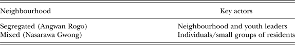
Information dissemination and mobilisation in mixed neighbourhoods followed a slightly different pattern. Information was channelled through quotidian networks including families, friends and neighbours. As Table II indicates, neighbourhood and youth leaders had no prominent role in spreading information like those in the segregated settlement. Mobilising residents was also not as centralised here. While residents in segregated neighbourhoods converged at a central point, those in the mixed neighbourhoods clustered across multiple sites, where residents felt safe. Because these were mixed neighbourhoods, the enemy could be one street over or right next door, prompting small groups to convene in front of their homes or at covert corners. Navigating the neighbourhood from one's residence to some central point for mobilisation was unfeasible for fear of being attacked on the way. Co-ethnics living in relatively close proximity met within their immediate vicinity to decide which security measures to take.
Ethnic composition therefore determined whether individuals could mobilise into the large crowds from which armed mobs eventually formed. Those in Angwan Rogo were mobilised to keep threats from coming in by fortifying the settlement's three main entry points. Although the majority of these crowds did not venture out of the neighbourhood, individuals from within formed armed mobs, led by criminals. Some mobs marched about 1.5 kilometres to engage in violence in Ali Kazaure. Most neighbourhood leaders I spoke with seemed unaware of how these mobs came about, but many Ali Kazaure residents recalled how armed groups from the adjoining areas invaded.
By contrast, individuals in ethnically mixed Nasarawa Gwong could only move short distances from home. Navigating the neighbourhood to reach a central point for mobilisation was unfeasible for fear of being attacked en route.Footnote 28 Mobilisation was decentralised, with co-ethnics living relatively close to each other and forming small armed bands to secure their homes and families (see Table III). Their mostly rudimentary weapons included sticks, iron bars and knives. These groups dotted the neighbourhood, rarely venturing farther than their own streets. In one instance, I calculated the distance covered by two of these groups together only added up to about 600 metres.
Table III Points of mobilisation in segregated and mixed neighbourhoods
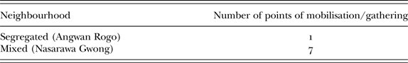
Although in many instances neighbours fought neighbours, a significant – and perhaps deadlier – segment of violence in ethnically mixed Nasarawa Gwong was perpetrated by armed groups from adjoining segregated settlements. Sandwiched between rival segregated groups, the settlement was a frontier where Christian groups from Angwan Rukuba and Tina Junction met Muslim groups from Yan Shanu, Fillin Ball, Dilimi and other adjacent Muslim strongholds. The armed mob from Angwan Rogo marched up to a kilometre from its origin to the confrontation point.
Two findings stand out. First, a large cache of potential rioters, akin to what Brass (Reference Brass2004) called ‘riot systems’ or Berenschot (Reference Berenschot2011) labelled ‘patronage networks’, does not automatically translate into violence; these assemblages need a battleground to be violent. So without a readily available frontier where they can combat other groups, their violent character essentially has no stage. Second, interethnic networks in ethnically mixed areas do not automatically translate into non-violence during riots. What made ethnically mixed areas such as Ali Kazaure and Nasarawa Gwong frontiers was not so much lack of interethnic engagement as pressure by rivalling external groups from the adjoining segregated settlements. Interethnic joint patrols endeavoured to prevent violence in both neighbourhoods, but it was futile in the face of escalating violence and pressure from external forces. The violence prevention networks were not useless, but the location of these settlements between rivalling segregated areas made them highly vulnerable to incursion from outside.
Mixed areas near rivalling segregated neighbourhoods are violence-prone because, first, each group sees them as no-man's land. Like a prize, a mixed area is claimed by those who assert greater dominance. This is common in social conflicts where the very ownership of the city is contested and territorial dominance is a boon to a group's claims of political and social advantages. In this kind of setting, the mixed neighbourhood, especially one sandwiched between rivalling segregated neighbourhoods, becomes a frontier where rivalling groups in the adjoining segregated settlements are perpetually struggling to expand their territorial and political control by displacing rival group members. Second, because of the trans-boundary nature of social networks across the neighbourhoods, armed groups from segregated areas easily find accomplices among their co-ethnics within the mixed area. This dynamic is not unique to Jos; an official report of the 1984 Delhi riots (Tambiah Reference Tambiah1997: 1179) noted that ‘most of the mobs were from areas different from where they operated and only a few local people had joined such mobs to facilitate the operations’.
Further, it is important to ask why armed mobs went after ethnically mixed Ali Kazaure when there were ‘enemy’ populations in other nearby areas. A government-reserved residential area and two University of Jos senior staff quarters (one on Bauchi Road, east of Angwan Rogo, and the other to its north) are about a quarter of a kilometre away – at least four times closer than Ali Kazaure. These areas had many Christians, who could have been attacked by mobs from Angwan Rogo, but they were spared the type of violence experienced in Ali Kazaure. There are two plausible explanations for why this was so. As segregated neighbourhoods, these areas had high levels of collective efficacy and capacity for collective action (Sampson & Groves Reference Sampson and Groves1989). Residents could therefore self-mobilise and, armed with sticks, knives and possibly firearms, many formed a defensive wall. Moreover, these areas were separated by major roads that security forces constantly patrol. I was told about a mob from Angwan Rogo who tried to cross the main Bauchi Road to invade a Christian settlement, but was violently intercepted by security forces. According to reports, some 26 young men, all residents of Angwan Rogo, were killed in that incident (Human Rights Watch 2009). However, the neighbourhood's leaders told me the men were only observing what was happening across the road, where a sizeable Christian mob was forming. What really happened that Saturday morning may remain unproven, but what is certain is that the security forces applied disproportionate force in dealing with the situation and Bauchi Road proved costlier to the mobs than the back roads. The government residential area and the university staff quarters were fortunate because, as Krause (Reference Krause2017: 265) points out, middle-class areas ‘generally receive more police protection and are much easier to police than overcrowded slum areas with very poor street infrastructure’.
The type of neighbourhood most likely to experience violence during riots, therefore, is an ethnically mixed neighbourhood that is sandwiched between rivalling segregated settlements. However, it is far more likely to be invaded by armed mobs if it is contiguously connected to the segregated settlements through back roads that are inaccessible to security forces and outsiders. Armed mobs’ penchant for narrow, hidden-away routes was also demonstrated by Christians from Angwan Rukuba who invaded parts of Nasarawa Gwong.
CONCLUSION
The literature has presented conflicting evidence on how ethnic segregation and diversity are related to collective violence. This article argues that some of this ambivalence stems from assumptions about the mobile nature of armed mobs and its implications for the spread of violence. This study shows how the origins of armed mobs are not the same as the locations of their violence. I demonstrated this by walking in the footsteps of rioters within and across neighbourhood boundaries. Contrary to the determinist stance currently dominating ethnic composition and violence debates, both ethnically segregated and mixed neighbourhoods contribute to the production of violence, albeit differently. While segregated localities are suitable for mobilising armed mobs, diverse areas, especially those located between segregated settlements, are wont to violent clashes.
As for these findings’ implications, I begin by emphasising that armed mobs are more easily mobilised in ethnically segregated areas, yet they need a battleground to engage in violence. An adjoining ethnically mixed settlement, especially if it shares parts of its boundary with another segregated settlement inhabited by a rival group, provides an apt frontier for confrontation. Such ethnically mixed areas lack the cohesiveness to mobilise against external forces. Even when they organise joint patrols to keep troublemakers out, such efforts prove futile in the face of escalating violence and determined external armed mobs. Thus, although homogenously segregated neighbourhoods may not experience violence, they do contribute to violence in the adjoining areas. Moreover, though ethnically mixed areas may be the sites of recurrent violence, they may not always be home to the fighters. It is pertinent, therefore, to also consider how neighbourhoods contribute to violence rather than only focus, as certain studies have done, on whether they are violent or not.
Understanding how localities contribute to the production of violence reveals major undercurrents, which the conventional dichotomous categorisation of neighbourhoods as violent versus non-violent ignores. By seeing the segregated settlement as the supplier of fighters and the ethnically mixed area next to it as the frontier hosting the opportunity to fight, we recognise how both settings are involved in the outbreak and spread of violence; we also see how the absence of either can alter the dynamics of violence dramatically. Further, understanding the shared boundaries of localities and how they enhance or impede rioters’ mobility helps explain the spread of violence. By walking in the footsteps of rioters, I got a more grounded, clearer grasp of the factors shaping their spatial behaviour. This complements and enriches non-spatial conceptions of the dynamics of collective violence. It can ultimately advance our understanding of the factors that shape levels and patterns of violence in urban environments.
From a policy perspective, understanding the processes and conditions under which individuals become armed mobs, their preferred routes and the areas where violence is most likely to occur can contribute to the management of violence. While it is beyond this article's scope to provide indicators for predicting violence, the overarching objective was to identify rioters’ spatial behaviour in different settings. Understanding that residents’ and youth association leaders play more prominent roles in information-sharing and mobilisation in segregated settlements than mixed settings is valuable; it can give authorities clues concerning who to focus on and work with to prevent violence. Advance knowledge of rioters’ preferred routes and likely-to-target neighbourhoods can encourage more proactive responses, thus containing fighters before large-scale violence breaks out.
These findings, emerging from an ethnography of Jos, should prove interesting and perhaps worth re-examining to determine how far they reflect the reality of other cities with similar struggles. This could be challenging considering the paucity of disaggregated micro-level data. It may be feasible, though, in cities with census tracts down to neighbourhood or street levels, as well as detailed records of arrests, addresses of perpetrators, incident locations and CCTV footage.


 Open access