Have Historical Land Use/Land Cover Changes Triggered a Fire Regime Shift in Central Spain?

 ,
,  , , ,
, , ,
Abstract
:1. Introduction
2. Materials and Methods
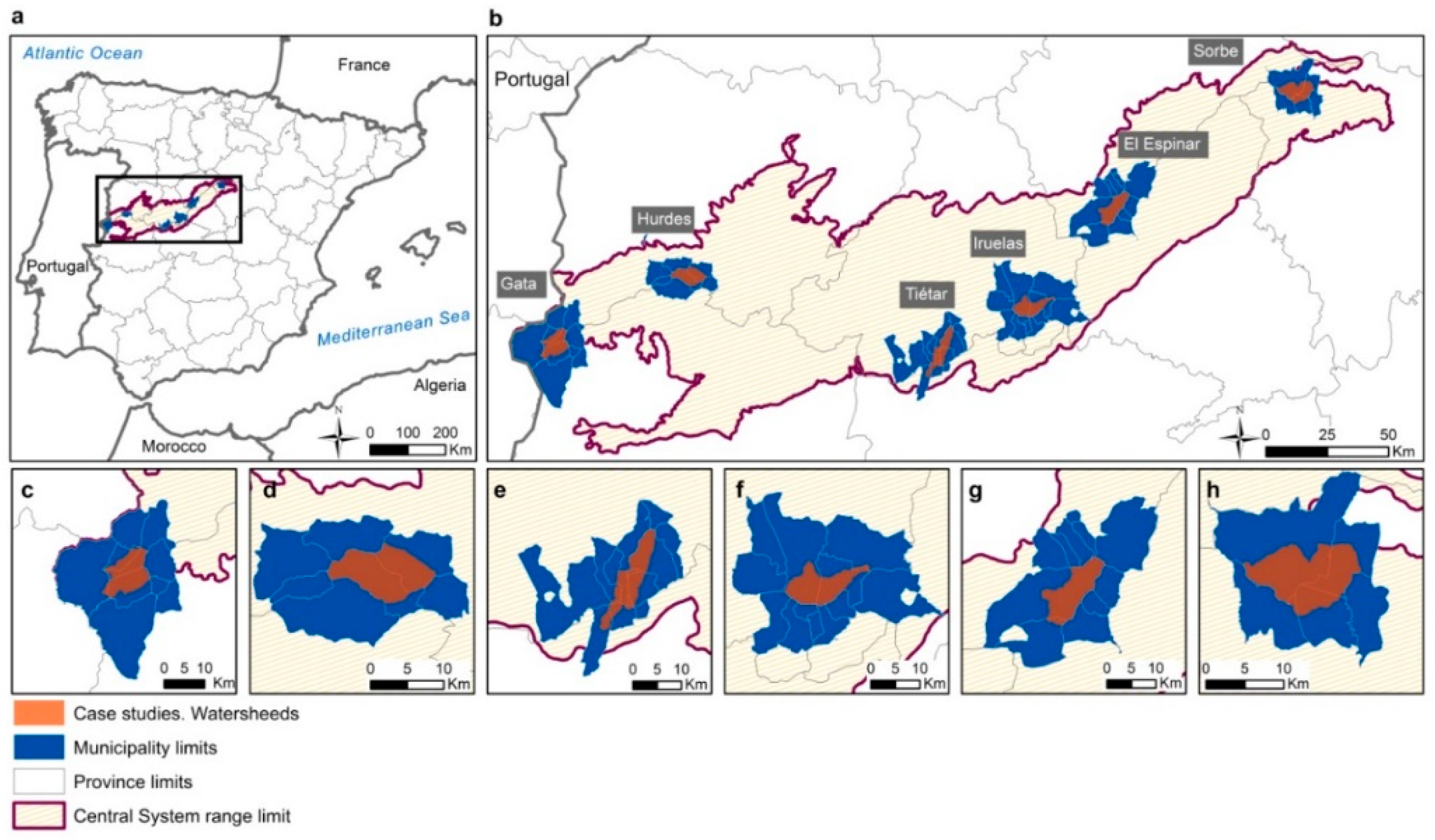
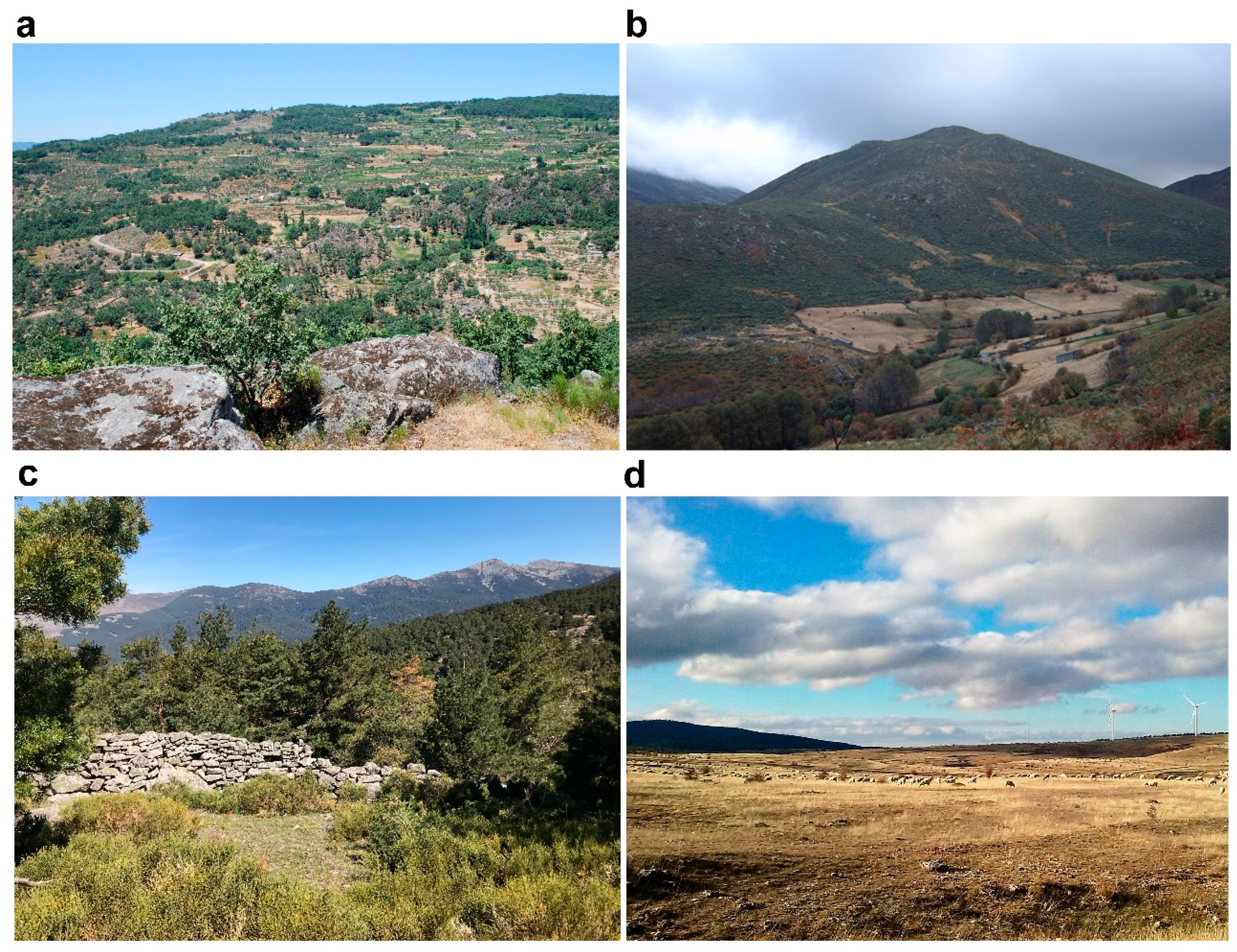
2.1. Case Studies
2.2. Material: Geohistorical Sources, Statistics, and Geospatial Data
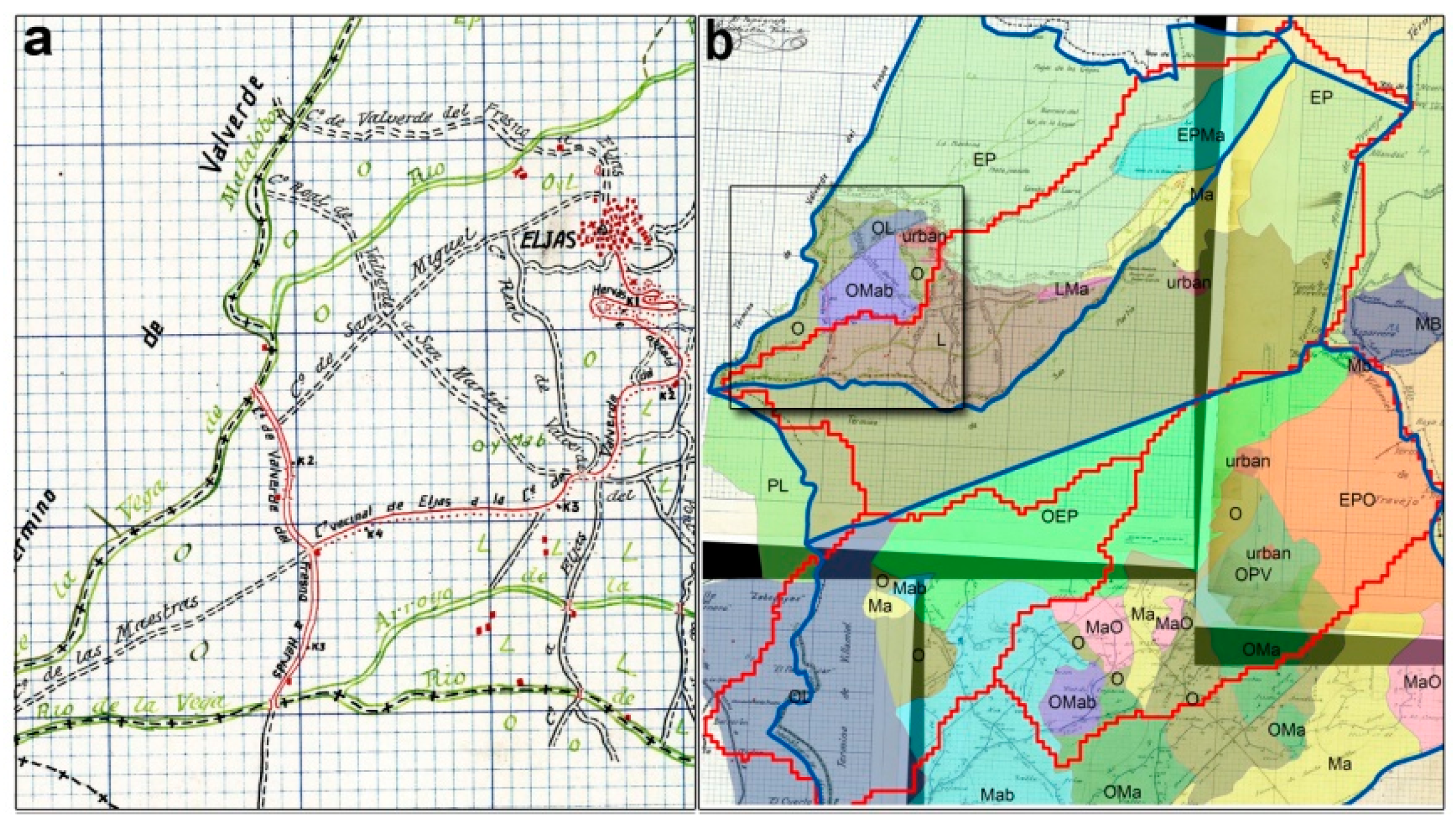
2.2.1. Historical Cartography
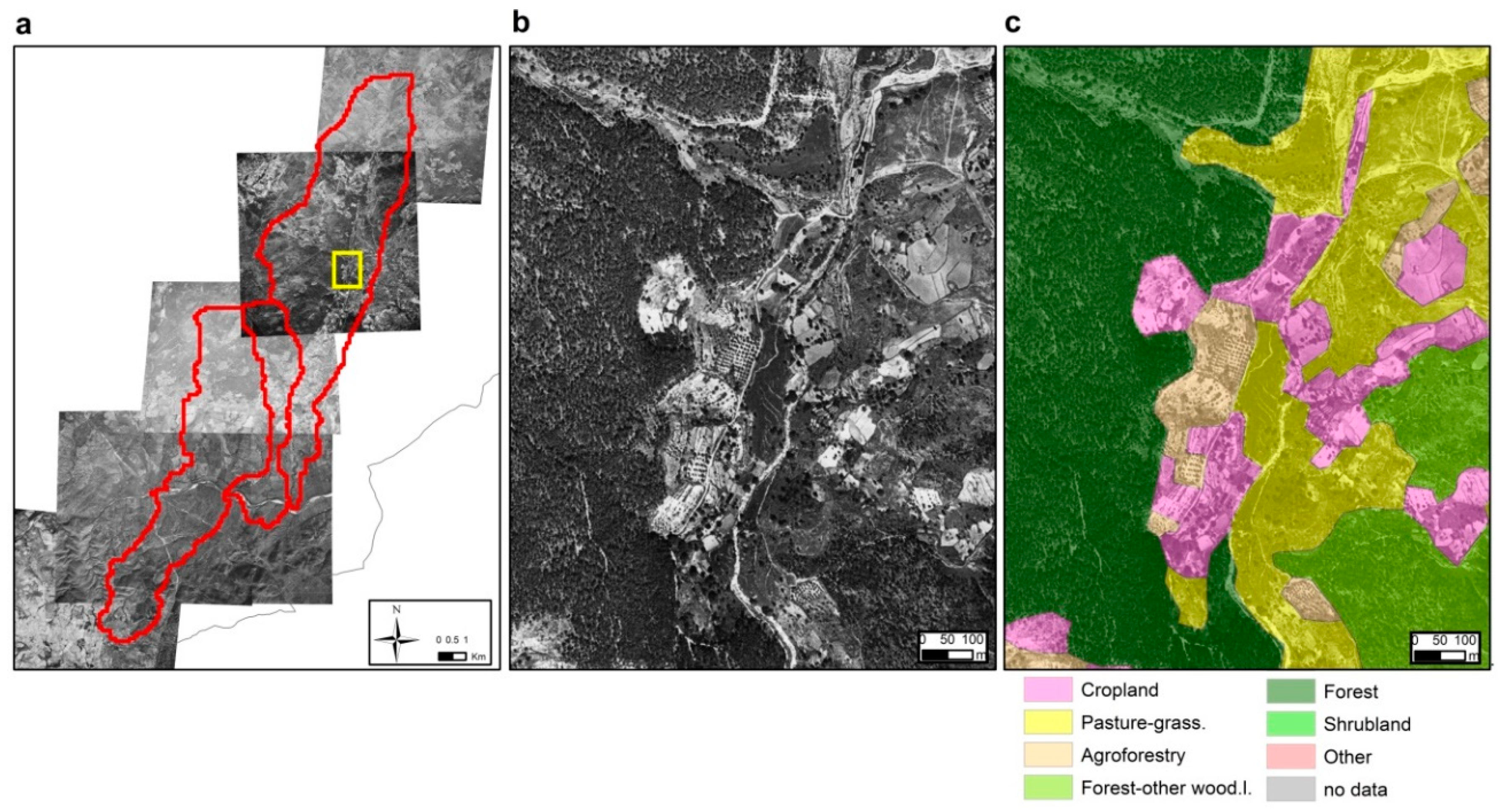
2.2.2. Aerial Photography
2.2.3. Geospatial Data
2.2.4. UCM Fire History Dataset
2.2.5. Statistical Fire Data
2.3. Methodology
2.3.1. Historical LULC Mapping
2.3.2. Fire History Reconstruction
2.3.3. Integrated Assessment of the Interactions between LULC Changes and Fire History at the Local Scale
3. Results
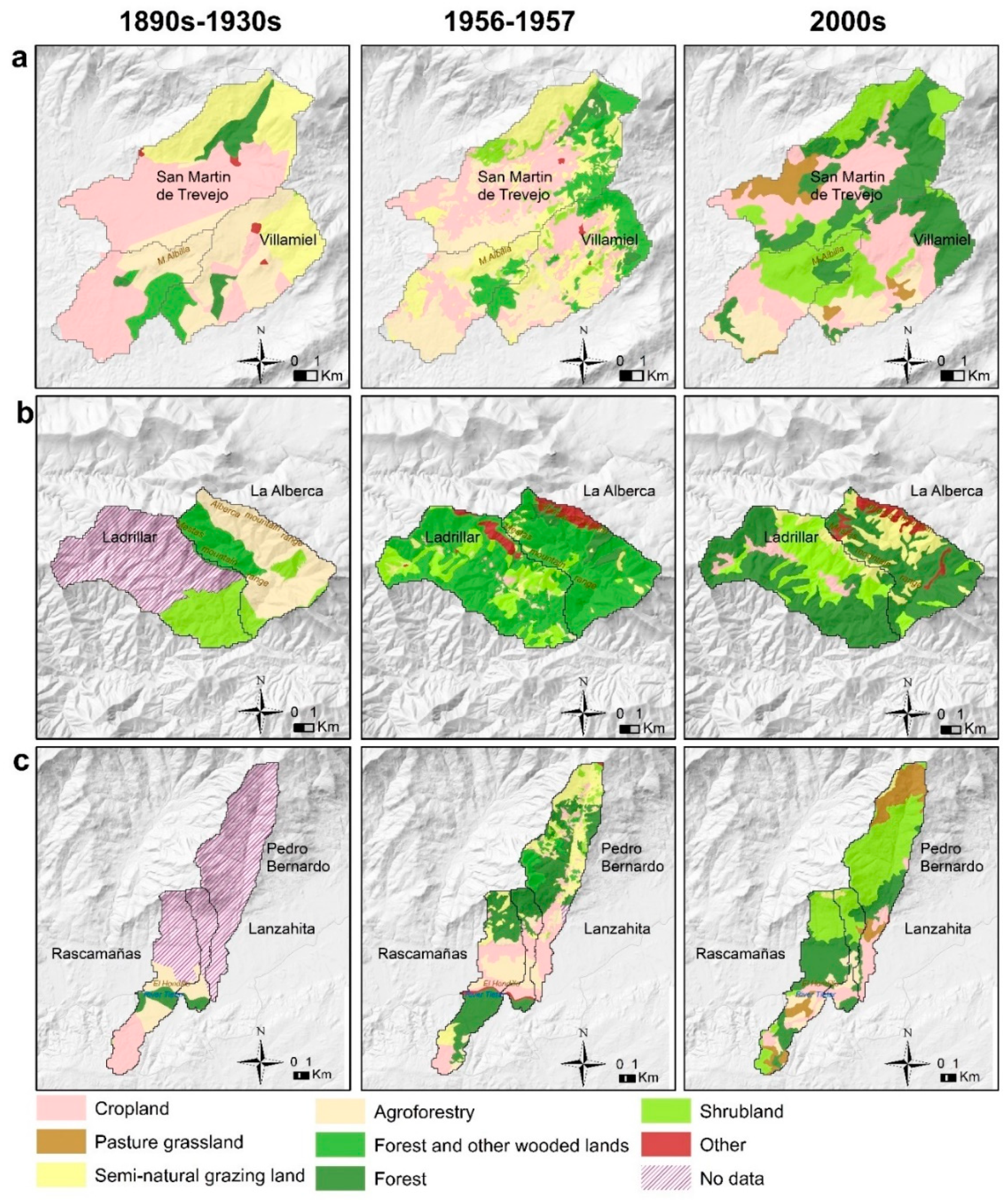
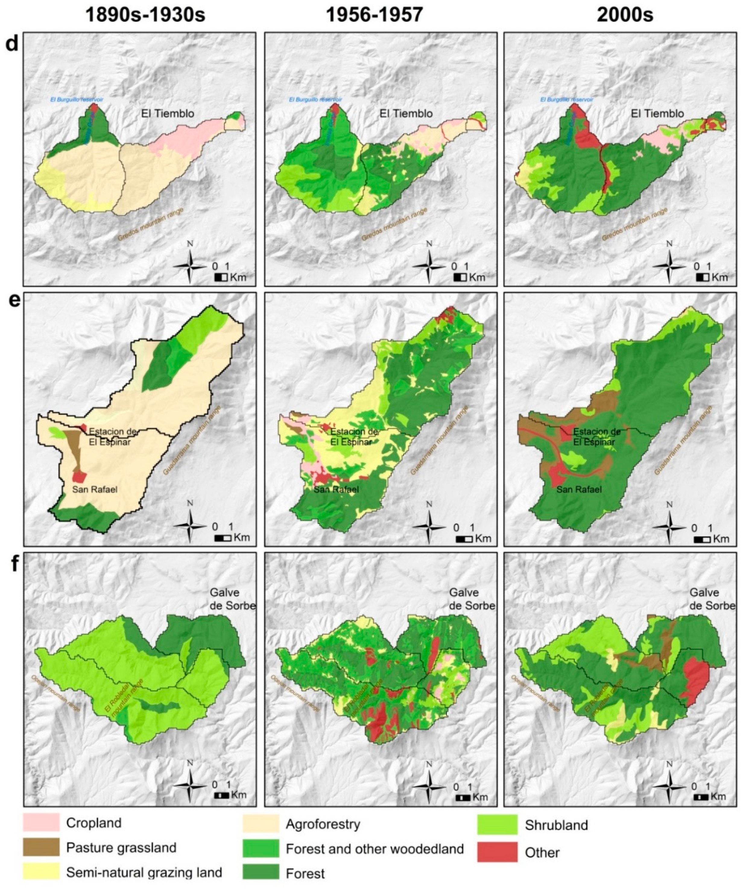
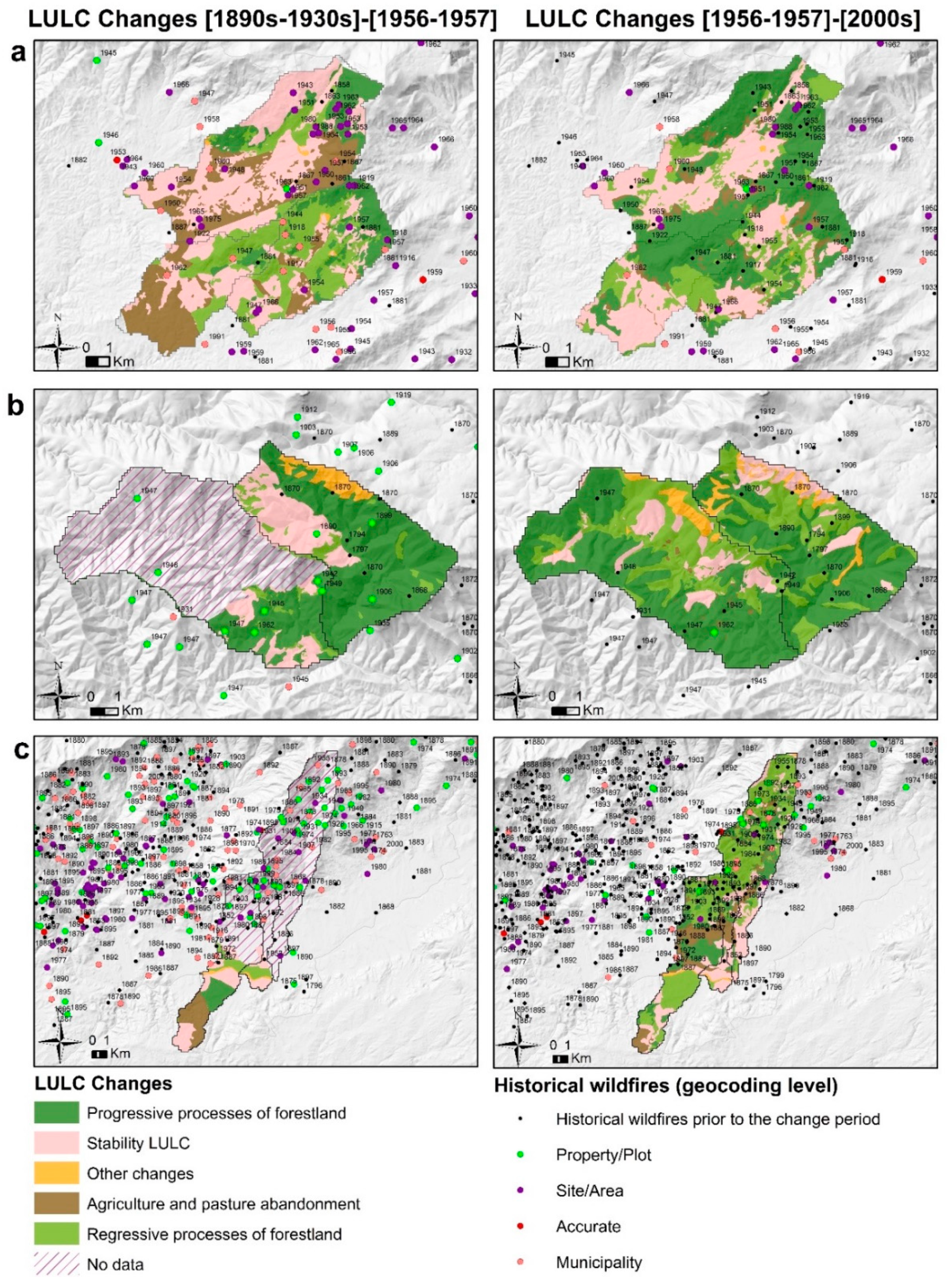
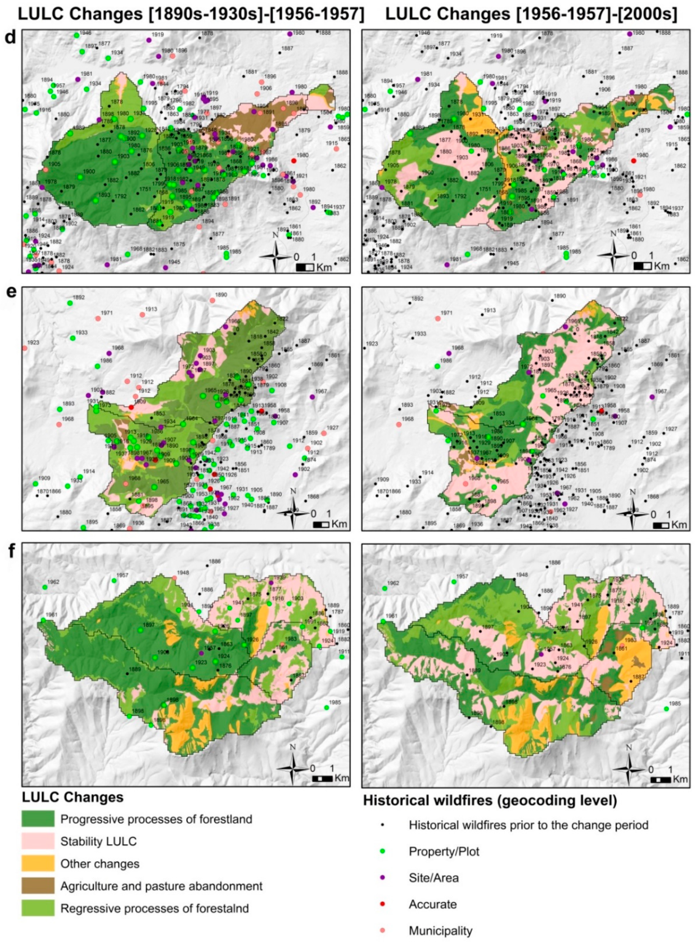
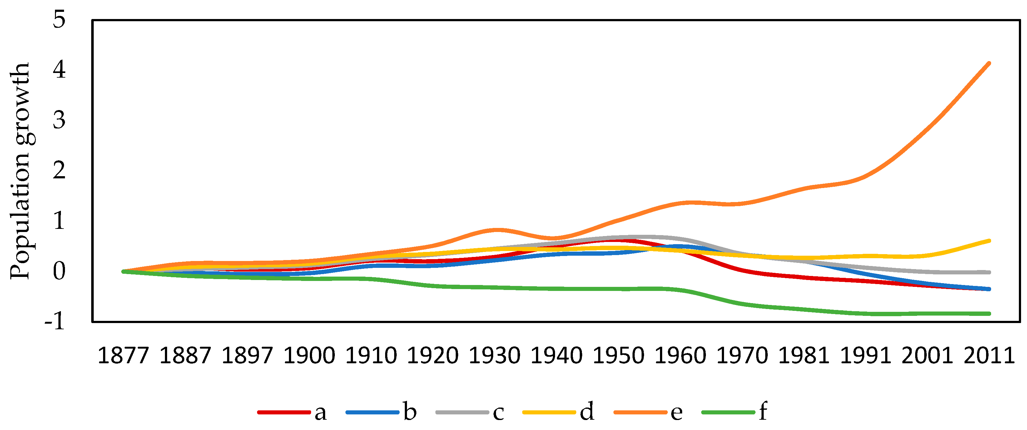
3.1. Historical Land Use/Land Cover Reconstruction
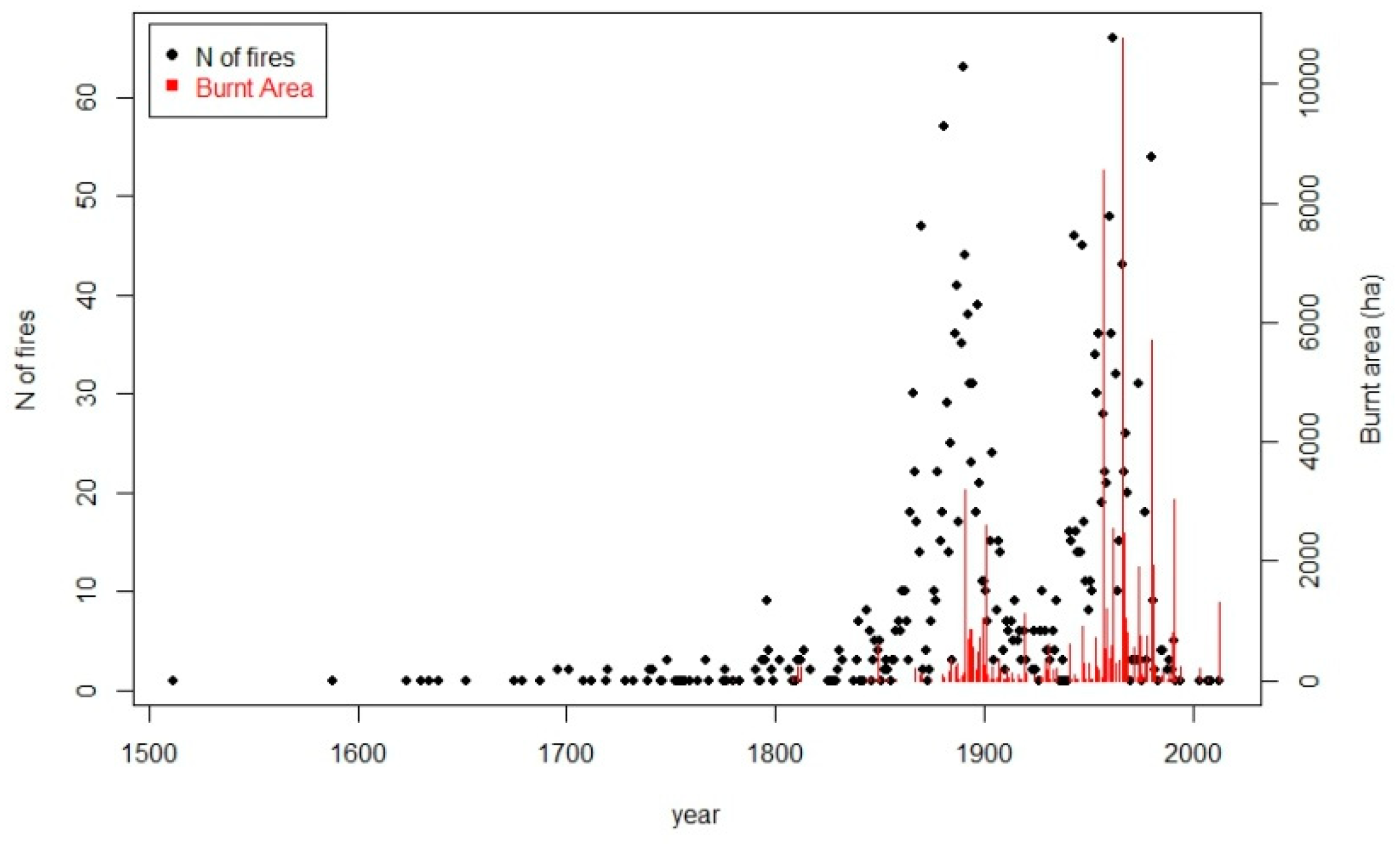
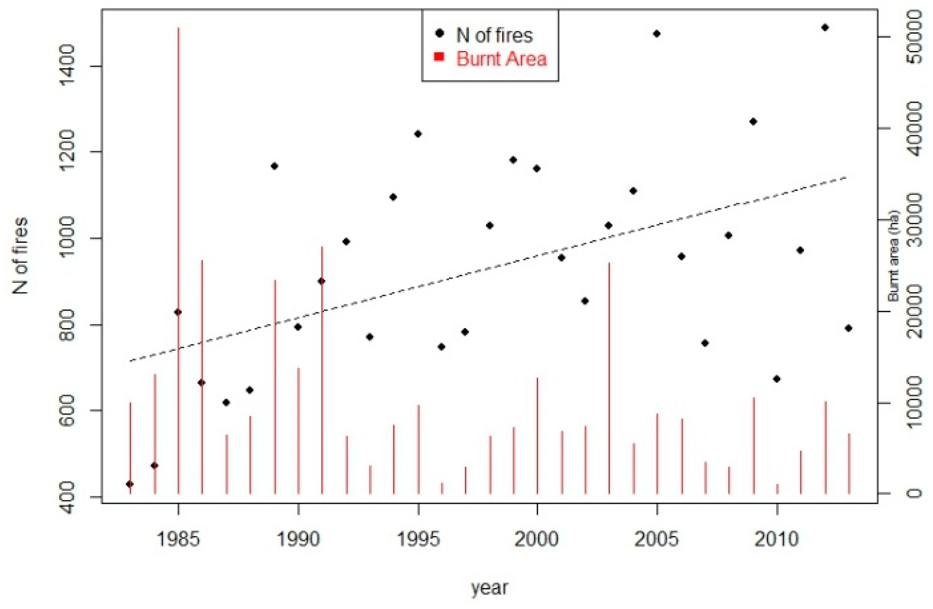
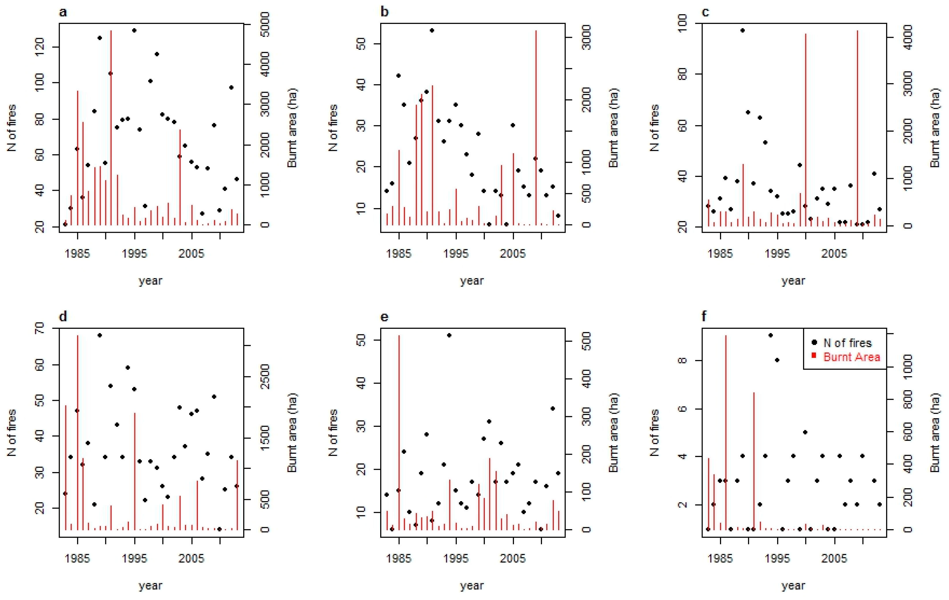
3.2. Fire History Reconstruction
3.3. Spatiotemporal Patterns of Land Use/Land Cover Changes and Fire Occurrence
4. Discussion
5. Conclusions
Author Contributions
Funding
Acknowledgments
Conflicts of Interest
References
- Beilin, R.; West, S. Performing natures: Adaptive management practice in ‘the eternally unfolding present. In Nature, Temporality and Environmental Management; Head, L., Saltzman, K., Setten, G., Stenseke, M., Eds.; Routledge: London, UK; New York, NY, USA, 2017; pp. 186–203. [Google Scholar]
- McWethy, D.B.; Pauchard, A.; García, R.A.; Holz, A.; González, M.E.; Veblen, T.T.; Stahl, J.; Currey, B. Landscape drivers of recent fire activity (2001–2017) in south-central Chile. PLoS ONE 2018, 13, e0201195. [Google Scholar] [CrossRef] [PubMed]
- Molina, C.M.; Galiana-Martín, L. Fire Scenarios in Spain: A Territorial Approach to Proactive Fire Management in the Context of Global Change. Forests 2016, 7, 273. [Google Scholar] [CrossRef]
- Turner, M.G. Disturbance and landscape dynamics in a changing world. Ecology 2010, 91, 2833–2849. [Google Scholar] [CrossRef] [PubMed] [Green Version]
- Castellnou, M.; Miralles, M. The great fire changes in the Mediterranean—The example of Catalonia, Spain. Crisis Response 2009, 5, 56–57. [Google Scholar]
- Mermoz, M.; Kitzberger, T.; Veblen, T.T. Landscape influences on occurrence and spread of wildfires in patagonian forests and shrublands. Ecology 2005, 86, 2705–2715. [Google Scholar] [CrossRef]
- Ferrara, C.; Salvati, L.; Corona, P.; Romano, R.; Marchi, M. The background context matters: Local-scale socioeconomic conditions and the spatial distribution of wildfires in Italy. Sci. Total. Environ. 2019, 654, 43–52. [Google Scholar] [CrossRef] [PubMed]
- Molina, C.M.; Martín, O.K.; Martín, L.G. Regional fire scenarios in Spain: Linking landscape dynamics and fire regime for wildfire risk management. J. Environ. Manag. 2019, 233, 427–439. [Google Scholar] [CrossRef]
- Saladyga, T.; Standlee, A. Historical Drivers and Contemporary Perceptions of Wildfire in a Post-Industrial Rural Landscape. Fire 2018, 1, 33. [Google Scholar] [CrossRef]
- Brown, P.M.; Kaufmann, M.R.; Shepperd, W.D. Long-term, landscape patterns of past fire events in a montane ponderosa pine forest of central Colorado. Landsc. Ecol. 1999, 14, 513–532. [Google Scholar] [CrossRef]
- Swetnam, T.W. Fire History and Climate Change in Giant Sequoia Groves. Science 1993, 262, 885–889. [Google Scholar] [CrossRef]
- Acácio, V.; Holmgren, M.; Rego, F.; Moreira, F.; Mohren, G.M.J. Are drought and wildfires turning Mediterranean cork oak forests into persistent shrublands? Agrofor. Syst. 2009, 76, 389–400. [Google Scholar] [CrossRef]
- Abel-Schaad, D.; López-Sáez, J.A. Vegetation changes in relation to fire history and human activities at the Peña Negra mire (Bejar Range, Iberian Central Mountain System, Spain) during the past 4,000 years. Veg. Hist. Archaeobotany 2013, 22, 199–214. [Google Scholar] [CrossRef]
- López-Sáez, J.A.; Abel-Schaad, D.; Pérez-Díaz, S.; Blanco-González, A.; Alba-Sánchez, F.; Dorado, M.; Ruiz-Zapata, B.; Gil-García, M.J.; Gómez-González, C.; Franco-Múgica, F. Vegetation history, climate and human impact in the Spanish Central System over the last 9000 years. Quat. Int. 2014, 353, 98–122. [Google Scholar] [CrossRef]
- López-Sáez, J.A.; Abel-Schaad, D.; Robles-López, S.; Pérez-Díaz, S.; Alba-Sánchez, F.; Lugilde, D.N. Landscape dynamics and human impact on high-mountain woodlands in the western Spanish Central System during the last three millennia. J. Archaeol. Sci. Rep. 2016, 9, 203–218. [Google Scholar] [CrossRef]
- López-Sáez, J.A.; Vargas, G.; Ruiz-Fernández, J.; Blarquez, O.; Alba-Sánchez, F.; Oliva, M.; Pérez-Díaz, S.; Robles-López, S.; Abel-Schaad, D. Paleofire Dynamics in Central Spain during the Late Holocene: The Role of Climatic and Anthropogenic Forcing. Land Degrad. Dev. 2018, 29, 2045–2059. [Google Scholar] [CrossRef]
- Luelmo-Lautenschlaeger, R.; Pérez-Díaz, S.; Alba-Sánchez, F.; Abel-Schaad, D.; López-Sáez, J.A. Vegetation History in the Toledo Mountains (Central Iberia): Human Impact during the Last 1300 Years. Sustainability 2018, 10, 2575. [Google Scholar] [CrossRef]
- Morales-Molino, C.; Colombaroli, D.; Valbuena-Carabaña, M.; Tinner, W.; Salomón, R.L.; Carrión, J.S.; Gil, L. Land-use history as a major driver for long-term forest dynamics in the Sierra de Guadarrama National Park (central Spain) during the last millennia: Implications for forest conservation and management. Glob. Planet. Chang. 2017, 152, 64–75. [Google Scholar] [CrossRef]
- Robles-López, S.; Pérez-Díaz, S.; Ruiz-Alonso, M.; Blarquez, O.; Luelmo-Lautenschlaeger, R.; López-Sáez, J.A. Holocene vegetation and fire dynamics in the supra-Mediterranean belt of the Gredos Range (central Iberian Peninsula). Plant Biosyst. 2019, 1–13. [Google Scholar] [CrossRef]
- Morales-Molino, C.; Colombaroli, D.; Tinner, W.; Perea, R.; Valbuena-Carabaña, M.; Carrión, J.S.; Gil, L. Vegetation and fire dynamics during the last 4000 years in the Cabañeros National Park (central Spain). Rev. Palaeobot. Palynol. 2018, 253, 110–122. [Google Scholar] [CrossRef]
- Beffa, G.; Pedrotta, T.; Colombaroli, D.; Henne, P.D.; van Leeuwen, J.F.N.; Süsstrunk, P.; Kaltenrieder, P.; Adolf, C.; Vogel, H.; Pasta, S.; et al. Vegetation and fire history of coastal north-eastern Sardinia (Italy) under changing Holocene climates and land use. Veg. Hist. Archaeobotany 2016, 25, 271–289. [Google Scholar] [CrossRef]
- Bebi, P.; Seidl, R.; Motta, R.; Fuhr, M.; Firm, D.; Krumm, F.; Conedera, M.; Ginzler, C.; Wohlgemuth, T.; Kulakowski, D. Changes of forest cover and disturbance regimes in the mountain forests of the Alps. For. Ecol. Manag. 2017, 388, 43–56. [Google Scholar] [CrossRef] [PubMed]
- Meneses, B.M.; Reis, E.; Reis, R. Assessment of the recurrence interval of wildfires in mainland Portugal and the identification of affected LUC patterns. J. Maps 2018, 14, 282–292. [Google Scholar] [CrossRef]
- Carlucci, M.; Zambon, I.; Colantoni, A.; Salvati, L. Socioeconomic Development, Demographic Dynamics and Forest Fires in Italy, 1961–2017: A Time-Series Analysis. Sustainability 2019, 11, 1305. [Google Scholar] [CrossRef]
- Conedera, M.; Krebs, P.; Valese, E.; Cocca, G.; Schunk, C.; Menzel, A.; Vacik, H.; Cane, D.; Japelj, A.; Muri, B.; et al. Characterizing Alpine pyrogeography from fire statistics. Appl. Geogr. 2018, 98, 87–99. [Google Scholar] [CrossRef]
- Koutsias, N.; Martínez-Fernández, J.; Allgöwer, B. Do Factors Causing Wildfires Vary in Space? Evidence from Geographically Weighted Regression. GISci. Remote Sens. 2010, 47, 221–240. [Google Scholar] [CrossRef]
- Mancini, L.D.; Corona, P.; Salvati, L. Ranking the importance of Wildfires’ human drivers through a multi-model regression approach. Environ. Impact Assess. Rev. 2018, 72, 177–186. [Google Scholar] [CrossRef]
- Moreno, M.V.; Conedera, M.; Chuvieco, E.; Pezzatti, G.B. Fire regime changes and major driving forces in Spain from 1968 to 2010. Environ. Sci. Policy 2014, 37, 11–22. [Google Scholar] [CrossRef]
- Rodrigues, M.; De La Riva, J.; Fotheringham, S. Modeling the spatial variation of the explanatory factors of human-caused wildfires in Spain using geographically weighted logistic regression. Appl. Geogr. 2014, 48, 52–63. [Google Scholar] [CrossRef]
- Silva, J.M.N.; Moreno, M.V.; Le Page, Y.; Oom, D.; Bistinas, I.; Pereira, J.M.C. Spatiotemporal trends of area burnt in the Iberian Peninsula, 1975–2013. Reg. Environ. Chang. 2019, 19, 515–527. [Google Scholar] [CrossRef]
- Viedma, O.; Moity, N.; Moreno, J.M. Changes in landscape fire-hazard during the second half of the 20th century: Agriculture abandonment and the changing role of driving factors. Agric. Ecosyst. Environ. 2015, 207, 126–140. [Google Scholar] [CrossRef]
- Nogueira, D.F.; Rico, E.C. Cambios en los usos de suelo en la Península Ibérica: Un meta-análisis para el período, 1985–2015. In Biblio3W Revista Bibliográfica de Geografía y Ciencias Sociales; Universitat de Barcelona: Barcelona, Spain, 2017; Volume XXII. [Google Scholar]
- Fuchs, R.; Herold, M.; Verburg, P.H.; Clevers, J.G.P.W.; Eberle, J. Gross changes in reconstructions of historic land cover/use for Europe between 1900 and 2010. Glob. Chang. Biol. 2015, 21, 299–313. [Google Scholar] [CrossRef] [PubMed]
- Pinto-Correia, T.; Primdahl, J.; Pedroli, B. European Landscapes in Transition: Implications for Policy and Practice; Cambridge University Press: Cambridge, UK, 2018. [Google Scholar] [CrossRef]
- Plieninger, T.; Draux, H.; Fagerholm, N.; Bieling, C.; Bürgi, M.; Kizos, T.; Kuemmerle, T.; Primdahl, J.; Verburg, P.H. The driving forces of landscape change in Europe: A systematic review of the evidence. Land Use Policy 2016, 57, 204–214. [Google Scholar] [CrossRef] [Green Version]
- Barbier, E.B.; Burgess, J.C.; Grainger, A. The forest transition: Towards a more comprehensive theoretical framework. Land Use Policy 2010, 27, 98–107. [Google Scholar] [CrossRef]
- Perz, S.G. Grand Theory and Context-Specificity in the Study of Forest Dynamics: Forest Transition Theory and Other Directions. Prof. Geogr. 2007, 59, 105–114. [Google Scholar] [CrossRef]
- Rudel, T.K.; Coomes, O.T.; Moran, E.; Achard, F.; Angelsen, A.; Xu, J.; Lambin, E. Forest transitions: Towards a global understanding of land use change. Glob. Environ. Chang. 2005, 15, 23–31. [Google Scholar] [CrossRef]
- Cramer, V.A.; Hobbs, R. Old Fields: Dynamics of Restoration of Abandoned Farmland; Island Press: Washington, DC, USA, 2007. [Google Scholar]
- Otero, I.; Marull, J.; Tello, E.; Diana, G.L.; Pons, M.; Coll, F.; Boada, M. Land abandonment, landscape, and biodiversity: Questioning the restorative character of the forest transition in the Mediterranean. Ecol. Soc. 2015, 20. [Google Scholar] [CrossRef]
- Varga, D.; Subirós, J.V.; Barriocanal, C.; Pujantell, J. Landscape Transformation under Global Environmental Change in Mediterranean Mountains: Agrarian Lands as a Guarantee for Maintaining Their Multifunctionality. Forests 2018, 9, 27. [Google Scholar] [CrossRef]
- Vadell, E.; De Miguel, S.; Pemán, J. Large-scale reforestation and afforestation policy in Spain: A historical review of its underlying ecological, socioeconomic and political dynamics. Land Use Policy 2016, 55, 37–48. [Google Scholar] [CrossRef]
- Marey-Pérez, M.; Rodríguez-Vicente, V. Forest transition in Northern Spain: Local responses on large-scale programmes of field-afforestation. Land Use Policy 2009, 26, 139–156. [Google Scholar] [CrossRef]
- Iriarte-Goñi, I.; Ayuda, M.-I. Should Forest Transition Theory include effects on forest fires? The case of Spain in the second half of the twentieth century. Land Use Policy 2018, 76, 789–797. [Google Scholar] [CrossRef]
- Antrop, M. Landscape change and the urbanization process in Europe. Landsc. Urban Plan. 2004, 67, 9–26. [Google Scholar] [CrossRef]
- Tsilimigkas, G.; Kizos, T.; Gourgiotis, A. Unregulated urban sprawl and spatial distribution of fire events: Evidence from Greece. Environ. Hazards 2018, 17, 436–455. [Google Scholar] [CrossRef]
- Galiana-Martín, L. Spatial Planning Experiences for Vulnerability Reduction in the Wildland-Urban Interface in Mediterranean European Countries. Eur. Ctry. 2017, 9, 577–593. [Google Scholar] [CrossRef] [Green Version]
- Kander, A.; Malanima, P.; Warde, P. Power to the People Energy in Europe over the Last Five Centuries; Princeton University Press: Princeton, NJ, USA, 2013. [Google Scholar]
- Hernando Ortego, J.; Madrazo García de Lomana, G. Firewood and Charcoal Consumption in Madrid during Eighteenth Century and Its Effects on Forest Landscapes. In Environmental History in the Making; Volume I: Explaining; Vaz, E., Joanaz de Melo, C., Costa Pinto, L.M., Eds.; Springer International Publishing: Cham, Switzerland, 2017; pp. 321–340. [Google Scholar] [CrossRef]
- Iriarte-Goñi, I.; Infante-Amate, J. Continuity, change, and geographical differences in Spain’s firewood consumption: A new estimation (1860–2010). Hist. Agrar. 2019, 77, 33–57. [Google Scholar] [CrossRef]
- Warde, P. Firewood consumption and energy transition: A survey of sources, methods and explanations in Europe and North America. Hist. Agrar. 2019, 77, 7–32. [Google Scholar] [CrossRef]
- Costa, P.; Castellnou, M.; Larrañaga, A.; Miralles, M.; Kraus, D. Prevention of Large Wildfires Using the Fire Types Concept; UT GRAF-Generalitat de Catalunya: Barcelona, Spain, 2011. [Google Scholar]
- Loepfe, L.; Martinez-Vilalta, J.; Oliveres, J.; Piñol, J.; Lloret, F. Feedbacks between fuel reduction and landscape homogenisation determine fire regimes in three Mediterranean areas. For. Ecol. Manag. 2010, 259, 2366–2374. [Google Scholar] [CrossRef]
- Moreira, F.; Viedma, O.; Arianoutsou, M.; Curt, T.; Koutsias, N.; Rigolot, E.; Barbati, A.; Corona, P.; Vaz, P.; Xanthopoulos, G.; et al. Landscape—Wildfire interactions in southern Europe: Implications for landscape management. J. Environ. Manag. 2011, 92, 2389–2402. [Google Scholar] [CrossRef]
- Valese, E.; Conedera, M.; Held, A.; Ascoli, D. Fire, humans and landscape in the European Alpine region during the Holocene. Anthropocene 2014, 6, 63–74. [Google Scholar] [CrossRef]
- Ricotta, C.; Bajocco, S.; Guglietta, D.; Conedera, M. Assessing the Influence of Roads on Fire Ignition: Does Land Cover Matter? Fire 2018, 1, 24. [Google Scholar] [CrossRef]
- Chergui, B.; Fahd, S.; Santos, X.; Pausas, J.G. Socioeconomic Factors Drive Fire-Regime Variability in the Mediterranean Basin. Ecosystems 2018, 21, 619–628. [Google Scholar] [CrossRef]
- Pausas, J.G.; Fernández-Muñoz, S. Fire regime changes in the Western Mediterranean Basin: From fuel-limited to drought-driven fire regime. Clim. Chang. 2012, 110, 215–226. [Google Scholar] [CrossRef]
- Costafreda-Aumedes, S.; Comas, C.; Vega-Garcia, C. Spatio-Temporal Configurations of Human-Caused Fires in Spain through Point Patterns. Forests 2016, 7, 185. [Google Scholar] [CrossRef]
- Ricotta, C.; Di Vito, S. Modeling the Landscape Drivers of Fire Recurrence in Sardinia (Italy). Environ. Manag. 2014, 53, 1077–1084. [Google Scholar] [CrossRef] [PubMed]
- Bajocco, S.; Ferrara, C.; Guglietta, D.; Ricotta, C. Fifteen years of changes in fire ignition frequency in Sardinia (Italy): A rich-get-richer process. Ecol. Indic. 2019, 104, 543–548. [Google Scholar] [CrossRef]
- Viedma, O.; Moreno, J.M.; Güngöroglu, C.; Cosgun, U.; Kavgacı, A. Recent land-use and land-cover changes and its driving factors in a fire-prone area of southwestern Turkey. J. Environ. Manag. 2017, 197, 719–731. [Google Scholar] [CrossRef] [PubMed]
- Mazzoleni, S.; de Pasquale, G.; Mulligan, M.; di Martino, P.; Rego, F. Recent Dynamics of the Mediterranean Vegetation and Landscape; Wiley: Chichester, UK, 2004. [Google Scholar]
- Antrop, M. Why landscapes of the past are important for the future. Landsc. Urban Plan. 2005, 70, 21–34. [Google Scholar] [CrossRef]
- Camarero, J.J.; Sangüesa-Barreda, G.; Pérez-Díaz, S.; Montiel-Molina, C.; Seijo, F.; López-Sáez, J.A. Abrupt regime shifts in post-fire resilience of Mediterranean mountain pinewoods are fuelled by land use. Int. J. Wildland Fire 2019, 28, 329–341. [Google Scholar] [CrossRef]
- Montiel Molina, C. La presencia histórica del fuego en el territorio. In Ecología de la Regeneración de Zonas Incendiadas; García Novo, F., Casal, M., Pausas, J.G., Eds.; Academia de Ciencias Sociales y Medio Ambiente de Andalucía: Sevilla, Spain, 2018. [Google Scholar]
- Hinderink, J. The Sierra de Gata: A Geographical Study of a Rural Mountain Area in Spain; JB Wolters: Groningen, The Netherlands, 1963. [Google Scholar]
- Legendre, M. Las Jurdes. Étude de Géographie Humaine; E. de Boccard: Paris, France; Feret & Fils: Bordeaux, France, 1927. [Google Scholar]
- Jordana;Morera, J. Memoria de Reconocimiento del Monte de la Garganta de los Propios de El Espinar; Junta de Castilla y León: Valladolid, Spain, 1862. [Google Scholar]
- Martínez García, F. ¿Qué valor tiene el argumento de las «repoblaciones antiguas»?: El ejemplo de los pinares albares del Sistema Central. Anales de Biología 2002, 24, 45–63. [Google Scholar]
- Fernández Muñoz, S. Consecuencias socioeconómicas y territoriales de las repoblaciones forestales en el Alto Sorbe (Guadalajara). Ería 2002, 58, 183–204. [Google Scholar]
- Lepart, J.; Debussche, M. Human Impact on Landscape Patterning: Mediterranean Examples. In Landscape Boundaries. Ecological Studies (Analysis and Synthesis); Hansen, A.J., di Castri, F., Eds.; Springer: New York, NY, USA, 1992; Volume 92. [Google Scholar]
- Carreras, A.; Tafunell, X. Estadísticas Históricas de España, Siglos XIX-XX; Fundación BBVA: Bilbao, Spain, 2006. [Google Scholar]
- Camarero, L. Del Éxodo Rural y del Éxodo Urbano. Ocaso y Renacimiento de los Asentamientos Rurales en España; Ministerio de Agricultura, Pesca y Alimentación: Madrid, Spain, 1993.
- European Union. Consolidated Version of the Treaty on the Functioning of the European Union In 2008/C 115/01. Available online: https://www.refworld.org/docid/4b17a07e2.html (accessed on 3 August 2019).
- Lefebvre, M.; Espinosa, M.; Gomez y Paloma, S. The influence of the Common Agricultural Policy on agricultural landscapes EUR 25459 EN; European Commission, Joint Research Centre, Institute for Prospective Technological Studies Luxembourg; Publications Office of the European Union: Luxembourg, 2012. [Google Scholar]
- Rifa, A.; Castellnou, M. El modelo de extinción de incendios forestales catalan. In Proceedings of the IV International Wildfire Fire Conference, Seville, Spain, 14–17 May 2007. [Google Scholar]
- Syphard, A.D.; Keeley, J.E. Historical reconstructions of California wildfires vary by data source. Int. J. Wildland Fire 2016, 25, 1221–1227. [Google Scholar] [CrossRef]
- Pereira, M.G.; Malamud, B.D.; Trigo, R.M.; Alves, P.I.; Trigo, R. The history and characteristics of the 1980–2005 Portuguese rural fire database. Nat. Hazards Earth Syst. Sci. 2011, 11, 3343–3358. [Google Scholar] [CrossRef]
- Keeley, J.E.; Syphard, A.D. Historical patterns of wildfire ignition sources in California ecosystems. Int. J. Wildland Fire 2018, 27, 781–799. [Google Scholar] [CrossRef]
- Ganteaume, A.; Camia, A.; Jappiot, M.; San-Miguel-Ayanz, J.; Long-Fournel, M.; Lampin, C. A Review of the Main Driving Factors of Forest Fire Ignition over Europe. Environ. Manag. 2013, 51, 651–662. [Google Scholar] [CrossRef]
- Pérez-Hugalde, C.; Romero-Calcerrada, R.; Delgado-Pérez, P.; Novillo, C.J. Understanding land cover change in a Special Protection Area in Central Spain through the enhanced land cover transition matrix and a related new approach. J. Environ. Manag. 2011, 92, 1128–1137. [Google Scholar] [CrossRef]
- Bazan, G.; Barba, A.C.; Rotolo, A.; Marino, P. Geobotanical approach to detect land-use change of a Mediterranean landscape: A case study in Central-Western Sicily. GeoJournal 2018, 84, 795–811. [Google Scholar] [CrossRef]
- Eurostat. LUCAS 2012. (Land Use/Cover Area Frame Survey); C-3 land use Land Cover Classification (revised); Directorate E: Sectoral and Regional Statistics; Unit E-4: Regional Statistics and Geographical Information. European Commission, 2013; p. 79. Available online: https://ec.europa.eu/LUCAS2012_C3-Classification_20131004_0.pdf (accessed on 3 August 2019).
- Bossard, M.; Feranec, J.; Otahel, J. CORINE Land Cover Technical Guide—Addendum 2000; European Environment Agency: Copenhagen, Denmark, 2000; p. 105. [Google Scholar]
- Baker, W.L. Historical Fire Regimes in Ponderosa Pine and Mixed-Conifer Landscapes of the San Juan Mountains, Colorado, USA, from Multiple Sources. Fire 2018, 1, 23. [Google Scholar] [CrossRef]
- Keeley, J. Fire. In Encyclopedia of Ecology; Jørgensen, S.E., Fath, B.D., Eds.; Academic Press: Oxford, UK, 2008; pp. 1557–1564. [Google Scholar]
- Camarero, J.J.; Sangüesa-Barreda, G.; Montiel-Molina, C.; Seijo, F.; López-Sáez, J.A. Past growth suppressions as proxies of fire incidence in relict Mediterranean black pine forests. For. Ecol. Manag. 2018, 413, 9–20. [Google Scholar] [CrossRef]
- Pausas, J.G.; Keeley, J.E. Abrupt Climate-Independent Fire Regime Changes. Ecosystems 2014, 17, 1109–1120. [Google Scholar] [CrossRef]
- Ruffault, J.; Mouillot, F. How a new fire-suppression policy can abruptly reshape the fire-weather relationship. Ecosphere 2015, 6, art199. [Google Scholar] [CrossRef]
- Higuera, P.E.; Abatzoglou, J.T.; Littell, J.S.; Morgan, P. The Changing Strength and Nature of Fire-Climate Relationships in the Northern Rocky Mountains, U.S.A., 1902–2008. PLoS ONE 2015, 10, e0127563. [Google Scholar] [CrossRef]
- Beilin, R.; Reid, K. It’s not a ‘thing’ but a ‘place’: Reconceptualising ‘assets’ in the context of fire risk landscapes. Int. J. Wildland Fire 2015, 24, 130–137. [Google Scholar] [CrossRef]
- Viedma, O.; Moreno, J.M.; Rieiro, I. Interactions between land use/land cover change, forest fires and landscape structure in Sierra de Gredos (Central Spain). Environ. Conserv. 2006, 33, 212–222. [Google Scholar] [CrossRef]


| Case Study | No. of Municipalities | Years |
|---|---|---|
| Gata | 3 | 1941, 1932 |
| Hurdes | 4 | 1903, 1904, 1907, 1931, 1945 |
| Tiétar | 2 | 1892, 1902 |
| Iruelas | 3 | 1906, 1907, 1936 |
| El Espinar | 2 | 1901, 1908 |
| Sorbe | 5 | 1895, 1896, 1897 |
| Level 1 (L1) Code | Description L1 | Level 2 (L2) Code | Description L2 | CLC2000 Classes |
|---|---|---|---|---|
| 1 | Farmland | 11 | Cropland | Arable land (2.1); Permanent crops (2.2); Heterogeneous agricultural areas (2.4.1, 2.4.2, 2.4.3) |
| 12 | Pasture grassland | Pastures (2.3); Natural grassland (3.2.1) | ||
| 2 | Seminatural grazing land | Sparsely vegetated areas (3.3.3) | ||
| 3 | Agroforestry | Agro-forestry areas (2.4.4) | ||
| 4 | Forest and woodland | 41 | Forest and other wooded land | |
| 42 | Forest | Forests (3.1); Transitional woodland shrub (3.2.4) | ||
| 43 | Shrubland | Moors and heathland (3.2.2); Sclerophyllous vegetation (3.2.3) | ||
| 5 | Other | Artificial surfaces (1) | ||
| Wetlands (4) | ||||
| Water bodies (5) | ||||
| Beaches, dunes and sand plains (3.3.1) | ||||
| Bare rocks (3.3.2) | ||||
| Burned areas (3.3.4) | ||||
| Glaciers and perpetual snow (3.3.5) |
| (1890–1930)–(1956–1957) | (1956–1957)–(the 2000s) | |||
|---|---|---|---|---|
| Case Study | Changes (%) | Stability (%) | Changes (%) | Stability (%) |
| Gata | 62.11 | 37.89 | 55.43 | 44.56 |
| Hurdes | 87.21 | 12.79 | 94.79 | 5.21 |
| Tiétar | 90.19 | 9.81 | 77.07 | 22.92 |
| Iruelas | 93.32 | 6.68 | 73.03 | 26.96 |
| El Espinar | 85.96 | 14.04 | 53.49 | 46.51 |
| Sorbe | 79.89 | 20.11 | 77.23 | 22.77 |
| Case Studies | N Fire Records | Burned Area (ha) | Burned Area—Large Fires (>100 ha) | Burned Area—Medium Size Fires (50–100 ha) | Burned Area—Small Fires (<50 ha) | % Records with Best Accuracy Level |
|---|---|---|---|---|---|---|
| Gata | 137 | 1923.0 | 1662.5 | 77.3 | 183.2 | 5.1 |
| Hurdes | 54 | 354.4 | - | 210.0 | 144.4 | 66.7 |
| Tiétar | 339 | 10,254.5 | 9517.0 | 310.0 | 427.5 | 25.7 |
| Iruelas | 479 | 14,940.1 | 13879.7 | 484.3 | 576.1 | 35.1 |
| El Espinar | 292 | 3185.6 | 2274.5 | 501.0 | 410.1 | 52.4 |
| Sorbe | 53 | 4442.9 | 4305.0 | - | 137.9 | 64.2 |
| Central Mountain System | 2159 | 47291.7 | 44381.8 | 1382.4 | 1527.4 | 64.4 |
| Case Studies | N Fire Records | Burned Area (ha) | Burned Area—Large Fires (>100 ha) | Burned Area—Medium Fires (50–100 ha) | Burned Area—Small Fires (<50 ha) |
|---|---|---|---|---|---|
| Gata | 2099 | 24,492.7 | 16,572.2 | 2717.9 | 5202.6 |
| Hurdes | 711 | 15,672.5 | 13,105.1 | 652.1 | 1915.3 |
| Tiétar | 1083 | 13,921.98 | 10,263.28 | 1488.75 | 2169.95 |
| Iruelas | 1134 | 12,611.5 | 10,753.9 | 345.0 | 1512.6 |
| El Espinar | 556 | 1786.4 | 536.8 | 395.7 | 853.9 |
| Sorbe | 86 | 2987.8 | 2793.3 | 0.0 | 194.5 |
| Central Mountain System | 25,365 | 280,696.7 | 197,651.9 | 24,082.2 | 58,962.6 |
| LULC Change | ||||||||||||||||||||||||||||||
|---|---|---|---|---|---|---|---|---|---|---|---|---|---|---|---|---|---|---|---|---|---|---|---|---|---|---|---|---|---|---|
| Stability | Agriculture and Pasture Abandonment | Progressive Processes of Forest Land | Regressive Processes of Forest Land | Other Changes | No Data | |||||||||||||||||||||||||
| Study Case | Area (ha) | Area (%) | N Fires | BA (ha) | BA (%) | Area (ha) | Area (%) | N Fires | BA (ha) | BA (%) | Area (ha) | Area (%) | N Fires | BA (ha) | BA (%) | Area (ha) | Area (%) | N Fires | BA (ha) | BA (%) | Area (ha) | Area (%) | N Fires | BA (ha) | BA (%) | Area (ha) | Area (%) | N Fires | BA (ha) | BA (%) |
| Gata | 3257.1 | 37.9 | 6 | 31.2 | 51.8 | 2071.8 | 24.1 | 7 | 24.0 | 39.9 | 1304.3 | 15.2 | 7 | no data | no data | 1933.0 | 22.5 | 6 | 5.0 | 8.3 | 29.4 | 0.3 | 0 | 0.0 | 0.0 | 0.0 | 0.0 | 0 | 0.0 | 0.0 |
| Hurdes | 903.1 | 12.8 | 2 | 0.02 | 0.1 | 0.0 | 0.0 | 0 | 0.0 | 0.0 | 2686.1 | 38.0 | 4 | 20.3 | 99.9 | 270.5 | 3.8 | 1 | no data | no data | 187.9 | 2.7 | 0 | 0.0 | 0.0 | 3013.5 | 42.7 | 2 | no data | no data |
| Iruelas | 502.8 | 7.2 | 1 | no data | no data | 747.6 | 10.8 | 6 | 299.0 | 17.5 | 4903.0 | 70.6 | 24 | 1409.8 | 82.3 | 747.6 | 10.8 | 6 | 4.4 | 0.3 | 43.8 | 0.6 | 0 | 0.0 | 0.0 | 0.0 | 0.0 | 0 | 0.0 | 0.0 |
| Tietar | 758.3 | 9.8 | 1 | no data | no data | 440.6 | 5.7 | 0 | 0.0 | 0.0 | 309.4 | 4.0 | 0 | 0.0 | 0.0 | 282.0 | 3.7 | 0 | 0 | 0.0 | 67.1 | 0.9 | 0 | 0.0 | 0.0 | 5872.6 | 75.9 | 31 | 538.2 | 100.0 |
| Espinar | 1173.5 | 14.9 | 5 | 9.3 | 4.4 | 79.3 | 1.0 | 0 | 0.0 | 0.0 | 4164.1 | 53.0 | 15 | 122.1 | 58.0 | 2290.4 | 29.2 | 10 | 79.0 | 37.6 | 150.3 | 1.9 | 1 | no data | no data | 0.0 | 0.0 | 0 | 0.0 | 0.0 |
| Sorbe | 1738.7 | 20.1 | 4 | 4.0 | 27.9 | 0.0 | 0.0 | 0 | 0.0 | 0.0 | 4556.5 | 52.7 | 7 | 6.0 | 41.9 | 1649.9 | 19.1 | 4 | 4.3 | 30.1 | 699.8 | 8.1 | 0 | 0.0 | 0.0 | 0.0 | 0.0 | 0 | 0.0 | 0.0 |
| LULC Change | ||||||||||||||||||||||||||||||
|---|---|---|---|---|---|---|---|---|---|---|---|---|---|---|---|---|---|---|---|---|---|---|---|---|---|---|---|---|---|---|
| Study Case | Stability | Agriculture and Pasture Abandonment | Progressive Processes of Forest Land | Regressive Processes of Forest Land | Other Changes | No Data | ||||||||||||||||||||||||
| Study Case | Area (ha) | Area (%) | N Fires | BA (ha) | BA (%) | Area (ha) | Area (%) | N Fires | BA (ha) | BA (%) | Area (ha) | Area (%) | N Fires | BA (ha) | BA (%) | Area (ha) | Area (%) | N Fires | BA (ha) | BA (%) | Area (ha) | Area (%) | N Fires | BA (ha) | BA (%) | Area (ha) | Area (%) | N Fires | BA (ha) | BA (%) |
| Gata | 2851.9 | 49.3 | 5 | 1.5 | 4.5 | 460.4 | 7.9 | 3 | 1.6 | 4.6 | 3836.1 | 66.3 | 6 | 8.7 | 25.7 | 1471.7 | 25.4 | 2 | 22.0 | 65.3 | 16.8 | 0.3 | 0 | 0.0 | 0.0 | 0.0 | 0.0 | 0 | 0.0 | 0.0 |
| Hurdes | 775.6 | 12.3 | 0 | 0.0 | 0.0 | 28.3 | 0.5 | 0 | 0.0 | 0.0 | 3921.2 | 62.4 | 1 | 0.01 | 100.0 | 1995.0 | 31.7 | 0 | 0.0 | 0.0 | 341.7 | 5.4 | 0 | 0.0 | 0.0 | 0.0 | 0.0 | 0 | 0.0 | 0.0 |
| Iruelas | 2368.5 | 45.6 | 9 | 1201.0 | 27.5 | 180.6 | 3.5 | 0 | 0.0 | 0.0 | 3318.9 | 63.9 | 7 | 1190.0 | 27.3 | 1086.5 | 20.9 | 1 | 1975.0 | 45.2 | 598.7 | 11.5 | 1 | no data | no data | 0.0 | 0.0 | 0 | 0.0 | 0.0 |
| Tietar | 1526.2 | 24.6 | 1 | 40.0 | 12.4 | 1052.8 | 16.9 | 0 | 0.0 | 0.0 | 1475.8 | 23.9 | 3 | no data | no data | 3552.3 | 57.2 | 12 | 281.5 | 87.6 | 77.2 | 1.2 | 0 | 0.0 | 0.0 | 46.5 | 0.6 | 0 | 0.0 | 0.0 |
| Espinar | 3672.2 | 87.1 | 6 | 50.0 | 20.2 | 128.6 | 3.1 | 0 | 0.0 | 0.0 | 3020.4 | 71.6 | 6 | 197.5 | 79.8 | 815.2 | 19.3 | 0 | 0.0 | 0.0 | 248.5 | 5.9 | 0 | 0.0 | 0.0 | 0.0 | 0.0 | 0 | 0.0 | 0.0 |
| Sorbe | 2444.3 | 39.4 | 2 | 501.0 | 27.8 | 119.4 | 1.9 | 0 | 0.0 | 0.0 | 2873.3 | 46.3 | 0 | 0.0 | 0.0 | 2087.6 | 33.7 | 0 | 0.0 | 0.0 | 1120.3 | 18.1 | 1 | 1300.0 | 72.2 | 0.0 | 0.0 | 0 | 0.0 | 0.0 |
© 2019 by the authors. Licensee MDPI, Basel, Switzerland. This article is an open access article distributed under the terms and conditions of the Creative Commons Attribution (CC BY) license (http://creativecommons.org/licenses/by/4.0/).
Share and Cite
Montiel-Molina, C.; Vilar, L.; Romão-Sequeira, C.; Karlsson, O.; Galiana-Martín, L.; Madrazo-García de Lomana, G.; Palacios-Estremera, M.T. Have Historical Land Use/Land Cover Changes Triggered a Fire Regime Shift in Central Spain? Fire 2019, 2, 44. https://doi.org/10.3390/fire2030044
Montiel-Molina C, Vilar L, Romão-Sequeira C, Karlsson O, Galiana-Martín L, Madrazo-García de Lomana G, Palacios-Estremera MT. Have Historical Land Use/Land Cover Changes Triggered a Fire Regime Shift in Central Spain? Fire. 2019; 2(3):44. https://doi.org/10.3390/fire2030044
Chicago/Turabian StyleMontiel-Molina, Cristina, Lara Vilar, Catarina Romão-Sequeira, Oskar Karlsson, Luis Galiana-Martín, Gonzalo Madrazo-García de Lomana, and Ma Teresa Palacios-Estremera. 2019. "Have Historical Land Use/Land Cover Changes Triggered a Fire Regime Shift in Central Spain?" Fire 2, no. 3: 44. https://doi.org/10.3390/fire2030044