Downloads
DOI:
https://doi.org/10.7480/rius.2.213Abstract
People identify with landscapes and landscapes contribute to a sense of place and wellbeing. The landscape is therefore an important contributor to quality of life. New developments, such as urban and infrastructure projects and the expansion of large-scale agriculture, introduce many new elements into traditional landscapes, altering their visual appearance and perceived quality. These changes may have significant influences on people’s quality of life. In order to protect or enhance the visual landscape, changes in the visual landscape should be given explicit attention in landscape planning and policy making. Current improvements of measurement techniques enabled by GIS, and of highly detailed topographic data covering large areas make it feasible to describe the visual landscape with a high degree of realism without making many concessions to generality and objectivity.
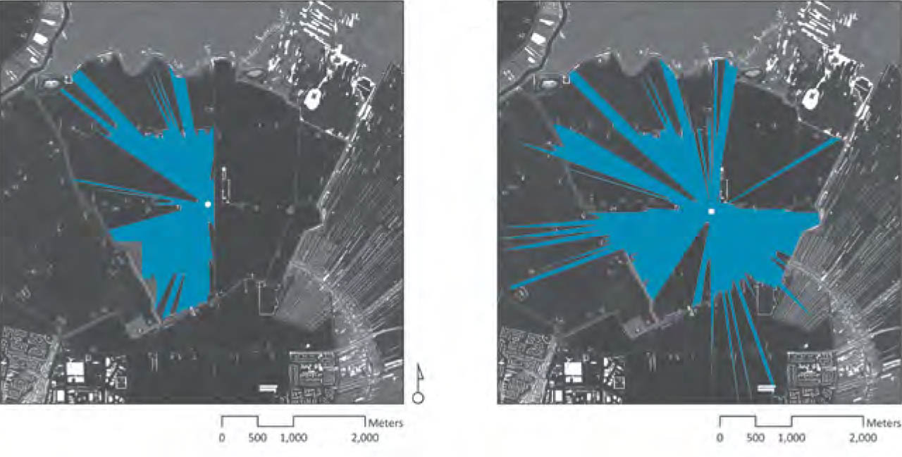
The article proposes a procedure that describes the visual landscape, which takes advantage of improvements in measurement techniques, developments in GIS and availability of high-resolution topographic data. The procedure is developed for policy making and spatial planning purposes, and provides information about one specific aspect of the visual landscape, landscape openness. In the remainder of the article, first the concept of landscape openness is explained, then a method to model landscape openness is proposed. Subsequently, a procedure to use this model for policy making purposes is demonstrated. Finally the results of an evaluation of the procedure with policy makers are discussed.
How to Cite
Published
Issue
Section
License
Copyright (c) 2011 Gerd Weitkamp

This work is licensed under a Creative Commons Attribution 4.0 International License.
References
Antrop, M. (2004) Landscape change and the urbanization process in Europe. Landscape and Urban Planning 67(1-4); 9-26
Antrop, M. (2005) Why landscapes of the past are important for the future. Landscape and Urban Planning 70(1-2); 21-34
Appleton, J. (1975) The Experience of Landscape. London, John Wiley.
Aspinall, R. J. (2005) GIS and landscape conservation. In: Longley, P. A. et al. (eds.), Geographical information systems: principles, techniques, applications and management. New York, Wiley, pp 358
Atchison, D. A., and Smith, G. (2001) Optics of the Human Eye. Oxford, Elsevier Health Sciences.
Baldwin, J., Fisher, P. et al. (1996) Modelling Environmental Cognition of the View With GIS. Third International Conference/Workshop on Integrating GIS and Environmental Modeling, Santa Fe, New Mexico.
Ball, K., Owsley, C. et al. (1993) Visual attention problems as a predictor of vehicle crashes in older drivers. Investigative Ophthalmology and Visual Science 34(11); 3110-3123
Batty, M. (2001) Exploring isovist fields: space and shape in architectural and urban morphology. Environment and Planning B: Planning and Design 28; 123-150
Bell, S. (1999) Landscape: Pattern, Perception and Process. London, E & FN Spon.
Benedikt, M. L. (1979) To take hold of space: isovists and isovists fields. Environment and Planning B: Planning and Design 6; 47-65
Bishop, I. D., and Hulse, D. W. (1994) Prediction of scenic beauty using mapped data and geographic information systems. Landscape and Urban Planning 30; 59-70
Bourassa, S. (1990) A paradigm for landscape aesthetics. Environment and Behavior 22(6); 787-812
Brabyn, L. (2008) Using GIS to describe the landscape experience of hiking tracks. New Zealand Geographical Society 24th Conference. Victoria University of Wellington.
Buijs, A. E., Jacobs, M. H., et al. (1999) Graadmeters beleving: theoretische uitwerking en validatie van het begrip 'afwisseling'. Wageningen, Staring Centrum.
Caduff, D., and Timpf, S. (2008) On the assessment of landmark salience for human navigation. Cognitive Processing 9(4); 249-267
Cash, D. W., and Buizer, J. (2005) Knowledge-Action Systems for Seasonal to Interannual Climate Forecasting. Washington D. C.
Cash, D. W., Clark, W. C. et al. (2003) Knowledge systems for sustainable development. Proceedings of the National Academy of Sciences of the United States of America 100(14); 8086-8091
Coeterier, J. F. (1994) Cues for the perception of the size of space in landscape. Journal of Enviromental Management 42; 333-347
Coeterier, J. F. (1996) Dominant attributes in the perception and evaluation of the Dutch landscape. Landscape and Urban Planning 34(1); 27-44
Council of Europe (2000) European Landscape Convention. Florence.
Culagovski, R. (2007) Three dimensional isovist analysis method. SIGRADI, Mexico.
De Veer, A. A., and Burrough, P. A. (1978) Physiognomic landscape mapping in The Netherlands. Landscape Planning 5; 45-62
Doody, D. G., Kearney, P. et al. (2009) Evaluation of the Q-method as a method of public participation in the selection of sustainable development indicators. Ecological Indicators 9(6); 1129-1137
Dramstad, W. E., Tveit, M. S., et al. (2006) Relationships between visual landscape preferences and map-based indicators of landscape structure. Landscape and Urban Planning 78(4); 465-474
Fisher, P. F. (1991) First experiments in viewshed uncertainty: the accuracy of the viewshed area. Photogrammetric Engineering & Remote Sensing 57(10); 1321-1327
Fisher, P. F. (1996) Extending the applicability of viewsheds in landscape planning. Programmetric Engeneering and Remote Sensing 62(11); 1297-1302
Franz, G., and Wiener, J. M. (2005) Exploring isovist-based correlates of spatial behavior and experience. The 5th Space Syntax Symposium, Delft, The Netherlands.
Geertman, S. (2002) Participatory planning and GIS: A PSS to bridge the gap. Environment and Planning B: Planning and Design 29(1); 21-35
Gifford, R. (1987) Environmental psychology: principles and practice. Boston, Allyn and Bacon.
Hagerhall, C. M. (2001) Consensus in landscape preference judgements. Journal of Environmental Psychology 21(1); 83-92
Herzog, T. R. (1987) A cognitive analysis of preference for natural environments: mountains, canyons, and deserts. Landscape Journal 6(2); 140
Herzog, T. R., and Kropscott, L. S. (2004) Legibility, mystery, and visual access as predictors of preference and perceived danger in forest settings without pathways. Environment and Behavior 36(5); 659
Jacobs, K., Garfin, G. et al. (2005) More than Just Talk: Connecting Science and Decision Making. Environment 47(9); 17
Kaplan, R., Kaplan, S. et al. (1989) Environmental preference: a comparison of four domains of predictors. Environment and Behavior 21(5); 509-530
Keller, A. C. (2009) Credibility and Relevance in Environmental Policy: Measuring Strategies and Performance among Science Assessment Organizations. Journal of Public Administration Research and Theory Advance Access.
Koomen, A. J. M., Maas, G. J. et al. (2007) Veranderingen in lijnvormige cultuurhistorische landschapselementen: resultaten van een steekproef over de periode 1900-2003. Wageningen, Wettelijke Onderzoekstaken Natuur & Milieu.
Llobera, M. (2003) Extending GIS-based visual analysis: the concept of visualscapes. International Journal of Geographical Information Science 17(1); 25-48
McNie, E. C. (2007) Reconciling the supply of scientific information with user demands: an analysis of the problem and review of the literature. Environmental Science and Policy 10(1); 17-38
Mucher, C. A., Klijn, J. A., et al. (2010) A new European Landscape Classification (LANMAP): A transparent, flexible and user-oriented methodology to distinguish landscapes. Ecological Indicators 10(1); 87-103
Nohl, W. (2001) Sustainable landscape use and aesthetic perception - preliminary reflections on future landscape aesthetics. Landscape and Urban Planning 54; 223-237
O'Looney, J. (2000) Beyond maps: GIS and decision making in local government. Redlands, ESRI Press.
O’Shea, C. (2006) Use of Geographic Information Systems (GIS) in Policy Making for Strategic Planning and Sustainable Development in Scotland.
OECD (1999) Environmental Indicators for Agriculture: Concepts and Framework. Paris, France, Organisation for Economic Co-operation and Development.
Palmer, J. F., and Hoffman, R. E. (2001) Rating reliability and representation validity in scenic landscape assessments. Landscape and Urban Planning 54(1-4); 149-161
Park, J. R., Stabler, M. J. et al. (2004) The use of a multiple criteria decision analysis to evaluate the effectiveness of landscape and habitat enhancement mechanisms: an example from the South Downs. Journal of Environmental Planning and Management 47(5); 773 - 793
Piorr, H.P. (2003) Environmental policy, agri-environmental indicators and landscape indicators. Agriculture, Ecosystems & Environment 98(1-3); 17-33
Rana, S. (2002). Isovist Analyst Extension. London, Centre for Advanced Spatial Analysis, University College London.
Roche, S., and Caron, C. (2009) The organisational facets of GIS. London, ISTE.
Rogge, E., Nevens, F. et al. (2007) Perception of rural landscapes in Flanders: Looking beyond aesthetics. Landscape and Urban Planning 82(4); 159-174
Scott, A. (2003) Assessing public perception of landscape: from practice to policy. Journal of Environmental Policy and Planning 5(2); 123
Singh, R. K., Murty, H. R. et al. (2009) An overview of sustainability assessment methodologies. Ecological Indicators 9(2); 189-212
Smardon, R. C., Palmer, J. F. et al. (1986) Foundations for Visual Project Analysis. New York, John Wiley & Sons.
Stamps, A. E. (2005) Isovists, enclosure, and permeability theory. Environment and Planning B: Planning and Design 32(5); 735 – 762
Steinitz, C. (1990) Toward a sustainable landscape with high visual preference and high ecological integrity: the Loop Road in Acadia National Park, USA. Landscape & Urban Planning 19(3); 213-250
Strumse, E. (1994) Perceptual dimensions in the visual preferences for agrarian landscapes in western Norway. Journal of Environmental Psychology 14(4); 281-292
Tandy, C. R. (1967) The isovist method of landscape survey. In: Murray, C.R. (ed.), Methods of Landscape Analysis. London, Landscape Research Group, pp 9-10
Tress, B., Tress, G. et al. (2001) Bridging human and natural sciences in landscape research. Landscape and Urban Planning 57(3-4); 137-141
Turner, A., Doxa, M. et al. (2001) From Isovists to visibility graphs: a methodology for the analysis of architectural space. Environment and Planning B: Planning and Design 28; 103-121
Tveit, M., Ode, et al. (2006) Key concepts in a framework for analysing visual landscape character. Landscape Research 31; 229-255
Tveit, M. S. (2009) Indicators of visual scale as predictors of landscape preference; a comparison between groups. Journal of Environmental Management 90(9); 2882-2888
US Forest Service (1974) The visual management system. National Forest Landscape Management. Washington, DC US Department of Agriculture.
Van der Ham, R. J. I. M., and Iding, J. A. M. E. (1971) Landscape Typology System based on Visual Elements: Methodology and Application. Wageningen.
Vouligny, É., Domon, G. et al. (2009) An assessment of ordinary landscapes by an expert and by its residents: Landscape values in areas of intensive agricultural use. Land Use Policy 26(4); 890-900
Wagner, M. (1985) The metric of visual space. Perception & psychophysics 38(6); 483-495
Wagner, M. (2006) The geometries of visual space. London, Lawrence Erlbaum Associates.
Wascher, D. M. (2000) The face of Europe. Policy perspectives for European landscapes: Policy perspectives for European landscapes. ECNC Technical Report Series. Tilburg, European Centre for Nature Conservation.
Weitkamp, G., Bregt, A. et al. (2007) Three Sampling Methods for Visibility Measures of Landscape Perception. COSIT 2007, Melbourne, Australia, Springer-Verlag.