A remote sensing information extraction method for intertidal zones based on Google Earth Engine
CHEN Huixin1(), CHEN Chao1(), ZHANG Zili2, WANG Liyan1, LIANG Jintao1
1. Marine Science and Technology College, Zhejiang Ocean University, Zhoushan 316022, China 2. Zhejiang Province Ecological Environment Monitoring Centre (Zhejiang Key Laboratory of Ecological and Environmental Monitoring,Forewarning and Quality Control), Hangzhou 310012, China
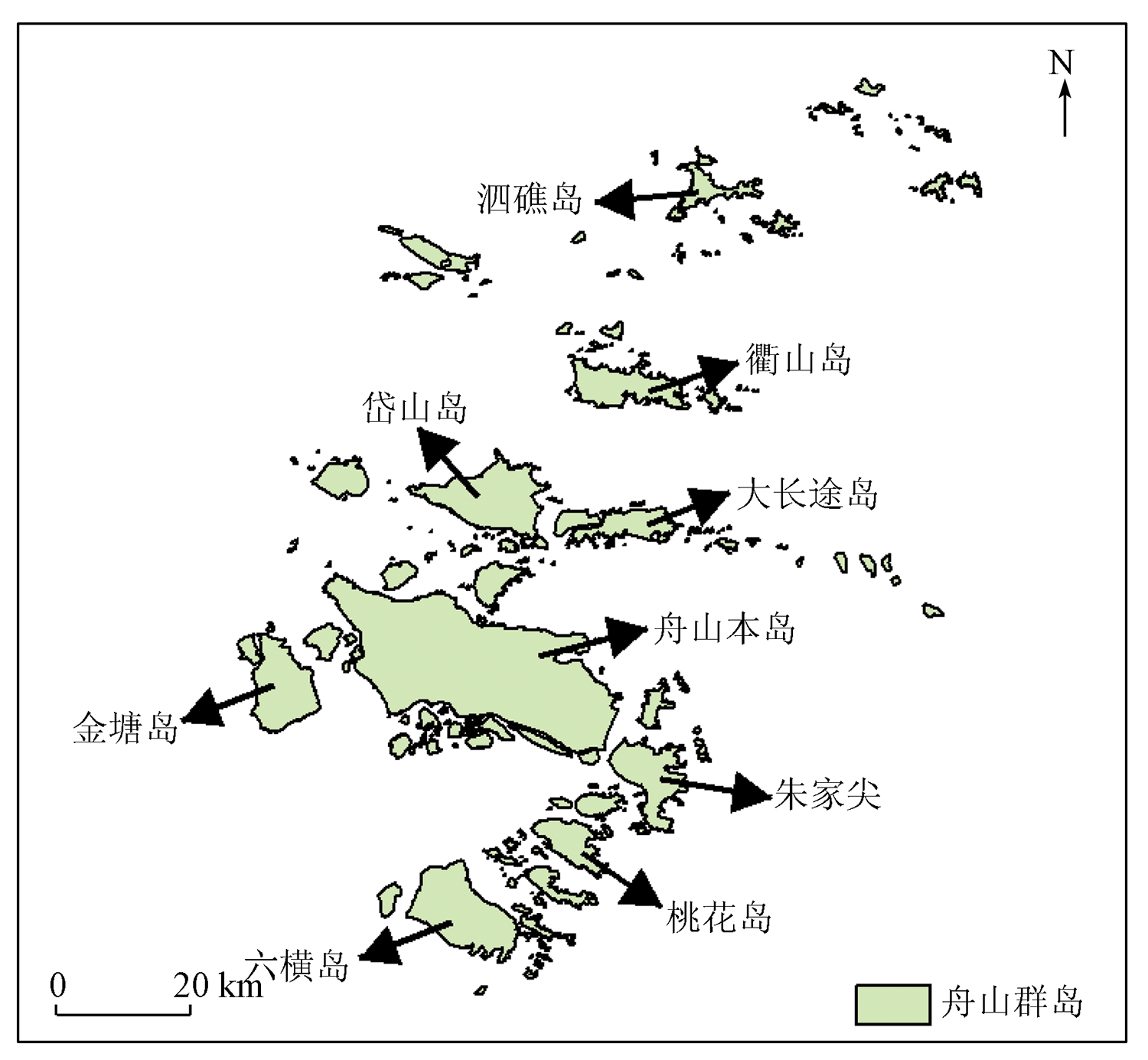
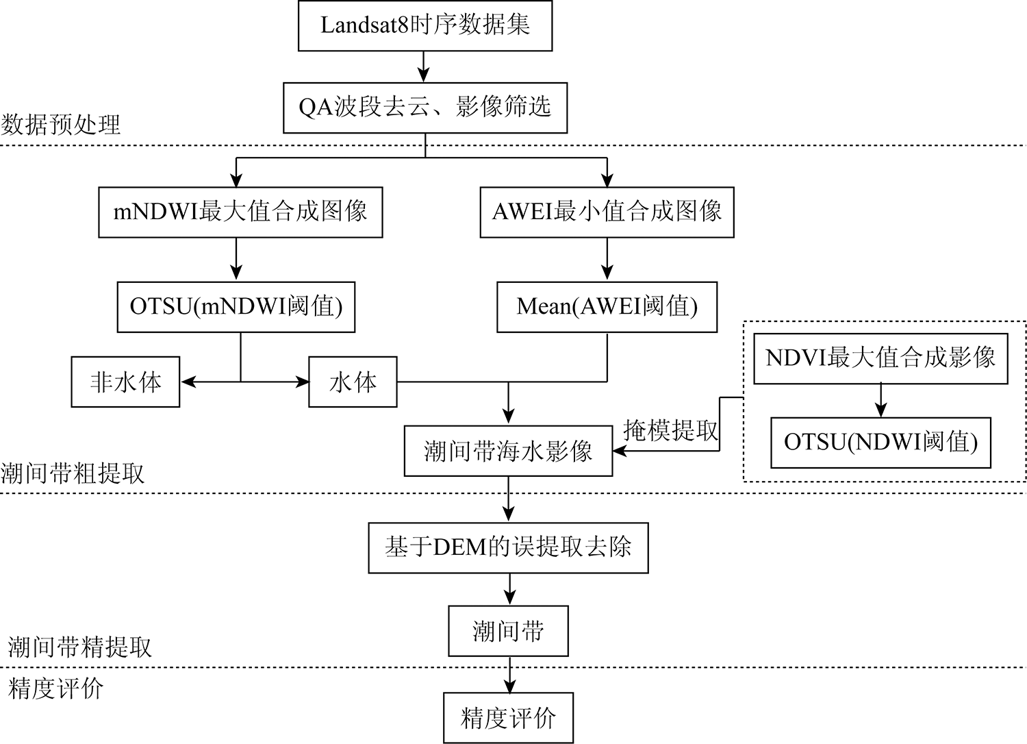
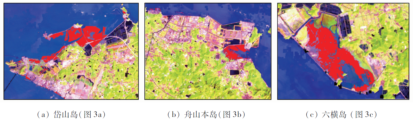
Intertidal zones, as important parts of coastal wetlands play a significant role in ecological and economic development. However, the dynamic interaction between seawater and land makes it difficult to accurately determine the tidal flat area using the remote sensing information extraction method based on instant remote sensing images. To solve this problem, this study developed an intertidal information extraction method based on Google Earth Engine (GEE) platform and remote sensing index. This proposed method was applied to study the coastal zone of Zhoushan Islands. First, a decision tree algorithm based on the fusion of the digital elevation model (DEM) data was built using the Landsat8 time series image data in 2021. Then, a multi-layer automatic decision tree classification model was formed using the maximum spectral index composite (MSIC) and the Otsu algorithm (OTSU). Based on this, the DEM data were fused to extract and calculate the area of the intertidal zone in Zhoushan Islands. The results show that the area of the intertidal zone in Zhoushan Islands is 35.19 km2 in 2021. The evaluation based on the Google Earth high-resolution images shows that this proposed method has a general precision of 97.7% and a Kappa coefficient of 0.95, indicating good extraction precision and practical effects. This method can provide data support for sustainable management and utilization of coastal zone resources through automatic and rapid extraction of intertidal information, thus promoting regional high-quality development.
陈慧欣, 陈超, 张自力, 汪李彦, 梁锦涛. 一种基于Google Earth Engine云平台的潮间带遥感信息提取方法[J]. 自然资源遥感, 2022, 34(4): 60-67.
CHEN Huixin, CHEN Chao, ZHANG Zili, WANG Liyan, LIANG Jintao. A remote sensing information extraction method for intertidal zones based on Google Earth Engine. Remote Sensing for Natural Resources, 2022, 34(4): 60-67.
Wang X L, Zhang J, Chu J L. Extraction of remotely sensed information of island intertidal zone and wetland:Taking the Dongsha Island as an example[J]. Advances Marine Science, 2005(4):477-481.
Liu R Q, Li J L, Sun C, et al. Classification of Yancheng coastal wetland vegetation based on vegetation phenological characteristics derived from Sentinel-2 time-series[J]. Acta Geographica Sinica, 2021, 76(7):1680-1692.
doi: 10.11821/dlxb202107008
Li J, Lei Y R, Cui L J, et al. Current status and research progress of coastal tidal flat wetlands in China[J]. Forest Resources Management, 2018(2):24-28,137.
Wu W, Li C X, Chen X C. Evaluation of the effectiveness of a coastal ecological restoration project based on ecosystem services: A case study on Yingwuzhou Wetland,China[J]. Journal of East China Normal University (Natural Science), 2020(3): 98-108.
Wang Y L, Wang Y D, Zheng H M. Monitoring dynamic changes of coastal wetlands and its surrounding areas in Quanzhou Bay based on multi-temporal remote sensing images[J]. Journal of Gannan Normal University, 2017, 38(3):102-107.
[6]
Ren C, Wang Z, Zhang Y, et al. Rapid expansion of coastal aquaculture ponds in China from Landsat observations during 1984—2016[J]. International Journal of Applied Earth Observation and Geoinformation, 2019, 82: 101902.
doi: 10.1016/j.jag.2019.101902
[7]
Meng W, Hu B, He M, et al. Temporal-spatial variations and driving factors analysis of coastal reclamation in China[J]. Estuarine,Coastal and Shelf Science, 2017, 191: 39-49.
doi: 10.1016/j.ecss.2017.04.008
Cheng L N, Zhong C R, Li X Y, et al. Rapid and automatic classification of intertidal wetlands based on intensive time series Sentinel-2 images and Google Earth Engine[J]. National Remote Sensing Bulletin, 2022, 26(2):348-357.
Luo Y M. Sustainability associated coastal eco-environmental problems and coastal science development in China[J]. Bulletin of Chinese Academy of Sciences, 2016, 31(10): 1133-1142.
[10]
Gorelick N, Hancher M, Dixon M, et al. Google Earth Engine: Planetary-scale geospatial analysis for everyone[J]. Remote Sensing of Environment, 2017, 202:18-27.
doi: 10.1016/j.rse.2017.06.031
[11]
Kumar L, Mutanga O. Google Earth Engine applications since inception: Usage,trends,and potential[J]. Remote Sensing, 2018, 10(10):1509.
doi: 10.3390/rs10101509
Fu D J, Xiao H, Su F Z, et al. Remote sensing cloud computing platform development and Earth science application[J]. National Remote Sensing Bulletin, 2021, 25(1):220-230.
Zou Y D, He L, Zhang X P, et al. Characteristics of land use structure change in Beiluo River basin during 1970—2019 based on Google Earth Engine[J]. Bulletin of Soil and Water Conservation, 2021, 41(6):209-219.
Dai S P, Yi X P, Luo H X, et al. Mapping land use in Hainan Island based on Google Earth Engine and Landsat time series data[J]. Journal of Tropical Crops, 2021, 42(11):3351-3357.
Chen K M, Zhu X D. Remote Sensing of spatio-temporal dynamics of saltmarsh vegetation along South China Coast based on Google Earth Engine[J]. Remote Sensing Technology and Application, 2021, 36(4):751-759.
Li R N, Ou G L, Dai Q L, et al. Forest types classification of Shangri-La based on Google Earth Engine and Landsat time-series data[J]. Journal of Southwest Forest University, 2020, 40(5):115-125.
[17]
Hansen M C, Potapov P V, Moore R, et al. High-resolution global maps of 21st-century forest cover change[J]. Science, 2013, 342(6160):850-853.
doi: 10.1126/science.1244693
pmid: 24233722
[18]
Pekel J F, Cottam A, Gorelick N, et al. High-resolution mapping of global surface water and its long-term changes[J]. Nature, 2016, 540(7633):418-422.
doi: 10.1038/nature20584
Run Y D, Cui Y P, Qin Y C, et al. Spatial-temporal dynamic of water and land in the Yellow River beach area based on Google Earth Engine[J]. Yellow River, 2021, 43(9):85-89,93.
[20]
Chen B Q, Xiao X M, Li X P, et al. A mangrove forest map of china in 2015: Analysis of time series Landsat7/8 and Sentinel-1A imagery in Google Earth Engine cloud computing platform[J]. ISPRS Journal of Photogrammetry and Remote Sensing, 2017, 131:104-120.
doi: 10.1016/j.isprsjprs.2017.07.011
[21]
Wang X X, Xiao X M, Zou Z H, et al. Tracking annual changes of coastal tidal flats in china during 1986—2016 through analyses of Landsat images with Google Earth Engine[J]. Remote Sensing of Environment, 2018, 238:110987-111002.
doi: 10.1016/j.rse.2018.11.030
[22]
Campbell A D, Wang Y Q. Salt marsh monitoring along the Midatlantic Coast by Google Earth Engine enabled time series[J]. PLOS One, 2020, 15(2):229605-229628.
[23]
Catalao J, Nico G. Multitemporal backscattering logistic analysis for intertidal bathymetry[J]. IEEE Transactions on Geoscience and Remote Sensing, 2017, 55(2):1066-1073.
doi: 10.1109/TGRS.2016.2619067
[24]
Zhang X, Treitz P M, Chen D, et al. Mapping mangrove forests using multi-tidal remotely-sensed data and a decision-tree-based procedure[J]. International Journal of Applied Earth Observation and Geoinformation, 2017, 62: 201-214.
doi: 10.1016/j.jag.2017.06.010
[25]
Dhanjal-Adams K L, Hanson J O, Murray N J, et al. The distribution and protection of intertidal habitats in Australia[J]. Emu-Austral Ornithology, 2016, 116(2): 208-214.
doi: 10.1071/MU15046
[26]
Zhang K Y, Dong X Y, Liu Z G, et al. Mapping tidal flats with Landsat8 images and Google Earth Engine:A case study of the China’s Eastern Coastal Zone circa 2015[J]. Remote Sensing, 2019, 11(8): 924.
doi: 10.3390/rs11080924
[27]
Wang X X, Xiao X M, Zou Z H, et al. Mapping coastal wetlands of China using time series Landsat images in 2018 and Google Earth Engine[J]. ISPRS Journal of Photogrammetry and Remote Sensing, 2020, 163: 312-326.
doi: 10.1016/j.isprsjprs.2020.03.014
[28]
Murray N J, Phinn S R, Clemens R S, et al. Continental scale mapping of tidal flats across East Asia using the Landsat archive[J]. Remote Sensing, 2012, 4(11):3417-3426.
doi: 10.3390/rs4113417
[29]
Murray N J, Phinn S R, DeWitt M, et al. The global distribution and trajectory of tidal flats[J]. Nature, 2019, 565(7738): 222-225.
doi: 10.1038/s41586-018-0805-8
[30]
Jia M, Wang Z, Mao D, et al. Rapid,robust,and automated mapping of tidal flats in China using time series Sentinel-2 images and Google Earth Engine[J]. Remote Sensing of Environment, 2021, 255: 112285.
doi: 10.1016/j.rse.2021.112285
[31]
Sagar S, Roberts D, Bala B, et al. Extracting the intertidal extent and topography of the Australian coastline from a 28 year time series of Landsat observations[J]. Remote Sensing of Environment, 2017, 195: 153-169.
doi: 10.1016/j.rse.2017.04.009
[32]
Liu Y, Li M, Cheng L, et al. Topographic mapping of offshore sandbank tidal flats using the waterline detection method: A case study on the Dongsha Sandbank of Jiangsu Radial Tidal Sand Ridges,China[J]. Marine Geodesy, 2012, 35(4): 362-378.
doi: 10.1080/01490419.2012.699501
[33]
Wang X, Gao X, Zhang Y, et al. Land-cover classification of coastal wetlands using the RF algorithm for Worldview-2 and Landsat8 images[J]. Remote Sensing, 2019, 11(16): 1927.
doi: 10.3390/rs11161927
[34]
Zhang H, Jiang Q, Xu J. Coastline extraction using support vector machine from remote sensing image[J]. Journal of Multimedia, 2013, 8(2): 175-182.
Chen C, Chen H X, Chen D, et al. Coastline extraction and spatial-temporal variations using remote sensing technology in Zhoushan Islands[J]. Remote Sensing for Land and Resources, 2021, 33(2):141-152.doi: 10.6046/gtzyyg.2020248.
doi: 10.6046/gtzyyg.2020248
[36]
Chen H, Chen C, Zhang Z, et al. Changes of the spatial and temporal characteristics of land-use landscape patterns using multi-temporal Landsat satellite data: A case study of Zhoushan Island,China[J]. Ocean and Coastal Management, 2021, 213: 105842.
doi: 10.1016/j.ocecoaman.2021.105842
[37]
Chen C, Chen H, Liao W, et al. Dynamic monitoring and analysis of land-use and land-cover change using Landsat multitemporal data in the Zhoushan Archipelago,China[J]. IEEE Access, 2020, 8: 210360-210369.
doi: 10.1109/ACCESS.2020.3036128
Zhang H, Li H Y, Li H J, et al. Accuracy evaluation of remote sensing elevation data in alpine mountains based on airborne LiDAR[J]. Remote Sensing Technology and Application, 2021, 36(6):1311-1320.
Rao P, Wang J L. Water extraction based on the optimal subregion and the optimal indexes combined[J]. Journal of Geo-Information Science, 2017, 19(5):702-712.
[41]
McFeeters S K. The use of the normalized difference water index (NDWI) in the delineation of open water features[J]. International Journal of Remote Sensing, 1996, 17(7):1425-1432.
doi: 10.1080/01431169608948714
[42]
Rogers A S, Kearney M S. Reducing signature variability in unmixing coastal marsh thematic mapper scenes using spectral indices[J]. International Journal of Remote Sensing, 2004, 25(12):2317-2335.
doi: 10.1080/01431160310001618103
[43]
Xu H Q. Modification of normalized difference water index (NDWI) to enhance open water features in remotely sensed imagery[J]. International Journal of Remote Sensing, 2006, 27(14): 3025-3033.
doi: 10.1080/01431160600589179
[44]
Feyisa G L, Meilby H, Fensholt R, et al. Automated water extraction index: A new technique for surface water mapping using Landsat imagery[J]. Remote Sensing of Environment, 2014, 140:23-35.
doi: 10.1016/j.rse.2013.08.029
[45]
Ji L, Zhang L, Wylie B. Analysis of dynamic thresholds for the normalized difference water index[J]. Photogrammetric Engineering and Remote Sensing, 2009, 75(11):1307-1317.
doi: 10.14358/PERS.75.11.1307
[46]
Tucker C J. Red and photographic infrared linear combinations for monitoring vegetation[J]. Remote Sensing of Environment, 1979, 8(2): 127-150.
doi: 10.1016/0034-4257(79)90013-0
Wu B, Qin Z Y. New approaches for the automatic selection of the optimal threshold in image binarization[J]. Journal of Institute of Surveying and Mapping, 2001(4):283-286.
Wang Z H, Xin C L, Sun Z, et al. Automatic extraction method of aquatic vegetation types in small shallow lakes research based on Sentinel-2 data: A case study of Cuiping Lake[J]. Remote Sensing Information, 2019, 34(5):132-141.
[49]
高媛. 全球30米土地覆盖产品的精度评估研究[D]. 西安: 西安科技大学, 2021.
Gao Y. Study on accuracy assessment of global 30 m land cover products[D]. Xi’an: Xi’an University of Science and Technology, 2021.
 2022, Vol. 34
  ), 陈超1(