Mainstreaming Disaster Risk Reduction into Local Development Plans for Rural Tropical Africa: A Systematic Assessment


Interuniversity Department of Regional and Urban Studies and Planning (DIST)-Politecnico and University of Turin, viale Mattioli 39, 10125 Turin, Italy
*
Author to whom correspondence should be addressed.
Sustainability 2020, 12(6), 2196; https://doi.org/10.3390/su12062196
Submission received: 21 January 2020
/
Revised: 28 February 2020
/
Accepted: 9 March 2020
/
Published: 12 March 2020
(This article belongs to the Special Issue Risk-Informed Sustainable Development in the Rural Tropics)
Abstract
:Disaster risk reduction in rural Africa can contribute to reducing poverty and food insecurity if included in local development plans (LDPs). Five years after the Sendai Framework for Disaster Risk Reduction (DRR), we do not know how much risk reduction is practiced in rural Africa. The aim of this assessment is to ascertain the state of mainstreaming DRR in development planning in the rural jurisdictions of tropical Africa. One hundred and ninety-four plans of 21 countries are considered. Ten characteristics of the plans are examined: Climate trends, hydro-climatic hazards, vulnerability and risk assessments, alignment with Sendai Framework, vision, strategies and objectives, DRR actions, internal consistency, DRR relevance and funding sources, local and technical knowledge integration, public participation. It is found that local climatic characterization is almost always absent and risk reduction is an objective of the plans in one case out of three. Prevention actions prevail over those of preparedness. There is poor participation in the plan preparation process and this limits the implementation of the actions. A modification of the national guidelines on the preparation of LDPs, the orientation of official development assistance towards supporting climate services and the training of local planners, together with the increase of financial resources in local jurisdictions are essential for improving DRR at local scale.
1. Introduction
Tropical Africa presents specific characteristics as opposed to other regions of the Global South. Firstly, 62.5% of the population is still rural [1]. Over half of jobs and 69% of income come from agriculture [2]. Despite this, 58% of the population is in conditions of food insecurity [3]. Poverty and inequalities between countries and within individual countries reach the world’s highest levels [4]. In these conditions, the development of agriculture is considered better for absorbing the poor than industry and services [5,6,7,8,9]. However, agriculture is strongly exposed to climate change (CC), which affects rain-fed crops and livestock [10,11,12], casts smallholders into deeper poverty [13], and makes investments vulnerable [14] because of low adaptive capacity [15]. Finally, fluvial flooding and dust storms affecting urban areas [16,17,18], are formed in the surrounding rural areas and it is there that they should be treated primarily [19]. For all these reasons, rural environment remains the hot spot for disaster risk reduction (DRR) in Africa.
Smallholder farmers from tropical Africa have insufficient financial capital and willingness to change to significantly reduce disaster risk [20] and sometimes lack natural, social, and human capital [21]. DRR should first be addressed by the local governments of all those countries where the process of administrative decentralization has assigned them the task of conserving the environment and protecting the population from natural hazards. In addition, precisely for this reason Official Development Assistance (ODA) helps local governments strengthen their capacities with specific programs [15]. The substantial reduction of disaster loss and damage and the increase of local disaster risk reduction strategies by 2030 has become a target of the Sendai Framework for Disaster Risk Reduction (2015) [22,23]. Five years after the Sendai Framework we only know the number of African countries with DRR strategies in place: Just seven, according to UNDRR, which is in charge of monitoring the implementation of the Sendai Framework [24]. We do not know if this results from a lack of information or from national strategies which “often do[es] not penetrate to the local level” [25].
However, the number of strategies in place does not guarantee a reduction of risk at local scale. Peer-reviewed literature points out that DRR mainstreaming into local development plans (LDPs) is often based upon rough climatic analyses, produced with little public participation, done with few actions, mostly of little significance, and lacks sufficient resources for implementation [26,27,28,29,30,31,32,33,34,35,36,37,38,39]. Genuine public participation in the planning process is critical to reducing disaster risk. This is particularly true in rural areas, where almost all actions require the direct involvement of smallholder farmers and herders [40,41,42,43,44,45].
The problem is, therefore, to know the content of the DRR strategies in place locally and the process by which they were prepared, rather than just knowing their number. An evaluation of the local DRR strategies can therefore highlight the aspects to be improved in the DRR and inspire the ODA consequently.
The aim of this article is to ascertain the mainstreaming of DRR in local development plans for rural areas in tropical Africa.
We will proceed by identifying the local jurisdictions. To compare the LDPs, it is necessary to investigate a homogeneous climatic area. The tropical zone is the most present in Africa. Within it, the analysis is restricted to English-speaking, French-speaking, and Portuguese-speaking jurisdictions with plans in force: Municipalities, cantons, districts, counties, sometimes regions. The LDPs are identified by Google search. The plans considered are only those in force at September 2019 in jurisdictions with at least 90% of the territory in the tropical zone and rural population exceeding 50%. With these restrictions, we obtained 194 plans, covering 24% of rural jurisdictions in 21 tropical African countries.
Ten characteristics of the plans are considered: (i) Climatic trend, (ii) hazard identification, (iii) existence of vulnerability and risk assessments, (iv) alignment with the Sendai framework for DRR, (v) vision, strategies and objectives, (vi) DRR actions, (vii) internal coherence, (viii) budget size and origin, (ix) local and scientific knowledge integration, (x) public participation in the plan preparation.
Although DRR mainstreaming in the LDPs is in place in half of the countries of tropical Africa, improvements are needed in analysis and planning, as well as resources to achieve the actions, if DRR is to be consolidated at local scale.
The importance of this article is in highlighting the weaknesses of today’s local DRR. However, also in proposing a simple assessment framework, repeatable over time and on a larger scale, which was still missing. These features can facilitate the transition from occasional assessments to tracking the DRR in local development plans.
2. Materials and Methods
The assessment is split into four phases. The first phase identifies the jurisdictions being studied. We begin by outlining the tropical zone according to the Köppen-Geiger classification (tropical rain forest, tropical monsoon, tropical wet and dry or savanna, hot and hot-semi-arid desert climates) based upon temperatures and precipitation, as calculated in the period 1980–2016 on a one kilometer grid [46], which updates, in greater spatial resolution and over a more recent timeframe, the work of Rubel and Kottek [47]. We then identify the government level responsible for producing local development plans. In some countries, it is the municipality, in others it is the district, the canton, the county, and sometimes the region. In Africa, these different jurisdictions do not necessarily correspond to territories of growing extension: A municipality in Cameroon, for example, may be larger and more populated than a district in Uganda. The jurisdictions of Angola, Ethiopia, Kenya, Madagascar, Malawi, Namibia, South Africa, Tanzania, Uganda, Zambia and Zimbabwe, which fall only in a small part in the tropical zone, were excluded. Finally, we considered only the jurisdictions with rural population exceeding 50% (Figure 1).
During the second phase, the plans are obtained. We searched Google with the name of each local jurisdiction and the integrated, local, municipal or strategic development plan and obtained 194 plans of 21 countries of which 107 were prepared after the Sendai framework for DRR, therefore likely to integrate its principles (Figure 2).
We also obtained the national strategies and guidelines for the preparation of the LDPs for each of the 21 countries.
The third phase identifies the information required to examine the 10 key characteristics of the plans: Climatic trend, hydro-climatic hazards, vulnerability and risk assessment, Sendai alignment, vision, strategy and objectives, actions, internal consistency, DRR budget and source, local and scientific knowledge integration, public participation (Table S1).
During the fourth phase, the information is collected, processed, and analyzed. The analysis of the climatic characterization ascertains if the plans are based on a series of at least thirty years of climatic observations and trace long-term local climatic scenarios. It is ascertained whether the plan is based on a CC vulnerability or risk assessment of the local communities. The alignment of the LDPs with the Sendai Framework verifies that the plan is subsequent to the National DRR Strategy and checks that at least the DRR and Sendai terms appear among the words of the plan. The analysis of the vision, strategy, and objectives verifies if DRR is present. The actions are broken down by purpose: Prevention, namely “to avoid existing and new disaster risks”, and preparedness, i.e. “to recover from the impacts of likely, imminent or current disasters” [48]. Therefore, the actions are compared with those recurring in the literature on the individual hazards [49,50,51,52,53,54,55,56,57,58,59,60] to verify their completeness. The internal consistency analysis ascertains whether the plan relates to the climate trend, impacts, and possible solutions using specific frameworks. Secondly, the actions proposed by the communities are considered to verify if they subsequently appear among those retained by the plan and prioritized for the first year. The analysis of the budget reserved to DRR actions follows. In this regard, it is important to ascertain the share of the budget reserved for the DRR and to what extent it comes from the local administration’s own resources, from the central government or from donors. The planning process is then examined to discover if local and technical knowledge has been integrated. Finally, the role of public participation in preparing 105 municipal development plans is ascertained: Analysis, planning, adopting, implementing, monitoring and evaluating (M&E) the plan while representing the many communities that make up a rural jurisdiction and gender constitute as many levels of participation [41].
3. Results
Monitoring the implementation of the Sendai Framework offers little information on the rural jurisdictions of tropical Africa. Considering DRR mainstreaming in 194 LDPs in force in half of the African countries gives a vision of 1.2 million km2 populated by 37 million inhabitants. The rural jurisdictions considered, irrespective of the level (municipality, district or canton, county, region) are vast. The municipality of Kagisano Molopo (South Africa) for example, spreads across 23,800 km2, that of Mintom (Cameroon) over 11,000 km2. Jurisdictions contain an average of 52 settlements, as well as the municipal capital town and an average population of 193,000 inhabitants. Vast territories present several micro-climates and hazards that differ from one area to another, to be addressed with specific actions. In addition, the presence of many communities makes the representation during the plan preparation process a challenge.
3.1. Local Planning Overview
The local jurisdictions use different plans depending on the country: Municipal (district or regional) development plan, municipal (or county) integrated development plan, municipal (district or regional) strategic plan. Irrespective of the name, the plans have some common characteristics. Firstly, they are medium-term tools (3–5 years) prepared following national guidelines. Secondly, the plans are split into two parts: A factual base (with climate section) identifies the problems and available resources, then the actual planning, which usually defines the vision, strategies, objectives and actions. The latter are localized, quantified, their cost is defined, as well as the origin of the funds to be used to finance them. Some LDPs take stock of the previous plan. Other plans present the actions necessary for each community and the priority actions to be implemented during the first year. The strategies never detail the actions (quantity, costs). In the five countries with the highest number of plans, those in force and freely accessible on the web cover from 12% of the rural districts of Uganda to 94% of rural municipalities of South Africa (Table 1, Figure 3).
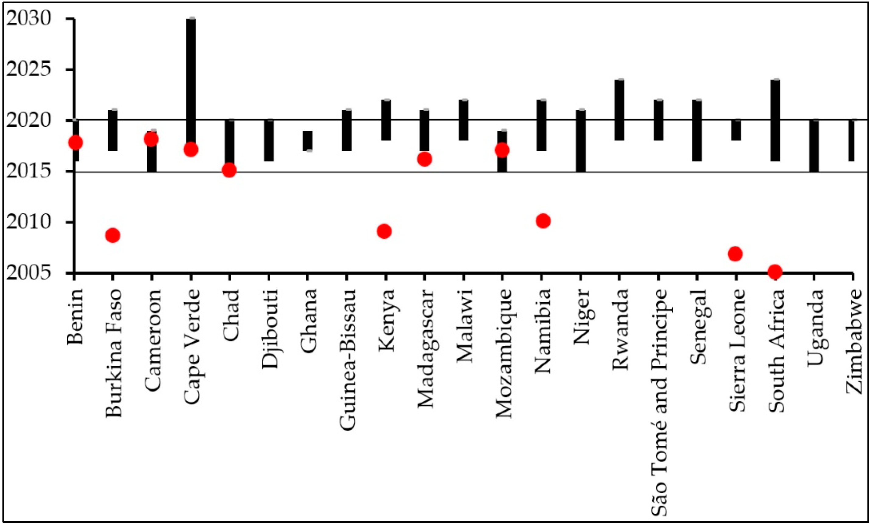
The Sendai Framework schedules the alignment of local DRR strategies with national ones. In fact, some countries have a national strategy (Cape Verde, Madagascar), others have a national plan or a preparation, management or response policy to the risk (Burkina Faso, Kenya, Mozambique, Namibia, South Africa, Uganda) or a national plan to strengthen DRR capacities (Chad, Niger). These heterogeneous tools at national scale define some important elements for local planning: The legal framework, the competencies of the different players, the operational procedures, the coordination between players in the case of emergency, the information path in the case of early warning, the capacities to be strengthened, the awareness-raising and participation, the methods of post-disaster recovery, and the funds to implement all of this. Today, out of the 21 investigated countries, 10 do not have a national strategy, three countries (Benin, Cameroon, and Mozambique) have LDPs already in force before the national strategy and only eight countries have a strategy following which a new generation of LDPs was formulated, thus being in line with the Sendai Framework (Figure 4). Without a national strategy, the local plans would be deprived of the aforementioned elements.
3.2. Analysis Phase
3.2.1. Climate Characterization and Hazards
LDPs rarely characterize the climate as they consider too short a timeframe, or they are based only on local knowledge. In Niger, the latest generation LDPs are the exception: Precipitation and temperatures analyzed over a thirty-year series of data, identification of dry spells, sometimes of wind. Increase of temperatures, heavy rainfall, late onset of the wet season, and decline in total annual rainfall are the changes most frequently observed (Table 2). The CC local scenarios are never presented unless the national ones are reported. Conversely, the LDPs almost always identify the main hydro-climatic threats. Drought is by far the hazard most frequently reported by the plans. This is followed, with less frequency, by strong winds, bush fires, and floods. High temperatures, heavy storms, sea level rise, lightening, hailstorm, dust storms, salt-water intrusion and cyclones are reported more rarely (Table 3).
3.2.2. Vulnerability and Risk Assessments
The considered LDPs do not have vulnerability assessments (quantification and localization of the vulnerable population to the individual hazards) and the very term “vulnerability” is found only in 43% of the plans. Even the risk assessment (probability of occurrence of the individual hazards, risk level, risk mapping) is absent. Moreover, the term hazard appears in only 46% of the plans.
3.3. Planning Phase
The LDPs mention the Sendai framework in 40% of cases and DRR in 46% of cases, although they include some typical DRR action without being defined as such. Many plans provide a long-term vision. The most frequent envisage a prosperous, wealthy community, which has achieved sustainable development and a high quality of life. The strategies proposed to achieve this vision involve the construction of roads, water, sanitation and hygiene (WASH), afforestation and use of green energy. The most frequent objectives remain the disaster prevention and response, the construction and maintenance of roads, increased access to drinking water, to basic services, to electricity (Table 4).
As to the actions, those of DRR prevention (119 plans) prevail over those of preparedness (49 plans). The most frequently illustrated actions of hydro-climatic DRR are afforestation (50%), the use of drought tolerant crops (23%), the construction or rehabilitation of boreholes and wells (22%) and CC sensitization (18%). The preparedness actions are much less frequent: Disaster relief (24%), early warning (24%), and disaster management plan (18%) (Table 5).
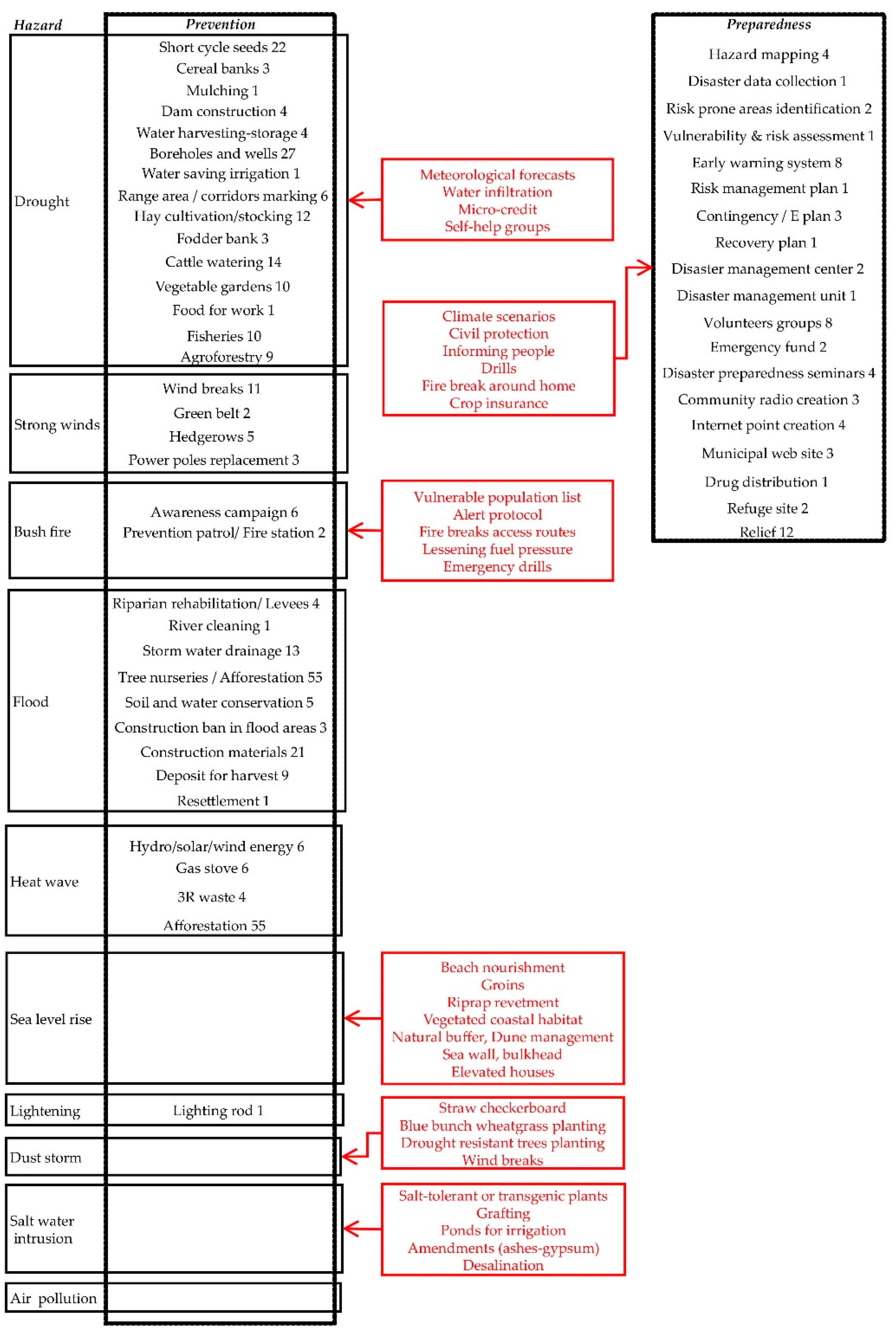
We note the absence of some canonical actions for addressing the individual hazards. With respect to drought, there is no weather forecasting actions to encourage run-off infiltration, crop residues stocking, micro-credit, and self-help community groups [52], no crop insurance [60]. In relation to strong winds, there is no house retrofitting. There are no actions to deal with bush fires with respect to the many already trialed elsewhere in prevention (vulnerable population localization, alert protocols, access routes, lessening fuel pressure in forest areas) and in preparedness (fire break around homes) [53,54]. Half of the countries considered overlook the Ocean. Sea level rise threatens long stretches of West African coast [61]. The plans do not envisage any measure to reduce the risk of coastal flooding, such as natural buffers, beach nourishment, sea walls, and elevated houses [51]. Apart from the reduction of emissions, which has a long-term effect on the local climate, and afforestation, there are no other actions aimed at reducing the impact of heat waves. There is no early warning, no heat wave action plan. The prevention of dust storms with the stabilization of dunes with straw checkerboard and the increase of arboreal and herbaceous vegetation on denuded soils, for example, using wheatgrass, are not planned [55,56,57]. There are no measures to address salt-water intrusion consequent to sea level rise [58,59]: A frequent phenomenon in coastal areas that affects agriculture and access to drinking water. As to preparedness in general, there are no climate scenarios. Civil protection is mentioned by just 21% of the plans. There is no mention of simulations and drills, and even less so, actions informing the public on what to do in case of a warning (Figure 5). Resilience is a frequent word of the plan (65%).
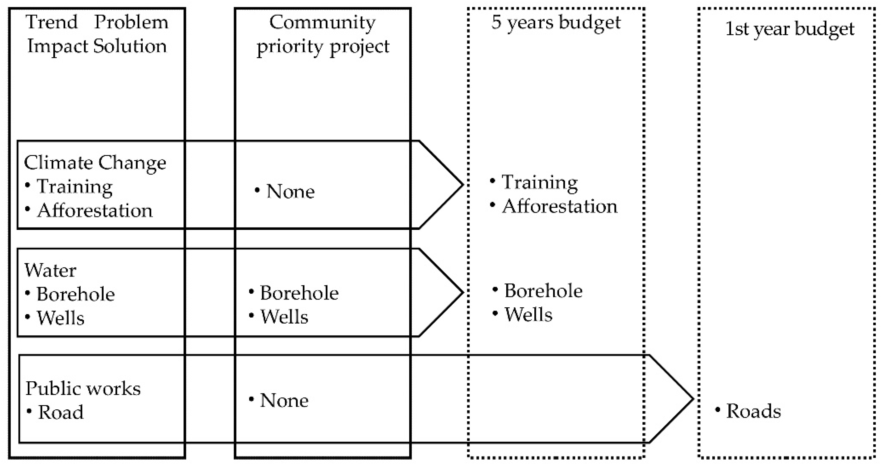
The LDPs use different instruments to control the coherence between problems identified, objectives, and actions. The most complete are proposed by Cameroon’s LDPs with the climatic threat-impact-strategies-actions framework and the logical framework (objective-outcome-indicator) (Table 6). Despite this, the DRR actions proposed by the individual communities rarely appear among the priority ones of the plan (Figure 6).
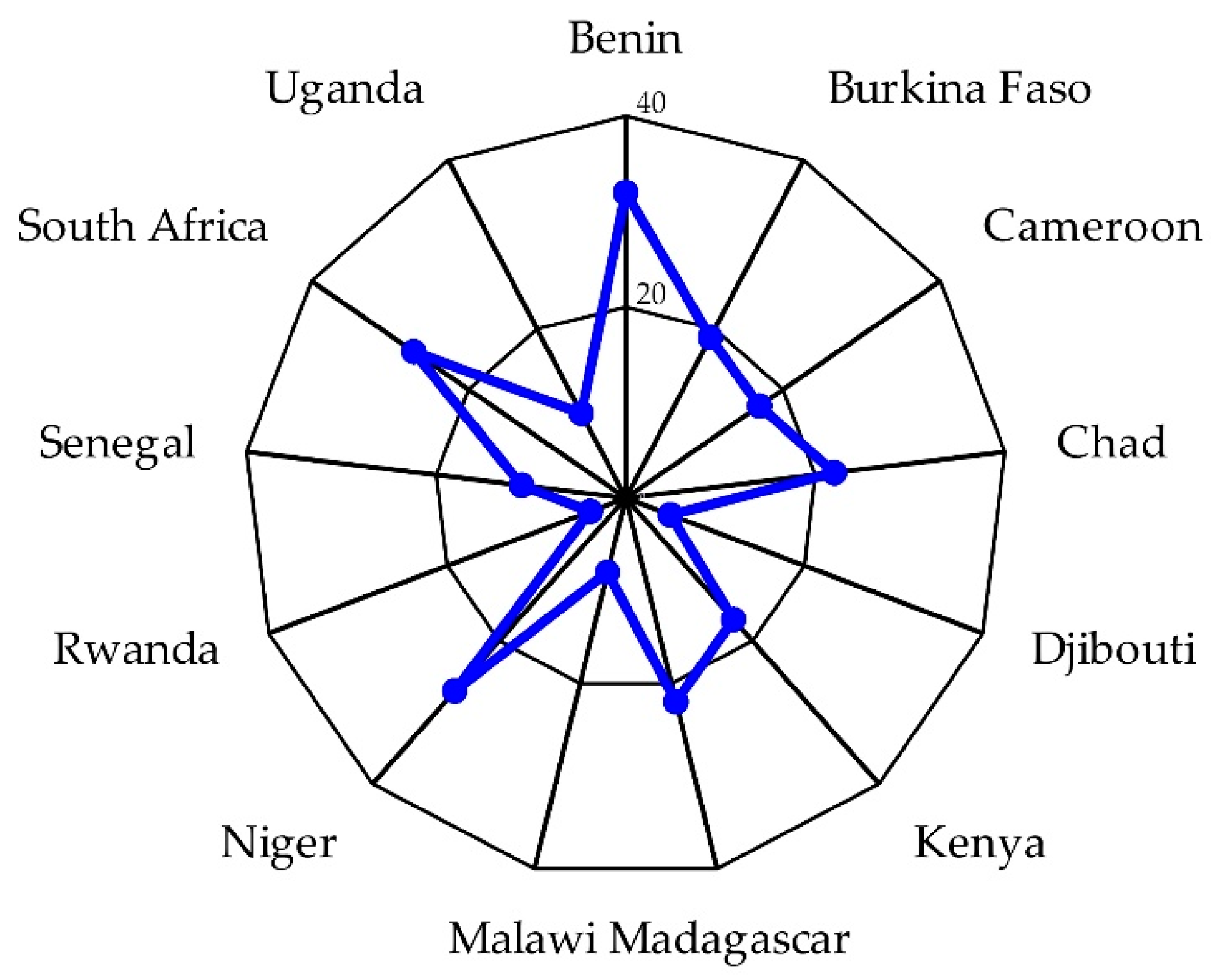
The resources scheduled by the plans in the medium-term to implement DRR vary greatly from country to country, but in the majority of cases they are below 20% of overall expenditure. Benin, Niger, and South Africa have plans that reserve the highest share for DRR. Rwanda, Djibouti, and Malawi allocate the lowest share (Figure 7). Local governments never finance over 10% of DRR actions. The remaining 90% is borne by the State or by donors.
3.4. Plan Preparation Process
Three aspects of the plan preparation process are relevant for actions implementation: The integration of scientific knowledge with local knowledge, public involvement, and gender representation.
The main fields in which scientific knowledge can contribute to LDPs are climate characterization, hazard probability of occurrence, hazard prone zones identification, risk level and assessment within a back-casting exercise (expected effects of actions), definition of some preparedness actions (e.g., early warning system). In none of these fields, with the sole exception of Niger’s LPDs, do the plans use scientific knowledge: The information is extracted exclusively from local knowledge using participatory rural appraisal tools in the analysis phase.
The information contained in the plans allow for two aspects of participation to be appreciated. First, the community, community-based organizations (CBOs), and individual citizens participation in analysis, planning, implementation, plan monitoring and evaluation (M&E). Second, gender representation in the analysis, plan approval, and M&E. The analysis is developed only on the municipal development plans, which are the real arena on which participation can develop.
Local jurisdictions in rural Africa contain many communities. On average, the municipalities have 52 human settlements. As a consequence, in many cases, the participatory analysis process occurs by bringing together the delegates of each community into zone centers. In the cases where the plans provide information on this phase of the preparation process, the participation attends 81% of the plans considered. In this phase, the communities provide information on their needs, sometimes solutions, expressed in the best of cases as priority micro-projects (or actions). Public participation of individual communities and individuals is explicitly required by 70% of the plans to implement afforestation and health actions (vaccinations, construction of health centers) and in financing of actions mainly. However, only one out of three plans involve communities in strategies, priority actions identification, and budgeting. Planning is reserved to the municipal council, sometimes expanded to ministerial representatives and economic operators. Representatives of CBOs and communities are excluded from the M&E committee in two plans out of three (Table 7).
Almost all of the plans call for greater participation of women and sometimes of young people and minorities in the decision-making processes. However, there is little understanding of how to achieve it. Furthermore, awareness-raising is proposed, rather than organizing activities at times that allow women to participate and to lighten the workload on their shoulders, increase the level of education. In fact, the plans contain little information on how gender involvement occurred in the preparation process. In the analysis phase, the share of women in community delegations is on average 25%. The adoption of the plans is the responsibility of the city council. In this assembly, gender representation is on average just 28%. However, the differences in gender representation from country to country are large: Senegal (44%), South Africa (43%), Cameroon (24%), Niger (16%), Burkina Faso (12%), Benin (5%) (Table S1). Monitoring and evaluation of the plan is the responsibility of the M&E committee, a body in which gender representation drops to 16% (Table 8).
4. Discussion
In Africa, DRR is particularly important for protecting the primary sector from the impact of climate change and thus to allow agriculture, breeding, and forests to reduce poverty and food insecurity, which remains the characteristic trait of the Continent compared to other regions of the Global South. Unfortunately, the monitoring of the Sendai Framework carried out by UNDRR so far tells us little about the state of DRR in rural Africa. Through our systematic assessment, we have ascertained that almost all countries have LDPs at the scale of the municipality, district/county, canton, or region. In half of the countries, those instruments are freely accessible on the web. The analysis of 10 characteristics of the plans has allowed us to characterize the local DRR.
The plans not having climate analyses do not identify the hazards according to the probability of occurrence, and they do not outline climate scenarios. These deficiencies are serious when considering the vastness of the jurisdictions considered, which require a spatial characterization of the climate. Exceptions aside, hydro-climatic threats are identified based solely upon local knowledge and are not positioned hierarchically by severity or frequency. Vulnerability and risk assessments are lacking.
The planning process does not integrate scientific and local knowledge and presents problems already observed in other contexts. The plans prepared internally to the municipality are of higher quality than those prepared by consultants [62].
The preparation process of the LDPs at a municipal scale begins with the identification of the needs of the individual communities. When this occurs in territorial assemblies attended by the delegates of the communities of the zone, the representation of the communities and of gender is low. This is the only arena in which public participation takes place and confirms what has already been observed ten years ago with respect to the process of preparing the first generation local development plans in the Sahel [63].
Only in a third of cases do communities decide on the municipal development plan and participate in monitoring and evaluation activities. In the rest of the cases the delegates of the community do not appear in any committee, do not participate in any negotiation, do not receive any delegation of power (empowerment) [64], and do not control anything, not even the stage of progress of the plan [41].
The true planning occurs in another arena, which is accessed by the municipal councilors, technical services, representatives of the ministries, and sometimes donors. Here, gender representation is 28% only. Planning usually begins with a visioning exercise which is not, however, followed by that of back-casting: Estimating how many actions would be necessary to significantly reduce the climate risk and proceeding backwards to identify how many of them to carry out with the plan. This exercise is impeded by the lack of knowledge on the frequency of occurrence of the hazards, on the exposed zones, on the impact of DRR actions. For example, in relation to pluvial floods, we do not know how much the run-off reduces on different types of soil by virtue of infiltration works (trapezoidal bund, half-moons, stone lines, etc.). Therefore, it is impossible to estimate the reduction of risk following the risk treatment. The objectives are dominated by efforts to reduce the hydro-climatic risks, then to break isolation (roads) and meet primary needs (WASH, electricity).
When risk prevention actions are planned, the most frequent concern afforestation (as a means of conserving soil), agriculture and access to water (drought prevention). Different plans (Kenya) contain mitigation actions (renewable energy, energy saving/LED, improved stoves). However, mitigation actions are not able to contain the rise in temperatures, for which land-based mitigation (vegetation) and interventions on building materials are required [29]. Ultimately, the priority actions contain little DRR: The exposed zones are not identified, the dynamics of the settlements within them are not known, early warning systems are infrequent or not designed involving populations at risk [65], house retrofitting is not facilitated. School education as a public awareness channel [28] is not practiced, apart from tree planting.
The planned climate actions are never financed by the municipalities over 10%. The remainder is borne by donors or is simply not funded. The financial weakness of rural local administrations [33,36] is also confirmed in tropical Africa. In these conditions the implementation of the plan falls largely on the shoulders of communities and individuals, which are asked to finance the actions or to provide materials and labor but in two thirds of cases they have no voice in the planning process. Although the plan preparation process lasts an average of 10 months, genuine public participation is infrequent.
The literature is filled with examples in which the lack of participation translates into a lack of implementation [36,38,41]. Several local governments are planning to activate a municipal website. However, uploading the LDP on the web remains the most common E-government action [66,67]. Simple information systems through smartphones are not used, with the sole exception of Senegal.
The monitoring indicators used by UNDRR do not measure the local capacity of DRR. It is not sufficient to know country by country the percentage of local jurisdictions with DRR strategies aligned with the national DRR strategy. It is necessary to know the content of those strategies, how they are formulated, what potential they have to be implemented. Widespread poverty [9] and food insecurity [3] lead many local governments to support primarily agro-pastoral production and to meet primary needs which are still unsatisfied (WASH, electricity, health, education), before dealing with DRR. By doing so, the primary sector remains exposed to hydro-climatic hazards.
The assessment has produced four unexpected findings. Firstly, the large number of LDPs in force (and more are still not freely accessible). Secondly, a very articulated palette of hazards, despite being dominated by the ubiquitous drought. Thirdly, the emergence of some actions still not widespread but important: Risk reduction local funds, considered important instruments for reducing poverty [9,13] and the use of renewable energy sources. The latter have the benefit of being present in situ (sun, wind, water), do not require transportation costs and are not subject to price increases (petrol), factors that penalize the smallholder farmers of remote rural areas. Fourthly, the lack of genuine public participation, despite this term being in many plans among the most frequently used.
The main limitation of the assessment is the number of plans examined, moreover relating to just half of the Continent’s tropical countries, of which only 107 plans were formulated after the Sendai Framework for DRR. Another limitation is the fact of considering only planning and not implementation.
The major problems that a multicountry and multilanguage assessment has to face is the understanding and comparison of the plan budgets, which sometimes provide little detail (actions merged by sector, absence of total cost, etc.) and of the participation process.
The implications of this assessment concern DRR mainstreaming in the next generation of LDPs. We have observed some components of the LDPs critical for DRR. With regards to the use of the assessment results, three recommendations apply.
The first recommendation concerns the national guidelines for the preparation of LDPs. If DRR mainstreaming is to be improved in the next generation of plans, the guidelines should require climate characterization and mobilize national meteorological services to provide climate services to local governments. The plans should identify the zones (and inhabitants) exposed to hazards with greater probability of occurrence, quantify DRR, and estimate how far the risk is reduced if the actions scheduled in the plan are implemented in the 3/5 years of planning, introducing the back-casting exercise. The quantity of tables required should be reduced in favor of those strictly necessary to control the coherence between threats and priority actions. Plans that do not include DRR hydro-climatic actions among the priority ones must motivate this decision. Finally, the guidelines should require a precise description of the plan methodology and the representativeness of communities and gender in all phases of the process: Analysis, planning, adoption, and M&E.
The second recommendation concerns the ministries of those countries that have still not made the LDPs freely accessible on the internet. The portals from which it is possible to access the plans of Cameroon, Ghana, Kenya, Namibia, and South Africa are best practices to be used for inspiration.
The third recommendation concerns ODA. Donors should consider supporting the revision of the national guidelines for LDPs preparation, climate services to local administrations (including the upgrading of the local weather stations and early warning systems), and strengthening the capacity of local planning units.
These three recommendations, if implemented, would improve DRR at local scale. Monitoring the number of local risk reduction strategies does not help to understand if a substantial reduction of losses and damage and increase of disaster risk strategies is being achieved.
5. Conclusions
Five years after the Sendai Framework, we do not know whether rural municipalities in tropical Africa have truly succeeded in mainstreaming DRR in their LDPs. The problem is knowing the quality of these plans, rather than the number of local strategies in place. We, therefore, considered the mainstreaming of the DRR in 194 LDPs of rural Africa post-Sendai, observing ten characteristics of these tools.
With a few exceptions aside, we noted the absence of climate characterization and scenarios. Vision, strategies, and objectives rarely mention DRR. LDPs strengthen livelihoods (agriculture, livestock, fisheries), increase the access to basic services (WASH, electricity) and to infrastructures to break the isolation of remote communities. Some actions in these sectors are also of DRR (access to drinking water and watering) but are not enough to face sea level rise, bush fires, dust storms, salt- water intrusion. Civil protection and crop insurance are missing from preparedness actions. The DRR actions identified by the communities rarely become priority actions of the plan. Public participation is more a goal than the approach followed to prepare the plan. The plan requires the participation of the communities and individuals to be implemented but the national rules and sometimes local administrators exclude genuine public participation in the planning process which are consequently poorly representative of the communities and gender. It should be remembered that gender share among the municipal councilors stops on average at 28%. Only Senegal and South Africa approach the correct gender representation of municipal councilors. This inevitably limits the plan implementation. The planning process, therefore, needs to be reviewed if DRR is to be fully integrated at local scale and translated into solid appropriate actions by the local communities.
In developing the assessment, we considered plans that sometimes provide little information about the preparation process and budget. This restricted the sample considered to analyze these characteristics, limiting the significance of the relative results.
In many tropical African countries, it is not possible to increase significantly DRR by the action of individual smallholder farmers and herders. For this reason, DRR is an institutional task of local governments, since the first steps of the administrative decentralization process started twenty years ago in many countries of tropical Africa. The main tool used for this purpose is the LDP, as it is a medium-term planning tool, mandatory by law and with a long tradition. However, the LDP has weaknesses that should be identified to be reduced. If this is not done, disaster risk reduction will not take root and CC and variability will continue to generate food insecurity and poverty.
The problem of not knowing the content and process of the DRR strategies in tropical Africa has been addressed by considering 194 LDPs using an assessment framework that can be repeated in other countries. We recommend that any organization willing to support local disaster risk reduction should consider the assessment framework proposed in this study and use it to switch from an occasional assessment to a tracking process. It will thereby be possible to continue to have an understanding of improvements and residual fragilities in local DRR rather than merely counting how many strategies are in force.
Supplementary Materials
The following are available online at https://www.mdpi.com/2071-1050/12/6/2196/s1, Table S1. Key characters of 194 local development plans for rural tropical Africa freely accessible on the web.
Author Contributions
Conceptualization, M.T.; methodology, M.T.; investigation, M.T. and S.B.; writing—original draft preparation, M.T.; writing—review and editing, M.T. and S.B.; visualization, S.B.; funding acquisition, M.T. All authors have read and agreed to the published version of the manuscript.
Funding
This research was funded by DIST-Politecnico and University of Turin, Italy.
Conflicts of Interest
The authors declare no conflict of interest. The funders had no role in the design of the study; in the collection, analyses, or interpretation of data; in the writing of the manuscript, or in the decision to publish the results.
References
- UNDESA-United Nations Department of Economic and Social Affairs. World Urbanization Prospects. The 2018 Revision; United Nations: New York, NY, USA, 2018. [Google Scholar]
- Davis, B.; Di Giuseppe, S.; Zezza, A. Are African households (not) leaving agriculture? Patterns of households’ income sources in rural Sub-Saharan Africa. Food Policy 2017, 67, 153–174. [Google Scholar] [CrossRef] [Green Version]
- FAO; IFAD; UNICEF; WFP; WHO. The State of Food Security and Nutrition in the World. Safeguarding against Economic Slowdown and Downturns; FAO: Rome, Italy, 2019. [Google Scholar]
- Beegle, K.; Christiaensen, L.; Dabalen, A.; Gaddis, I. Poverty in a Rising Africa; The World Bank: Washington, DC, USA, 2016. [Google Scholar] [CrossRef]
- Collier, P.; Conway, G.; Venables, T. Climate change in Africa. Oxf. Rev. Econ. Policy 2008, 24, 337–353. [Google Scholar] [CrossRef]
- Diao, X.; Hazell, P.; Thurlow, J. The role of agriculture in African development. World Dev. 2010, 38, 1375–1383. [Google Scholar] [CrossRef]
- Imai, K.S.; Gaiha, R.; Garbero, A. Poverty reduction during the rural-urban transformation: Rural development is still more important than urbanisation? J. Policy Modeling 2017, 39, 963–982. [Google Scholar] [CrossRef] [Green Version]
- Page, J.; Shimeles, A. Aid, employment and poverty in Africa. Afr. Dev. Rev. 2015, 27, 17–30. [Google Scholar] [CrossRef] [Green Version]
- Barrett, C.B.; Christiaensen, L.; Sheahan, M.; Shimeles, A. On the structural transformation of rural Africa. J. Afr. Econ. 2017, 26, 11–35. [Google Scholar] [CrossRef] [Green Version]
- Schlenker, W.; Lobell, D.B. Robust negative impacts of climate change on African agriculture. Environ. Res. Lett. 2010, 5, 1–8. [Google Scholar] [CrossRef]
- Muller, C.; Cramer, W.; Hare, W.L.; Lotze-Campen, H. Climate change risks for African agriculture. PNAS 2011, 108, 4313–4315. [Google Scholar] [CrossRef] [Green Version]
- Adhikan, U.; Nejadhashemi, A.P.; Woznicki, S.A. Climate change and East Africa: A review of impact on major crops. Food Energy Secur. 2015, 4, 110–132. [Google Scholar] [CrossRef]
- Hansen, J.; Hellin, J.; Fisher, E.; Cairns, J.; Stirling, C.; Lamanna, C.; van Etten, J.; Rose, A.; Campbell, B. Climate risk management and rural poverty reduction. Agric. Syst. 2019, 172, 28–46. [Google Scholar] [CrossRef]
- Davidson, O.; Halsnaes, K.; Huq, S.; Kok, M.; Metz, B.; Sokona, Y.; Verhagen, Y. The development and climate nexus: The case of Sub-Saharan Africa. Clim. Policy 2003, 3S1, 97–113. [Google Scholar] [CrossRef]
- Kotir, J.H. Climate change and variability in Sub-Saharan Africa: A review of current and future trends and impacts on agriculture and food security. Environ. Dev. Sustain. 2011, 13, 587–605. [Google Scholar] [CrossRef]
- Pelling, M.; Wisner, B. Disaster Risk Reduction. Cases from urban Africa; Earthscan: London, UK, 2008. [Google Scholar]
- Adelekan, I.; Johnson, C.; Manda, M.; Matyas, D.; Mberu, B.U.; Parnell, S.; Pelling, M.; Satterthwaite, D.; Vivekananda, J. Disaster risk and its reduction: An agenda for urban Africa. Int. Dev. Plan. Rev. 2015, 37, 33–43. [Google Scholar] [CrossRef] [Green Version]
- Gore, C. Climate change adaptation and African cities: Understanding the impact of government and governance on future action. In The Urban Climate Challenge; Johnson, C., Toly, N., Shroeder, H., Eds.; Routledge-Taylor and Francis: New York, NY, USA, 2015; pp. 205–224. [Google Scholar] [CrossRef]
- Tiepolo, M. Flood risk reduction and climate change in large cities south of the Sahara. In Climate Change Vulnerability in Southern African Cities. Building Knowledge for Adaptation; Macchi, S., Tiepolo, M., Eds.; Springer: Cham, Switzerland, 2014; pp. 19–36. [Google Scholar] [CrossRef]
- Thompson, H.E.; Berrang-Ford, L.; Ford, J.D. Climate change and food security in Sub-Saharan Africa: A systematic literature review. Sustainability 2010, 2, 2719–2733. [Google Scholar] [CrossRef] [Green Version]
- Connolly-Boutin, L.; Smit, B. Climate change, food security, and livelihoods in sub-Saharan Africa. Reg. Environ. Chang. 2016, 16, 385–399. [Google Scholar] [CrossRef] [Green Version]
- United Nations. Sendai Framework for Disaster Risk Reduction 2015–2030; UNISDR: Geneva, Switzerland, 2015. [Google Scholar]
- UNISDR-United Nations office for Disaster Risk Reduction. Technical Guidance for Monitoring and Reporting on Progress in Achieving the Global Targets on the Sendai Framework for DRR; UNISDR: Geneva, Switzerland, 2017. [Google Scholar]
- UNDRR-United Nations office for Disaster Risk Reduction. Measuring Implementation of the Sendai Framework. Available online: https://sendaimonitor.unisdr.org (accessed on 1 November 2019).
- UNDRR. Global Assessment Report on Disaster Risk Reduction; United Nations Office for Disaster Risk Reduction: Geneva, Switzerland, 2019. [Google Scholar]
- Wheeler, S.M. State and municipal climate change plans. The first generation. J. Am. Plan. Assoc. 2008, 74, 481–496. [Google Scholar] [CrossRef]
- Bassett, E.; Shandas, V. Innovation and climate action planning. J. Am. Plan. Assoc. 2010, 76, 435–450. [Google Scholar] [CrossRef]
- Tang, Z.; Brody, S.D.; Quinn, C.; Chang, L.; Wei, T. Moving from agenda to action: Evaluating local climate change action plans. J. Environ. Plan. Manag. 2010, 53, 41–62. [Google Scholar] [CrossRef] [Green Version]
- Measham, T.G.; Preston, B.L.; Smith, T.F.; Brooke, C.; Gorddard, R.; Withycombe, G.; Morrison, C. Adapting to climate change through local municipal planning: Barriers and challenges. Mitig. Adapt Strat. Glob Chang. 2011, 16, 889–909. [Google Scholar] [CrossRef] [Green Version]
- Stone, B.; Vargo, J.; Habeeb, D. Managing climate change in cities: Will climate action plans works? Landsc. Urban Plan. 2012, 107, 263–271. [Google Scholar] [CrossRef]
- Fu, X.; Tang, Z. Planning for drought-resilient communities: An evaluation of local comprehensive plans in the fastest growing counties in the US. Cities 2013, 32, 60–69. [Google Scholar] [CrossRef]
- Lyles, W.; Berke, P.; Smith, G. A comparison of local hazard mitigation plan quality in six states, USA. Landsc. Urban Plan. 2014, 122, 89–99. [Google Scholar] [CrossRef]
- Reckien, D.; Flacke, J.; Dawson, R.J.; Heidrich, O.; Olazabal, M.; Foley, A.; Hamann, J.-P.; Orru, H.; Salvia, M.; De Gregorio Hurtado, S.; et al. Climate change response in Europe: What’s the reality? Analysis of adaptation and mitigation plans from 200 urban areas in 11 countries. Clim. Chang. 2014, 122, 331–340. [Google Scholar] [CrossRef]
- Araos, M.; Berrang-Ford, L.; Ford, J.D.; Austin, S.E.; Biesbroek, R.; Lesnikowski, A. Climate change adaptation planning in large cities: A systematic global assessment. Environ. Sci. Policy 2016, 66, 375–382. [Google Scholar] [CrossRef]
- Shi, L.; Chu, E.; Carmin, J. Global patterns of adaptation planning. Results of a global survey. In The Routledge Handbook of Urbanization and Global Environmental Change; Seto, K.C., Solecki, W.D., Griffith, C.A., Eds.; Routledge: London, UK, 2015; pp. 336–349. [Google Scholar]
- Tiepolo, M.; Cristofori, E. Climate change characterization and planning in large tropical and subtropical cities. In Planning to cope with Tropical and Subtropical Climate Change; Tiepolo, M., Ponte, E., Cristofori, E., Eds.; De Gruyter Open: Berlin, Germany, 2016; pp. 6–41. [Google Scholar] [CrossRef]
- Tiepolo, M. Relevance and quality of climate planning for large and medium-sized cities of the tropics. In Renewing Local Planning to face Climate Change in the Tropics; Tiepolo, M., Pezzoli, A., Tarchiani, V., Eds.; Springer: Cham, Switzerland, 2017; pp. 199–226. [Google Scholar] [CrossRef]
- Horney, J.; Nguyen, M.; Salvesen, D.; Dwyer, C.; Cooper, J.; Berke, P. Assessing the quality of rural hazard mitigation plans in the Southeastern United States. J. Plan. Educ. Res. 2017, 37, 56–65. [Google Scholar] [CrossRef]
- Reckien, D.; Salvia, M.; Pietrapertosa, F.; Simoes, S.G.; Olazabal, M.; De Gregorio Hurtado, S.; Geneletti, D.; Krkoška Lorenzová, E.; D’Alonzo, V.; Krook-Riekkola, A.; et al. Dedicated versus mainstreaming approaches in local climate plans in Europe. Renew. Sustain. Energy Rev. [CrossRef]
- Chirenje, L.I.; Giliba, R.A.; Musamba, E.B. Local communities’ participation in decision-making process through planning and budgeting in African countries. Chin. J. Popul. Resour. Environ. 2013, 11, 10–16. [Google Scholar] [CrossRef]
- Arnstein, S. A ladder of citizen participation. J. Am. Inst. Plan. 1969, 35, 216–224. [Google Scholar] [CrossRef] [Green Version]
- Brody, S.D.; Godschalk, D.R.; Burby, R.J. Mandating citizen participation in plan making: Six strategic planning choices. J. Am. Inst. Plan. 2003, 69, 245–264. [Google Scholar] [CrossRef]
- Godschalk, D.R.; Brody, S.; Burby, R. Public participation in natural hazard mitigation policy formation: Challenges for comprehensive planning. J. Environ. Plan. Manag. 2003, 46, 733–754. [Google Scholar] [CrossRef]
- Evans-Cowley, J.; Hollander, J. The new generation of public participation: Internet-based participation tools. Plan. Pract. Res. 2010, 25, 397–408. [Google Scholar] [CrossRef]
- Finch, C. Participation in Kenya’s Local Development Funds: Reviewing the Past to Inform the Future. 2015. Available online: http://documents.worldbank.org/curated/en/666021468172488909/Participation-in-Kenya (accessed on 28 February 2020).
- Beck, H.E.; Zimmermann, N.E.; McVicar, T.R.; Vergopolan, N.; Berg, A.; Wood, E.F. Data descriptor: Present and future Köppen-Geiger climate classification maps at 1-km resolution. Sci. Data 2018, 5, 1–12. [Google Scholar] [CrossRef] [PubMed] [Green Version]
- Rubel, F.; Kottek, M. Observed and projected climate shifts 1901-2100 depicted by world maps of the Köppen-Geiger climate classification. Meteorol. Z. 2010, 19, 135–141. [Google Scholar] [CrossRef] [Green Version]
- UN General Assembly. Report on the Open-Ended Intergovernmental Expert Working Group on Indicators and Terminology Relating to Disaster Risk Assessment, 71 Session; United Nations: New York, NY, USA, 2017; Available online: Unisdr.org/we/inform/publications/51748 (accessed on 9 January 2020).
- Government of India. National Disaster Management Authority. Guidelines for Preparation of Action Plan-prevention and Management of Heat Wave; NDMA: New Delhi, India, 2017.
- CPSL-Coastal Protection and Sea Level Rise. CSPL Third Report—The Role of Spatial Planning and Sediment in Coastal Risk Management; Common Wedden Sea Secretariat: Wilhelm Shaven, Germany, 2010. [Google Scholar]
- Fu, X.; Gomaa, M.; Deng, Y.; Peng, Z.-R. Adaptation planning for sea level rise: A study of US coastal cities. Journal Environment Planning Management 2016, 60, 249–265. [Google Scholar] [CrossRef]
- UNISDR. Drought Risk Reduction Framework and Practices. Contributing to the Implementation of the Hyogo Framework for Action; UNISDR: Geneva, Switzerland, 2019. [Google Scholar]
- The State of Queensland Audit Office. Follow-up of Bushfire Prevention and Preparedness. Report 5: 2018-19; Queensland Audit Office: Brisbane, Australia, 2018. [Google Scholar]
- Dube, E. Improving disaster risk reduction capacity of district civil protection units in managing veld fires: A case of Mangwe district in Matabeleland South Province, Zimbabwe. Jambá J. Disaster Risk Stud. 2015, 7, 13. [Google Scholar] [CrossRef]
- UNCDD-United Nations Convention to Combat Desertification. Global Alarm: Dust and Sandstorms from the World’s Drylands; UNCDD: Bangkok, Thailand, 2002. [Google Scholar]
- UNEP-United Nations Environment Program; WMO; UNCCD. Global Assessment of Sand and Dust Storms; UNEP: Nairobi, Kenya, 2016. [Google Scholar]
- Middleton, N.; Kang, U. Sand and dust storms: Impact mitigation. Sustainability 2017, 9, 1053. [Google Scholar] [CrossRef] [Green Version]
- Shammi, M.; Karmakar, B.; Rahman, M.M.; Islam, M.S.; Rahman, R.; Uddin, M.K. Assessment of salinity hazard of irrigation water quality in monsoon season of Batiaghata upazila, Khulna district, Bangladesh and adaptation strategies. Pollution 2016, 2, 183–197. [Google Scholar] [CrossRef]
- Ondrasek, G.; Rengel, Z.; Veres, S. Soil salinisation and salt stress in crop production. In Abiotic Stress in Plants. Mechanisms and Adaptation; Shanker, A., Venkateswarlu, B., Eds.; IntechOpen: London, UK, 2011. [Google Scholar] [CrossRef] [Green Version]
- Tadesse, M.A.; Bekele, A.S.; Erenstein, O. Weather index insurance for managing drought risk in smallholder agriculture: Lessons and policy implications for sub-Saharan Africa. Agric. Food Econ. 2015, 3, 3–26. [Google Scholar] [CrossRef] [Green Version]
- Becker, M.; Karpytchev, M.; Papa, F. Hotspots of relative sea level rise in the Tropics. In Tropical Extremes: Natural Variability and Trends; Venugopal, V., Sukhatme, J., Murtugudde, R., Roca, R., Eds.; Elsevier: Amsterdam, The Netherlands, 2019; pp. 203–262. [Google Scholar]
- Frazier, T.G.; Walker, M.H.; Kumari, A.; Thompson, C.M. Opportunities and constraints to hazard mitigation planning. Appl. Geogr. 2013, 40, 52–60. [Google Scholar] [CrossRef]
- Tiepolo, M.; Artuso, M. Les plans de développement communal au Sahel. In Suivi et Évaluation des Plans de Développement Communal au Sahel; Tiepolo, M., Ed.; L’Harmattan: Turin, Italy, 2011; pp. 21–44. [Google Scholar]
- Tshabalala, E.L.; Lombard, A. Community participation in the integrated development plan: A case study of Govan Mboki municipality. J. Public Adm. 2009, 44, 396–409. [Google Scholar]
- Tarchiani, V.; Massazza, G.; Rosso, M.; Tierpolo, M.; Pezzoli, A.; Ibrahim, M.H.; Katiellou, G.L.; Tamagnone, P.; De Filippis, T.; Rocchi, L.; et al. Community and impact based early warning system for flood risk preparedness: The experience of the Sirba River in Niger. Sustainability 2020, 12, 1802. [Google Scholar] [CrossRef] [Green Version]
- Conroy, M.M.; Evans-Cowley, J. E-participation in planning: An analysis of cities adopting on-line citizen participation tools. Environ. Plan. C Gov. Policy 2006, 24, 371–384. [Google Scholar] [CrossRef]
- Wilson, A.; Tewdwr-Jones, M.; Comber, K. Urban planning public participation and digital technology: App development as a method of generating citizen involvement in local planning process. Environ. Plan. B Urban Anal. City Sci. 2019, 46, 286–302. [Google Scholar] [CrossRef]
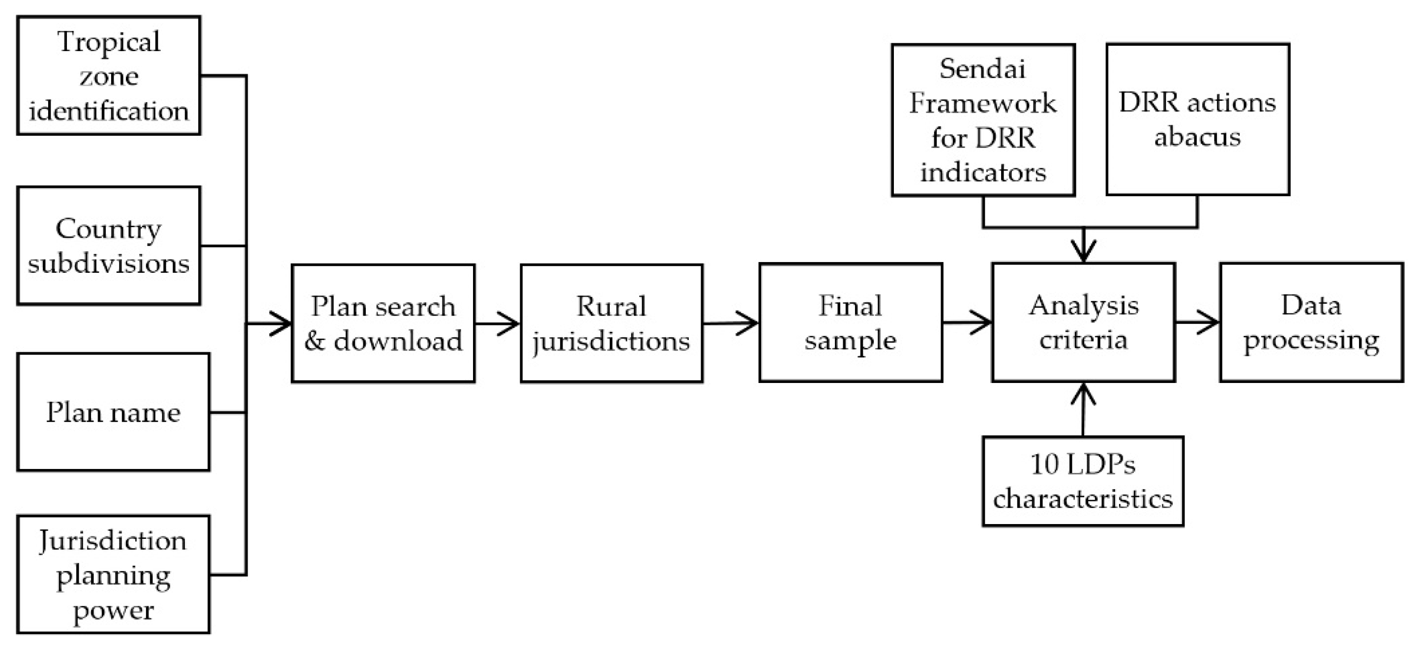
Figure 1.
Flow chart of the assessment.

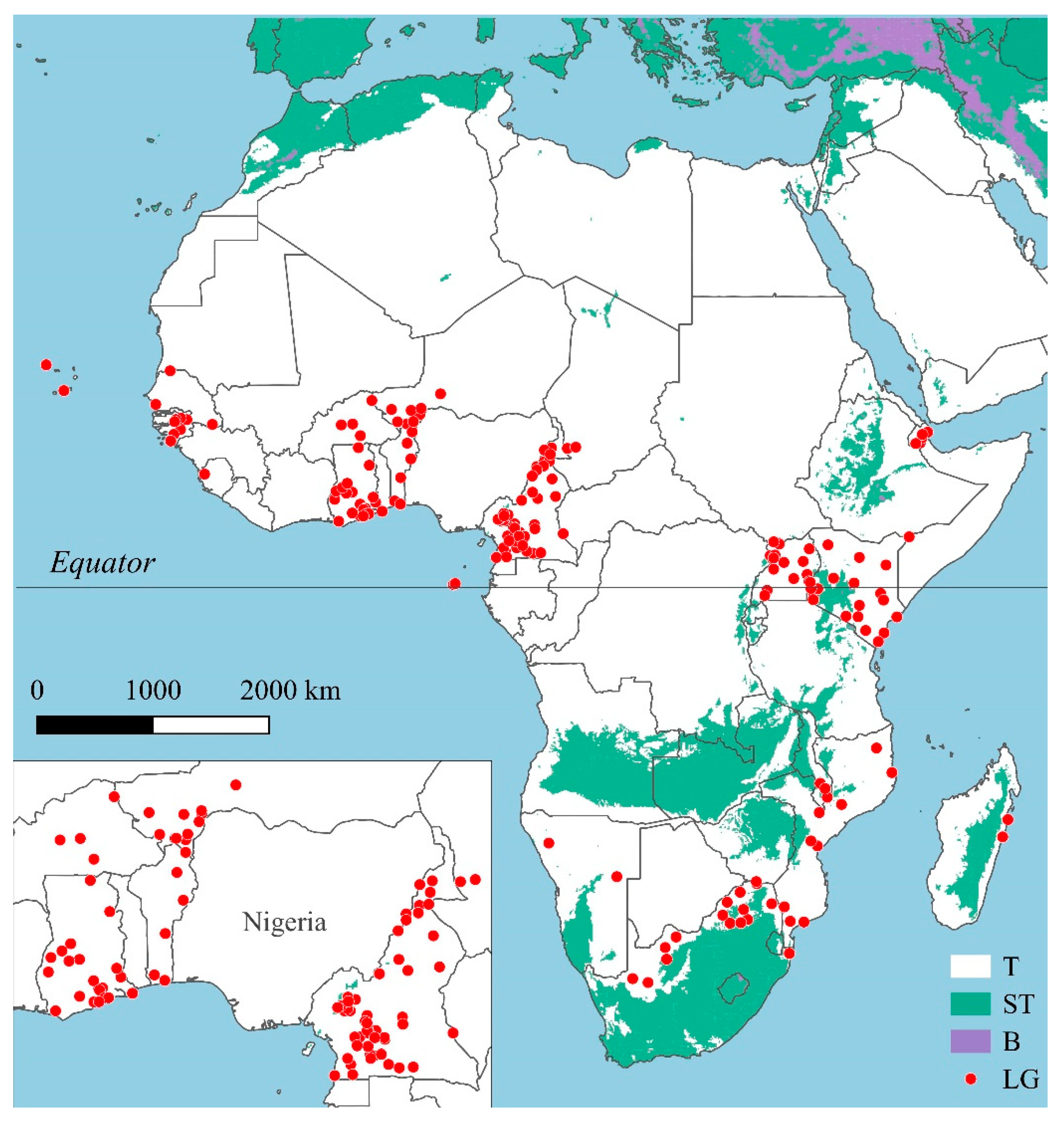
Figure 2.
The 194 local jurisdictions (LG) in the tropical zone (T) with development plans in force and subtropical (ST) and boreal (B) zones.
Figure 2.
The 194 local jurisdictions (LG) in the tropical zone (T) with development plans in force and subtropical (ST) and boreal (B) zones.

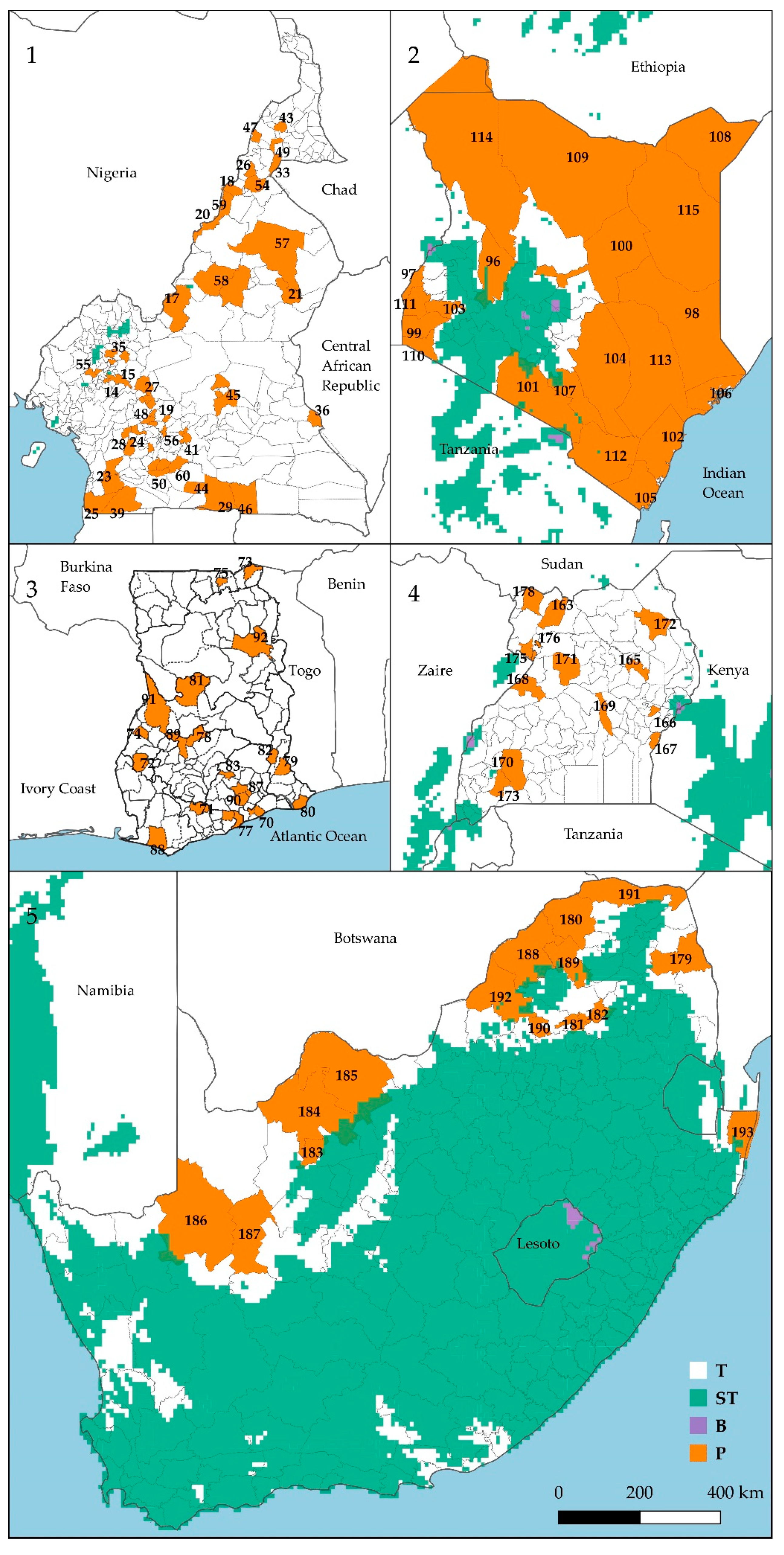
Figure 3.
Cameroon (1), Ghana (3), Kenya (2), South Africa (5), Uganda (4). Ongoing local development plans in tropical zone (P) at September 2019.
Figure 3.
Cameroon (1), Ghana (3), Kenya (2), South Africa (5), Uganda (4). Ongoing local development plans in tropical zone (P) at September 2019.

Figure 4.
Ongoing LDPs (black segments), national disaster risk reduction (DRR) strategies (red dots), and the five years’ time to attend targets of the Sendai framework for DRR.
Figure 4.
Ongoing LDPs (black segments), national disaster risk reduction (DRR) strategies (red dots), and the five years’ time to attend targets of the Sendai framework for DRR.

Figure 5.
Fifty-seven actions explicitly addressed to DRR in 111 LDPs for rural tropical Africa (figures stand for action frequency) and missing actions (red).
Figure 5.
Fifty-seven actions explicitly addressed to DRR in 111 LDPs for rural tropical Africa (figures stand for action frequency) and missing actions (red).

Figure 6.
Consistency of climate change (CC) actions between the planning phases in Cameroun’s LPDs.
Figure 6.
Consistency of climate change (CC) actions between the planning phases in Cameroun’s LPDs.

Figure 7.
Budget (%) for hydro-climatic DRR in 13 African countries.


Table 1.
Local development plans (LDPs) considered in five countries.
| Country | Tropical Rural Jurisdictions | Tropical Rural Jurisdictions with Ongoing LDP | |
|---|---|---|---|
| n. | n. | % | |
| Cameroon | 300 | 52 | 17 |
| Ghana | 46 | 25 | 54 |
| Kenya | 30 | 20 | 67 |
| South Africa | 16 | 15 | 94 |
| Uganda | 137 | 16 | 12 |
Table 2.
Main local climate trends referred by 84 LDPs in rural Africa.
| Climatic trend | Frequency % |
|---|---|
| Temperature increase | 44 |
| Heavy rainfall | 35 |
| Late onset of wet season | 30 |
| Yearly rainfall drop | 30 |
| Rainfall increase | 21 |
| Wet season early end | 21 |
| Air pollution | 12 |
| Dry spells increase | 7 |
| Heat wave | 7 |
| Cyclone | 7 |
Table 3.
Main hazards referred by 176 local development plans in rural Africa.
| Hazard | Frequency % |
|---|---|
| Drought | 56 |
| Strong winds | 38 |
| Bush fire | 29 |
| Flood | 28 |
| Heat wave | 10 |
| Heavy storm | 10 |
| Sea level rise | 8 |
| Lightening | 6 |
| Hailstorm | 5 |
| Dust storm | 3 |
| Salt-water intrusion | 3 |
Table 4.
Most common vision, strategies, and objectives in LDPs for rural Africa.
| Term | Vision % | Strategy % | Objective % |
|---|---|---|---|
| Roads | 42 | 22 | |
| WASH | 29 | 21 | |
| Afforestation | 25 | ||
| Green energy | 25 | ||
| D prevention/response | 24 | ||
| Basic services | 21 | ||
| Electricity | 21 | ||
| Prosperous, wealthy | 20 | ||
| Sustainable development | 15 | ||
| High quality of life | 13 | ||
| Plans n. | 147 | 24 | 67 |
Table 5.
Frequency of risk prevention and preparedness actions in 127 LDPs in tropical Africa.
| Action | Prevention % | Preparedness % |
|---|---|---|
| Afforestation | 50 | |
| Drought tolerant crops | 23 | |
| Boreholes construction | 22 | |
| CC sensitization | 18 | |
| Durable construction materials | 18 | |
| Tree nursery | 14 | |
| Storm water drainage | 12 | |
| Windbreaks | 11 | |
| Agroforestry | 11 | |
| Cattle watering | 11 | |
| Hay cultivation | 10 | |
| Disaster relief | 24 | |
| Early warning system | 24 | |
| Disaster management plan | 18 | |
| Volunteers groups establishment | 16 | |
| Hazard mapping | 10 |
Table 6.
Tools for threat-actions consistency control in 100 LDPs of tropical rural Africa.
| Tool | Plans % |
|---|---|
| Climate trend-impact-solution | 41 |
| Logical framework | 40 |
| SWOT | 30 |
| Strength-weakness | 6 |
| Problems and needs | 5 |
| Assets and constraints | 4 |
| Problems, impacts, needs | 4 |
Table 7.
Public participation in municipal development plans preparation in rural tropical Africa.
| Plan Phase | MDPs | Participation | ||
|---|---|---|---|---|
| Considered | Unknown | Yes | No | |
| n. | n. | % | % | |
| Analysis | 105 | 22 | 81 | 19 |
| Planning | 101 | 43 | 36 | 64 |
| Implementation | 44 | 14 | 70 | 30 |
| M&E | 102 | 42 | 34 | 66 |
Table 8.
Gender participation in the municipal development plans (MDPs) preparation in rural tropical Africa.
Table 8.
Gender participation in the municipal development plans (MDPs) preparation in rural tropical Africa.
| Plan Phase | MDPs | Gender Participation | ||
|---|---|---|---|---|
| Unknown | Known | |||
| n. | n. | n. | % | |
| Analysis | 18 | 13 | 5 | 25 |
| Adoption | 128 | 64 | 64 | 28 |
| M&E | 60 | 34 | 26 | 16 |
© 2020 by the authors. Licensee MDPI, Basel, Switzerland. This article is an open access article distributed under the terms and conditions of the Creative Commons Attribution (CC BY) license (http://creativecommons.org/licenses/by/4.0/).
Share and Cite
MDPI and ACS Style
Tiepolo, M.; Braccio, S. Mainstreaming Disaster Risk Reduction into Local Development Plans for Rural Tropical Africa: A Systematic Assessment. Sustainability 2020, 12, 2196. https://doi.org/10.3390/su12062196
AMA Style
Tiepolo M, Braccio S. Mainstreaming Disaster Risk Reduction into Local Development Plans for Rural Tropical Africa: A Systematic Assessment. Sustainability. 2020; 12(6):2196. https://doi.org/10.3390/su12062196
Chicago/Turabian StyleTiepolo, Maurizio, and Sarah Braccio. 2020. "Mainstreaming Disaster Risk Reduction into Local Development Plans for Rural Tropical Africa: A Systematic Assessment" Sustainability 12, no. 6: 2196. https://doi.org/10.3390/su12062196
Note that from the first issue of 2016, this journal uses article numbers instead of page numbers. See further details here.