The Dynamics of Land Use/Cover and the Statistical Assessment of Cropland Change Drivers in the Kabul River Basin, Afghanistan


1
Institute of Geographic Sciences and Natural Resources Research, Chinese Academy of Sciences, Beijing 100101, China
2
Center for Chinese Agricultural Policy, Chinese Academy of Sciences, Beijing 100101, China
3
University of Chinese Academy of Sciences, Beijing 100049, China
4
National Institute of Rural Development and Panchayati Raj, Hyderabad, 500 030, India
*
Author to whom correspondence should be addressed.
Sustainability 2018, 10(2), 423; https://doi.org/10.3390/su10020423
Submission received: 30 December 2017
/
Revised: 30 January 2018
/
Accepted: 1 February 2018
/
Published: 6 February 2018
(This article belongs to the Special Issue Regional Cooperation for the Sustainable Development and Management in Northeast Asia)
Abstract
:To cope with the growing agrarian crises in Afghanistan, the government (following the fall of the Taliban regime in 2002) has taken measures through cropland expansion “extensification” and switching to mechanized agriculture “intensification”. However, cropland expansion, on one hand, disturbs the existing land use/cover (LULC) and, on other hand, many socio-economic and biophysical factors affect this process. This study was based on the Kabul River Basin to answer two questions: Firstly, what was the change in LULC since 2001 to 2010 and, secondly, what are the drivers of cropland change. We used the spatial calculating model (SCM) for LULC change and binomial logistic regression (BLR) for drivers of cropland change. The net change shows that cropland, grassland, water-bodies, and built-up areas were increased, while forest, unused, and snow/ice areas were decreased. Cropland was expanded by 13%, which was positively affected by low and plain landforms, slope, soil depth, investment on agriculture and distance to the city, while it was negatively affected by plateaus and hill landforms, dry semi-arid, moist semi-arid, and sub-humid zones, precipitation, population, and the distance to roads and water. Climate adaptation measures, cropland protection in flood prone zones, population and rural migration control, farmer access to credit, irrigation, and inputs are necessary for agricultural deployment.
1. Introduction
In Afghanistan, due to weak industrialization, agro-ecosystem services remain as a main source of livelihood and economy. More than 80% of the population of the least developing country is directly or indirectly involved with agriculture and allied activities that contribute 24% to the country’s gross domestic product (GDP) [1]. Furthermore, agriculture accounts for 40% of the active labor force in the country [2]. Agriculture has not been able to meet the food demand of the country despite being a major activity of a large population. Land and water management is the basis for food security and rural economy in Afghanistan. However, following decades of war and instability in the country, the agrarian sector has lost productivity and has become extremely poor. The crisis grows as rapid population growth, coupled with changes in food preferences, further add to the pressure on agricultural production. In the context of this rapid change in land use and related policy implications, this study attempts to analyze the change in land use and land cover (henceforth, LULC) in the Kabul River Basin of Afghanistan. The paper also explores the drivers of cropland change since it is the most critical land-cover in the context of the growing demand for food in Afghanistan.
To cope with the growing agrarian crises and meet with the increasing food demand in Afghanistan, the current governmental setup (following the fall of the Taliban regime in 2002) aimed at improving the local food production through a combination of conversion of non-cropland into cropland “extensification” and switching to mechanized agricultural “intensification”. As per the “National Comprehensive Agriculture Development Priority Program-2016–2020”, the government was committed to further increase the irrigated land from 2.4 million ha to 3.1 million by 2025 [3]. However, the cropland expansion comes at a cost of disturbance to the existing LULC base [4]. Implemented at its simplest form, extensification may convert forest, grass, and rangelands into cropland. For instance, the increase of corn and soybean production in the eastern corn-belt in the USA converted significant grassland into croplands [5]. Agricultural land expansion presents a complicated tradeoff of its services. On one hand, agricultural land provides essential food, feed, and fiber and, on the other hand, in their natural state, these lands could provide additional important ecosystem services, such as terrestrial carbon stock.
There are additional complications because investing in agricultural land expansion is not an easy matter. Many socio-economic and biophysical forces may also affect the LULC base. The rapid urbanization and rapid socio-economic development in some areas would challenge the expansion of cropland. Between 2003 and 2013, the population growth in rural and urban area was 16% and 34%, respectively [6]. Additionally, the influences of ongoing climatic and biophysical changes are likely to change the LULC and may affect the capability of the agro-ecosystem.
In the context of the agrarian crisis, the government priority for cropland expansion and the challenge of urbanization and population growth, this study attempts to answer two questions. Firstly, what was the overall change in LULC base in the last decade since the end of the war and, secondly, what are the significant drivers of cropland change? These questions have gained extreme importance for policy-makers as solving agrarian crises through agricultural land expansion is in conflict with saving these lands for other kind of ecosystem utility such as forest covers. Due to the lack of scientific data and trained researchers that resulted from decades of war, the existing scientific studies on LULC change patterns and assessment of the related driving forces are negligible in Afghanistan. On the contrary, worldwide, there have been many studies on the assessment of LULC change and the associated driving factors. Particularly, econometric and theoretical economics have been widely used for this reason [7,8,9,10].
Land is considered to be a limited resource with an economic value. The use of land, which is affected by several socio-economic and geophysical factors, determines the value of land. Theoretically, the change of use of land from one to another would follow the demand and supply theory of markets [11,12]. Under the full market competition condition, the conversion of a land use from one type to another will continue until the marginal benefit (MB) and marginal cost (MC) curves of land use change intersect each other. To trace the contribution of different socio-economic and biophysical factors in land use change (i.e., from one value to another), researchers use different models, such as regression, and machine learning algorithms, such as support vector machines (SVM) [13,14,15,16,17]. LULC change models deal with land issues that range from simple system representations to simulation systems based on a deep understanding of situation-specific problems with consideration of a large number of drivers at different spatio-temporal scales [18,19,20]. There are simulation-based methodologies, such as cellular automata models, which apply complex sets of rules accounting for possibilities of transition of urban land-use to random human behavioral changes in modeling LULC change [21]. However, due to the flexibility of too much modification and the lack of standard rules of transition, cellular automata models are mostly used in academic practice. Recently, many researchers have focused on calibration modeling, as it has defined transition rules that accurately represent the evaluation of past land uses [21]. Traditionally there are two ways of calibration modeling—(1) trial and error based method; and (2) statistical techniques [21,22]. From statistical techniques, the regression modeling is most commonly used [16]. Although the recent simulation models are precise in dealing with small details of LULC change, the statistical regression models are easier in practice and can deal with spatiotemporal changes of land systems in accordance with the changes of driving forces with a fair degree of precision [23]. Within the regression modeling, there are two particular approaches in assessing the spatial dependency—firstly, autoregressive structure (consisting of many models) and, secondly, spatial sampling of plots [24]. In spatial samplings, logistic regression modeling is one of the most utilized approaches in recent years, particularly when predicting land uses [13,16,17].
When, in logistic regression, the dependent variable has two possible outcomes it is called binary logistic and when the possible outcomes are more than two, it is called multinomial logistic regression [25,26]. In the case of binary analysis, based on the understanding of random utility and profit maximization theory of land, the change of land use can be linked with the drivers of change [14,15,27,28].
A large number of the researchers have applied binomial logistic models using four categories of factors as independent variables explaining LULC change—namely, climatic, biophysical, socio-economic, and neighboring factors [29,30,31]. For instance, Arowolo and Deng used the binomial logistic regression (BRL) model for analyzing the factors of agricultural land use change in Nigeria between the time periods of 2000 to 2010 [29]. Since the outcomes of dependent variables are unobserved and discrete, the ordinary least square (OLS) is not suitable; therefore, the maximum likelihood (ML) method in logistic modeling is used [29].
In some of the cases when dealing with high correlation problem amongst the predictors, other models such as principal component analysis (PCA), general linear model (GLM) [32], and ridge regression method were used for assessment of land use change [33]. In Afghanistan, the impact of war and institutional changes on LULC changes have been studied by selecting four governance periods and comparing the LULC change across and within those periods [34]. Considering the high environmental heterogeneity and the socio-economic turbulence in Afghanistan, the study suggested separate zone-wise LULC studies.
In view of the given importance of agro-ecosystem services, and the unprecedented impact of climatic and socio-economic changes on cropland use in the coming decades in Afghanistan, this study was, therefore, designed to assess LULC change and the related drivers of cropland expansion. Utilizing the existent literature on LULC change modeling, this study attempted to apply such models in the data-scarce situation of Afghanistan and fill the research gap. This study considered the high spatial environmental and socioeconomic variability in Afghanistan for analyzing the LULC, as earlier suggested by De beurs and Geoffrey [34]. This study selected the Kabul River Basin (KRB), the eastern region of Afghanistan, as the study area to investigate the LULC change and the related driving forces of cropland change.
2. Data and Methodology
2.1. Study Area
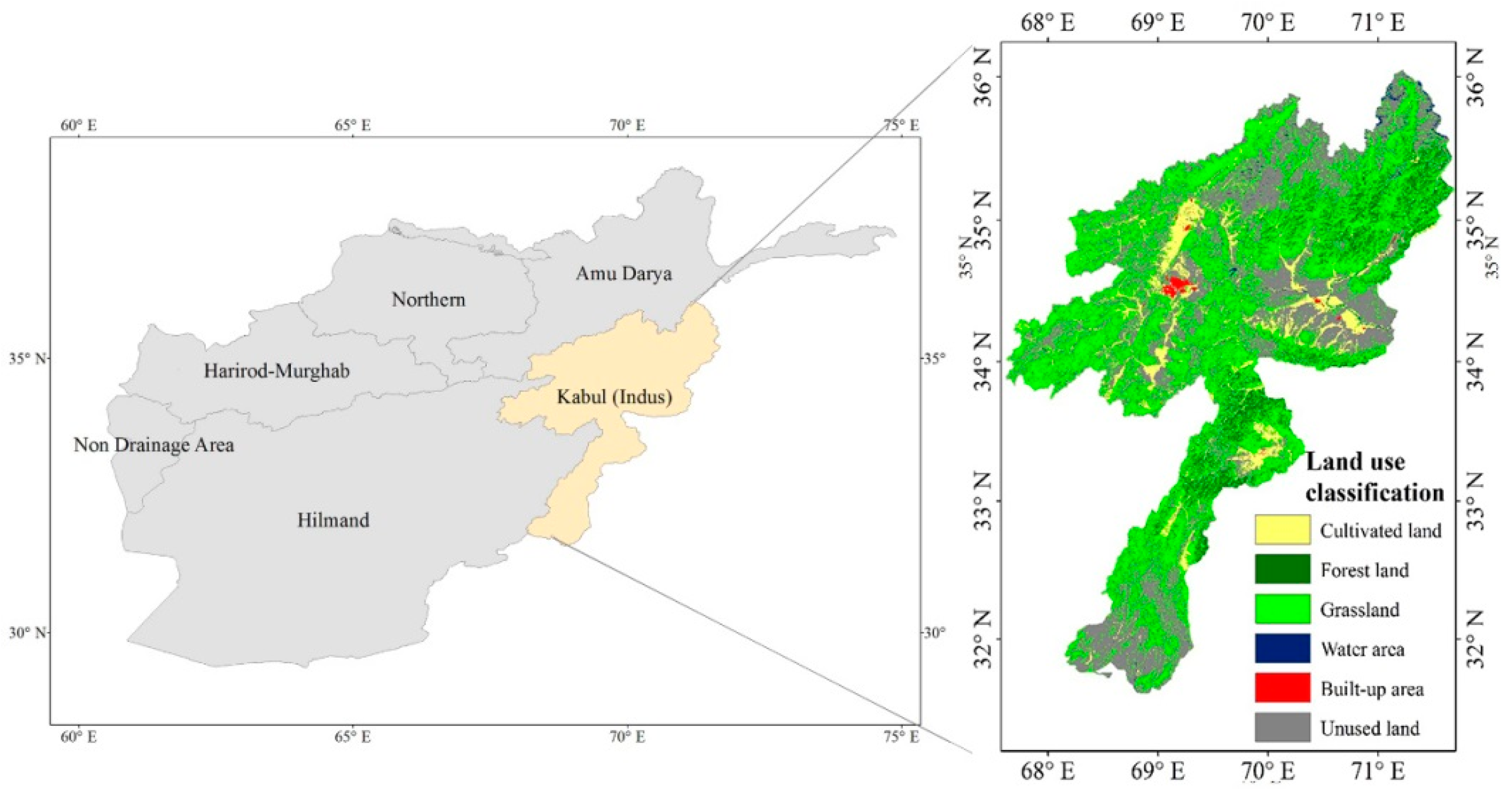
Afghanistan is located in a semi-dry region where the winter snowfall in high-altitude mountains are the origins of life-supporting river systems. The river systems divide the country into five major basins, namely; he Amu Darya Basin, the Western River Basin, the Helmand River Basin, the Northern River Basin, and the Kabul River Basin (KRB). This research was conducted along the KRB in Afghanistan (Figure 1). The river originates from the northern mountains in Afghanistan and after passing through 700 km, it finally flows to the Indus River in Pakistan [35]. Within Afghanistan, this river flows though many provinces and covers an area of 63,000 km2. The hydrological and physiographical characteristics divide the river basin into three sub-basins of Panjshir, Upper Kabul, and Lower Kabul. The rainfall during spring and winter seasons derives the Upper Kabul (Logar), whereas the summer snow melt mostly fed the Panjshir River [36]. The significant topographical variation, ranging from 420 m above the sea level to 6000 m above the sea level, characterizes the KRB. The lowlands, the most suitable land for agriculture, are mainly located in the central and eastern parts of the KRB, whereas, the northern part contains the high-elevation mountains [37]. Moreover, the KRB is also characterized by high spatial variation in mean annual temperature and precipitation. The monthly average precipitation and temperature is about 13 °C and 33 mm, respectively [37,38]. However, the precipitation in the northern Hindu Kush Mountains reaches approximately 160 mm/month.
The river basin is also considered the most critical region for its socio-economic indicators. Almost one fourth of the country’s settlements and one third of the total population live in this basin, three times denser than the other four river basins [1]. Some of the major cities, such as Kabul and Jalalabad, are located in this river basin. Agriculture and livestock are the main source of livelihoods in the KRB. Agriculture is largely irrigated and shares around one-fifth of the total irrigated land in the country. The river basin also holds around two-thirds of the total forest resources in the country [39].
2.2. Data Handling
The data used in this study was collected from different secondary sources. The study used several datasets of LULC, socio-economic, and biophysical factors to assess the land use change and the associated determinants of cropland expansion. The LULC, socio-economic, and climate data used in this study were required for the years 2000 and 2010, while the biophysical and neighboring factors, i.e., AEZs, landforms, soil parameters, slope, elevation, distance to city, distance to water, and distance to road networks, as they are assumed constant in shorter period of time, were required as one point data. Additionally, all of the data used in this study were required in gridded maps format. Some of the socio-economic parameters, however, were not available in the form of desired gridded maps or resolution. To cope with this, GIS techniques to interpolate tabulated data and produce gridded maps were used. In order to conduct regression analysis, using GIS 10.2 software (ESRI, Redland, CA, USA) [40], all the data was reassembled to 250 m × 250 m resolutions. Below this resolution, the software was unable to support the large pixel number. The description and source of each data is presented in the subsequent discussion.
2.2.1. Preparation of Biophysical Data
The 30 × 30 m LULC data was derived from the online source of www.globallandcover.com [41]. The overall classification accuracy of this data is 84% and the Kappa value is 0.78 [41]. The descriptions of LULC are presented in Table 1. The topographical aspect data, i.e., slope and elevation were derived from the Shuttle Radar Topography Mission-Digital Elevation Model (SRTM-DEM) which is available online http://srtm.csi.cgiar.org [42]. Similarly, the soil aspects were collected from International Soil Reference and Information Center (ISRIC) www.soilgrids.org [43]. The overall validation accuracy of the used models for soil properties mapping is 61% [44].
2.2.2. Climatic Data
To capture the impact of climatic factors on cropland expansion, the monthly average temperature and precipitation data was utilized in this study, similar to what was used elsewhere [45,46]. The station-based data were acquired from the Ministry of Agriculture, Afghanistan. To further estimate the impact of climate factors at pixel level, GIS software was used to produce the gridded maps of both temperature and precipitation. For this reason, the Kriging spatial interpolation method was adopted. The similar interpolation method was suggested by earlier studies [47,48,49,50].
2.2.3. Socio-Economic Data
Land use change drivers are defined as underlying and proximate [51]. The systematic and structural contact of human with ecosystem reflected by underlying drivers, representing accessibility to technologies, land, information and manpower, lead to human activities and proximate causes of LULC change [52]. The increasing human population and their activities, leading to rapid urbanization and industrialization, continue to pressurize LULC base [33,53,54]. Therefore, the appropriate selection and accurate measurement of the impact of socio-economic factors in land use change modeling remained vital for defining the potential change and avoiding the uncertainty in future planning [33]. Based on the research objectives, methodological techniques and data availability, researchers have used a variety of variables. The study of Deal and Pan [55] specifically mentioned that the socioeconomic factors, such as economic development, demographic distributions, and human mobility interact with the dynamics of LUC processes. Therefore, the economic parameters (such as GDP), spatial interactions of neighboring parameters (such as roads, cities, and water), and most importantly population distribution are the most commonly used socio-economic parameters in LULC modeling [29,55,56,57,58]. Based on our study objectives and the data accessibility, we have also used the above factors to understand the socio-economic impact on land use land cover change. As the make-up and impact of the driving forces of LULC may not be the same across regions [59,60], we needed to apply various data processing techniques in order to prepare the spatial layer of socio-economic data.
The pixel level population data for the years of 2000 and 2010 was obtained from the online source of www.worldpop.org.uk [61]. The spatial influence of neighboring factors, i.e., the distance to major cities, water, and roads are, on one hand, considered important for agricultural development and, on other hand, they also attract non-agricultural activities in the area, pressuring agricultural lands. To capture the influence of neighboring factors on cropland change, this study used the distance of cropland from city, roads and water. To measure distance from the city, the coordinates of provincial offices (as a proxy of city center) were identified by using Google Earth Pro software (Mountain View, CA, USA) [62]. Secondly, the Euclidian distance function of the GIS software was used to produce 250 m × 250 m pixel maps of the distance from the provincial capital city. A similar process was also applied to estimate the distance of each pixel from water and roads networks. The shapefiles of water lines and roads were acquired from the online source www.diva-gis.org [63]. Then the Euclidian distance function of GIS software was applied and produced the 250 m × 250 m maps of the distance to roads networks and the distance to water lines.
To assess the impact of economic growth on cropland use change, many researchers have used Gross Domestic Product (GDP) as a proxy. However, due to the lack of GDP data at the small scale in Afghanistan, the percentage poverty and the per hectare governmental investment on agriculture in each province were used as proxies to economic power. The tabulated data of the poverty percentage and investment on agricultural development were obtained from the website of the Central Statistical Organization (CSO). The spline interpolation algorithm function of GIS was applied on these tabulated data and produced 250 m × 250 m gridded maps, similar to the method that was used elsewhere [37].
2.3. Analytical Tools and Equations
The two main questions of the study were analyzed by first evaluating the change rate of different types of LULC in the KRB and then analyzing the magnitude of the impact of driving forces of LULC change on cropland change.
2.3.1. Evaluating the Land Use Change Rate
To calculate the land use change rate in the KRB, the spatial calculating model (SCM) was used [64]. To apply the model, seven types of land-use were identified viz. cropland (1); forest (2); grassland (3); water bodies (4); built-up land (5); unused land (6); and snow or ice (7) for the base year i.e., 2000, and final year, i.e., 2010. Land-use of 2000 was cross tabulated with that of 2010 to derive a Land-use transition matrix. The change rate of land was derived applying the following equation:
where is the change rate of land during the given time period, i.e., from first time period to second time period; T1 is 2000 and T2 is 2010.
i varies from 1 to 7 depending on the type of land-use.
and represent the pixels/area of i type of land at the years of t1 and t2 respectively; and
The term is derived from the diagonal elements in the land-use change matrix (Table 3) and represents the total unchanged pixels/area of i type land during this period.
In the equation, the terms and depict the converted (the decreased part) and gained (the increased part) of i type land to/from other types of lands respectively;
The terms and show the annual decreasing and increasing percentage of change in a land-use type.
The traditional ordinary analysis models by Bruce and Maurice and the single spatial information analysis model by Liu et al. were also commonly used methods [65,66]. However, the SCM models provide the complete information about decreasing and increasing rates of LULC change. The traditional model ignores both decreasing and increasing rates and simply calculates the annual change rate, and the single spatial information model also only considers the conversion (decrease) of land use type and ignores the gained (increase) part. As opposed to them, the SCM accounts for both decreasing and increasing rates of changes in analyzing the land use change. The model also provides the scope to decompose the overall land-use change into various types of land-use and allows for a relevant policy analysis.
2.3.2. Analysis of Driving Forces of Cropland Change
Land use change can be defined as a response to the changes in the possible driving forces of LULC, such as socioeconomic, biophysical, demographic, and climatic forces. Some recent analyses have implemented the land-use evolution and impact assessment model (LEAM) planning support system (PSS) to provide detailed information and policy solutions to planners [58]. The PSS models essentially estimate the environmental impacts of land-use change by controlling a large number of confounding factors of land-use change. The regression models, however, provide a simpler estimation approach by helping parcel out the individual impacts of the predictors. In this analysis, the regression approach was used to identify the significant drivers of land-use change and by analyzing the potential driving forces of cropland expansion; we sought to statistically understand the magnitude of significant impact of different factors on cropland expansion. To avoid multicollinearity amongst the independent variables, a multicollinearity test was conducted. For this purpose, the variance inflation factor (VIF) analysis [29,67] was used. Based on VIF analyses, each independent variable (factor) was linearly regressed against other independent variables (factors). An independent variable with VIF value acceding 10 was considered as serious multicolinearity problem that requires the removal from the analysis. Furthermore, to enhance the computational accuracy, the continuous variable standardization to have a zero mean and unit standardization were also conducted. The descriptions of final selected variables are given in the Table 2.
2.3.3. The Econometric Modeling of Cropland Change
The study applied the binary logistic regression (BLR) model to statistically test the LULC factors with emphasis on the probability that a given area converted to cropland depends on the variation in the hypothesized independent variables. The BLR model was first introduced by Cox, Walker, and Duncan [68,69]. The model uses the maximum likelihood (ML) method and predicts the probability of dependent variable ‘Y’ being 1 given with values of vector X (i.e., independent variables). Since the dependent variable Y takes only two values and cannot exceed 1 or fall below zero, therefore, it is an exponential function rather than a linear function. In this study, if a given location (k) changed to cropland, then Y holds the value of 1, otherwise it holds zero. The equation of the binomial logistic regression model is given as follows:
where, Yk = refers to land use at location (k) (if land use change to cropland Y = 1, while Y = 0 is otherwise); β0 is constant; βi (i = 1~n) are the estimated model coefficients; Xi (i = 1~n) are the independent variables and, lastly, μ is a random error term.
Yk(2000−2010) = β0 + β1X1 + β2X2 + β3X3 + …… βnXn + μ
3. Result and Discussion
3.1. Land Use Change
3.1.1. Land Use Change Direction
Table 3 represents the direction of land use change in KRB from 2000 to 2010. The transition matrix understandably reveals that during the study period, cropland and built-up areas were found with the lowest conversion, i.e., less than 5% of the total land in the year 2000, representing 95% of the stable area. On the other hand, forest and water bodies were significantly unstable. During this period, 41.4% of total forest area and 46.9% of water bodies were converted to other LULC types. Grassland, permanent snow/ice, and unused lands were also noticeably unstable with 17.4%, 84.8%, and 24.1% of converted areas, respectively.
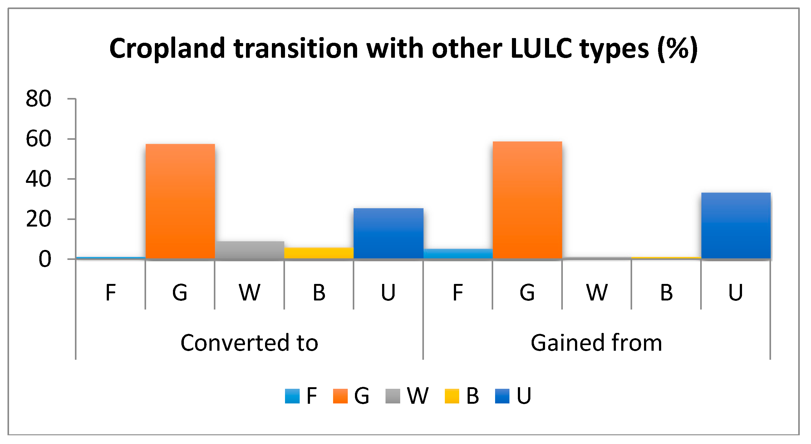
The significant exchange of cropland in KRB happened after 2000 with all the land use types, particularly with grassland, unused land, water bodies, and built-up land. More than 80% of the converted cropland was shared by grassland and unused land (Figure 2). This was possibly due to the water stress situation in some parts of the country due to climate change, as indicated by Savage et al. [70]. The remaining areas of cropland conversion are mostly shared by water bodies and built-up, indicating that the cropland were damages by flood and increasing urbanization. As for the gained part, cropland mainly gained areas from grassland, unused land, and forest implying that the agricultural expansion happened with expenses to the natural lands, such as grasslands and forest areas.
3.1.2. Land Use Change Magnitude
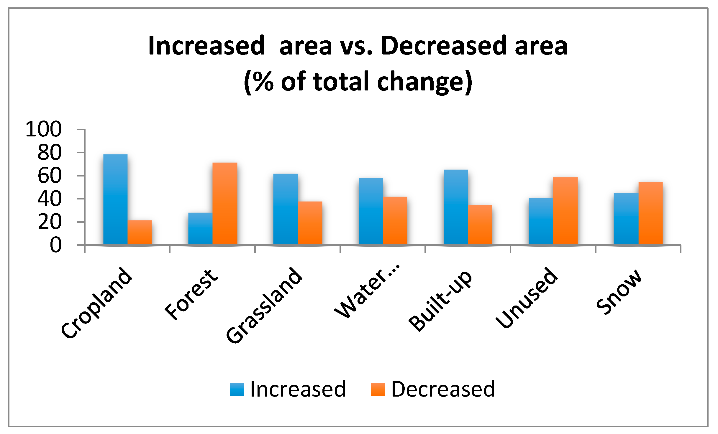
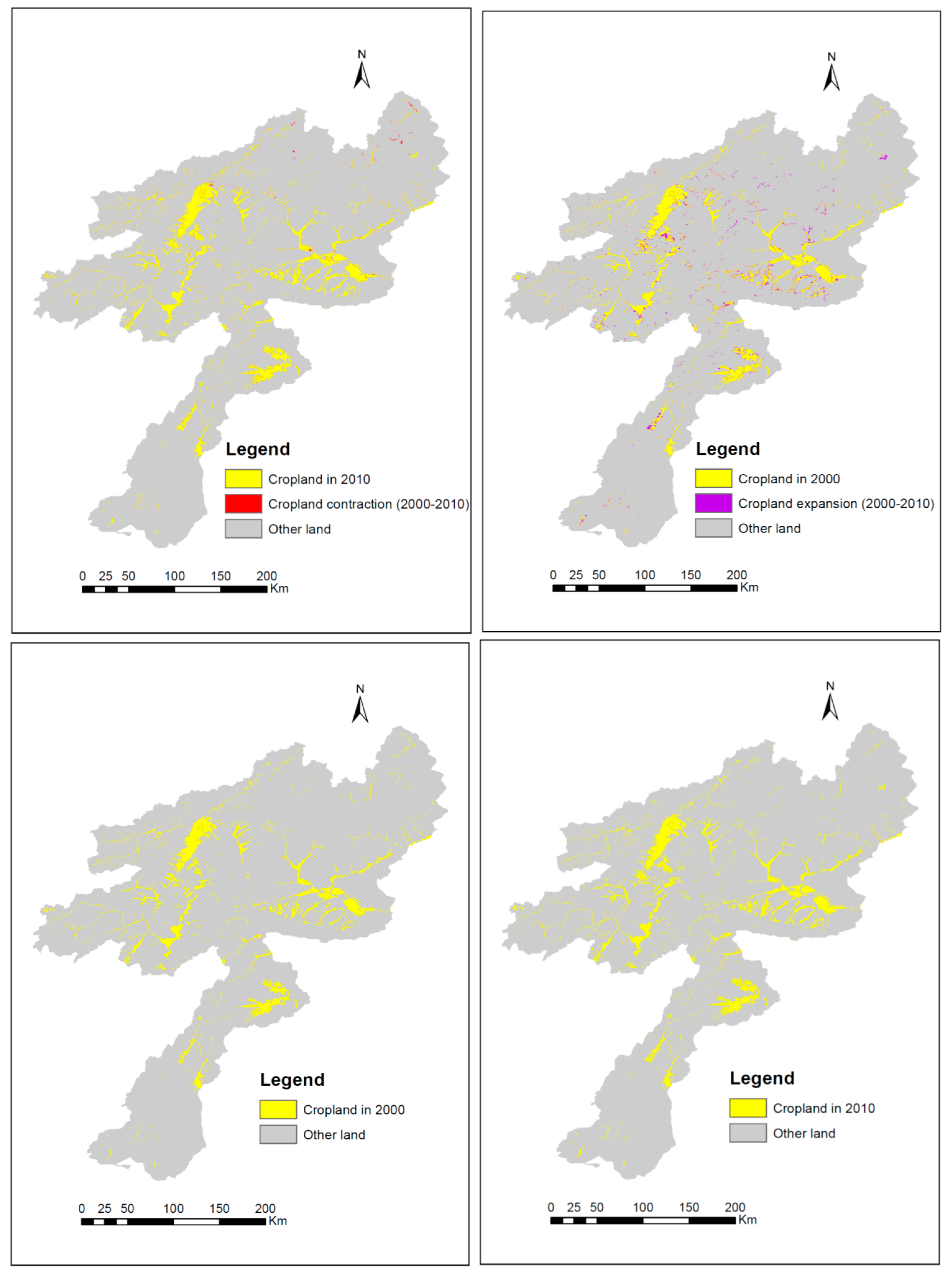
The magnitude of land use change is described in Table 4 and Figure 3. During the period from 2000 to 2010, an area of 31,331 ha of cropland decreased, while 114,044 ha increased, respectively, sharing 4.3% and 15.7% of total cropland area in 2010. This indicates that the size of increased cropland was 11.4% higher than the size of decreased cropland. The decrease is significant, as also confirmed by rate of change, which was 0.5% for the decrease, compared to 1.8% for the increase, of cropland (the spatial distribution of cropland can be seen in Figure 4). The main reason behind this could be the large investment of government on irrigation projects during this period [3,71]. Currently this basin shares about 20% of the total irrigation land in Afghanistan.
On the other hand, the rate of decrease of forest areas (i.e., 5.8%) was about three times higher than the rate of increase (i.e., 1.6%), resulting in a decline of forest covers. The previous studies on Afghanistan’s forest change also confirm the rapid rate of forest cover decrease [72,73,74]. Use of wood for fuel and heating, illegal smuggling, instability in the forest-dominant areas, weak management, and urban and cropland expansion were considered to be the main drivers of deforestation [39,71,73]. However, the study of Reddy and Saranya [72] showed a declining trend in the deforestation rate in recent years. This could be due to increased conservation measures that have been taken recently. Permanent snow/ice covered land and unused land were also amongst the LULC types that were more on the decline. This is in consistent with previous studies at regional and national scales [74,75]. The decreasing and increasing rates of snow/ice covered land were 1.5% and 1.3%, respectively. The reason behind the shrinking snow/ice covered area could be the increasing temperature that has resulted from global warming, as indicated by Savage et al. [70]. The rapid melting of the snow/ice covered area went hand in hand with the increase in water areas. Haritashya et al., in their study, reported that the decrease of glaciers due to the changing climate conditions had resulted in the formation of high-altitude lakes, and increased the size of existing glacial lakes [75]. There was an increase in water bodies of 1,272,013 ha (55% of 2010) against a decrease of 779,075 ha (39.7% of 2010), resulting in a 6.5% increasing and 4.7% decreasing rate, respectively.
The overall rate of change during the study period shows that water bodies and forest areas had changed the most, with 11.2% and 5.7% of rates of change, respectively. They were followed by unused land (4.5%), grassland (4.1%), snow/ice covered areas (2.8%), cropland (2.3%), and built-up areas (1.4%). The annual net change rate of cropland, grassland, water bodies, and built-up land were positive, whereas the annual net change rate of, forest, unused, and snow/ice covered area were negative.
3.2. Cropland Use Change Drivers
From the multicollinearity diagnostic analysis we determined that, except for the variable of mountainlandforms, all other variables were not highly correlated. Agricultural practice was also negligible in mountainous areas of the KRB. Therefore, the mentioned variable was eliminated from the model. Table 5 shows the maximum likelihood of the variables that are included in the model. The figure for the area under the ROC curve (AUC) in the table is 0.83, which shows a very good explanatory power of the chosen variables for explaining the cropland expansion. The result of the BLR revealed that both biophysical and socio-economic factors are important in driving the cropland expansion. From the terrain variables, the impacts of lowlands and plains on cropland expansion were highly significant at the 1% level of significance. The impact of plateaus was significant at 5%, while the cropland expansion was non-significant in the mountains. Odds ratios suggested that the cropland expansion in plains and lowlands are, respectively, 1.3 and 1.6 times more likely than the plateaus. This was in line with the fact that agriculture in the KRB is mostly irrigated, which is practiced in the lowlands and plains where river water can be easily diverted for irrigation. As Afghanistan is located in a harsh climatic region of a semi-arid zone, the agro-ecological conditions show an inverse relationship with the cropland expansion. The likelihood of cropland expansion will be reduced with the increase in any of the AEZs, except the humid AEZ. The elevation impact on cropland expansion was negative, while the slope impact was positive. This is because the high elevated areas of KRB are mostly frozen throughout the year and covered by snow, which restricts agriculture. With the increase of each unit of slope and elevation the likelihood of cropland expansion increased by 1%. This reveals that the agricultural expansion has mostly happened in the sloped and low altitude areas, i.e., lowlands and plains. The impact of temperature was insignificant on cropland expansion, however, precipitation showed a negative relationship with the expansion of cropland. Theoretically, this seems to be against the expectations in a dry climate country. However, the possible reason for this could be the spatial differences between the distribution of precipitation and agricultural lands in the KRB. Precipitation in the KRB mostly occurs in the form of snow in high-altitude areas, which later melted into rivers and flow towards the lowlands and plains to irrigate the agricultural lands. The areas with more precipitation (snow) are normally frozen for a major part of the year and, hence, unsuitable for agriculture. The recent study of the National Environmental Protection Agency Afghanistan (NEPA) and the United Nation Environment (UN Environment) reported that the increasing seasonal variation of precipitation has adversely affected agriculture. As per the study, the winter precipitation (which mostly occurs in the form of snow) had shown an increase, while the spring precipitation (directly facilitating crops) had decreased [76]. Additionally, the increasing pattern of intense and irregular rain causes flash floods in the lowlands of the KRB, which subsequently damaged the agricultural lands [70,71].
Apart from biophysical factors, socio-economic factors, such as economic development, population growth, government investment on agricultural development, and access to roads and economic infrastructure, are also important factors of LULC change. The empirical analysis of our model showed an inverse relationship of population density and cropland expansion. The model predicted that with the increase of one unit of population density, the likelihood of cropland expansion decreased by 1%. Increasing competition between built-up land and cropland, particularly along the highly-populated areas (i.e., cities), has led to restrictions on further expansion of crop-lands. As most of the KRB is covered by mountainous regions, the land for agriculture, housing, and other non-agricultural activities is limited. Therefore, to meet the demand of rapidly-growing population and urbanization, the agricultural lands are being converted to built-up lands [39]. This study used poverty rates as a proxy for the economic ability of the region to invest on non-agricultural economic activities, while the investment on agriculture was used to understand the impact of government funding on cropland expansion. The BLR model predicted that cropland expansion has a non-significant relationship with poverty, while the relationship with agricultural investment was significantly positive. With each unit increase of agricultural investment, the likelihood of cropland expansion increased by 2%, suggesting that agricultural still remains as a main economic activity in the KRB. The industrial setup is still weak in the country and 40% of the active labor force is engaged in agriculture. Investment on irrigation schemes to bring new lands under cultivation is one of the main foci of the government and it was evident by the result of the model.
Regarding the proximity variables, the distance to the city showed a positive relationship with cropland expansion, whereas the relationship was negative with the distance to roads and water networks. The odds showed a marginal increment of likelihood of cropland expansion (i.e., less than 1%) if a unit of distance to cities increased. The positive relationship of city distance means the lands in the city and nearby areas are mostly occupied by manmade artificial lands. The negative relationship of cropland with the distance to roads and water indicates that the existence of river networks and market connectivity played important role in cropland expansion.
4. Conclusions
In Afghanistan, monitoring land use change dynamics and its related deriving forces are critical for efficient management of land resources. In the past few years, considering the large investment of government on agricultural land expansion in the given context, the rapidly growing population and urbanization have further added to the importance of land use change studies. To serve the above purpose, this study was conducted to spatiotemporally examine the dynamics of LULC and evaluate the determinants of cropland expansion in the most populated river basin of Afghanistan. The result of the spatial calculating model (SCM) showed that all the LULC classes were significantly changed during the period of 2000 to 2010. Particularly the water areas, forests, unused and grassland were significantly converted. On the contrary, built-up land and cropland were the most stable classes with less than 5% conversion. However, the net change rate showed that, during this period, cropland (13%), grassland (11%), water bodies (18%), and built-up land (4%) increased in percentage, whereas forest (25%), unused (7%), and snow/ice covered areas (3%) decreased. The rate of loss was highest for forests. The main reasons for massive deforestation are uses of wood for fuel, heating, and housing, as well as illegal smuggling [39,72,73].
The cropland expansion was found to be driven by several biophysical, socio-economic, and neighborhood factors. Low and plain landforms, slope, soil depth, investment on agricultural development, and distance to the city positively affected the cropland expansion, while plateaus and hill landforms, dry semi-arid, moist semi-arid, and sub-humid AEZs, precipitation, population, and the distance to roads and water negatively affected the cropland expansion.
From the study, some impending crises from changing LULC and agrarian development have been observed and related to this change, and several policy recommendations can be drawn. Firstly, given the rapid loss of forests, the government needs to take measures to regulate forest exploitation. The provision of alternative fuel sources for cooking and heating, together with educating the local communities about the importance of forest resources, would help to decrease the rapid deforestation. Moreover, the government should implement afforestation and reforestation programs in the potentially suitable and available lands. Secondly, the shrink of snow/ice covered areas are threatening future water security in the KRB. Suitable measures need to be taken to optimize water utilization both through constructing water reservoirs and enhancing water use productivity and efficiency. Thirdly, the negative relationship of precipitation and cropland expansion indicated that climate adaptation measures are important to tackle with increasing irregular precipitation patterns. As in the KRB most of the croplands are located along the riverside, therefore, protected river embankments may help to protect croplands in the flood-prone zones. In Afghanistan most of the agriculture is irrigated and gets it water from the nearby river networks. Thus, investment on irrigation networks will be important for agricultural expansion in the future. Fourthly, the negative relationship of cropland expansion with the distance to road networks reveals the importance of market access for agricultural development. Being a mountainous country, the road networks in rural areas of Afghanistan have not been well developed and farmers have low access to market hubs. With the development of road networks, farmer can be directly connected with the local and international market hubs, which will increase their farm business returns and allow them to spend on additional irrigation. Without a focus on road networks, investment on irrigation could go to waste. Therefore, along with the investment on access to land and water resources, investment on the construction of roads is equally important for agricultural land expansion. Fifthly, the productive agricultural fields in the outskirts of populated cities are threatened by a rapidly-growing population and urbanization. A balance in population growth and the provision of needed facilities in the rural areas would help to control the rapid urbanization and cropland conversion. Finally, the positive relationship between government investment on the agricultural sector and cropland expansion suggests that the increased funding in the agricultural sector for enhancing farmers’ access to secure agricultural lands, agricultural credit, irrigation facilities, and farm inputs are necessary for agricultural development.
The factors considered in this study are limited to the data available. There may have been some unseen driving factors that impacted the cropland changes during the study period. For this, future research needs to develop more datasets and select shorter time periods. Additionally, this research only focused on LULC changes and not its consequences in terms of economics and the environment. As such, further studies are needed to investigate the economic and environmental implication of cropland expansion.
Acknowledgments
This research was financially supported by the National Key Research and Development Program of China (grant No. 2016YFA 0602500), China National Natural Science Funds for Distinguished Young Scholar (grant No. 71225005), the Bureau of International Cooperation, Chinese Academy of Sciences (grant no. 131A11KYSB 20130023), and the CAS-TWAS President Fellowship Program.
Author Contributions
In this article, Omaid Najmuddin contributed in formulating research design and organizing the research flow, preparation of data, analysis and interpretation; Xiangzheng Deng contributed to the analysis of results and interpretation; Ruchira Bhattacharya contributed in interpretation of results and designing the article writing.
Conflicts of Interest
The authors declare no conflict of interest.
References
- Government of Afghanistan (GoA). National Accounts in Statistical Year Book 2016; CSO, Government of Afghanistan (GoA): Kabul, Afghanistan, 2016. Available online: www.cso.gov.af (accessed on 20 February 2017).
- National Risk and Vulnerability Assessment (NRVA). National Risk and Vulnerability Assessment 2011; Government of Afghanistan (GoA): Kabul, Afghanistan, 2011. Available online: http://www.af.undp.org (accessed on 15 January 2017).
- Government of Afghanistan (GoA). National Comprehensive Agriculture Development Priority Program 2016–2020; Government of Afghanistan (GoA): Kabul, Afghanistan, 2017.
- Grundy, M.J.; Bryan, B.A.; Nolan, M.; Battaglia, M.; Hatfield-Dodds, S.; Connor, J.D.; Keating, B.A. Scenarios for Australian agricultural production and land use to 2050. Agric. Syst. 2016, 142, 70–83. [Google Scholar] [CrossRef]
- Ren, J.; Campbell, J.B.; Shao, Y. Spatial and temporal dimensions of agricultural land use changes, 2001–2012, East-Central Iowa. Agric. Syst. 2016, 148, 149–158. [Google Scholar] [CrossRef]
- Government of Afghanistan (GoA). Demographic and Social Statistics, Population; CSO, Government of Afghanistan (GoA): Kabul, Afghanistan, 2016. Available online: http://cso.gov.af/en/page/1500/4722/2015-2016 (accessed on 20 January 2017).
- Lambin, E.F. Modeling and monitoring land-cover change processes in tropical regions. Prog. Phys. Geogr. 1997, 21, 375–393. [Google Scholar] [CrossRef]
- Serneels, S.; Lambin, E. Proximate Causes of Land Use Change in Narok District Kenya: A Spatial Statistical Model. Agric. Ecosyst. Environ. 2001, 85, 65–82. [Google Scholar] [CrossRef]
- Veldkamp, A.; Fresco, L.O. Exploring Land Use Scenarios, an Alternative Approach Based on Actual Land Use. Agric. Syst. 1997, 55, 1–17. [Google Scholar] [CrossRef]
- Verburg, P.H.; Soepboer, W.; Veldkamp, A.; Limpiada, R.; Espaldon, V.; Mastura, S.S.A. Modeling the Spatial Dynamics of Regional Land Use: The CLUE-S Model. Environ. Manag. 2002, 30, 391–405. [Google Scholar] [CrossRef] [PubMed]
- Houghton, R.A. The worldwide extent of land-use change. BioScience 1994, 44, 305–313. [Google Scholar] [CrossRef]
- Dai, E.F. Study on Sustainable Land Use: Systematic Analysis, Assessment and Management Approaches. Ph.D Thesis, Peking University, Beijing, China, 2002. Unpublished. [Google Scholar]
- Arsanjani, J.J.; Helbich, M.; Kainz, W.; Boloorani, A.D. Integration of logistic regression, Markov chain and cellular automata models to simulate urban expansion. Int. J. Appl. Earth Obs. Geoinform. 2013, 21, 265–275. [Google Scholar] [CrossRef]
- Alabi, M.O. Analytical Approach to Examining Drivers of Residential Land Use Development in Lokoja, Nigeria. Br. J. Educ. Res. 2011, 1, 144–152. [Google Scholar]
- Lambin, E.F.; Geist, H.J.; Lepers, E. Dynamics of Land-use and Land cover Change in Tropical Regions. Annu. Rev. Environ. Resour. 2003, 28, 205–241. [Google Scholar] [CrossRef]
- McCullagh, P.; Nelder, J. Generalized Linear Models; CRC Press: Boca Raton, FL, USA, 1998. [Google Scholar]
- Verhagen, P. Case Studies in Archaeological Predictive Modeling; AUP: Amsterdam, The Netherlands, 2007; Volume 14. [Google Scholar]
- Verburg, P.H.; Eickhout, B.; van Meijl, H. A multi-scale, multi-model approach for analyzing the future dynamics of European land use. Ann. Reg. Sci. 2008, 42, 57–77. [Google Scholar] [CrossRef]
- Verburg, P.H.; Schot, P.P.; Dijst, M.J.; Veldkamp, A. Land use change modeling: Current practice and research priorities. GeoJournal 2004, 61, 309–324. [Google Scholar]
- Schaldach, R.; Priess, J.A. Integrated models of the land system: A review of modelling approaches on the regional to global scale. Living Rev. Landsc. Res. 2008, 1, 2. [Google Scholar] [CrossRef]
- Santé, I.; García, A.M.; Miranda, D.; Crecente, R. Cellular automata models for the simulation of real-world urban processes: A review and analysis. Landsc. Urban Plan. 2010, 96, 108–122. [Google Scholar] [CrossRef]
- Ward, D.P.; Murray, A.T.; Phinn, S.R. A stochastically constrained cellular model of urban growth. Comput. Environ. Urban Syst. 2000, 24, 539–558. [Google Scholar] [CrossRef]
- Veldkampa, A.; Lambinb, E.F. Predicting land-use change. Agric. Ecosyst. Environ. 2001, 85, 1–6. [Google Scholar] [CrossRef]
- Anselin, L. Spatial Econometrics: Methods and Models; Kluwer Academic Publishers: Dordrecht, The Netherlands, 1988. [Google Scholar]
- Heij, C.; De Boer, P.; Franses, P.H.; Kloek, T.; Van Dijk, H.K. Econometric Methods with Applications in Business and Economics; OUP Oxford: Oxford, UK, 2004. [Google Scholar]
- Ntantoula, O.N. Incorporating Spatial Dependencies in a Multinomial Logit Model: A Company Level Analysis for Transportation Choice in Belgium. Master’s Thesis, Erasmus School of Economics, Erasmus University Rotterdam, Rotterdam, The Netherlands, 2013. Unpublished. [Google Scholar]
- Long, J.S. Regression Models for Categorical and Limited Dependent Variables; SAGE: Newcastle upon Tyne, UK, 1997. [Google Scholar]
- Anselin, L. Under the hood: Issues in the specification and interpretation of spatial regression models. J. Agric. Econ. 2002, 27, 247–267. [Google Scholar] [CrossRef]
- Arowolo, A.O.; Deng, X. Land use/land cover change and statistical modeling of cultivated land change drivers in Nigeria. Reg. Environ. Chang. 2017, 18, 247–259. [Google Scholar] [CrossRef]
- Canute, H.; Geoffrey, M.C.; John, S. GIS and Logit Regression Model Applications in Land Use/Land Cover Change and Distribution in Usangu Catchment. Am. J. Remote Sens. 2015, 3, 6–16. [Google Scholar]
- Kim, I.; Le, Q.B.; Park, S.J.; Tenhunen, J.; Koellner, T. Driving forces in archetypical land-use changes in a mountainous watershed in east Asia. Land 2014, 3, 957–980. [Google Scholar] [CrossRef]
- Du, X.; Jin, X.; Yang, X.; Yang, X.; Zhou, Y. Spatial pattern of land use change and its driving force in Jiangsu province. Int. J. Environ. Res. Public Health 2014, 11, 3215–3232. [Google Scholar] [CrossRef] [PubMed]
- Deal, B.; Pan, H.; Timm, S.; Pallathucheril, V. The role of multidirectional temporal analysis in scenario planning exercises and Planning Support Systems. Comput. Environ. Urban Syst. 2017, 64, 91–102. [Google Scholar] [CrossRef]
- De Beurs, K.M.; Henebry, G.M. War, drought, and phenology: Changes in the land surface phenology of Afghanistan since 1982. J. Land Use Sci. 2008, 3, 95–111. [Google Scholar] [CrossRef]
- Mack, T.J.; Chornack, M.P.; Taher, M.R. Groundwater-level trends and implications for sustainable water use in the Kabul Basin, Afghanistan. Environ. Syst. Decis. 2013, 33, 457–467. [Google Scholar] [CrossRef]
- World Bank. Afghanistan—Scoping Strategic Options for Development of the Kabul River Basin: A Multisectoral Decision Support System Approach; World Bank: Washington, DC, USA, 2010. [Google Scholar]
- Lashkaripour, G.R.; Hussaini, S.A. Water resource management in Kabul river basin, eastern Afghanistan. Environmentalist 2008, 28, 253–260. [Google Scholar] [CrossRef]
- Tunnemeier, T.; Houben, G. Hydrogeology of the Kabul River Basin, Part 1, Geology, Aquifer Characteristics, Climate and Hydrology; Federal Institute for Geosciences and Natural Resources (BGR): Hannover, Germany, 2005. [Google Scholar]
- Najmuddin, O.; Deng, X.; Siqi, J. Scenario analysis of land use change in Kabul River Basin—A river basin with rapid socio-economic changes in Afghanistan. Phys. Chem. Earth 2017, 101, 121–136. [Google Scholar] [CrossRef]
- Desktop, E.A. Release 10; Geographic Information System Company (ESRI): Redlands, CA, USA, 2011; Volume 437, p. 438. [Google Scholar]
- GlobLand30. 2016. Available online: www.globallandcover.com (accessed on 7 January 2016).
- Jarvis, A.; Reuter, H.I.; Nelson, A.; Guevara, E. Hole-filled SRTM for the globe Version 4. Available from the CGIAR-CSI SRTM 90 m Database. 2008. Available online: www.srtm.csi.cgiar.org (accessed on 10 February 2017).
- ISRIC. Available online: www.soilgrids.org (accessed on 22 April 2017).
- Hengl, T.; Mendes de Jesus, J.; Heuvelink, G.B.M.; Ruiperez Gonzalez, M.; Kilibarda, M.; Blagotić, A.; Shangguan, W.; Wright, M.N.; Geng, X.; Bauer-Marschallinger, B.; et al. SoilGrids250m: Global gridded soil information based on Machine Learning. PLoS ONE 2017, 12, e0169748. [Google Scholar] [CrossRef] [PubMed]
- Backlund, P.; Janetos, A.; Schimel, D. The Effects of Climate Change on Agriculture, Land Resources, Water Resources, and Biodiversity in the United States; U.S. Environmental Protection Agency: Washington, DC, USA, 2008.
- Deng, X.; Huang, J.; Rozelle, S.; Uchida, E. Cultivated land conversion and potential agricultural productivity in China. Land Use Policy 2006, 23, 372–384. [Google Scholar] [CrossRef]
- Arowolo, A.O.; Bhowmik, A.K.; Qi, W.; Deng, X. Comparison of spatial interpolation techniques to generate high-resolution climate surfaces for Nigeria. Int. J. Climatol. 2017, 39, 179–192. [Google Scholar] [CrossRef]
- Deng, X. Modeling the Dynamics and Consequences of Land System Change; Springer: Berlin, Germany, 2011; pp. 257–261. [Google Scholar]
- Deng, X.; Su, H.; Zhan, J. Integration of multiple data sources to simulate the dynamics of land systems. Sensors 2008, 8, 620–634. [Google Scholar] [CrossRef] [PubMed]
- Zhuang, D.F.; Liu, M.L.; Deng, X.Z. Spatialization model of population based on dataset of land use and land cover change in China. Chin. Geogr. Sci. 2002, 12, 114–119. [Google Scholar] [CrossRef]
- Geist, H.J.; Lambin, E.F. Proximate causes and underlying driving forces of tropical deforestation. BioScience 2002, 52, 143–150. [Google Scholar] [CrossRef]
- Rindfuss, R.R.; Walsh, S.J.; Turner, B.L.; Fox, J.; Mishra, V. Developing a science of land change: Challenges and methodological issues. Proc. Natl. Acad. Sci. USA 2004, 101, 13976–13981. [Google Scholar] [CrossRef] [PubMed]
- Mohammad, M. Drivers of Land Use Change in Bangladesh Perspective. Master’s Thesis, Department of Real Estate and Construction Management, Royal Institute of Technology (KTH), Stockholm, Sweden, 2009. Unpublished work. [Google Scholar]
- Mia, A.H.; Islam, M.R. Coastal Land Uses and Indicative Land Zones; Program Development Office for Integrated Coastal Zone Management Plan: Dhaka, Bangladesh, 2005. [Google Scholar]
- Deal, B.; Pan, H.; Zhuang, Y. Modeling Land-Use Change in Complex Urban Environments. In Reference Module in Earth Systems and Environmental Sciences, from Comprehensive Geographical Information System; Elsevier: Amsterdam, The Netherlands, 2018; pp. 401–423. [Google Scholar]
- Paudel, B.; Gao, J.; Zhang, Y.; Wu, X.; Li, S.; Yan, J. Changes in cropland status and their driving factors in the Koshi River basin of the Central Himalayas, Nepal. Sustainability 2016, 8, 933. [Google Scholar] [CrossRef]
- Hasan, S.S.; Deng, X.; Li, Z.; Chen, D. Projections of future land use in Bangladesh under the background of baseline, ecological protection and economic development. Sustainability 2017, 9, 505. [Google Scholar] [CrossRef]
- Deal, B.; Pan, H. Discerning and Addressing Environmental Failures in Policy Scenarios Using Planning Support System (PSS) Technologies. Sustainability 2016, 9, 13. [Google Scholar] [CrossRef]
- Kasperson, J.E.; Kasperson, R.E.; Turner, B.L., II. Regions at risk: Exploring environmental criticality. Environment 1996, 38, 4–15. [Google Scholar] [CrossRef]
- Schneider, L.C.; Pontius, R.G., Jr. Modeling land-use change in the Ipswich watershed, Massachusetts, USA. Agric. Ecosyst. Environ. 2001, 85, 83–94. [Google Scholar] [CrossRef]
- WorldPop. 2016. Available online: www.worldpop.org.uk (accessed on 20 February 2016).
- Sullivan, D. Google Earth Pro. EContent 2009, 32, 16–18. [Google Scholar]
- DIVA-GIS. Available online: www.diva-gis.org/gdata (accessed on 4 February 2016).
- Zhan, J. Impacts of Land-use Change on Ecosystem Services; Springer: Berlin/Heidelberg, Germany, 2015. [Google Scholar]
- Bruce, P.; Maurice, Y. Rural/urban land conversion I: Estimating the direct and indirect impacts. Urban Geogr. 1993, 14. [Google Scholar] [CrossRef]
- Liu, J.Y.; Liu, M.L.; Zhuang, D.F.; Zhang, Z.; Deng, X. Study on spatial pattern of land-use change in China during 1995–2000. Sci. China Ser. D 2003, 46, 373–384. [Google Scholar]
- Ozdemir, A. Using a binary logistic regression method and GIS for evaluating and mapping the groundwater spring potential in the Sultan Mountains (Aksehir, Turkey). J. Hydrol. 2011, 405, 123–136. [Google Scholar] [CrossRef]
- Cox, D.R. Two further applications of a model for binary regression. Biometrika 1958, 45, 562–565. [Google Scholar] [CrossRef]
- Walker, S.H.; Duncan, D.B. Estimation of the probability of an event as a function of several independent variables. Biometrika 1967, 54, 167–179. [Google Scholar] [CrossRef] [PubMed]
- Savage, M.; Dougherty, B.; Hamza, M.; Butterfield, R.; Bharwani, S. Socio-Economic Impacts of Climate Change in Afghanistan; Department of International Development & Stockholm Environment Institute: Stockholm, Sweden, 2009. [Google Scholar]
- Government of Afghanistan (GoA). Afghanistan’s Environment; Government of Afghanistan (GoA): Kabul, Afghanistan, 2008. Available online: http://postconflict.unep.ch/publications/afg_soe_E.pdf (accessed on 23 March 2016).
- Reddy, C.S.; Saranya, K.R.L. Earth observation data for assessment of nationwide land cover and long-term deforestation in Afghanistan. Glob. Planet. Chang. 2017, 155, 155–164. [Google Scholar] [CrossRef]
- Saba, D.S. Afghanistan: Environmental degradation in a fragile ecological setting. Int. J. Sustain. Dev. World Ecol. 2001, 8, 279–289. [Google Scholar] [CrossRef]
- Gurung, D.R.; Kulkarni, A.V.; Giriraj, A.; Aung, K.S.; Shrestha, B.; Srinivasan, J. Changes in seasonal snow cover in Hindu Kush-Himalayan region. Cryosphere Discuss 2011, 5, 755–777. [Google Scholar] [CrossRef]
- Haritashya, U.K.; Bishop, M.P.; Shroder, J.F.; Bush, A.B.; Bulley, H.N. Space-based assessment of glacier fluctuations in the Wakhan Pamir, Afghanistan. Clim. Chang. 2009, 94, 5–18. [Google Scholar] [CrossRef]
- NEPA. UN Environment. Afghanistan: Climate Change Science. 2016. Available online: https://postconflict.unep.ch/publications/Afghanistan/UNEP_AFG_CC_SciencePrespective_20161215.pdf (accessed on 28 March 2017).
Figure 1.
Land use map of the Kabul River Basin [29].
Figure 1.
Land use map of the Kabul River Basin [29].

Figure 2.
Cropland change direction of cropland change. Note: C = Cropland, F = Forest area, G = Grassland, W = Water bodies, B = Built-up land and S = Sow/ice covered areas.
Figure 2.
Cropland change direction of cropland change. Note: C = Cropland, F = Forest area, G = Grassland, W = Water bodies, B = Built-up land and S = Sow/ice covered areas.

Figure 3.
Increased vs. decreased area of each LULC class.

Figure 4.
Changes in the spatial distribution of cropland during the period of 2000 to 2010.


Table 1.
Land use/cover description.
| Reclassification Code | Land Use/Cover Type | Description |
|---|---|---|
| 1 | Cropland | Includes land used for agriculture, horticulture and gardens |
| 2 | Forest | Land covered with trees, withvegetations cover over 30%, including deciduous and coniferous forest, and spare woodland with 10–30% vegetation cover |
| * Shrubland | Land covered with shrubs with cover over 30%, including and deciduous and evergreen shrubs and desert steppe with 10–30% vegetation cover | |
| 3 | Grassland | Lands covered by natural grass with vegetation cover over 10% |
| 4 | Water bodies | Including river, reservoir, fish ponds etc |
| * Wetland | Land covered with wetland, marshes, and peat bogs. | |
| 5 | Built-up | Land modified by humans such as habitation, industrial and mining area, transportation etc. |
| 6 | Bareland (unused) | Land with vegetation cover less than 10%. |
| 7 | Permanent snow/ice | Land covered by permanent snow, glacier and icecap |
* Note: Due to the marginal size of LULC types and the main focus of the current study, shrub was merged withforest and wetland was merged withwater bodies.
Table 2.
List of independent variables in the logistic modeling.
| Variable | Description | Unite | |
|---|---|---|---|
| Bio-physical variables | |||
| Landform (X1) | Physiographic | ||
| Plains | |||
| Lowlands | |||
| Plateaus | NA | ||
| Hills | |||
| AEZs (X2) | Agro ecological zones | ||
| Dry semi-arid | |||
| Moist semi-arid | NA | ||
| Sub-humid | |||
| Humid | |||
| Elevation (X3) | Digital Elevation Model (DEM) | m | |
| Slope (X4) | Slope gradient derived from DEM | Degree (°) | |
| Soil PH (X5) | PH value of soil | PH | |
| Soil depth (X6) | Depth of soil | cm | |
| Mean annual temperature (X7) | Average mean temperature | °C | |
| Mean annual rainfall (X8) | Average annual rainfall | mm | |
| Socio-economic variables | |||
| Population density (X9) | Change in population density | Persons/km | |
| Poverty (X10) | Poverty percentage | % | |
| Investment on agriculture | The amount of investment on agriculture development | AFN/person | |
| Proximity variables | |||
| Distance to city (X11) | Euclidean distance of each pixel to the closest major city | km | |
| Distance to road (X12) | Euclidean distance of each pixel to the closest major road | km | |
| Distance to water (X13) | Euclidean distance of each pixel to the closest permanent water | km | |
NA: refer to Not Applicable.
Table 3.
Land use change direction.
| Land Use Type | Transition Matrix of LULC Change (in ha) | |||||||
|---|---|---|---|---|---|---|---|---|
| CL | FR | GL | WB | BL | UL | S/I | Total 2000 | |
| CL | 612,813 (95.1) | 456 (0.1) | 18,019 (2.8) | 2888 (0.4) | 1913 (0.3) | 8056 (1.3) | 0 (0.0) | 644,145 |
| FR | 6019 (0.6) | 632,638 (58.6) | 333,569 (30.9) | 444 (0.0) | 6 (0.0) | 107,275 (9.9) | 231 (0.0) | 1,080,182 |
| GL | 66,994 (1.5) | 121,263 (2.7) | 3,696,344 (82.6) | 4988 (0.1) | 369 (0.0) | 583,469 (13.0) | 1994 (0.0) | 4,475,421 |
| WB | 1581 (8.8) | 144 (0.8) | 4563 (25.3) | 9600 (53.1) | 25 (0.1) | 2131 (11.8) | 25 (0.1) | 18,069 |
| BL | 1331 (3.3) | 0 (0.0) | 400 (1.0) | 25 (0.1) | 38,269 (95.2) | 188 (0.5) | 0 (0.0) | 40,213 |
| UL | 38,119 (0.9) | 54,681 (1.3) | 913,019 (21.7) | 3350 (0.1) | 1325 (0.0) | 3,193,475 (75.9) | 2,056 (0.0) | 4,206,025 |
| S/I | 0 (0.0) | 94 (0.3) | 2444 (7.1) | 25 (0.1) | 0 (0.0) | 2663 (7.7) | 29,156 (84.8) | 34,382 |
| Total 2010 | 726,857 | 809,276 | 4,968,358 | 21,320 | 41,907 | 389,7257 | 33,462 | 10,498,437 |
Note 1: The non-diagonal figures in the table represent the changed area of each LULUC class during the period of 2000 to 2010 while the diagonal figures (in bold) represent the unchanged area of LULC of each class during this period (the figures in the parentheses represent the same percentage of total area of the respective LULC class). The figures in the row cells depicts the area of a specific LULC class (ith) that were converted to other non-ith LULC classes, while the column cells show the area gained by the ith LULC class from the other non-ith classes. Note 2: CL = cropland, FR = forest area, GL = grassland, WB = water bodies, BL = built-up land and S/I = snow/ice covered areas.
Table 4.
The magnitude of LULC change during the period of 2000 to 2010.
| LULC Type | Decreased | Increased | Overall | |||
|---|---|---|---|---|---|---|
| Area (000 ha) | Rate (%) | Area (000 ha) | Rate (%) | Change (%) | Net-Change (%) | |
| Cropland | 31.3 | 0.5 | 114.1 | 1.8 | 2.3 | +1.3 |
| Forest | 447.5 | 4.1 | 176.6 | 1.6 | 5.7 | −2.5 |
| Grassland | 779.1 | 1.7 | 1272.1 | 2.8 | 4.5 | +1.1 |
| Water bodies | 8.5 | 4.7 | 11.7 | 6.5 | 11.2 | +1.8 |
| Built-up land | 1.9 | 0.5 | 3.7 | 0.9 | 1.4 | +0.4 |
| Unused land | 1012.5 | 2.4 | 703.8 | 1.7 | 4.1 | −0.7 |
| Snow/ice | 5.2 | 1.5 | 4.3 | 1.3 | 2.8 | −0.3 |
Table 5.
Maximum likelihood estimates of the BLR model for cropland expansion (2000–2010).
| Variables | Coefficient (β) | Odd Ratio (β) | Std. Error | p Value |
|---|---|---|---|---|
| Landforms: Plains | 0.264 | 1.302 | 0.045 | 0.00 *** |
| landforms: lowlands | 0.467 | 1.596 | 0.251 | 0.00 *** |
| Landforms: Plateaus | −0.065 | 0.937 | 0.025 | 0.01 ** |
| Landforms: Hills | −0.262 | 0.769 | 0.236 | 0.393 |
| AEZs: Dry semi-arid | −0.897 | 0.407 | 0.023 | 0.00 *** |
| AEZs: Moist semi-arid | −1.043 | 0.352 | 0.023 | 0.00 *** |
| AEZs: Sub-humid | −1.059 | 0.157 | 0.017 | 0.00 *** |
| AEZs: Humid | 0.059 | 1.061 | 0.488 | 0.898 |
| Elevation | −0.001 | 0.999 | 0.001 | 0.00 *** |
| Slope | 0.015 | 1.015 | 0.002 | 0.00 *** |
| Soil PH | −0.003 | 0.996 | 0.003 | 0.229 |
| Soil depth | 0.05 | 1.051 | 0.001 | 0.00 *** |
| Mean annual temperature | 0.007 | 1.001 | 0.006 | 0.235 |
| Mean annual rainfall | −0.045 | 0.955 | 0.003 | 0.00 *** |
| Population density | −0.001 | 0.999 | 0.001 | 0.00 *** |
| Poverty | −0.011 | 0.989 | 0.011 | 0.337 |
| Investment on agriculture | 0.018 | 1.02 | 0.001 | 0.00 *** |
| Distance to city | 0.001 | 1.001 | 0.001 | 0.01 ** |
| Distance to road | −0.001 | 0.999 | 0.001 | 0.00 *** |
| Distance to water | −0.001 | 0.999 | 0.001 | 0.00 *** |
| Constant | −15.167 | 0.001 | 0.001 | 0.00 *** |
| N = 10485775 | ||||
| AUC = 0.83 |
Note: *** and ** represent significance at 1% level and 5% level, respectively.
© 2018 by the authors. Licensee MDPI, Basel, Switzerland. This article is an open access article distributed under the terms and conditions of the Creative Commons Attribution (CC BY) license (http://creativecommons.org/licenses/by/4.0/).
Share and Cite
MDPI and ACS Style
Najmuddin, O.; Deng, X.; Bhattacharya, R. The Dynamics of Land Use/Cover and the Statistical Assessment of Cropland Change Drivers in the Kabul River Basin, Afghanistan. Sustainability 2018, 10, 423. https://doi.org/10.3390/su10020423
AMA Style
Najmuddin O, Deng X, Bhattacharya R. The Dynamics of Land Use/Cover and the Statistical Assessment of Cropland Change Drivers in the Kabul River Basin, Afghanistan. Sustainability. 2018; 10(2):423. https://doi.org/10.3390/su10020423
Chicago/Turabian StyleNajmuddin, Omaid, Xiangzheng Deng, and Ruchira Bhattacharya. 2018. "The Dynamics of Land Use/Cover and the Statistical Assessment of Cropland Change Drivers in the Kabul River Basin, Afghanistan" Sustainability 10, no. 2: 423. https://doi.org/10.3390/su10020423
Note that from the first issue of 2016, this journal uses article numbers instead of page numbers. See further details here.