Distribution and Driving Factors of Forest Swamp Conversions in a Cold Temperate Region

Abstract
:1. Introduction
2. Materials and Methods
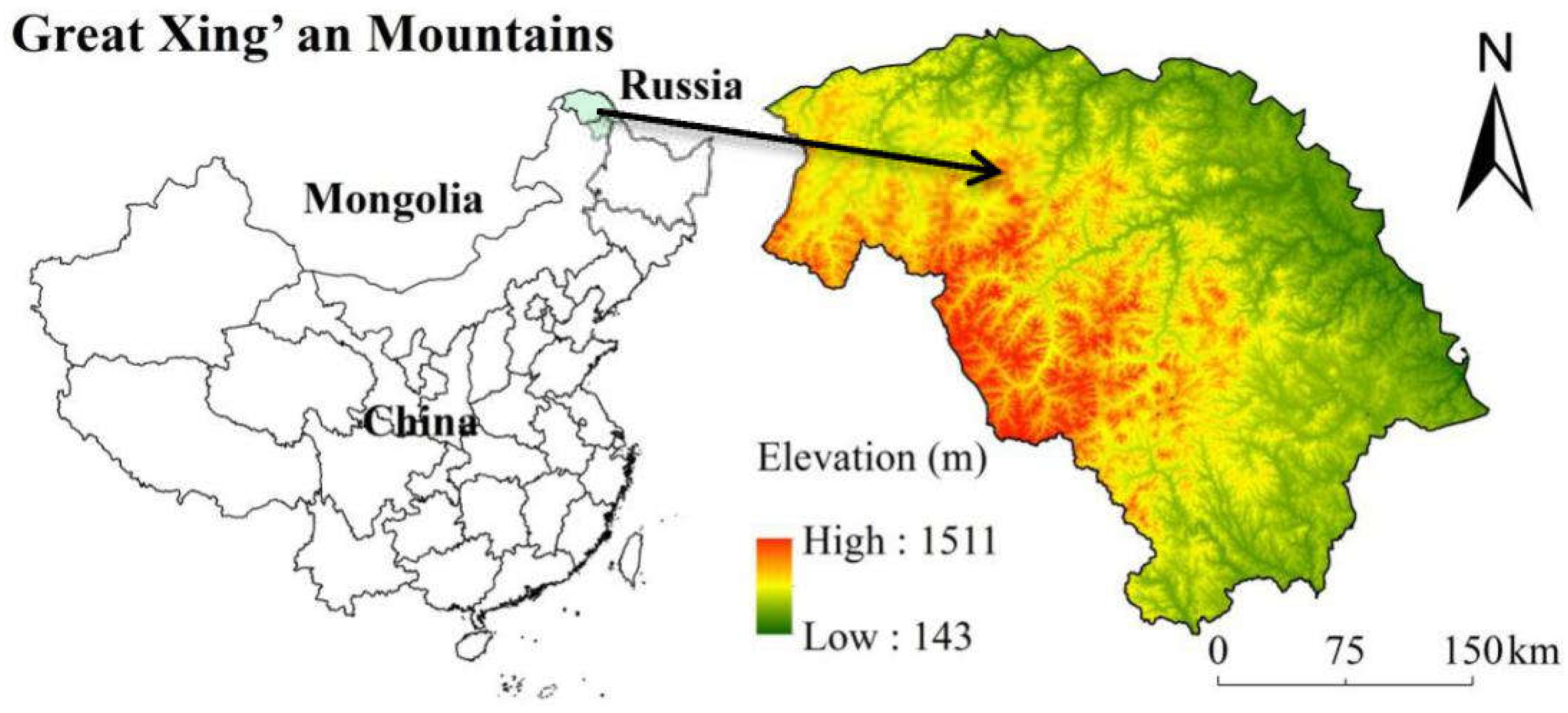
2.1. Study Area
2.2. Study Object
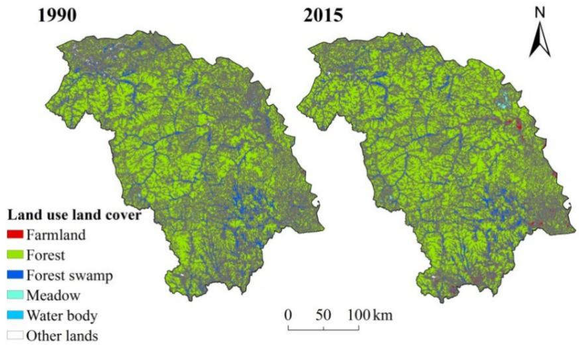
2.3. Land Use Land Cover Datasets
2.4. Environmental Factors Datasets
2.5. Landscape Metrics
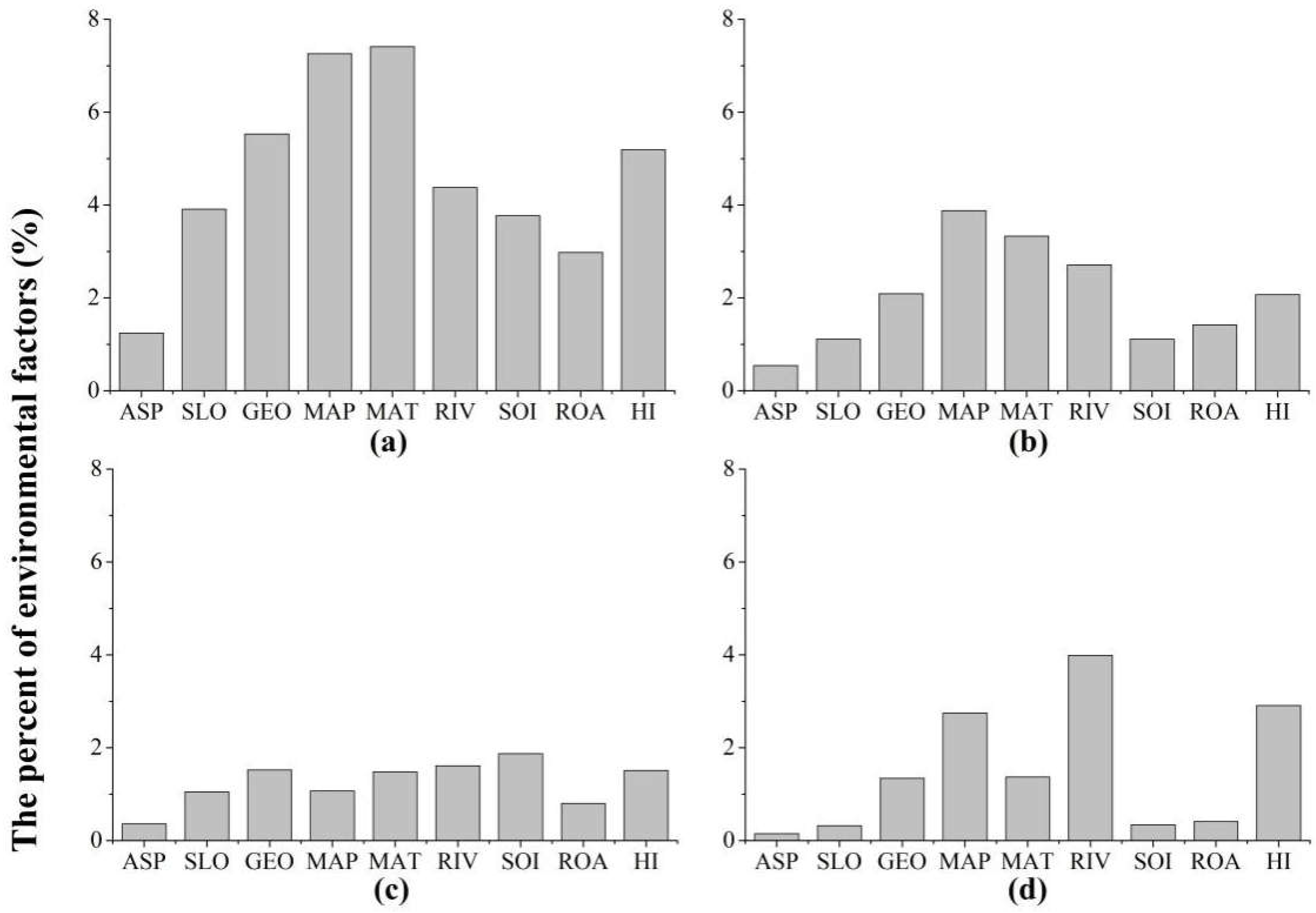
2.6. The Variable Importance
2.7. Data Analysis
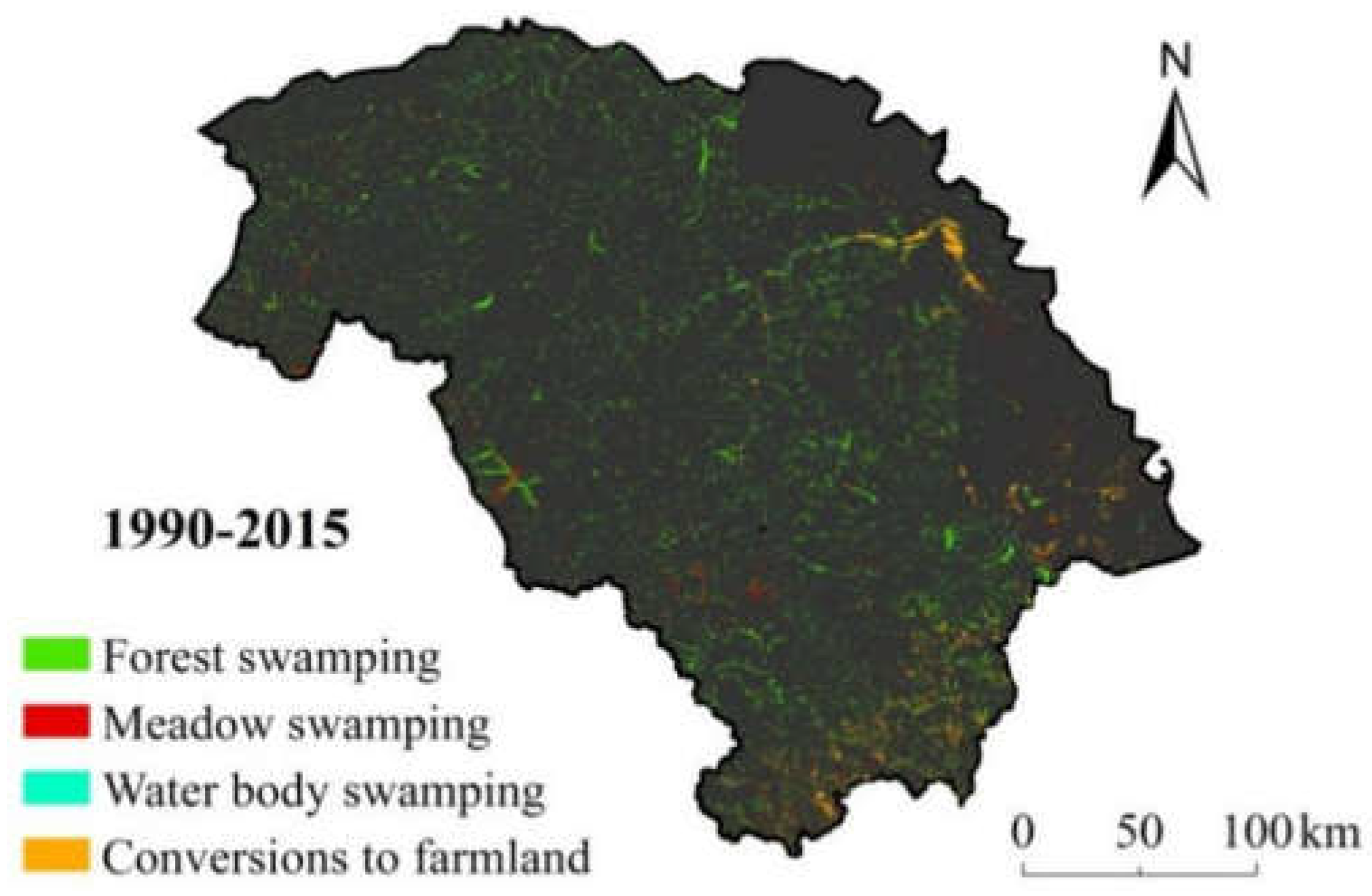
3. Results
4. Discussion
5. Conclusions
Author Contributions
Acknowledgments
Conflicts of Interest
References
- Bian, H.; Yan, T.; Zhang, Z.; He, C.; Sheng, L. Mapping Deciduous Broad-leaved Forested Swamps Using ALOS/Palsar Data. Chin. Geogr. Sci. 2016, 26, 352–365. [Google Scholar] [CrossRef]
- Yan, T. Deciduous Broad-Leaved Forested Wetlands Mapping and its Community Characteristics Analysis in the North Temperate Zone. Master’s Thesis, Northeast Normal University, Changchun, China, 2014. [Google Scholar]
- Manuri, S.; Brack, C.; Nugroho, N.P.; Hergoualc’h, K.; Novita, N.; Dotzauer, H.; Verchot, L.; Putra, C.A.S.; Widyasari, E. Tree biomass equations for tropical peat swamp forest ecosystems in Indonesia. For. Ecol. Manag. 2014, 334, 241–253. [Google Scholar] [CrossRef]
- Moore, S.; Evans, C.D.; Page, S.E.; Garnett, M.H.; Jones, T.G.; Freeman, C.; Hooijer, A.; Wiltshire, A.J.; Limin, S.H.; Gauci, V. Deep instability of deforested tropical peatlands revealed by fluvial organic carbon fluxes. Nature 2013, 493, 660–663. [Google Scholar] [CrossRef] [PubMed] [Green Version]
- Silvius, M.; Schrier, A. Climate Regulation: South East Asian Peat Swamps. In The Wetland Book; Springer: Dordrecht, The Netherlands, 2016. [Google Scholar]
- Nath, T.K.; Dahalan, M.P.B.; Parish, F.; Rengasamy, N. Local Peoples’ Appreciation on and Contribution to Conservation of Peatland Swamp Forests: Experience from Peninsular Malaysia. Wetlands 2017, 37, 1067–1077. [Google Scholar] [CrossRef] [Green Version]
- Lewis, D.B. Response of wetland soil carbon to groundwater conservation: Probabilistic outcomes from error propagation. Ecol. Indic. 2016, 60, 538–547. [Google Scholar] [CrossRef] [Green Version]
- Xu, J.; Wang, H.; Sheng, L.; Liu, X.; Zheng, X. Distribution Characteristics and Risk Assessment of Polycyclic Aromatic Hydrocarbons in the Momoge Wetland, China. Int. J. Environ. Res. Public Health 2017, 14, 85. [Google Scholar] [CrossRef] [PubMed]
- Norhisyam, M.S.; Roshani, O.; Zuhairi, A.N.M.; Akmal, S.N.; Syahril, M.Z.M.; Hawa, S.A.; Wahidah, M.N.; Harmin., A.S. Water Quality, Diversity and Distribution of Blackwater Fishes in Selected Locations of Raja Musa Peat Swamp Forest Reserve. In Proceedings of the Malaysian Sciences and Technology Congress, Kuala Lumpur, Malaysia, 19–21 November 2012. [Google Scholar]
- Shoemaker, W.B.; Anderson, F.; Barr, J.G.; Graham, S.L.; Botkin, D.B. Carbon exchange between the atmosphere and subtropical forested cypress and pine wetlands. Biogeosciences 2015, 12, 2285–2300. [Google Scholar] [CrossRef] [Green Version]
- Du, X.; Zhou, Z.; Zhang, Y.; Zhou, L. Discussion about rules of vegetation’s succession in north of Great Xingan Mountains. Territ. Nat. Resour. Stuty 2002, 2, 33. [Google Scholar]
- Pielech, R.; Malicki, M. Changes in Species Composition in Alder Swamp Forest Following Forest Dieback. Forests 2018, 9, 316. [Google Scholar] [CrossRef]
- Pokorný, P.; Klimešová, J.; Klimeš, L. Late Holocene History and Vegetation Dynamics of a Floodplain Alder Carr: A Case Study from Eastern Bohemia, Czech Republic. Folia Geobot. 2000, 35, 43–58. [Google Scholar] [CrossRef]
- Prentis, P.J.; White, E.M.; Radford, I.J.; Lowe, A.J.; Clarke, A.R. Can hybridization cause local extinction: A case for demographic swamping of the Australian native Senecio pinnatifolius by the invasive Senecio madagascariensis? New Phytol. 2010, 176, 902–912. [Google Scholar] [CrossRef] [PubMed] [Green Version]
- Renard, S.M.; Gauthier, S.; Fenton, N.J.; Lafleur, B.; Bergeron, Y. Prescribed burning after clearcut limits paludification in black spruce boreal forest. For. Ecol. Manag. 2016, 359, 147–155. [Google Scholar] [CrossRef]
- Crawford, R.M.M.; Jeffree, C.E.; Rees, W.G. Paludification and Forest Retreat in Northern Oceanic Environments. Ann. Bot. 2003, 91, 213–226. [Google Scholar] [CrossRef] [PubMed] [Green Version]
- Fang, K.; Gou, X.; Chen, F.; Li, J.; D’Arrigo, R.; Cook, E.; Tao, Y.; Liu, W.; Zhang, F. Tree growth and time-varying climate response along altitudinal transects in central China. Eur. J. For. Res. 2010, 129, 1181–1189. [Google Scholar] [CrossRef]
- Inisheva, L.I.; Turchinovich, I.E. Evolution of the paludification process, and carbon accumulation rate in bog ecosystems of Russia. Geogr. Nat. Resour. 2013, 34, 246–253. [Google Scholar] [CrossRef]
- Partanen, S.; Luoto, M. Environmental determinants of littoral paludification in boreal lakes. Limnologica 2006, 36, 98–109. [Google Scholar] [CrossRef]
- Liu, X.; Lu, R.; Du, J.; Lyu, Z.; Wang, L.; Gao, S.; Wu, Y. Evolution of Peatlands in the Mu Us Desert, Northern China, Since the Last Deglaciation. J. Geophys. Res. Earth Surf. 2018, 123, 252–261. [Google Scholar] [CrossRef]
- Arunachalam, S.; Maharani, K.; Chidambaram, S.; Prasanna, M.V.; Manivel, M.; Thivya, C. A study on the land use pattern change along the coastal region of Nagapattinam, Tamil Nadu. Int. J. Geomat. Geosci. 2011, 1, 700–720. [Google Scholar]
- King, G. Nutritional Condition and Stress Response of Fishes along a Gradient of Habitat Quality in the St. Lawrence River: Physiological Consequences of Anthropogenic Habitat Degradation. Master’s Thesis, University of Illinois at Urbana-Champaign, Urbana, IL, USA, 2014. [Google Scholar]
- Song, K.; Wang, Z.; Li, L.; Tedesco, L.; Li, F.; Jin, C.; Du, J. Wetlands shrinkage, fragmentation and their links to agriculture in the Muleng–Xingkai Plain, China. J. Environ. Manag. 2012, 111, 120–132. [Google Scholar] [CrossRef] [PubMed]
- Simard, M.; Lecomte, N.; Bergeron, Y.; Bernier, P.Y.; Paré, D. Forest productivity decline caused by successional paludification of boreal soils. Ecol. Appl. 2007, 17, 1619–1637. [Google Scholar] [CrossRef] [PubMed]
- Zhao, Y.; Du, L. Research on contributing factor types and the rule of distribution of forestry swamp on the large and lesser Xingan Mountains. J. Northeast For. Univ. 1980, 1980, 27–35. [Google Scholar]
- Yu, B.; Stott, P.; Yu, H.; Li, X. Methane Emissions and Production Potentials of Forest Swamp Wetlands in;the Eastern Great Xing’an Mountains, Northeast China. Environ. Manag. 2013, 52, 1149–1160. [Google Scholar] [CrossRef] [PubMed]
- Hao, G. The Variation of Soil Quality and the Sustainable Utilization of Hilly Dryland in the East of Great Xingan Mountains. Ph.D. Thesis, Chinese Academy of Agricultural Sciences, Beijing, China, 2009. [Google Scholar]
- Ren, B.; Han, F.; Hu, Y.; Chang, Y.; Thiele, J.; Guo, J.; Yan, X.; Gong, J.; Bu, R. Plant community responses to changes in permafrost thaw depth in the Great Hing’an Mountain Valleys, China. Phytocoenologia 2018, 48, 273–281. [Google Scholar] [CrossRef]
- Sun, J.; Li, X.; Wang, X.; Lü, J.; Li, Z. Plant species distribution in permafrost wetlands of the Great Hing’an Mountain valleys and its response to global climate change. J. Earth Sci. 2010, 21, 266–270. [Google Scholar] [CrossRef]
- Sun, J.; Li, X.; Wang, X.; Lü, J.; Li, Z.; Hu, Y. Analysis of structures of permafrost wetland plant communities along environmental gradients in the Da Hinggan Mountains, China. Chin. J. Plant Ecol. 2010, 34, 1165–1173. [Google Scholar]
- Huang, P.; Zhuo, L. Larix gmelinii; Wiley-VCH Verlag GmbH & Co. KGaA: Weinheim, Germany, 2014. [Google Scholar]
- Kitao, M.; Lei, T.T.; Nakamura, T.; Koike, T. Manganese toxicity as indicated by visible foliar symptoms of Japanese white birch (Betula platyphylla var. japonica). Environ. Pollut. 2001, 111, 89–94. [Google Scholar] [CrossRef]
- Baranov, V.I.; Basargin, D.D. Taxonomy of Betula fruticosa Pall. (Betulaceae). Bot. Zh. 1979, 64, 514–525. [Google Scholar]
- Azimova, S.S.; Glushenkova, A.I. Cerasus fruticosa Pall. (Prunus chamaecerasus Jacq. P. fruticosa Pall.); Springer: London, UK, 2012; p. 711. [Google Scholar]
- Gu, D.; Zhang, Q.; Zhu, J. Establishment of plantlet rapid propagation system and in vitro germplasm conservation of Rhododendron parvifolium. J. Northeast For. Univ. 2009, 37, 26–28. [Google Scholar]
- He, X.; Wang, D. Effects of relieving cough and expelling phlegm for domesticated Ledum palustre var. angustum. J. Northeast For. Univ. 2010, 38, 107–108. [Google Scholar]
- Zeng, W.; Li, Y.; Di, L.; Sun, X.; Li, Y. Study on Paclobutrazol Mitigating Effects on Drought Stress of Blueberry (Vaccinium uliginosum Linn.). J. Anhui Agric. Sci. 2012, 40, 8063–8065. [Google Scholar]
- Bartha, D. Salix rosmarinifolia; Wiley-VCH Verlag GmbH & Co. KGaA: Weinheim, Germany, 2014. [Google Scholar]
- Shaver, G.R.; Laundre, J. Exsertion, elongation, and senescence of leaves of Eriophorum vaginatum and Carex bigelowii in Northern Alaska. Glob. Chang. Biol. 2010, 3, 146–157. [Google Scholar] [CrossRef]
- Shorohova, E.; Fedorchuk, V.; Kuznetsova, M.; Shvedova, O. Wind-induced successional changes in pristine boreal Picea abies forest stands: Evidence from long-term permanent plot records. Forestry 2008, 81, 335–359. [Google Scholar] [CrossRef]
- Yan, H.; Liu, R.; Liu, Z.; Wang, X.; Luo, W.; Sheng, L. Growth and Physiological Responses to Water Depths in Carex schmidtii Meinsh. PLoS ONE 2015, 10, e0128176. [Google Scholar] [CrossRef] [PubMed]
- Kyrkjeeide, M.O.; Hassel, K.; Flatberg, K.I.; Shaw, A.J.; Yousefi, N.; Stenøien, H.K. Spatial Genetic Structure of the Abundant and Widespread Peatmoss Sphagnum magellanicum Brid. PLoS ONE 2016, 11, e0148447. [Google Scholar] [CrossRef] [PubMed] [Green Version]
- Kyrkjeeide, M.O.; Hassel, K.; Stenøien, H.K.; Prestø, T.; Boström, E.; Shaw, A.J.; Flatberg, K.I. The dark morph of Sphagnum fuscum (Schimp.) H.Klinggr. in Europe is conspecific with the North American S. beothuk. J. Bryol. 2016, 37, 251–266. [Google Scholar] [CrossRef]
- Teleganova, V.V.; Ignatov, M.S. On the reproductive biology of Ptilium crista-castrensis (Pylaisiaceae, Bryophyta). Arct. J. Bryol. 2007, 16, 87–98. [Google Scholar] [CrossRef]
- Tian, Y.; Luo, L.; Mao, D.; Wang, Z.; Li, L.; Liang, J. Using Landsat images to quantify different human threats to the Shuangtai Estuary Ramsar site, China. Ocean Coast. Manag. 2017, 135, 56–64. [Google Scholar] [CrossRef]
- Prospero, J.M. The Ground-Based Absolute Radiometric Calibration of Landsat 8 OLI. Remote Sens. 2015, 7, 600–626. [Google Scholar] [Green Version]
- Yu, K.; Liu, S.; Zhao, Y. CPBAC: A quick atmospheric correction method using the topographic information. Remote Sens. Environ. 2016, 186, 262–274. [Google Scholar] [CrossRef]
- Ke, Y.; Quackenbush, L.J.; Im, J. Synergistic use of QuickBird multispectral imagery and LIDAR data for object-based forest species classification. Remote Sens. Environ. 2014, 114, 1141–1154. [Google Scholar] [CrossRef]
- Shruthi, R.B.V.; Kerle, N.; Jetten, V. Object-based gully feature extraction using high spatial resolution imagery. Geomorphology 2011, 134, 260–268. [Google Scholar] [CrossRef]
- Myint, S.W.; Giri, C.P.; Wang, L.; Zhu, Z.L.; Gillette, S.C. Identifying mangrove species and their surrounding land use and land cover classes using an object-oriented approach with a lacunarity spatial measure. Mapp. Sci. Remote Sens. 2008, 45, 188–208. [Google Scholar] [CrossRef]
- Jia, M.; Wang, Z.; Li, L.; Song, K.; Ren, C.; Liu, B.; Mao, D. Mapping China’s mangroves based on an object-oriented classification of Landsat imagery. Wetlands 2014, 34, 277–283. [Google Scholar] [CrossRef]
- Li, H.; Man, W.; Li, X.; Ren, C.; Wang, Z.; Li, L.; Jia, M.; Mao, D. Remote sensing investigation of anthropogenic land cover expansion in the low-elevation coastal zone of Liaoning Province, China. Ocean Coast. Manag. 2017, 148, 245–259. [Google Scholar] [CrossRef]
- Dong, Z.; Wang, Z.; Liu, D.; Song, K.; Li, L.; Jia, M.; Ding, Z. Mapping Wetland Areas Using Landsat-Derived NDVI and LSWI: A Case Study of West Songnen Plain, Northeast China. J. Indian Soc. Remote Sens. 2014, 42, 569–576. [Google Scholar] [CrossRef]
- Mao, D.; Wang, Z.; Li, L.; Ma, W. Spatiotemporal dynamics of grassland aboveground net primary productivity and its association with climatic pattern and changes in Northern China. Ecol. Indic. 2014, 41, 40–48. [Google Scholar] [CrossRef]
- Zhang, Q.; Wang, P.; Chen, H.; Huang, Q.; Jiang, H.; Zhang, Z.; Zhang, Y.; Luo, X.; Sun, S. A novel method for urban area extraction from VIIRS DNB and MODIS NDVI data: A case study of Chinese cities. Int. J. Remote Sens. 2017, 38, 6094–6109. [Google Scholar] [CrossRef]
- Mao, D.; Luo, L.; Wang, Z.; Wilson, M.C.; Zeng, Y.; Wu, B.; Wu, J. Conversions between natural wetlands and farmland in China: A multiscale geospatial analysis. Sci. Total Environ. 2018, 634, 550–560. [Google Scholar] [CrossRef] [PubMed]
- Xu, W. The relation between the zonal distribution of types of vegetation and the climate in Northeast China. Acta Phytoecol. Geobot. Sin. 1986, 10, 254–263. [Google Scholar]
- Jia, M.; Liu, M.; Wang, Z.; Mao, D.; Ren, C.; Cui, H. Evaluating the Effectiveness of Conservation on Mangroves: A Remote Sensing-Based Comparison for Two Adjacent Protected Areas in Shenzhen and Hong Kong, China. Remote Sens. 2016, 8, 627. [Google Scholar] [CrossRef]
- Mao, D.; Wang, Z.; Luo, L.; Ren, C.; Jia, M. Monitoring the Evolution of Wetland Ecosystem Pattern in Northeast China from 1990 to 2013 Based on Remote Sensing. J. Nat. Resour. 2016, 31, 1253–1263. [Google Scholar]
- Man, W.; Wang, Z.; Liu, M.; Lu, C.; Jia, M.; Mao, D.; Ren, C. Spatio-temporal dynamics analysis of cropland in Northeast China during 1990–2013 based on remote sensing. Trans. Chin. Soc. Agric. Eng. 2016, 32, 1–10. [Google Scholar]
- Li, S.; Wang, Y.; Lin, C. The characteristics and functions of cold temperate wetland in the Great Xing’an Mountains. In Proceedings of the 7th National Congress of the Chinese Ecological Society, Mianyang, China, 20–24 September 2004. [Google Scholar]
- Sun, G. Swamps formation and evolution. Territ. Nat. Resour. Study 1998, 10, 33–35. [Google Scholar]
- Yang, Y. Study on formation and development of forest swamp and paleoenvironment change since the holocene in the east part of the Xiaoxinganling mountains. Oceanol. Limnol. Sin. 2003, 34, 74–82. [Google Scholar]
- Liu, J.; Dong, C.; Sheng, L.; Liu, Y. Landscape Pattern Change of Marsh and Its Response to Human Disturbance in the Small Sanjiang Plain, 1955–2010. Sci. Geogr. Sin. 2016, 36, 879–887. [Google Scholar]
- Mcgarigal, K.; Marks, B.J. FRAGSTATS: Spatial Analysis Program for Quantifying Landscape Structure; General Technical Report PNW-GTR-351; USDA Forest Service: Washington, DC, USA, 1995.
- Vincenzi, S.; Zucchetta, M.; Franzoi, P.; Pellizzato, M.; Pranovi, F.; Leo, G.A.D.; Torricelli, P. Application of a Random Forest algorithm to predict spatial distribution of the potential yield of Ruditapes philippinarum in the Venice Lagoon, Italy. Ecol. Model. 2011, 222, 1471–1478. [Google Scholar] [CrossRef]
- Breiman, L. Random Forest. Mach. Learn. 2001, 45, 5–32. [Google Scholar] [CrossRef]
- Mellor, A.; Haywood, A.; Stone, C.; Jones, S. The Performance of Random Forests in an Operational Setting for Large Area Sclerophyll Forest Classification. Remote Sens. 2013, 5, 2838–2856. [Google Scholar] [CrossRef] [Green Version]
- Wei, W.; Nie, Y.; Zhang, Z.; Hu, Y.; Yan, L.; Qi, D.; Li, X.; Wei, F. Hunting bamboo: Foraging patch selection and utilization by giant pandas and implications for conservation. Biol. Conserv. 2015, 186, 260–267. [Google Scholar] [CrossRef]
- Hobley, E.; Wilson, B.; Wilkie, A.; Gray, J.; Koen, T. Drivers of soil organic carbon storage and vertical distribution in Eastern Australia. Plant Soil 2015, 390, 111–127. [Google Scholar] [CrossRef]
- Yao, D. Research on Feature Selection and Classification Method Based on Radom Forest for Medical Datasets. Ph.D. Thesis, Harbin Engineering University, Harbin, China, 2015. [Google Scholar]
- Cutler, A.; Cutler, D.R.; Stevens, J.R. Random Forests; Springer: New York, NY, USA, 2012; pp. 157–175. [Google Scholar]
- Cutler, D.R.; Edwards, T.C., Jr.; Beard, K.H.; Cutler, A.; Hess, K.T.; Gibson, J.; Lawler, J.J. Random forests for classification in ecology. Ecology 2007, 88, 2783–2792. [Google Scholar] [CrossRef] [PubMed]
- Calle, M.L.; Urrea, V. Letter to the Editor: Stability of Random Forest importance measures. Brief. Bioinform. 2011, 12, 86–89. [Google Scholar] [CrossRef] [PubMed]
- Hart, S.J.; Veblen, T.T.; Kulakowski, D. Do tree and stand-level attributes determine susceptibility of spruce-fir forests to spruce beetle outbreaks in the early 21st century? For. Ecol. Manag. 2014, 318, 44–53. [Google Scholar] [CrossRef]
- Baguskas, S.A.; Peterson, S.H.; Bookhagen, B.; Still, C.J. Evaluating spatial patterns of drought-induced tree mortality in a coastal California pine forest. For. Ecol. Manag. 2014, 315, 43–53. [Google Scholar] [CrossRef]
- Wei, Y.; Li, J.; Qing, J.; Huang, M.; Wu, M.; Gao, F.; Li, D.; Hong, Z.; Kong, L.; Huang, W. Discovery of Novel Hepatitis C Virus NS5B Polymerase Inhibitors by Combining Random Forest, Multiple e-Pharmacophore Modeling and Docking. PLoS ONE 2016, 11, e0148181. [Google Scholar] [CrossRef] [PubMed]
- Zhao, D.; He, H.; Wang, W.; Wang, L.; Du, H.; Liu, K.; Zong, S. Predicting Wetland Distribution Changes under Climate Change and Human Activities in a Mid- and High-Latitude Region. Sustainability 2018, 10, 863. [Google Scholar] [CrossRef]
- Lu, D.; Mausel, P.; Brondízio, E.; Moran, E. Change detection techniques. Int. J. Remote Sens. 2004, 25, 2365–2401. [Google Scholar] [CrossRef]
- Modica, G.; Praticò, S.; Fazio, S.D. Abandonment of Traditional Terraced Landscape: A Change Detection Approach (A Case Study in Costa Viola—Calabria, Italy). Land Degrad. Dev. 2017, 28, 2608–2622. [Google Scholar] [CrossRef]
- Foody, G.M. Status of land cover classification accuracy assessment. Remote Sens. Environ. 2002, 80, 185–201. [Google Scholar] [CrossRef]
- Hu, L.; Fan, W.; Ren, H.; Liu, S.; Cui, Y.; Zhao, P. Spatiotemporal Dynamics in Vegetation GPP over the Great Khingan Mountains Using GLASS Products from 1982 to 2015. Remote Sens. 2018, 10, 488. [Google Scholar] [CrossRef]
- Liu, H.; Bu, R.; Liu, J.; Leng, W.; Hu, Y.; Yang, L.; Liu, H. Predicting the wetland distributions under climate warming in the Great Xing’an Mountains, northeastern China. Ecol. Res. 2011, 26, 605–613. [Google Scholar] [CrossRef]
- Li, X.; Pang, H.; Zhao, Y.; Sun, M.; Zhang, X.; Xu, N.; He, G.; Zhang, H.; Sun, G. Shifts in the bacterial community structure and function along a vegetation gradient in the Great Xing’an Mountains. Scand. J. For. Res. 2017, 33, 103–113. [Google Scholar] [CrossRef]
- Keith, D.A.; Rodoreda, S.; Bedward, M. Decadal change in wetland-woodland boundaries during the late 20th century reflects climatic trends. Glob. Chang. Biol. 2010, 16, 2300–2306. [Google Scholar] [CrossRef]
- Simard, M.; Bernier, P.Y.; Bergeron, Y.; Paré, D.; Guérine, L. Paludification dynamics in the boreal forest of the James Bay Lowlands: Effect of time since fire and topography. Can. J. For. Res. 2008, 39, 546–552. [Google Scholar] [CrossRef]
- Aisien, S.O.; Salami, L.A.; Obaro, F.E.; Erakpoweri, S.O. The influence of climate on the distribution of monogeneans of anurans in Nigeria. J. Helminthol. 2004, 78, 101–104. [Google Scholar] [CrossRef] [PubMed]
- Todorova, M.; Grozeva, N.; Dermendgieva, D. Soil properties and salt content of soil from Inland salt meadow near Radnevo town. Agrric. Sci. Technol. 2014, 6, 68–71. [Google Scholar]
- Douda, J.; Čejková, A.; Douda, K.; Kochánková, J. Development of alder carr after the abandonment of wet grasslands during the last 70 years. Ann. For. Sci. 2009, 66, 712. [Google Scholar] [CrossRef]
- Zhou, R.; Lang, H.; Ma, K.; Yang, G. The formation, succession, develpoment, and utilization of Greater Khingan Mountains swamps. Territ. Nat. Resour. Study 1990, 1990, 38–42. [Google Scholar]
- Zhou, Y.; Zhou, L. The main meteorological factors of formation and development of mire meadow of Qinghai Lake drainage area. Chin. Geogr. Sci. 1998, 8, 232–238. [Google Scholar] [CrossRef]
- Payette, S. Late-Holocene Development of Subarctic Ombrotrophic Peatlands: Allogenic and Autogenic Succession. Ecology 1988, 69, 516–531. [Google Scholar] [CrossRef]
- Negassa, W.C.; Guber, A.K.; Kravchenko, A.N.; Marsh, T.L.; Hildebrandt, B.; Rivers, M.L. Properties of Soil Pore Space Regulate Pathways of Plant Residue Decomposition and Community Structure of Associated Bacteria. PLoS ONE 2015, 10, e0123999. [Google Scholar] [CrossRef] [PubMed]
- Klimova, N.V.; Chernova, N.A.; Pologova, N.N. Plant component features of forest-bog ecotones of eutrophic paludification in the south of boreal forest zone of West Siberia. IOP Conf. Ser. Earth Environ.Sci. 2018, 138, 012007. [Google Scholar] [CrossRef]
- Zhou, Z.; Liu, T.; Zhou, L. Natural Mongolian Pine Forests in the Great Xing’an Mountains, Northeast China. For. Ecosyst. 2003, 5, 1–5. [Google Scholar]
- Borg, H.; Johansson, K. Metal fluxes to Swedis forest lakes. Water Air Soil Pollut. 1989, 47, 427–440. [Google Scholar] [CrossRef]
- Santos, R.M.B.; Fernandes, L.F.S.; Moura, J.P.; Pereira, M.G.; Pacheco, F.A.L.; Santos, R.M.B.; Moura, J.P. The impact of climate change, human interference, scale and modeling uncertainties on the estimation of aquifer properties and river flow components. J. Hydrol. 2014, 519, 1297–1314. [Google Scholar] [CrossRef]
- Song, K.; Liu, D.; Wang, Z.; Zhang, B.; Jin, C.; Li, F.; Liu, H. Land Use Change in Sanjiang Plain and Its Driving Forces Analysis since 1954. Acta Geogr. Sin. 2008, 63, 93–104. [Google Scholar]
- Wang, Z.; Song, K.; Liu, D.; Zhang, B.; Zhang, S.; Li, F.; Ren, C.; Jin, C.; Yang, T.; Zhang, C. Process of land conversion from Marsh into Cropland in the sanjiang plain during 1954–2005. Wetl. Sci. 2009, 7, 208–217. [Google Scholar]
- Haverstock, M.; Madani, A.; Baldé, H.; Vanderzaag, A.; Gordon, R. Performance of an Agricultural Wetland-Reservoir-Irrigation Management System. Water 2017, 9, 472. [Google Scholar] [CrossRef]
- Lu, H.; Du, P.; Chen, Y.; He, L. A credibility-based chance-constrained optimization model for integrated agricultural and water resources management: A case study in South Central China. J. Hydrol. 2016, 537, 408–418. [Google Scholar] [CrossRef]
- Wang, Z.; Wu, J.; Madden, M.; Mao, D. China’s Wetlands: Conservation plans and policy impacts. Ambio 2012, 41, 782–786. [Google Scholar] [CrossRef] [PubMed]
- Abdurachman, A. [Utilization of ex PLG swamp land in Central Kalimantan (Indonesia) for agricultural development which related to environmental insight]. J. Penelit. Pengemb. Pertan. 2000, 19, 77–81. [Google Scholar]
- Heimlich, R.E.; Langner, L.L. Swampbusting, Wetland Conversion and Farm Programs; US Department of Agriculture, Economic Research Service: Washington, DC, USA, 1986.


| Forest Swamp Conversions | NP | PD (n/100 ha) | ED (%) | PARA_MN | AI (%) |
|---|---|---|---|---|---|
| Forest swamping | 34,916 | 8.51 | 3.30 | 313.41 | 56.66 |
| Meadow swamping | 3,613 | 0.88 | 2.29 | 306.26 | 58.75 |
| Water body swamping | 3,791 | 0.92 | 0.74 | 348.32 | 27.46 |
| Conversion to farmland | 4,795 | 1.17 | 0.77 | 289.91 | 67.82 |
| Factor | Variable | Abbr. | Unit | Characterizations |
|---|---|---|---|---|
| Topographic | Beer’s aspect | ASP | 0.06–2 | |
| Topographic | Slope | SLO | ° | 1.51–42.69 |
| Geomorphic | Geomorphic type | GEO | Mainly includes middle-altitude and medium relief mountains, low-altitude and medium relief mountains, low-altitude and small relief mountains, and low-altitude alluvial plain, alluvial floodplain, and hills. | |
| Climatic | Mean annual precipitation | MAP | mm | 374.64–466.71 |
| Climatic | Mean annual temperature | MAT | °C | −4.17–−0.45 |
| Hydrologic | Distance to rivers | RIV | km | The first-order stream and the second-order stream of the study area are selected to make buffers at intervals of 12 km according to the extent of study area. |
| Edaphic | Soil type | SOI | Mainly includes swampy soil, skeleton soil, meadow soil, dark brown soil, and brown coniferous forest soil. | |
| Human | Distance to roads | ROA | km | Uses the road map to make buffers at intervals of 3 km according to the extent of study area. |
| Human | Human interference degree | HI | 0.02–73.55 |
© 2018 by the authors. Licensee MDPI, Basel, Switzerland. This article is an open access article distributed under the terms and conditions of the Creative Commons Attribution (CC BY) license (http://creativecommons.org/licenses/by/4.0/).
Share and Cite
Zhao, D.; He, H.S.; Wang, W.J.; Liu, J.; Du, H.; Wu, M.; Tan, X. Distribution and Driving Factors of Forest Swamp Conversions in a Cold Temperate Region. Int. J. Environ. Res. Public Health 2018, 15, 2103. https://doi.org/10.3390/ijerph15102103
Zhao D, He HS, Wang WJ, Liu J, Du H, Wu M, Tan X. Distribution and Driving Factors of Forest Swamp Conversions in a Cold Temperate Region. International Journal of Environmental Research and Public Health. 2018; 15(10):2103. https://doi.org/10.3390/ijerph15102103
Chicago/Turabian StyleZhao, Dandan, Hong S. He, Wen J. Wang, Jiping Liu, Haibo Du, Miaomiao Wu, and Xinyuan Tan. 2018. "Distribution and Driving Factors of Forest Swamp Conversions in a Cold Temperate Region" International Journal of Environmental Research and Public Health 15, no. 10: 2103. https://doi.org/10.3390/ijerph15102103