Article

A Hydrogeologic Framework for Understanding Surface Water and Groundwater Interactions in a Watershed System in the Willamette Basin in Western Oregon, USA

1
Ecohydrology Lab, College of Agricultural Sciences, Oregon State University, Corvallis, OR 97331, USA
2
Institute for Water and Watersheds, Oregon State University, Corvallis, OR 97331, USA
3
Water Resources Graduate Program, Oregon State University, Corvallis, OR 97331, USA
*
Author to whom correspondence should be addressed.
Geosciences 2022, 12(3), 109; https://doi.org/10.3390/geosciences12030109
Submission received: 31 January 2022 / Revised: 22 February 2022 / Accepted: 22 February 2022 / Published: 25 February 2022
(This article belongs to the Section Hydrogeology)

Abstract

:
A broad understanding of local geology and hydrologic processes is important for effective water resources management. The objectives of this project were to characterize the hydrogeologic framework of the Oak Creek Watershed (OCW) geographical area and examine the connections between surface water and groundwater at selected locations along the main stem of Oak Creek. The OCW area comprises the Siletz River Volcanic (SRV) Formation in the upper portion of the watershed and sedimentary rock formations in the valley. Past hydrologic and geologic studies and our field measurement data were synthesized to create a hydrogeologic framework of the watershed, including a geologic interpretation and a conceptual model of shallow, deep, and lateral groundwater flow throughout the OCW. The highly permeable geology of the SRV formation juxtaposed against the Willamette Basin’s sedimentary geology creates areas of opposing groundwater flow characteristics (e.g., hydraulic conductivity) in the watershed. The Corvallis Fault is the primary interface between these two zones and generally acts as a hydraulic barrier, deflecting groundwater flow just upstream of the fault interface. The extreme angle of the Corvallis Fault and adjacent less permeable sedimentary geology might facilitate subsurface bulk water storage in selected locations. The stream-aquifer relationships investigated showed gaining conditions are prominent in the upper watershed’s northern volcanic region and transition into neutral and losing conditions in the downstream southern sedimentary region in the valley. Agriculture irrigation seepage in the valley appeared to contribute to streamflow gaining conditions. Results from this case study contribute critical information toward enhancing understanding of local hydrogeologic features and potential for improved SW-GW resources management in areas near coastal ranges such as those found in the Pacific Northwest, USA.

1. Introduction

Understanding the interactions between surface water and groundwater (SW-GW) is critical for improved water resources management [1,2]. Surface water and groundwater cannot be seen as isolated components [3] and the role of geology in their spatial and temporal variability throughout the landscape needs to be better understood. The replenishment of groundwater from surface water sources such as irrigation and precipitation can be influenced by geologic characteristics, such as the presence of fractured bedrock or basalt [4], and the timing and quantity of precipitation [5,6] or irrigation [7,8]. A common expression of SW-GW relationships occurs at the stream and aquifer intersection. Geology has long been considered a primary driver of watershed hydraulic characteristics [9,10,11] such as streambed permeability and the rate of surface water infiltration into the aquifer [12]. A variable SW-GW flow exchange can influence the streamflow volume between any two points along the stream and can create gaining conditions where groundwater inputs contribute to streamflow, or losing conditions where streamflow is lost through the permeable substrate [13,14,15]. Groundwater inputs can constitute a significant portion of the overall streamflow volume of a gaining reach or stream, especially during low-flow conditions [16]. The SW-GW connections are highly dependent on the geological features responsible for water transport and distribution throughout the landscape [4,17,18,19].
Geologic faults are another feature that significantly influences SW-GW relationships, particularly the dynamics of groundwater flow. Faulting impacts groundwater hydrology by altering flow vectors near the fault core zone [20]. Fault gouge, coupled with separation, creates a broad spectrum of hydraulic barriers, conduits, or a combination of these [4,17,20,21]. Impermeable areas within fault zones can sever the hydraulic continuity of aquifers, producing incongruent groundwater tables and isolated groundwater compartments. Active faults can have irregular fault core thickness and a degree of damage to surrounding rock along their profile length [21]. Varying degrees of damage and fault gouge create significant contrasts in permeability along with the fault profile, and as a result, a single fault can be both a barrier and a conduit for groundwater flow [21,22].
A common resource management integration of SW-GW relationships is by using groundwater replenishment tools such as managed aquifer recharge (MAR). In a 60-year retrospective of global MAR, Dillon et al. [23] indicated that “MAR is a management tool to consider with and complement new efficiency measures in irrigation, switching to low water use crops, conjunctive use of surface water and groundwater resources including substituting use of recycled water for groundwater, and foregoing extraction”. The drivers for considering MAR in various forms include limited surface reservoir sites, increased costs associated with surface water treatment for harmful algal blooms, decreasing barriers to fish passage, and increased costs to purchase water from regional water suppliers. Over the past 50 years, the storage of managed aquifer recharge in the US has increased nearly 10-fold from approximately 300 Mm3 year−1 in 1965 to 2570 Mm3 year−1 in 2015 [23].
According to the Oregon Water Resources Department (OWRD), managed recharge and related aquifer storage and recovery (ASR) projects have been operating in Oregon since 1996, with more than 7.5 Mm3 per year stored annually. Potential aquifer storage identified by Woody [24] approaches Oregon’s annual public water supply in the year 2000, or 500 Mm3. Oregon currently has approximately 15 state-authorized and planned ASR test sites servicing municipalities and agriculture. Most of these sites store water in volcanic rock aquifers, including the Siletz River Volcanics [24]. The use of small-scale managed recharge utilizing rainwater or spring water for domestic well storage is increasingly considered in mountainous areas underlain by low permeability volcanic rocks and siltstone [25,26]. Likewise, a market for aquifer storage space is gaining momentum as the concept of Aquifer Recharge Units (ARU) is being developed [27].
Characterizing hydrogeology’s role in SW-GW interactions is critical for understanding the potential for integrated water resources management, including stream-aquifer interactions and groundwater recharge. This project examined hydrogeological features influencing SW-GW interactions in the southern portion of the Willamette Basin region in western Oregon, USA. The objectives of this case study were to: (1) characterize the hydrogeological framework of the watershed geographical area, and (2) examine stream-aquifer relationships along the main stem of the creek.

2. Materials and Methods

2.1. Study Site

The study was conducted in the Oak Creek Watershed (OCW) within the Willamette Basin region. The OCW (44.57° latitude; −123.30° longitude) encompasses 3360 hectares, and it is adjacent (west) to the City of Corvallis, Oregon, USA. The main stem of Oak Creek flows 11 km from its source and highest point (650 m above sea level, MASL) in the McDonald-Dunn Forest to its lowest point (64 MASL) at the confluence with Marys River. The climate in the region is a Mediterranean type, with a warm and dry season in the summer and a mild and wet winter season. Most precipitation occurs as rainfall between November and April. Mean annual precipitation within the basin ranges from 2500 mm at higher elevations to 1000 mm at lower elevations [28]. The monthly-averaged lowest temperature occurs in January (0.67 °C), while the highest occurs in August (27.4 °C). The lowest and highest total monthly precipitation occurring in July (9.1 mm) and December (181.4 mm), respectively [29]. Oak Creek is a fourth-order headwater stream with discharge volumes generally ranging between 0.01 m³ s−1 and 0.25 m³ s−1, and peak discharge reaching up to 6 m³ s−1 in the winter. Upland overstory vegetation at the OCW is dominated by Douglas-Fir (Pseudotsuga menziesii), western hemlock (Tsuga heterophylla), and western red cedar (Thuja plicata). At lower elevation sites, White oak (Quercus alba), red alder (Alnus rubra), Oregon ash (Fraxinus latifolia), and bigleaf maple (Acer macrophyllum) dominate the landscape.
Land cover in OCW encompasses forest (70%), agriculture (12%), urban (12%), and undeveloped (6%). Land use categories at OCW include forestry in the uplands, agriculture in mid to lower elevation sites, and urban including Oregon State University (OSU)’s main campus at the bottom of the watershed. Much of the area of the OCW is a mixture of publicly and privately-owned forest maintained for uses such as timber harvest, protected water drinking water-supply source areas, recreation, and forestry and agricultural research stations associated with the Colleges of Agricultural Sciences and College of Forestry at OSU. Approximately 20 hectares of OSU’s pasture fields in the lower valley are irrigated with water diverted from Oak Creek during the summer. Water pumped from the creek is run through underground pipes that feed individual irrigation lines with multiple sprinkler pods at different fields. The rest of the agricultural activity in OCW depends mostly on the soil moisture accumulated during the wet precipitation season in the winter. No deep groundwater extraction for agriculture irrigation currently exists at the OCW. The Siletz River Volcanic (SRV) rock formation underlying much of OCW has become increasingly important for municipal and domestic water supplies in the last 30 years [30]. Over the past 20 years, significant residential growth near the cities of Corvallis and Philomath, Oregon, USA has been occurring [30,31].
The generalized hydrostratigraphy of the rocks underlying OCW has been summarized by [20,30,32,33] based on water well logs available from the OWRD, oil exploration wells available from the Oregon Department of Geology and Mineral Industries (ODGMI), field examination of rock quarries, outcrop examination, and hydrogeologic mapping (Table 1).

2.2. Hydrogeologic Framework

2.2.1. Site Geologic Conditions Map and Hydrogeologic Cross-Sections

Information from several sources including previous geophysical research conducted in the OCW [20], oil and gas exploration well logs maintained by the ODGMI, United Stated Geologic Survey (USGS) geological maps, OWRD water well logs, and our field-based data were used to create a Site Geologic Conditions Map along with cross-sections of site geologic and hydrogeologic conditions (Figure 1).
Well logs of particular interest included those of a 655 m deep well completed in 1934 by the Willamette Petroleum Syndicate (WPS) located in south Corvallis near the outlet of the watershed (see Figure 1), and a 2581 m deep well completed in 1964 by the Gulf Oil Corporation of California (GOC) located approximately 18 km to the southeast near Halsey, Oregon, USA (location not shown on Figure 1). The GOC well penetrates surficial alluvial deposits of soil, clay, sand, and gravel before encountering the Eugene Formation, the Spencer Formation, the Yamhill Formation, the Tyee Formation, and finally, the SRV Formation at 2160 m below ground surface. The WPS well records are relatively complete to a depth of 655 m, other than a missing section between 412 and 475 m depth, which was likely omitted due to a high-pressure water flow event occurring when the borehole was deepened with a cable tool. The well log annotation substantiated that the drillers required a water shut-off valve when they reached approximately 450 m. This interval is likely a confined aquifer and is stratigraphically located in a volcano-clastic conglomerate mentioned in the GOC well log. If the missing zone and the volcano-clastic zone are stratigraphically equivalent, this zone’s apparent thickness likely decreases from nearly 450 to 60 m thick from east to west.
Seismic reflection data and deep exploratory well logs throughout the Willamette Valley reveal the bottom SRV unit extends from beneath the continental shelf in the west [34,35] to as far east as the Cascade Range [20]. Geophysical evidence shows the thickness of the SRV formation to be approximately 8 to 18 km [36,37,38], with about 4.5 km exposed west of the Corvallis Fault [20].
The Corvallis Fault, which bisects the watershed, is a low-angle reverse-thrust fault [20] uplifting the watershed’s northern volcanic region over the southern sedimentary region and pushing it to the southwest. The position of the fault creates two distinct geologic areas with opposing hydrogeologic conditions. Portions of the study site north of the Corvallis Fault overlie the SRV Formation, which consists of a mélange of permeable Paleocene to Eocene submarine basaltic pillow lavas interbedded with less permeable tuffaceous marine sediments which dip approximately 20 degrees to the west. The fault-cutting alignment perpendicular across the watershed creates an abrupt interface between the northern high conductivity volcanic geology and the southern low conductivity sedimentary geology. Additionally, numerous dikes of gabbro, diorite, and aplite rock cut through the fault zone and act as hydraulic barriers, completely severing the hydraulic connection at the fault interface and redirecting groundwater in these areas [20]. The low angle of the Corvallis Fault creates a wedge of Siletz Formation volcanic rocks overlying Spencer and Tyee formation sedimentary rocks [20] which compartmentalizes vertical groundwater movement and promotes horizontal groundwater movement parallel to the fault line.
South of the Corvallis Fault, geology abruptly transitions into thick repetitious sequences of bedded units of graded sandstones, siltstones, and shales [39]. Fractured marine basalt found north of the Corvallis Fault interface is highly permeable due to large conduits (fractures) cutting through the formation; however, the rock itself is nearly nonporous. Conversely, the sedimentary formations found south of the fault are more porous but less permeable.
These two regions’ opposing hydrological characteristics influence where and how groundwater flows and how late into the dry summer season water remains in these formations to supply surface water streams (baseflow). The Tyee and Spencer formations, sandstones and siltstones with high porosity (14% to 49%) but low permeability ( 1 × 10 11   to   6 × 10 6   m   s 1 ), can sustain baseflow into surface water streams later into the dry season when compared to the less porous (3% to 35%) and more permeable ( 4 × 10 7   to   2 × 10 2   m   s 1 ) basalts of the SRV Formation [40,41].
To better understand the geologic structure of the OCW, we constructed two hydrogeologic cross-sections (A-A’ and B-B’), the locations of which are shown on the surface geology map (see Figure 1). Cross-section A-A’ runs from the McDonald-Dunn Forest in the northern region of the watershed in a southeast direction through Oak Creek and the Corvallis Fault. Cross-section B-B’ runs from west to east, approximately perpendicular to Oak Creek at the OSU Sheep Center.
Subsurface geology and static water level information represented on the geologic cross-sections were obtained through the analysis of over 600 OWRD well logs, two deep exploration drill logs (WPS and GOC), geology maps, previous research reports [20,30,32,42], and our stream and shallow groundwater well level information. Geologic and hydrologic data of wells within 250 m of each side of the cross-section line were projected onto the cross-section transect to create a vertical hydrogeologic profile (n = 620). Additionally, well log stratigraphy from the nearby WPS and GOC deep exploration wells were projected to the cross-section profile (n = 2). Together, the cross-sections provide a three-dimensional representation of the hydrogeologic framework of the OCW site and an indication of how the Corvallis Fault affects OCW groundwater dynamics.

2.2.2. Stream-Aquifer Interactions

We used shallow groundwater and stream levels data to assess stream-aquifer interactions at one site (OSU Sheep Center; 118 MASL) in the northern volcanic portion of the watershed and one site (OSU Dairy Center; 80 MASL) in the southern basin-sediment infills. Data from previously installed monitoring wells (<6 m depth; 50 mm diameter) were used to characterize water table fluctuations at these two sites [33]. Two wells (sw-1 and sw-2) were in the riparian area at the OSU Sheep Center, and three wells (dw-1 to dw-3) were located in the riparian zone at the OSU Dairy Center. A laser level was used to measure onsite soil surface, stream, and water table elevation to develop cross-section profiles at each location. Data from two other wells in a 2-ha irrigated pasture grass field and one well in its adjacent riparian area, near the stream gauge, were used to characterize irrigation percolation contributions to the shallow aquifer and potential return flow to the stream. All wells were equipped with water level loggers (Model HOBO U20-001-01, Onset Computer, Corp., Bourne, MA, USA) and programmed to record data every hour. A water level meter (Model 101, Solinist Canada Ltd., Georgetown, ON, Canada) was used to collect depth to water table during selected dates. These data were used for verification or calibration of the water level loggers. A water level logger (Model HOBO MX2001, Onset Computer, Corp., Bourne, MA, USA) was installed in each location (OSU Sheep Center and OSU Dairy Center) to measure stream water level fluctuations.
In addition to the monitoring of stream and groundwater levels to assess stream-aquifer interactions, we also monitored hydrostatic pressure differential at selected locations in the streambed during summer groundwater baseflow conditions. We built a hydraulic potentiometric manometer (potentiomanometer) [33] to collect hydrostatic pressure data from 20 different locations along the creek, from its headwaters to its mid and lower reaches. Three measurements at each location were taken at 1 m depth in areas where streambed conditions permitted an adequate seal between the potentiomanometer and surrounding sediment. Locations with large rocks, highly compacted sediments, or sand and gravel bottoms did not provide adequate conditions for manometer readings. A ‘vertical gradient’ (positive or negative) was obtained for each location based on the potentiomanometer readings. Hydrostatic pressure values of zero or between −1 and 1 mm were considered to be neutral [33].

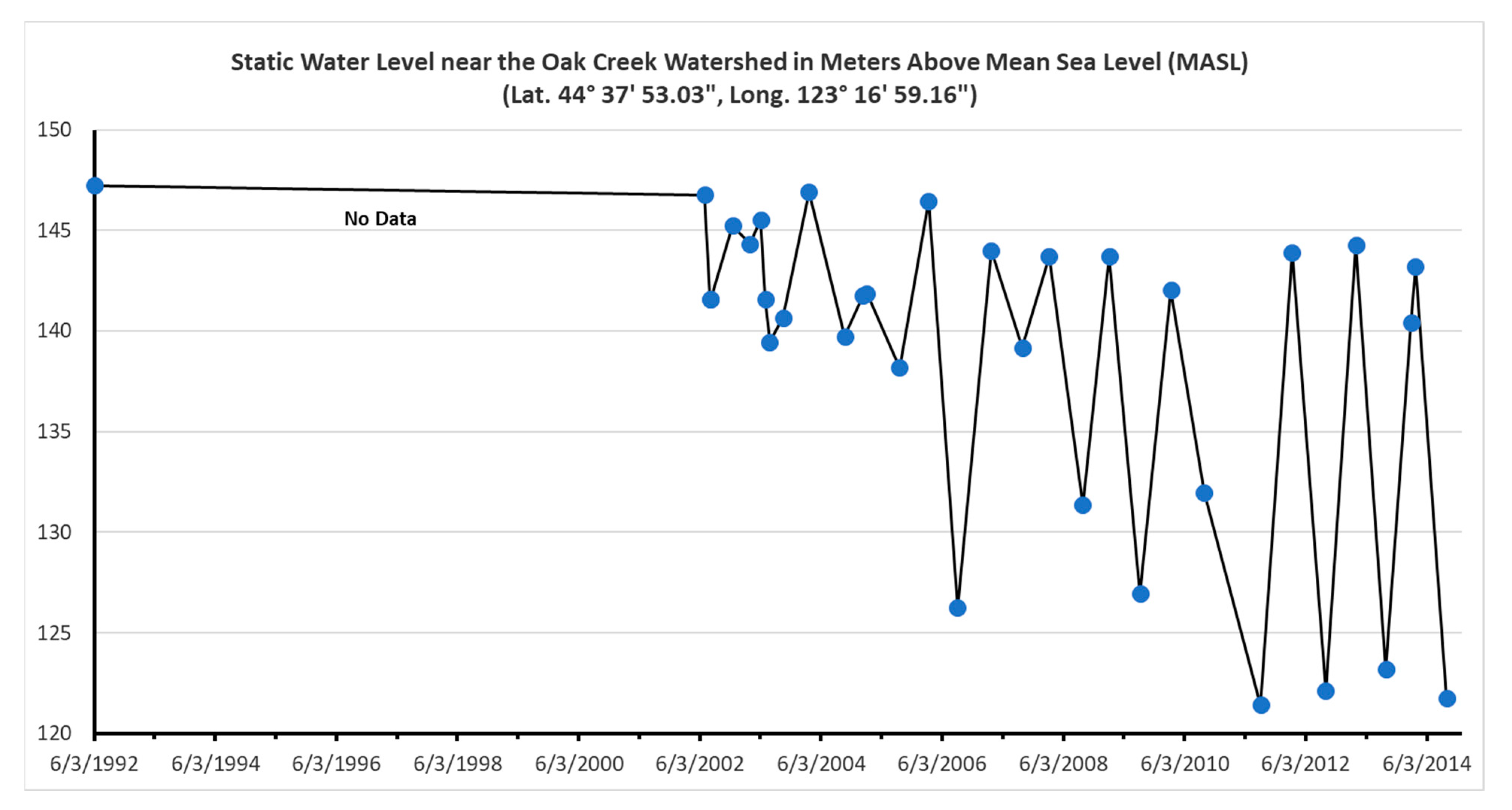
2.2.3. Potentiometric Surface Map

We developed a potentiometric surface map based on a previous study on springs and losing reaches of the upper watershed [30], static water level data obtained from OWRD well logs, surface water levels of surrounding rivers and streams, and data obtained from our observation wells. Potentiometric contour lines were created by first generating an Excel® spreadsheet detailing the position of wells, surface water observation locations, and the respective static water level of our observation wells at each location. Static water level (meters below ground surface) was then subtracted from the ground surface elevation to obtain hydrostatic head in meters at each location. The OWRD water level measurements span approximately 65 years and at different times of the year, as summarized in their well-log database. We acknowledge there could be much uncertainty; consequently, all the wells’ data are referenced as a generalized summary of water level measurements. Long-term data from observation wells at or near OCW are scarce. Data from a well near the OCW showed seasonal static water level variations of about 4 to 25 m during the period or record 1994 to 2014 (Figure A1). This is within the contour interval of 25 m we used in generating the potentiometric surface map.
Given static water levels in individual wells represent a snapshot in time, synoptic contour lines were generated using the spatial analyst extension of ArcMap® (Version: 10.4.1, ESRI, Redland, CA, USA) to create a digital elevation model (DEM) of the water table surrounding the OCW. Spatial analyst does not consider the influence of the Corvallis Fault when using water elevation data to generate the DEM. Thus, specific contour lines were manually edited to show the elevation of groundwater more accurately as it crosses the geologic interface at the Corvallis Fault. These maps were compared to and shown to be consistent with past hydrologic research in the area (see for example [32]).
Potential lines were edited where there were conflicting or limited data. For example, the potential lines were not shown in areas with a limited potentiometric low associated with pumping from clusters of domestic wells. Likewise, the potential lines were adjusted where our field observations of the potentiomanometer readings suggested gaining or losing reaches that conflicted with direct field observations such as a spring occurrence or detailed water level measurements in dedicated observation wells.

3. Results

3.1. Hydrogeologic Framework

3.1.1. Hydrogeologic Cross-Sections

Figure 2a,b shows the cross-sectional representation of the three distinct geologic formations found at the OCW study site: the fractured and highly permeable SRV Formation to the north of the Corvallis Fault, the low permeability Tyee and Spencer Formations to the south of the fault, and the fault zone itself. The water table in the sedimentary basin region is laterally continuous compared to stratigraphically compartmentalized water-bearing zones found in the Siletz Formation [30]. Depths to water in the OCW site ranged from nearly ground-surface (<1 to 3 m) in the upper region of the watershed near the McDonald-Dunn Forest to nearly 100 m below ground surface in the central portion of the watershed near the OSU Sheep Center (see Figure 1).
Figure 2a (cross-section A-A’) shows the multilayered aquifer system of the SRV formation, as well as the shallow and deep aquifer zones of the basin region east of the fault. Data from the WPS and GOC deep exploration wells showed that the water table in the basin east of the fault was generally within 3 to 5 m below the ground surface, with slight fluctuation throughout the year. The GOC drill logs showed a 400+ m thick layer of a water-bearing zone of volcano-clastic conglomerate extending as far west as the Corvallis Fault. Dip estimations suggest the volcano-clastic layer shallows to the west from the GOC well and could be located 10 to 60 m below the OSU Horse Center (Figure 2a). Previous field observations by Goldfinger [20] near the City of Philomath, OR, noted this volcano-clastic layer outcropping in a gravel pit within Spencer Formation siltstones on the Corvallis Fault interface. The volcano-clastic layer at the Philomath Gravel Pit supports the notion that this layer is contiguous east to the GOC exploration well location, dipping between 1 and 3 degrees to the north striking to the southwest.
Figure 2b (cross-section B-B’) illustrates the Siletz River Volcanics region of the watershed. Data from nearby well logs showed unconfined, confined, perched, and compartmentalized aquifer systems within the SRV formation near the OSU Sheep Farm. Depth to water table data was more erratic as the distance from Oak Creek increased, with static water levels adjacent to the creek found near the ground surface. Static water levels decreased in elevation as the distance from the creek increased. Additionally, artesian wells near the west end of the profile (data not shown) indicated confined aquifers within the SRVs near the OSU Sheep Center and McDonald-Dunn Forest. During the dry season, the central water-bearing unit in this region appeared to be individual isolated pockets of sandstone within the SRVs.

3.1.2. Stream-Aquifer Relationships

Figure 3 shows three years (2019–2021) of seasonal water level fluctuations in the stream, the monitoring well in the riparian zone, and a well in a non-irrigated crop field at the OSU Dairy Center, in the sedimentary rock formations (see Figure 1). The well in the riparian area is 6 m north of the stream, the well in the irrigated field is 160 m north of the stream, and the well in the non-irrigated agricultural field is 90 m south of the stream. Relatively rapid rises and declines in stream level in response to rainfall events during winter and spring were observed. Groundwater levels in all wells began rising with the onset of winter precipitation, which reached its peak in January. Following the end of the rain season in the spring, groundwater levels started a steady decline, which in the non-irrigated field continued until baseflow conditions were reached in the fall. In the irrigated field, groundwater levels started rising soon after the onset of the irrigation season (July to September) and remained relatively high during the summer and fall. A slight groundwater level rise during the irrigation season was also observed in the riparian area well, located 6 m north of Oak Creek and 40 m south of the irrigated field’s edge. Marginal to no summer precipitation was observed during the three years evaluated; therefore, the groundwater level rises observed in the wells in the irrigated field and riparian area were attributed to irrigation seepage and return flow to the stream, respectively. All irrigation applications were from water diverted from Oak Creek. Total water applied (irrigation depth) for the pasture field depicted in Figure 3 was 510 mm in 2020 and 670 mm in 2021. No records are available for 2019. Annual total precipitation was 871, 1004, and 1043 mm in 2019, 2020, and 2021, respectively.
A closer look at stream and groundwater levels variability in the wells in irrigated, non-irrigated, and riparian areas during the 2020 irrigation season (27 July to 12 September) is shown in Figure 4. A downward groundwater level trend, typical of the transition to baseflow conditions in the summer, can be observed in all wells before the start of irrigation. While a steady decline in groundwater level occurred in the non-irrigated field during the rest of the season, the well in the irrigated field first, followed by the well in the riparian area, showed a rise in groundwater level of up to 1.18 m a few days after irrigation started. Several peak and slow decline events observed in the irrigated field well corresponded to irrigation applications. Groundwater levels for both the riparian and irrigated field wells continued higher than the non-irrigated field during the remainder of the irrigation season.
Variable seasonal stream-aquifer interactions along non-irrigated fields in both the SRV and Sediments formations were observed. Figure 5a shows groundwater and Oak Creek levels at an upstream cross-section at the OSU Sheep Center, in the SRV rocks-dominated area of the OCW in 2021 (See Figure 1). The steep gradient between groundwater and stream levels for peak flow in the winter and baseflow in the summer indicated ‘gaining’ streamflow conditions. Figure 5b shows groundwater and Oak Creek levels at a downstream cross-section at the OSU Dairy Center, in the Sediments portion of the OCW. At this reach, groundwater and stream levels showed ‘losing’ streamflow conditions during the summer (baseflow) and ‘gaining conditions’ during the winter precipitation season.
Data from the potentiomanometer test conducted under baseflow conditions in the summer showed that the Oak Creek streambed is losing water to the aquifer at locations upstream from the confluence with Alder Creek (see Figure 1), in the permeable fractured volcanic geology, as indicated by the negative pressure values obtained. The negative vertical hydraulic gradient gradually decreased until it reversed at approximately 3 km upstream of the Corvallis Fault, where multiple readings showed a positive slope immediately upstream of the fault. Once Oak Creek crossed the Corvallis Fault, hydraulic gradients became much less variable and maintained neutral or positive pressure conditions, as reported in [33].

3.1.3. Potentiometric Surface Map

The potentiometric surface map (Figure 6) generated from shallow static water level and surface water level data showed that the region’s water table generally followed surface topography across the study area. Most of the groundwater within the OCW originated in higher elevations in the McDonald-Dunn Forest and flowed down-gradient to the south towards Oak Creek and Marys River’s confluence. Water table elevation levels are 1 to 3 m higher on the northern side of the fault line and then drop significantly immediately past the fault. Once past the fault plane, water table elevations and gradients had much less variance than those of the volcanic region. In the southern region, surface topography affected water table elevations in places, but groundwater generally flows at a consistent gradient toward either the Marys River or the Willamette River.
The watershed’s northern volcanic portion was characterized by downward vertical gradients that flowed from several aquicludes and aquitards, resulting in a multilayered aquifer system (see Figure 2a: Cross-Section A-A’). Water table levels in the southern sedimentary region of the watershed generally remained much more consistent, only fluctuating between 1 to 5 m throughout the year.
The Corvallis Fault lies at the boundary between the Siletz Formation and the Tyee and Spencer Formations and acts as the interface between these two opposing hydrologic zones. Potentiometric contour lines generated from OWRD well log data indicated that the fault zone acts as both a barrier and a conduit for groundwater flow through the fault interface. Impermeable zones within the fault deflect groundwater, while large fractures and truncations allow groundwater to pass. Additionally, the abrupt change in permeability between the two formations impacts groundwater paths and velocities, as fluid transfer through geologic material is much more efficient in the watershed’s northern volcanic region.
Hydraulic gradients within the OCW generally mimic the topography, with groundwater circulating from higher elevations towards lower elevations in the creek channel or to the south in the basin. This is generally true down to the Corvallis Fault, where the fault’s impermeable nature causes groundwater to flow parallel to the fault plane until it either finds a conduit or flows through the terminus of the fault damage zone.
Potentiometric contour lines adjacent to the fault have been altered by the change in permeability architectures and the less-permeable fault zone, which has caused them to become fragmented in places. Additionally, water table elevations in the Oak Creek basin within 1 to 2 km northwest of the fault-line have been elevated, as indicated by the area’s diminutive groundwater flow gradient.

3.1.4. Conceptual Model

A conceptual (block) model, including the neighboring hydrogeologic conditions, was created to gain a three-dimensional representation of the OCW and surrounding region’s hydrogeologic framework. The model developed is a synthesis of available topographic, geologic, and hydrologic data. Location, depth, and representation of geologic formations and structures were based on geologic descriptions from well logs and maps described by Goldfinger [20]. The nearby WPS and GOC deep exploration wells drilled southeast of the OCW provided data on subsurface geology structure, including lithology, potential water-bearing zones, dip and strike of geological layers, and water quality. The dip angle and distance from the exploration wells to the study area were considered when interpreting hydrogeological structure and conditions.
The Oak Creek Watershed conceptual model (Figure 7) shows that watershed hydrologic characteristics are dominated by surface topography and geology. The highly contrasting permeability architecture of the opposing geologic formations and the fault between the northern volcanic and the southern sedimentary regions influence groundwater flow through the fault interface. This groundwater compartmentalization model is consistent with other studies completed in fractured volcanic aquifers in Oregon [4,43]. Past drilling and other research data [20,30] in the OCW have indicated numerous intrusions of very low permeability volcanics throughout the region, especially along faults. The contrasting permeabilities of the northern and southern regions paired with impermeable intrusives along the fault interface have produced a zone of decreased permeability along the fault plane. As groundwater circulates hydraulically down-gradient and encounters this zone, velocities decrease, and flow is deflected along the fault strike. Groundwater gradients within the two regions of the study site are highly contrasting, with higher grades in the northern volcanic region compared to a lower grade in the southern sedimentary region. The fracture permeability, coupled with the higher surface slope in the Siletz Formation, results in a discontinuous water table with numerous perched and confined systems. In contrast, low permeability, and low gradients in the Tyee and Spencer formations of the southern region create a shallow water table circulating towards the Willamette River, which serves as a regional hydraulic sink (Figure 7).

4. Discussion

4.1. Interaction of Geology and Hydrology

Previous sections discussed the geology and hydrology using a synthesis approach building upon rather than duplicating previous studies. Most of the physical hydrology studies summarized in this study focused on low flow conditions, given this is a time of year with competition for water use between agricultural facilities, fisheries, and rural residential land use rather than exploring the interaction of geology, direct runoff, and baseflow. Seasonal SW-GW connections are variable and can be contrasting within short distances. Gaining conditions are prominent in the watershed’s northern volcanic region and transition into neutral and losing conditions in the southern sedimentary region. As depicted in Figure 8, the upper part of the watershed is a springs basin where the SRV is composed of low permeability rock mixed with higher permeability breccia and interflow zones, similar to conditions commonly found in rock quarries. Based on areal analysis, the rocks and interflow zones dip westward due to uplift along the Corvallis Fault. Losing reaches of the incised streams are more common where the topography becomes less steep. Whether the noted stream losses can be directly attributed to a function of changes in permeability architecture is uncertain and its study goes beyond the purpose of this synthesis paper.
The middle section of the watershed constitutes a generally gaining reach of the mainstem of Oak Creek. Drainage from the overlying perched aquifer to springs discharging along the stream bank can be observed downgradient of the OSU animal research facilities. Ground-truthing through observations of water levels in shallow wells confirmed the hydraulic separation of the perched aquifer from the deeper volcanic rock aquifer. Stable isotope analyses of stream water, coupled with general water chemistry analyses, indicate mixing of surface water and groundwater in the OCW exists [44]. Reconnaissance-level stream gauging using a potentiomanometer identified isolated losing reaches [33]. Whether the losing reaches are a function of an apparent increase in intercalated low permeability sedimentary rocks or volcanic rock permeability architecture or stream capture of clusters of permit-exempt wells servicing the rural residences remains unknown without further investigations.
Study results showed that the hydrogeology of the OCW is characterized by two regions of contrasting hydrologic properties: the highly fractured and permeable Siltez Volcanic rocks in the northern region of the watershed and the low permeability sediments of the Spencer, Yamhill, and Tyee formations in the southern region. The interface between these two regions is the Corvallis Fault that serves as a hydraulic barrier to groundwater flowing downgradient from the Coastal Range to the Marys River basin to the south and the Willamette River to the east. The Corvallis Fault severs the hydraulic continuity of the volcanic rock aquifer by juxtaposing the lower permeability sedimentary rocks to the east against the higher permeability rocks on the hanging wall of the reverse fault. The hydrologic barrier interpretation of the Corvallis Fault is corroborated by previous work that mapped the Benton County area’s well function, including wells located within the OCW and SRV, Tyee, and Spencer Formations. Transmissivity, specific capacity, and total yield all increased in the Oak Creek Basin area near the Corvallis Fault [30]. These findings are consistent with the hydrogeologic framework presented in this article. As groundwater encounters the less-permeable interface of the Corvallis Fault, it backs up, increasing the amount of groundwater available for withdrawal. This results in groundwater mounding in the SRV north of the fault that contributes to the compartmentalization of the volcanic rock aquifer.
Higher variability of groundwater level exists within the Siletz Formation compared to the Tyee and Spencer formations. The potentiometric surface map developed in this study provides evidence of the northern and southern regions’ opposing permeability architectures and hydraulic conductivities. Water contours in the northern region generally have a higher gradient than those in the southern region due to the volcanic rock’s greater effective porosity (permeability) and hydraulic conductivity. Water moves more freely through the northern portion of the watershed, and as a result, the hydraulic gradient is steeper in the northern region compared to the southern region. The potentiometric surface map developed in this project is consistent with a groundwater map completed in the Corvallis area that stopped just east of the OCW [32]. While no wells penetrate the Corvallis Fault to confirm the hydraulic separation from west to east, the decrease in hydraulic gradient in wells tapping the sedimentary rocks to the east, coupled with the reported artesian flow from a nearby oil and gas exploration well provides first order approximations of the lack of direct hydraulic continuity across the Corvallis Fault. Irrigation of fields along the lower reach of the OCW also complicate the confident assessment of gaining and losing reaches as some of the return flows from irrigation occur along the north bank of the stream. Yet, water levels measured in shallow wells located on the south bank of the stream are unchanged during the irrigation season.

4.2. Groundwater Compartmentalization

The Corvallis Fault, coupled with complex inter-layering of sedimentary rocks and volcanic rocks and groundwater mounding, has created a groundwater compartment in the OCW. Groundwater compartments have demonstrated the suitability of Columbia River Basalts for the storage of water and gas. Mansfield [45] described a compartmentalized aquifer in northwestern Oregon for aquifer storage and recovery as an affordable alternative to above-ground storage. The Mist Gas Field, located along the Oregon coast near Astoria, Oregon, has been used since the 1980s to store natural gas in compartmentalized volcanic rocks similar to the compartment described by Mansfield, precluding the need for expensive above-ground storage facilities [46]. Harpham [43] designed an Aquifer Storage and Recovery project to repurpose a dam site in the Deschutes Basin near Tumalo, Oregon, USA where a surface water reservoir constructed on the footwall of a fault in the volcanic rocks has never held water since construction in 1915. Ringrose and Meckel [47] cite the role of fault architecture as a critical element for storage site characterization elsewhere in the world, citing a global petroleum assessment where 71% of the known hydrocarbon reserves occurred in structural (i.e., faulted) traps, as opposed to stratigraphic or other traps.
Beyond the trace of the Corvallis Fault, the outline of the OCW groundwater compartment closely coincides with watershed boundary. As depicted in Figure 6, the northern boundary is defined hydraulically by the groundwater mounding or “divide” just beyond the watershed boundary. Likewise, the aquifer compartment’s southern boundary closely coincides with the watershed boundary, which is hydraulically defined by groundwater mounding or divide.

4.3. Land and Watershed Management Practices

An isotope and geochemical investigation by Johnson [44] identified a connection between agricultural land use in the middle reaches of the OCW. The preponderance of forest and agricultural use within the OCW, coupled with the related rural residences served by individual permit-exempt water wells, underscores the importance of protecting drinking water supplies, especially given that permit-exempt water wells are typically paired with onsite wastewater systems that are well known for contributing nitrates and phosphorus to groundwater [48]. While the Agricultural Improvement Act (Farm Bill) of 2018 primarily focuses on building partnerships between water utilities and agricultural producers in watersheds to limit nutrient and sediment runoff, the Conservation Partnership Programs rarely address groundwater and much less groundwater supplying drinking water derived from private wells [49].
This paradox is not unique to the Farm Bill of 2018. The Wellhead Protection and Source Water Protection Programs associated with the Safe Drinking Water Act, as amended in 1986, served as the impetus behind states to develop programs to protect groundwater supplying public water systems. However, the Wellhead Protection and Source Water Protection Programs continued to overlook protection for areas serviced by private wells. The Sole Source Aquifer program authorized by the Safe Drinking Water Act of 1974 allowed citizens to petition the Environmental Protection Agency for Sole Source Aquifer Designation when an aquifer supplies at least 50% of the drinking water for a “service area” and if there are no reasonably available alternative drinking water sources should the aquifer become contaminated. This study provides an example of the type of information needed to develop a Source Water Protection program in mixed agriculture, forestry, and rural residential land use through the Sole Source Aquifer petition process.

4.4. Framework Adds to Role of Geology and Potential Groundwater Supplies

One of the ancillary goals of the study was to evaluate the substitution for surface water supplies used by research farms that require temporary dams on Oak Creek which inhibit fish passage. The OCW study offers an unusual alignment of supplemental water needs, hydrogeologic framework that contributes to water supply options, current favorable land use for water quality protection, and aquifer compartmentalization for subsurface storage. The nearby communities of Philomath and Dallas, Oregon, USA are experiencing growth and desire to develop new groundwater supplies and underground water storage options in the same aquifers underlying the OCW. The findings of our study contribute options to supplement these and other local municipal water supplies [50] and can inform proposed aquifer storage and recovery (ASR) projects in the surrounding region. ASR is a proven technology used by many municipalities where water is injected and stored in subsurface aquifers for future extraction. Use of ASR may be possible within the volcanic rocks underlying the OSU agricultural research facilities. Comparable hydrogeologic compartmentalization of the volcanic rocks in the OCW were proven to be instrumental in ASR in the volcanic rocks underlying Warren, Oregon, USA as described by Mansfield [44].
While proximity does not guarantee viability, the OCW is located near other ASR projects utilizing the volcanic rocks for subsurface storage. Aquifer storage and recovery techniques have been shown to be successful within the volcanic rocks serving as water supplies for the City of Dallas, Oregon, USA. The Dallas ASR system is unique in Oregon because the naturally brackish groundwater found in the volcanic rocks mixes with the injected water. However, recovery of injected water has been sufficient to supplement municipal water supplies during periods of water scarcity.
The neighboring City of Philomath is also pursuing ASR for supplementing municipal drinking water supplies and has generated plans to develop two existing drinking water wells. Philomath water managers expect the ASR project to reduce water demands on the nearby Marys River, which has experienced record low flows during the summer months. Preliminary pump tests and other performance analyses conducted on the City’s wells have shown promising results.
The minimal overburden overlying the SRV in the OCW contribute to the viability of managed recharge. Likewise, constructed wetlands could be used to treat water before infiltration. The general lack of land development, except for small agricultural research facilities, research forest, and the few rural residences, make the OCW a valuable location for managed aquifer recharge.
Hydrogeological information in the OCW region is limited as deep drilling in the area has been sparse. The 650-m deep oil exploration well drilled east of the OCW encountered a sufficient water flow that well casing was installed to shut off the flow. The old well records do not report whether the water was fresh or saline, or any estimated flow rates. However, the available deep well data from nearby oil and gas exploration wells suggests that a well approaching 500 m in depth located east of the Corvallis Fault may encounter fine-grained sandstones capable of yielding sufficient water quantities to facilities located in the lower portion of the OCW, though the produced water quality remains unknown. Further investigation, including the drilling of a small diameter test hole followed by geophysical logging, would provide information on the number and thickness of the interbedded sandstones encountered in the test hole. Geophysical logging would also provide a first-order approximation of the salinity of water stored in the sandstones.

5. Conclusions

This case study contributes critical information toward enhancing understanding of local hydrogeologic features and improved groundwater resources management in areas near coastal ranges such as those found in the Pacific Northwest, USA. While this study’s goal was to characterize the hydrogeologic framework within and near the Oak Creek Watershed (OCW) and enhance base knowledge of groundwater flow and aquifer fluid dynamics in the region, we were able to link this information for current and future water uses. First, the interaction of geology and hydrology are assessed with particular focus on the hydrologic role of the Corvallis Fault. The hydraulic barrier-conduit role of the fault contributes to the compartmentalization of the volcanic rock aquifer, creating two hydraulically separated groundwater compartments. The complex intrinsic and secondary permeability architecture of the volcanic rock aquifers imposed through flows and later structural geologic history link two adjacent watersheds through inter-basin groundwater flow. These findings provide an opportunity for proactive land and watershed management practices given the OCW and nearby mountainous regions are used, or are anticipated to be used, for residential and municipal drinking water supplies, either through direct capture through wells or secondary capture through managed aquifer recharge storage and recovery. Deep drilling frontiers for underutilized groundwater and aquifer storage exist, as shown by the limited hydrogeologic data reported for a smattering of past oil and gas exploration wells near the OCW.

Author Contributions

C.G.O., W.T.J. and J.H. developed the study design. J.H. conducted field data collection. All co-authors contributed to data analyses and the writing of the manuscript. All authors have read and agreed to the published version of the manuscript.

Funding

This research received no external funding.

Institutional Review Board Statement

Not applicable.

Informed Consent Statement

Not applicable.

Acknowledgments

The authors gratefully acknowledge the various graduate and undergraduate students from Oregon State University who helped with field data collection activities related to the results presented here. Also, thanks to Derek Godwin and Mary Santelmann (OSU) for their invaluable support to this research. The study was supported by the Oregon Agricultural Experiment Station.

Conflicts of Interest

The authors declare no conflict of interest.

Appendix A

Figure A1. Example of Static Water Level Measurements at Observation Well near the Oak Creek Watershed (OCW), Corvallis, Orgon, USA. Data source (https://www.oregon.gov/owrd (accessed on 30 January 2022)).
Geosciences 12 00109 g0a1

References

  1. Barlow, P.M.; Leake, S.A. Streamflow Depletion by Wells: Understanding and Managing the Effects of Groundwater Pumping on Streamflow; Geological Survey: Reston, VA, USA, 2012.
  2. Taylor, R.G.; Scanlon, B.; Döll, P.; Rodell, M.; van Beek, R.; Wada, Y.; Longuevergne, L.; Leblanc, M.; Famiglietti, J.S.; Edmunds, M.; et al. Ground Water and Climate Change. Nat. Clim. Change 2013, 3, 322–329. [Google Scholar] [CrossRef] [Green Version]
  3. Sophocleous, M. Interactions between Groundwater and Surface Water: The State of the Science. Hydrogeol. J. 2002, 10, 52–67. [Google Scholar] [CrossRef]
  4. Caruso, P.; Ochoa, C.G.; Jarvis, W.T.; Deboodt, T. A Hydrogeologic Framework for Understanding Local Groundwater Flow Dynamics in the Southeast Deschutes Basin, Oregon, USA. Geosciences 2019, 9, 57. [Google Scholar] [CrossRef] [Green Version]
  5. Seyfried, M.S.; Schwinning, S.; Walvoord, M.A.; Pockman, W.T.; Newman, B.D.; Jackson, R.B.; Phillips, F.M. Ecohydrological Control of Deep Drainage in Arid and Semiarid Regions. Ecology 2005, 86, 277–287. [Google Scholar] [CrossRef]
  6. Durfee, N.; Ochoa, C.G. The Seasonal Water Balance of Western-Juniper-Dominated and Big-Sagebrush-Dominated Watersheds. Hydrology 2021, 8, 156. [Google Scholar] [CrossRef]
  7. Scanlon, B.R.; Faunt, C.C.; Longuevergne, L.; Reedy, R.C.; Alley, W.M.; McGuire, V.L.; McMahon, P.B. Groundwater Depletion and Sustainability of Irrigation in the US High Plains and Central Valley. Proc. Natl. Acad. Sci. USA 2012, 109, 9320–9325. [Google Scholar] [CrossRef] [Green Version]
  8. Ochoa, C.G.; Fernald, A.G.; Guldan, S.J.; Tidwell, V.C.; Shukla, M.K. Shallow Aquifer Recharge from Irrigation in a Semiarid Agricultural Valley in New Mexico. J. Hydrol. Eng. 2013, 18, 1219–1230. [Google Scholar] [CrossRef]
  9. Wolbert, H. Effect Of Subsurface Geology On The Water Quality Of Springs At The Raystown Field Station. J. Ecol. Res. 2002, 4, 63–68. [Google Scholar]
  10. Menichino, G.T.; Hester, E.T. Hydraulic and Thermal Effects of In-Stream Structure-Induced Hyporheic Exchange across a Range of Hydraulic Conductivities. Water Resour. Res. 2014, 50, 4643–4661. [Google Scholar] [CrossRef]
  11. Price, K. Effects of Watershed Topography, Soils, Land Use, and Climate on Baseflow Hydrology in Humid Regions: A Review. Prog. Phys. Geogr. Earth Environ. 2011, 35, 465–492. [Google Scholar] [CrossRef]
  12. Calver, A. Riverbed Permeabilities: Information from Pooled Data. Groundwater 2001, 39, 546–553. [Google Scholar] [CrossRef]
  13. Winter, T.C.; Harvey, J.W.; Frank, O.L.; Alley, W.M. Ground Water and Surface Water: A Single Resource; U.S. Geological Survey: Denver, CO, USA, 1998.
  14. Barthel, R.; Banzhaf, S. Groundwater and Surface Water Interaction at the Regional-Scale—A Review with Focus on Regional Integrated Models. Water Resour. Manag. 2016, 30, 1–32. [Google Scholar] [CrossRef] [Green Version]
  15. Li, Y.; Zhang, Q.; Lu, J.; Yao, J.; Tan, Z. Assessing Surface Water–Groundwater Interactions in a Complex River-Floodplain Wetland-Isolated Lake System. River Res. Appl. 2019, 35, 25–36. [Google Scholar] [CrossRef] [Green Version]
  16. Nickolas, L.B.; Segura, C.; Brooks, J.R. The Influence of Lithology on Surface Water Sources. Hydrol. Process. 2017, 31, 1913–1925. [Google Scholar] [CrossRef]
  17. Ochoa, C.; Caruso, P.; Ray, G.; Deboodt, T.; Jarvis, W.; Guldan, S. Ecohydrologic Connections in Semiarid Watershed Systems of Central Oregon USA. Water 2018, 10, 181. [Google Scholar] [CrossRef] [Green Version]
  18. Savoca, M.; Welch, W.; Johnson, K.; Lane, R.C.; Clothier, B.; Fasser, E. Hydrologic Framework, Groundwater Movement, and Water Budget in the Chambers-Clover Creek Watershed and Vicinity, Pierce County, Washington; USGS: Washinton, DC, USA, 2010.
  19. Welch, W.; Johnson, K.; Savoca, M.; Lane, R.C.; Fasser, E.; Gendaszek, A. Hydrogeologic Framework, Groundwater Movement, and Water Budget in the Puyallup River Watershed and Vicinity, Pierce and King Counties, Washington; U.S. Geological Survey: Washinton, DC, USA, 2015.
  20. Goldfinger, C. Evolution of the Corvallis Fault and Implications for the Oregon Coast Range. Master’s Thesis, Oregon State University, Corvallis, OR, USA, 1990. [Google Scholar]
  21. Anderson, E.I.; Bakker, M. Groundwater Flow through Anisotropic Fault Zones in Multiaquifer Systems. Water Resour. Res. 2008, 44, W11433. [Google Scholar] [CrossRef]
  22. Caine, J.; Evans, J.; Forster, B.C. Fault Zone Architecture and Permeability Structure. Geology 1996, 24, 1025–1028. [Google Scholar] [CrossRef]
  23. Dillon, P.; Stuyfzand, P.; Grischek, T.; Lluria, M.; Pyne, D.; Jain, R.; Bear, J.; Schwarz, J.; Weiping, W.; Escalante, E.; et al. Sixty Years of Global Progress in Managed Aquifer Recharge. Hydrogeol. J. 2018, 27, 1–30. [Google Scholar] [CrossRef] [Green Version]
  24. Woody, J.L. A Preliminary Assessment of Hydrogeologic Suitability for Aquifer Storage AndRecovery (ASR) in Oregon. Master’s Thesis, Oregon State University, Corvallis, OR, USA, 2007. [Google Scholar]
  25. Embleton, D.G. Use of Exempt Wells As Natural Underground Storage and Recovery Systems. J. Contemp. Water Res. Educ. 2012, 148, 44–54. [Google Scholar] [CrossRef]
  26. Robinson, J.; Jarvis, T.; Tullos, D. Domestic Well Aquifer Storage and Recovery Using Seasonal Springs. Water Resour. IMPACT 2017, 19, 22–23. [Google Scholar]
  27. Tuthill, D.R., Jr.; Carlson, R.D. Incentivized Managed Aquifer Recharge Basin Scale Implementation Provides Water for Private Users, Groundwater Districts, Municipalities and Others. Water Rep. 2018, 176, 11–20. [Google Scholar]
  28. Mattson, K.; Runyon, J.; Fernald, S.; Gallagher, A.; Johnson, R.; Snyder, K.; Eden, S.; Zybach, R. Marys River Watershed: Preliminary Assessment; Marys River Watershed Council: Philomath, OR, USA, 1999; p. 146. [Google Scholar]
  29. Oregon State University, Corvallis, Oregon, USA—Climate Summary. Available online: https://wrcc.dri.edu/cgi-bin/cliMAIN.pl?or1862 (accessed on 30 January 2022).
  30. Miles, E.S. A GIS study of Benton County, Oregon, Groundwater: Spatial Distributions of Selected Hydrogeologic Parameters. Master’s Thesis, Oregon State University, Corvallis, OR, USA, 2011. [Google Scholar]
  31. Benton County Staff. Benton County TMDL Water Quality Implementation Plan; Benton County Soil and Water Conservation District: Benton County, OR, USA, 2008.
  32. Frank, F.J. Ground Water in the Corvallis-Albany Area, Central Willamette Valley, Oregon; U.S. Geological Survey: Washinton, DC, USA, 1974; p. 55.
  33. Hall, J. Hydrogeologic Framework and Surface Water-Groundwater Temperature Relations of the Oak Creek Watershed, Western Oregon, USA. Master’s Thesis, Oregon State University, Corvallis, OR, USA, 2020. [Google Scholar]
  34. Snavely, P.D., Jr. Tertiary Geologic Framework, Neotectonics, and Petroleum Potential of the Oregon-Washington Continental Margin. In Geology and Resource Potential of the Continental Margin of Western North America and Adjacent Ocean Basins—Beaufort Sea to Baja California; Circum-Pacific Council for Energy and Mineral Resources. Earth Science Series; Scholl, D.W., Grantz, A., Vedder, J.G., Eds.; Springer: Washington, DC, USA, 1987; pp. 305–335. [Google Scholar]
  35. Snavely, P.D.; Wagner, H.C. Geophysical Data Collected on the Southern Washington Continental Shelf along Line 12, USGS R/V S.P. Lee Cruise 3-76; Open-File Report 82-424; US Geological Survey: Palo Alto, CA, USA, 1982.
  36. Couch, R.W.; Braman, D.E.; Newton, V.C. Geology of the Continental Margin near Florence, Oregon; Oregon Department of Geology and Mineral Industries Oil and Gas Inv.: Portland, OR, USA, 1980; Volume 6, pp. 16–22. [Google Scholar]
  37. Dehlinger, P.; Couch, R.W.; Gemperle, M. Continental and Oceanic Structure from the Oregon Coast Westward across the Juan de Fuca Ridge. Can. J. Earth Sci. 1968, 5, 1079–1090. [Google Scholar] [CrossRef]
  38. Keach, R.W.I.; Oliver, J.E.; Brown, L.D.; Kaufman, S. Cenozoic Active Margin and Shallow Shale Cascades Structure: COCORP Results from Western Oregon. (Consortium for Continental Reflection Profiling). Geol. Soc. Am. Bull. 1989, 101, 1520–1542. [Google Scholar] [CrossRef]
  39. Snavely, P.D.; Wagner, H.C.; MacLeod, N.S. Rhythmic-Bedded Eugeosynclinal Deposits of the Tyee Formation, Oregon Coast Range. Bull. Kans. Geol. Surv. 1966, 169, 461–480. [Google Scholar]
  40. Morris, D.A.; Johnson, A.I. Summary of Hydrologic and Physical Properties of Rock and Soil Materials, as Analyzed by the Hydrologic Laboratory of the U.S. Geological Survey, 1948–1960; Water Supply Paper; U.S. Government Printing Office: Washinton, DC, USA, 1967.
  41. Domenico, P.A.; Schwartz, F.W.; Geological Survey (USA). Physical and Chemical Hydrogeology, 2nd ed.; John Wiley & Sons: Hoboken, NJ, USA, 1997; ISBN 978-0-471-50744-4. [Google Scholar]
  42. Yeats, R.; Graven, E.P.; Werner, K.S.; Goldfinger, C.; Popowski, T. Tectonics of the Willamette Valley, Oregon; U.S. Geological Survey: Washinton, DC, USA, 1996.
  43. Harpham, K. Taming the Tumalo: A Damned Dam Repurposed for Recharge. Master’s Thesis, Oregon State University, Corvallis, OR, USA, 2016. [Google Scholar]
  44. Johnson, K. Land Use Impacts on Water Quality in Oak Creek Watershed. Bachelor’s Thesis, Oregon State University, Corvallis, OR, USA, 2020. [Google Scholar]
  45. Mansfield, B. ASR: Aquifer Storage Rescues a Small Water Supply District. Water Resour. IMPACT 2017, 19, 24–25. [Google Scholar]
  46. Niem, A.R.; MacLeod, N.S.; Parke, D.S.; Huggins, D.; Fortier, J.D.; Meyer, H.J.; Seeling, A.; Niem, W.A. Onshore-Offshore Geologic Cross Section, Northern Oregon Coast Range to Continental Slope; DOGAMI Special Paper 26; State of Oregon, Dept. of Geology and Mineral Industries: Portland, OR, USA, 1992. [Google Scholar]
  47. Ringrose, P.S.; Meckel, T.A. Maturing Global CO2 Storage Resources on Offshore Continental Margins to Achieve 2DS Emissions Reductions. Sci. Rep. 2019, 9, 17944. [Google Scholar] [CrossRef] [PubMed]
  48. Demaree, D.E. Nitrate Derived From Onsite Wastewater Treatment Systems (NOWTS): A Study of Public Perceptions, Politics, and Perpetual Permitting in the Western US. Ph.D. Thesis, Oregon State University, Corvallis, OR, USA, 2020. [Google Scholar]
  49. Murphy, J.D.; Carpenter, A.T. USDA Source Water Protection Funding: Successes and Opportunities. J. AWWA 2020, 112, 50–59. [Google Scholar] [CrossRef]
  50. Brugato, C.J. City of Philomath, Water System Master Plan; Westech Engineering, Inc.: Salt Lake City, UT, USA, 2018. [Google Scholar]
Figure 1. Surface geology map showing geologic cross-section locations and the main geologic features in the Oak Creek Watershed (OCW) and the surrounding region including Corvallis, Philomath, and Oregon State University (OSU).
Geosciences 12 00109 g001
Figure 2. Geologic cross-sections of the Oak Creek Watershed. (a) Cross-section A-A’ (drawn to scale) runs from the headwaters of Oak Creek in McDonald-Dunn Forest, southeast to the confluence with Marys River. (b) Cross-section B-B’ (drawn 5× vertical exaggeration) runs from the headwaters of Oak Creek in the McDonald-Dunn Forest southeast to its confluence with Marys River.
Geosciences 12 00109 g002
Figure 3. Seasonal surface water and shallow groundwater response to precipitation (Ppt) in three water years (2019 to 2021) at in-stream and various monitoring well locations at variable distance from Oak Creek’s mainstem near the OSU Dairy Center: a well in the riparian area 6 m north of the stream, a well in an irrigated field 160 m north of the stream, and a well in a non-irrigated agricultural field 90 m south of the stream. Irrigation season is typically July to September every year. Daily Ppt records obtained from https://agsci.oregonstate.edu/hyslop-weather-station (accessed on 30 January 2022).
Geosciences 12 00109 g003
Figure 4. Stream and shallow groundwater level variability in wells at riparian, irrigated, and non-irrigated field locations during the 2020 irrigation season (27 July to 12 September).
Geosciences 12 00109 g004
Figure 5. Surface water and groundwater levels (MASL) at baseflow (summer) and high streamflow (winter) conditions in (a) the Siletz River Volcanics formation at the OSU Sheep Center and (b) the alluvium in the Spencer formation at the OSU Dairy Center.
Geosciences 12 00109 g005
Figure 6. Potentiometric surface map of the Oak Creek Watershed and the surrounding region.
Geosciences 12 00109 g006
Figure 7. Conceptual model of the groundwater system of the Oak Creek Watershed and surrounding region based on a synthesis of topographic features and data from hydrologic and geologic investigations.
Geosciences 12 00109 g007
Figure 8. Summary sketch of hydrogeologic observations and interpretations. Not to scale. Generalized orientation of the section coincides with section A-A’ on Figure 1.
Geosciences 12 00109 g008
Table 1. Lithology, permeability, and hydrologic features of the various geologic formations at OCW.
Formation NameGeneralized LithologyPermeability ArchitectureHydrologic Properties
AlluviumSand, gravel, cobbles thin, 10 m thickPorous media. Prolific yield for irrigation near Willamette River.
Spencer/Tyee/Yamhill, undifferentiatedShale, siltstone, interbedded sandstone, up to 3000 m thickMicrofractures in siltstones and shale, porous media in sandstones. Low yield for domestic wells. Some saline water and artesian flow in deep sandstones.
Siletz River VolcanicsBasalts with interbedded claystone and sandstone, up to 1000 m thickFractures, conduit flow in interflows.
Stratigraphic and structural groundwater compartments common.
Moderate yield for domestic and municipal wells.
Publisher’s Note: MDPI stays neutral with regard to jurisdictional claims in published maps and institutional affiliations.

