Accounting for Greenhouse Gas Emissions from Forest Edge Degradation: Gold Mining in Guyana as a Case Study

 ,
,  , and
, and
Abstract
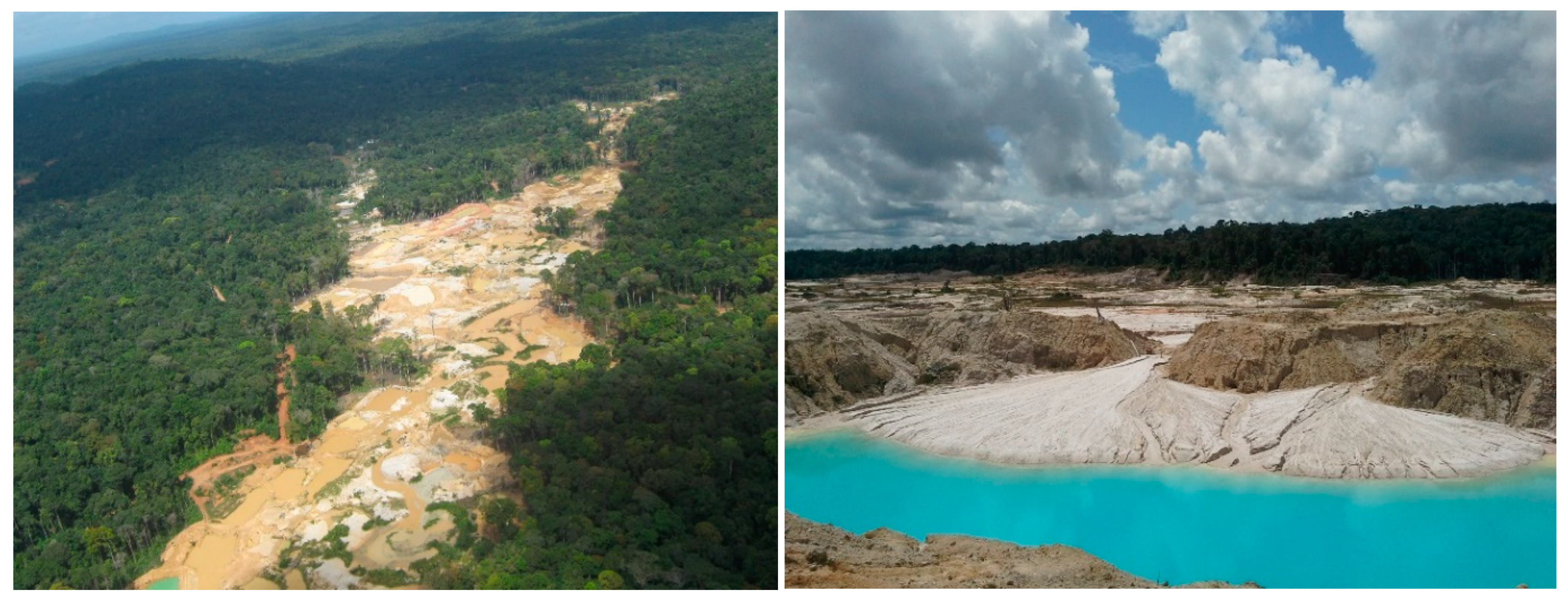
:1. Introduction
2. Materials and Methods
2.1. Data Sets
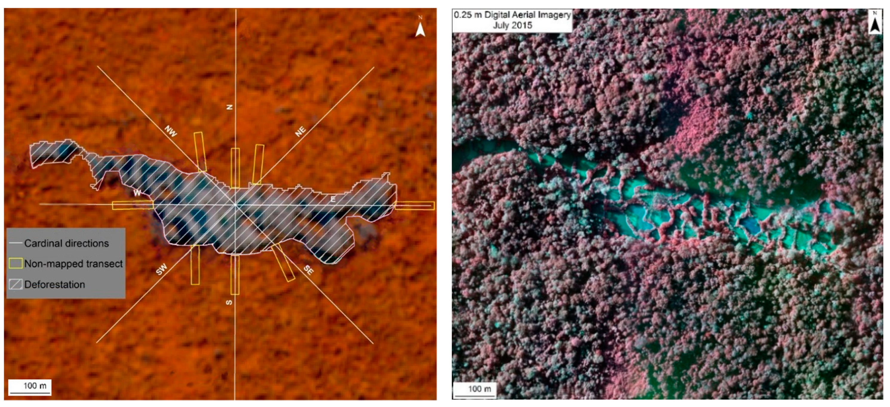
2.2. Remote Sensing Sampling Design
2.3. Field Data Collection
2.4. Data Analysis
2.4.1. Estimation of Carbon Stocks in Aboveground Biomass
- = estimated diameter at breast height, cm;
- = basal diameter, taken at 5 cm above the ground, cm;
- = height of the basal diameter measurement, 5 cm;
- = variation of unit of diameter over a unit of length, 0.79 cm m−1, as derived for and used in Guyana’s forest inventory.
2.4.2. Statistical Analysis
3. Results
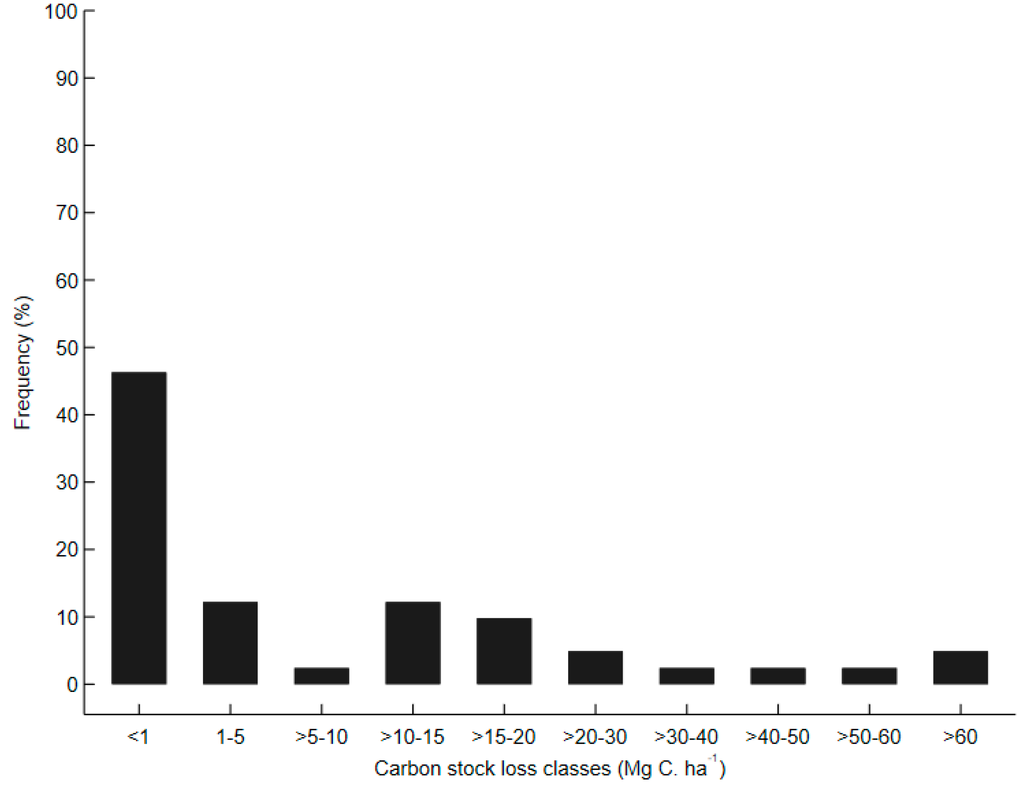
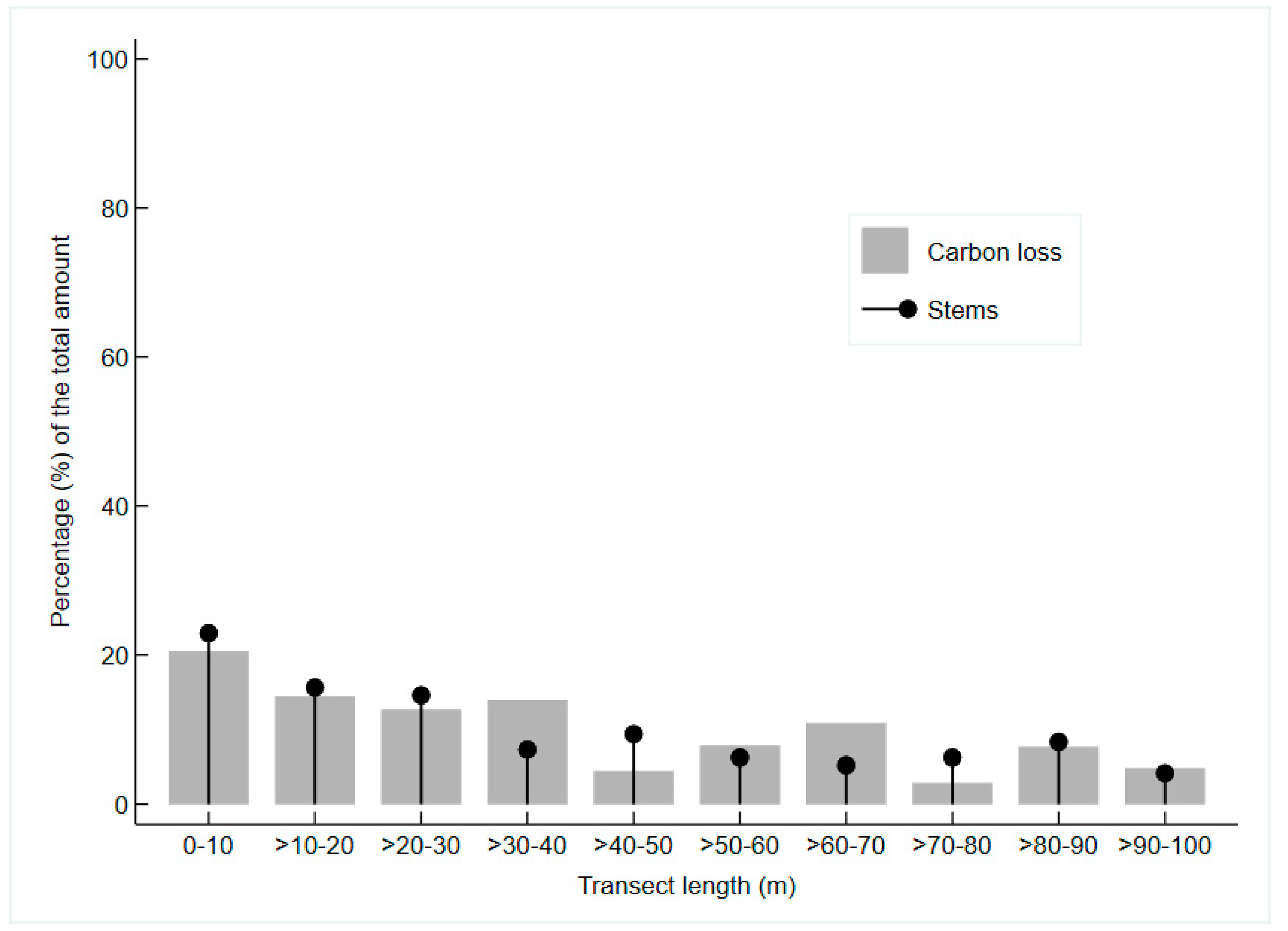
3.1. Change in Carbon Stocks
3.2. Emissions from Mining Degradation Compared to Deforestation Emissions
4. Discussion
5. Conclusions
Author Contributions
Funding
Acknowledgments
Conflicts of Interest
References
- Pearson, T.R.H.; Brown, S.; Murray, L.; Sidman, G. Greenhouse gas emissions from tropical forest degradation: An underestimated source. Carbon Balance Manag. 2017, 12, 3. [Google Scholar] [CrossRef] [PubMed] [Green Version]
- World Bank. FCPF Carbon Fund Methodological Framework; World Bank: Washington, DC, USA, 2016. [Google Scholar]
- Sasaki, N.; Asner, G.P.; Knorr, W.; Durst, P.B.; Priyadi, H.R.; Putz, F.E. Approaches to classifying and restoring degraded tropical forests for the anticipated REDD+ climate change mitigation mechanism. iForest-Biogeosci. For. 2018, 4, 1–6. [Google Scholar] [CrossRef] [Green Version]
- Baland, J.-M.; Bardhan, P.; Das, S.; Mookherjee, D. Forests to the people: Decentralization and forest degradation in the Indian Himalayas. World Dev. 2010, 38, 1642–1656. [Google Scholar] [CrossRef]
- Bahamondez, C.; Thompson, I.D. Determining forest degradation, ecosystem state and resilience using a standard stand stocking measurement diagram: Theory into practice. Forestry 2016, 89, 290–300. [Google Scholar] [CrossRef]
- Bustamante, M.M.; Roitman, I.; Aide, T.M.; Alencar, A.; Anderson, L.O.; Aragão, L.; Asner, G.P.; Barlow, J.; Berenguer, E.; Chambers, J.; et al. Toward an integrated monitoring framework to assess the effects of tropical forest degradation and recovery on carbon stocks and biodiversity. Glob. Chang. Biol. 2016, 22, 92–109. [Google Scholar] [CrossRef]
- Hosonuma, N.; Herold, M.; De Sy, V.; De Fries, R.S.; Brockhaus, M.; Verchot, L.; Angelsen, A.; Romijn, E. An assessment of deforestation and forest degradation drivers in developing countries. Environ. Res. Lett. 2012, 7, 44009. [Google Scholar] [CrossRef]
- Asner, G.P.; Knapp, D.E.; Martin, R.E.; Tupayachi, R.; Anderson, C.A.; Mascaro, J.; Sinca, J.; Chadwick, K.D.; Higgins, M.; Farfan, W.; et al. Targeted carbon conservation at national scales with high-resolution monitoring. Proc. Natl. Acad. Sci. USA 2014, 111, E5016–E5022. [Google Scholar] [CrossRef] [Green Version]
- Asner, G.P.; Llactayo, W.; Tupayachi, R.; Luna, E.R. Elevated rates of gold mining in the Amazon revealed through high-resolution monitoring. Proc. Natl. Acad. Sci. USA 2013, 110, 18454–18459. [Google Scholar] [CrossRef] [Green Version]
- Abood, S.; Lee, J.S.H.; Burivalova, Z.; Garcia-Ulloa, J.; Koh, L.P. Relative contributions of the logging, fiber, oil palm, and mining industries to forest loss in Indonesia. Conserv. Lett. 2015, 8, 58–67. [Google Scholar] [CrossRef] [Green Version]
- Gaveau, D.L.; Sheil, D.; Salim, M.A.; Arjasakusuma, S.; Ancrenaz, M.; Pacheco, P.; Meijaard, E. Rapid conversions and avoided deforestation: Examining four decades of industrial plantation expansion in Borneo. Sci. Rep. 2016, 6, 1–13. [Google Scholar] [CrossRef]
- Campbell, B. Mining in Africa: Regulation and Development; International Development Research Centre (IDRC), The Nordic Africa Institute, Pluto Press: London, UK; New York, NY, USA, 2009. [Google Scholar]
- Céline, E.; Philippe, M.; Astrid, V.; Catherine, B.; Musampa, C.; Pierre, D. National forest cover change in Congo Basin: Deforestation, reforestation, degradation and regeneration for the years 1990, 2000 and 2005. Glob. Chang. Biol. 2013, 19, 1173–1187. [Google Scholar] [CrossRef] [PubMed]
- Laurancea, W.F.; Alfonso, A.; Michelle, L.; Patrick, C. Challenges for forest conservation in Gabon, Central Africa. Futures 2006, 38, 454–470. [Google Scholar] [CrossRef]
- Macdonald, S.E.; Landhäusser, S.M.; Skousen, J.; Franklin, J.; Frouz, J.; Hall, S.; Jacobs, D.F.; Quideau, S. Forest restoration following surface mining disturbance: Challenges and solutions. New For. 2015, 46, 703–732. [Google Scholar] [CrossRef] [Green Version]
- Alvarez-Berríos, N.L.; Aide, T.M. Global demand for gold is another threat for tropical forests. Environ. Res. Lett. 2015, 10, 014006. [Google Scholar] [CrossRef] [Green Version]
- Salo, M.; Hiedanpää, J.; Karlsson, T.; Cárcamo Ávila, L.; Kotilainen, J.; Jounela, P.; Rumrrill García, R. Local perspectives on the formalization of artisanal and small-scale mining in the Madre de Dios gold fields, Peru. Extr. Ind. Soc. 2016, 3, 1058–1066. [Google Scholar] [CrossRef] [Green Version]
- Sanguinetti, S. Fostering Social Change in Peru through Communication: The Case of the Manuani Miners Association. In Handbook of Communication for Development and Social Change; Servaes, J., Ed.; Springer: Singapore, 2018. [Google Scholar] [CrossRef]
- Swenson, J.J.; Carter, C.E.; Domec, J.-C.; Delgado, C.I. Gold Mining in the Peruvian Amazon: Global Prices, Deforestation, and Mercury Imports. PLoS ONE 2011, 6, e18875. [Google Scholar] [CrossRef] [Green Version]
- GOFC-GOLD. A Sourcebook of Methods and Procedures for Monitoring and Reporting Anthropogenic Greenhouse Gas Emissions and Removals Associated with Deforestation, Gains and Losses of Carbon Stocks in Forests Remaining Forests, and Forestation, COP22-1. Ed. GOFC-GOLD Land Cover Project Office, Hosted by Wageningen University, The Netherlands, Wageningen. 2016. Available online: http://www.gofcgold.wur.nl/redd/sourcebook/GOFC-GOLD_Sourcebook.pdf (accessed on 2 October 2020).
- Pearson, T.R.H.; Brown, S.; Casarim, F.M. Carbon emissions from tropical forest degradation caused by logging. Environ. Res. Lett. 2014, 9, 34017. [Google Scholar] [CrossRef] [Green Version]
- Pearson, T.R.H.; Bernal, B.; Hagen, S.C.; Melendy, L.K.; Delgado, G. Remote assessment of extracted volumes and greenhouse gases from tropical timber harvest. Environ. Res. Lett. 2018, 13, 065010. [Google Scholar] [CrossRef]
- Penman, J.; Gytarsky, M.; Hiraishi, T.; Krug, T.; Kruger, D.; Pipatti, R.; Buendia, L.; Miwa, K.; Ngara, T.; Tanabe, K.; et al. IPCC Good Practice Guidance for Land Use, Land-Use Change and Forestry; Institute for Global Environmental Strategies (IGES): Hayama, Japan, 2003; Available online: https://www.ipcc-nggip.iges.or.jp/public/gpglulucf/gpglulucf_files/GPG_LULUCF_FULL.pdf (accessed on 2 October 2020).
- Caballero Espejo, J.; Messinger, M.; Román-Dañobeytia, F.; Ascorra, C.; Fernandez, L.E.; Silman, M. Deforestation and Forest Degradation Due to Gold Mining in the Peruvian Amazon: A 34-Year Perspective. Remote Sens. 2018, 10, 1903. [Google Scholar] [CrossRef] [Green Version]
- Csillik, O.; Asner, G.P. Aboveground carbon emissions from gold mining in the Peruvian Amazon. Environ. Res. Lett. 2020, 15, 014006. [Google Scholar] [CrossRef]
- Lobo, F.L.; Costa, M.; Novo, E.M.L.M. Distribution of artisanal and small-scale gold mining in the Tapajos River basin (Brazilian Amazon) over the past 40 years and relationship with water siltation. Remote Sens. 2016, 8, 579. [Google Scholar] [CrossRef] [Green Version]
- Asner G P and Tupayachi, R. Accelerated losses of protected forests from gold mining in the Peruvian Amazon. Environ. Res. Lett. 2017, 12, 094004. [Google Scholar] [CrossRef]
- Government of the Cooperative Republic of Guyana. The Reference Level for Guyana’s REDD+ Programme; Government of the Cooperative Republic of Guyana: Georgetown, Guyana, 2015. Available online: https://forestry.gov.gy/wp-content/uploads/2016/08/Guyanas-Proposal-for-Reference-Level-for-REDD-Final-Sept-20151.pdf (accessed on 2 October 2020).
- Guyana Forestry Commission. Guyana REDD+ Monitoring Reporting & Verification System (MRVS) Year 8 Interim Measures Report. 2019. Available online: https://forestry.gov.gy/wp-content/uploads/2019/11/Guyana-MRVS-Year-8-Report-Version-1.pdf (accessed on 30 November 2020).
- Guyana Forestry Commission and Indufor. Guyana REDD+ Monitoring Reporting and Verification System (MRVS) Interim Measures Report Year 2 (1 October 2010–31 December 2011) Version 3. Georgetown. 2012. Available online: https://forestry.gov.gy/wp-content/uploads/2015/09/Guyana-MRVS-Interim-Measures-Report-Year-2-V3.pdf (accessed on 2 October 2020).
- Guyana Forestry Commission and Indufor. Guyana REDD+ Monitoring Reporting and Verification System (MRVS) Interim Measures Report Year 4 (1 January–31 December 2013) Version 3. Georgetown. 2015. Available online: https://forestry.gov.gy/wp-content/uploads/2015/09/MRVS-Interim-Measures-Report-Year-4-V3.pdf (accessed on 2 October 2020).
- Sawadogo, L.; Savadogo, P.; Tiveau, D.; Dayamba, S.; Zida, D.; Nouvellet, Y.; Oden, P.; Guinko, S. Allometric prediction of above-ground biomass of eleven woody tree species in the Sudanian savanna-woodland of West Africa. J. For. Res. 2010, 21, 475–481. [Google Scholar] [CrossRef]
- Köhl, M.; Magnusssen, S.; Marchetti, M. Sampling Methods, Remote Sensing and GIS Multiresource Forest Inventory; Springer Science & Business Media: Berlin/Heidelberg, Germany, 2006. [Google Scholar]
- Chave, J.; Andalo, C.; Brown, S.; Cairns, M.A.; Chambers, J.Q.; Eamus, D.; Fölster, H.; Fromard, F.; Higuchi, N.; Kira, T.; et al. Tree allometry and improved estimation of carbon stocks and balance in tropical forests. Oecologia 2005, 145, 87–99. [Google Scholar] [CrossRef] [PubMed]
- Penman, J.; Gytarsky, M.; Hiraishi, T.; Krug, T.; Kruger, D.; Pipatti, R.; Buendia, L.; Miwa, K.; Ngara, T.; Tanabe, K.; et al. IPCC Report on Definitions and Methodological Options to Inventory Emissions from Direct Human-induced Degradation of Forests and Devegetation of Other Vegetation Types; IPCC National Greenhouse Gas Inventories Programme, Institute for Global Environmental Strategies (IGES), Hayama, Japan. 2003. Available online: https://www.ipcc.ch/publication/definitions-and-methodological-options-to-inventory-emissions-from-direct-human-induced-degradation-of-forests-and-devegatation-of-other-vegetation-types/ (accessed on 2 October 2020).
- Ghosh, S. A new graphical tool to detect normality. J. R. Stat. Soc. Ser. B 1996, 58, 691–702. [Google Scholar] [CrossRef]
- Estudillo-Martínez, M.D.; Lozano-Aguilera, E.D.; Castillo-Gutiérrez, S. New confidence bands in Q–Q Plots to detect non-normality. Int. J. Comput. Math. 2013, 90, 2137–2146. [Google Scholar] [CrossRef]
- Wilcoxon, F. Individual Comparisons by Ranking Methods. Biom. Bull. 1945, 1, 80–83. [Google Scholar] [CrossRef]
- Mann, H.B.; Whitney, D.R. On a Test of Whether one of Two Random Variables is Stochastically Larger than the Other. Ann. Math. Stat. 1947, 18, 50–60. [Google Scholar] [CrossRef]
- Mood, A.M.; Graybill, F.A. Introduction to the Theory of Statistics, 2nd ed.; McGraw-Hill: New York, NY, USA, 1963. [Google Scholar]
- Efron, B.; Tibshirani, R. Bootstrap methods for standard errors, confidence intervals, and other methods of statistical accuracy. Stat. Sci. 1986, 1, 54–77. [Google Scholar] [CrossRef]
- Efron, B.; Tibshirani, R.J. An Introduction to Bootstrap; Chapman & Hall: New York, NY, USA, 1993. [Google Scholar]
- Hall, P.; Wilson, S.R. Two guidelines for bootstrap hypothesis testing. Biometrics 1991, 47, 757–762. [Google Scholar] [CrossRef] [Green Version]
- Efron, B. The Jackknife, the Bootstrap and Other Resampling Plans; Society for Industrial and Applied Mathematics: Philadelphia, PA, USA, 1982. [Google Scholar]
- Maxwell, S.L.; Evans, T.; Watson, J.E.M.; Morel, A.; Grantham, H.; Duncan, A.; Harris, N.; Potapov, P.; Runting, R.K.; Venter, O.; et al. Degradation and forgone removals increase the carbon impact of intact forest loss by 626%. Sci. Adv. 2019, 5, eaax2546. [Google Scholar] [CrossRef] [PubMed] [Green Version]
- Goslee, K.M.; Pearson, T.R.H.; Bernal, B.; Simon, S.L.; Sukhdeo, H. Comprehensive Accounting for REDD+ Programs: A Pragmatic Approach as Exemplified in Guyana. Forests 2020, 11, 1265. [Google Scholar] [CrossRef]
- Chave, J.; Réjou-Méchain, M.; Búrquez, A.; Chidumayo, E.; Colgan, M.S.; Delitti, W.B.; Duque, A.; Eid, T.; Fearnside, P.M.; Goodman, R.C.; et al. Improved allometric models to estimate the aboveground biomass of tropical trees. Glob. Chang. Biol. 2014, 20, 3177–3190. [Google Scholar] [CrossRef] [PubMed]
- Ryan, C.M.; Hill, T.; Woollen, E.; Ghee, C.; Mitchard, E.; Cassells, G.; Grace, J.; Woodhouse, I.H.; Williams, M. Quantifying small-scale deforestation and forest degradation in African woodlands using radar imagery. Glob. Chang. Biol. 2012, 18, 243–257. [Google Scholar] [CrossRef] [Green Version]
- Pereira, R.; Zweede, J.; Asner, G.P.; Keller, M. Forest canopy damage and recovery in reduced-impact and conventional selective logging in eastern Para, Brazil. For. Ecol. Manage. 2002, 168, 77–89. [Google Scholar] [CrossRef]
- Asner, G.P.; Powell, G.V.; Mascaro, J.; Knapp, D.E.; Clark, J.K.; Jacobson, J.; Kennedy-Bowdoin, T.; Balaji, A.; Paez-Acosta, G.; Victoria, E.; et al. High-resolution forest carbon stocks and emissions in the Amazon. Proc. Natl. Acad. Sci. USA 2010, 107, 16738–16742. [Google Scholar] [CrossRef] [Green Version]
- Amoako, Y.K.; Gordon, C.; Sakyi, P.A.; Gyimah, R. Carbon Footprint of the large scale gold mining industry of Ghana. West Afr. J. Appl. Ecol. 2018, 26, 242–260. [Google Scholar]


| Data Type | Data Products | Period | Data Source | |
|---|---|---|---|---|
| Vector | Guyana forest change map 2011 (year 2) | October 2010–December 2011 | Guyana Forestry Commission | |
| Guyana forest change map 2012 (year 3) | January 2012–December 2012 | |||
| Guyana forest change map 2013 (year 4) | January 2013–December 2013 | |||
| Raster | 5 m-RapidEye Satellite Imagery | 2011–2014 | ||
| Ground survey | 41 rectangular transects of 20 m × 100 m (0.2 ha) each | July–August 2015 | Primary Data | |
| Year | No. of transects | |||
| 2011 | 11 | |||
| 2012 | 16 | |||
| 2013 | 14 | |||
| Total | 41 | |||
| Year | # of Transects | Min | Max | Mean | Median | Bootstrap Bias | BootstrapStandard Error | 95% Confidence Interval | |
|---|---|---|---|---|---|---|---|---|---|
| Lower | Upper | ||||||||
| 2011 | 11 | 0.0 | 57.1 | 10.5 | 4.3 | 1.0 | 4.8 | 0.0 −5.2 0.0 0.2 | 16.1 (p) 13.8 (BN) 15.2 (BP) 18.3 (BCa) |
| 2012 | 16 | 0.0 | 70.3 | 10.1 | 0.9 | 0.7 | 2.2 | 0.0 −3.5 0.0 0.0 | 8.4 (p) 5.2 (BN) 7.3 (BP) 8.5 (BCa) |
| 2013 | 14 | 0.0 | 96.7 | 16.3 | 8.5 | −0.9 | 5.4 | 0.0 −2.1 0.0 0.0 | 19.0 (p) 19.2 (BN) 16.7 (BP) 16.0 (BCa) |
| Total | 41 | 0.0 | 96.7 | 12.3 | 2.2 | 0.8 | 2.8 | 0.0 −3.4 0.0 0.0 | 10.2 (p) 7.8 (BN) 10.2 (BP) 10.2 (BCa) |
| Year | # of Transects | Z Value | Probability (p) Value a |
|---|---|---|---|
| 2011 | 11 | −0.684 | 0.494 (0.577) |
| 2012 | 16 | ||
| 2011 | 11 | −0.139 | 0.889 (0.484) |
| 2013 | 14 | ||
| 2012 | 16 | −0.838 | 0.402 (0.413) |
| 2013 | 14 |
| Year | Live Tree a | Mining Damage b | Other Damage b | Total Aboveground a Biomass (Live Biomass + Biomass of All Damage) |
|---|---|---|---|---|
| 2011 | 201.0 | 4.3 | 12.1 | 230.0 |
| 2012 | 188.8 | 0.9 | 12.8 | 215.0 |
| 2013 | 183.2 | 8.5 | 8.1 | 211.8 |
| All | 190.2 (±27.6) | 2.2 (0.0–10.2) | 11.6 (1.6–17.5) | 218.0 (±29.4) |
| Emission Source | Emissions (Million Mg CO2·yr−1) | Percentage of Total Emissions in Guyana |
|---|---|---|
| Deforestation by all causes | 13.2 | 76% |
| Forest degradation by all causes † | 4.1 | 24% |
| Deforestation from mining | 10.7 | 62% |
| Forest degradation from timber harvest | 3.8 | 22% |
| Forest degradation from mining | 0.3 | 2% |
Publisher’s Note: MDPI stays neutral with regard to jurisdictional claims in published maps and institutional affiliations. |
© 2020 by the authors. Licensee MDPI, Basel, Switzerland. This article is an open access article distributed under the terms and conditions of the Creative Commons Attribution (CC BY) license (http://creativecommons.org/licenses/by/4.0/).
Share and Cite
Brown, S.; Mahmood, A.R.J.; Goslee, K.M.; Pearson, T.R.H.; Sukhdeo, H.; Donoghue, D.N.M.; Watt, P. Accounting for Greenhouse Gas Emissions from Forest Edge Degradation: Gold Mining in Guyana as a Case Study. Forests 2020, 11, 1307. https://doi.org/10.3390/f11121307
Brown S, Mahmood ARJ, Goslee KM, Pearson TRH, Sukhdeo H, Donoghue DNM, Watt P. Accounting for Greenhouse Gas Emissions from Forest Edge Degradation: Gold Mining in Guyana as a Case Study. Forests. 2020; 11(12):1307. https://doi.org/10.3390/f11121307
Chicago/Turabian StyleBrown, Sandra, Abu R. J. Mahmood, Katherine M. Goslee, Timothy R. H. Pearson, Hansrajie Sukhdeo, Daniel N. M. Donoghue, and Pete Watt. 2020. "Accounting for Greenhouse Gas Emissions from Forest Edge Degradation: Gold Mining in Guyana as a Case Study" Forests 11, no. 12: 1307. https://doi.org/10.3390/f11121307