Article

Revisiting “Southern” Sprawl: Urban Growth, Socio-Spatial Structure and the Influence of Local Economic Contexts

1
Council for Agricultural Research and Economics (CREA), Via della Navicella 2-4, I-00184 Rome, Italy
2
Department of Agriculture, Forest, Nature and Energy (DAFNE), University of Tuscia, Via S. Camillo de Lellis, I-01100 Viterbo, Italy
3
Department of Architecture and Planning, “Sapienza” University of Rome, Via Flaminia 369, I-00196 Rome, Italy
4
Grumets Research Group, Department of Geografia, Edifici B, Universitat Autònoma de Barcelona, EL-08193 Bellaterra, Spain
5
Department of Social and Economic Science, “Sapienza” University of Rome, Piazzale A. Moro 5, I-00185 Rome, Italy
*
Author to whom correspondence should be addressed.
Economies 2015, 3(4), 237-259; https://doi.org/10.3390/economies3040237
Submission received: 24 August 2015 / Revised: 30 November 2015 / Accepted: 15 December 2015 / Published: 21 December 2015
(This article belongs to the Special Issue Urban Economy)

Abstract

:
Given its unpredictable nature, urban sprawl in the Mediterranean region is considered an intriguing (and intricate) socioeconomic issue. Since the 1970s, urban dispersion advanced rapidly in southern Europe—irrespective of a city’s size and morphology—with urbanization rates growing faster than population. A comparison between the metropolitan areas of Barcelona, Rome and Athens reveals how sprawl has occurred in different ways in the three cities, highlighting peculiar relationships between urbanization, land-use and economic structures. Sharing common drivers of change related to population dynamics, socio-spatial structure and deregulated urban expansion, sprawl has adapted to the local economic, cultural and environmental context. Barcelona shows a dispersion pattern towards a more spatially-balanced morphology, with expanding sub-centres distributed around the central city, Rome appears to be mostly scattered around the historical city with fragmented urban fabric and heterogeneous economic functions, Athens is denser, with polarized economic spaces and social segregation. Understanding how place-specific factors influence processes of settlement dispersion in Mediterranean contexts may inform policies of urban containment and land-use management.
JEL Classifications:
C38; O18; O52; R11; R15; R58

1. Introduction

Dispersed urban expansion, a phenomenon known worldwide with the term “urban sprawl”, determines changes in both urban patterns (e.g., settlement morphology and urban form) and processes (spatial distribution of economic functions, socio-spatial disparities, political and cultural factors consolidating the role of peri-urban areas). Physical elements related to space, have been extensively evaluated in order to analyse how sprawl has manifested and taken place in metropolitan regions (Southworth and Owens, 1993 [1]; Tsai, 2005 [2]; Kazepov, 2005 [3]; Couch et al., 2007 [4]). Urban sprawl would be possible under a variety of political, economic and cultural conditions which manifested itself worldwide (Burchell et al., 1998 [5]). Sprawl is identifiable in suburban areas where low-density residential settlements have progressively replaced the traditional agricultural and forest mosaic leading to a mixed and undefined landscape, disseminated of detached family houses, where population is highly dependent on private transport (Ewing et al., 2002 [6]; Tsai, 2005 [2]; Torrens, 2008 [7]). The main causes of sprawl can be envisaged in (i) a complex system of interacting agents at the base of the dispersed expansion of cities and metropolitan regions (Gargiulo Morelli and Salvati, 2010 [8]); (ii) lack of efficient planning systems at the regional scale and, more frequently, at the urban scale (Gibelli and Salzano, 2006 [9]); (iii) a generalized misuse of non-urban land determined by policies regulating cities’ growth and the development of peri-urban regions (Giannakourou, 2005 [10]).
Sprawl can be thus considered an intriguing spatial model involving social, economic and environmental issues and reflecting the interplay between urban patterns and development processes (Burchell et al., 1998 [5]; Galster et al., 2001 [11]; Frenkel and Ashkenazi, 2008 [12]; Orenstein et al., 2013 [13]). Since sprawl is based on a number of interacting factors, it is difficult to understand how urban dispersion is structured over time and scale (Kazepov, 2005 [3]; Couch et al., 2007 [4]; Cassier and Kesteloot, 2012 [14]), making it difficult to implement appropriate strategies of urban containment and sustainable land-use management policies (Bruegmann, 2005 [15]; Hall and Pain, 2006 [16]; Angel et al., 2011 [17]). From these premises, sprawl appears to be a key issue for contemporary cities, due to the overpowering degree of laissez-faire policies (Costa et al., 1991 [18]).
Southern Europe is an interesting case for studying the impact of dispersed urban expansion on different models of local development. The spread of low-density settlements from inner cities to suburban areas is a traditional phenomenon for North American cities observed since the beginning of the twentieth century (e.g., Duany et al., 2000 [19]; Bruegmann, 2005 [15]). By contrast, sprawl can be identified as an untraditional—and possibly more recent—development model for some European cities, especially those situated in the Mediterranean Europe (European Environment Agency, 2006 [20]; Kasanko et al., 2006 [21]; Couch et al., 2007 [4]). From the 1970s, urban dispersion advanced rapidly in European Mediterranean cities, with urbanization rates growing much faster than population. This trend was observed in Barcelona (Catalán et al., 2008 [22]), Marseilles and the nearby Rhone valley (Pinson and Thomann, 2001 [23]), Rome (Munafò et al., 2010 [24]) and Athens (Salvati et al., 2013 [25]), among others. The diffusion of sparse settlements driven by population de-concentration since the early 1980s has created a mixed landscape around the main cities and is considered a relevant socioeconomic challenge in the Mediterranean region (Alphan, 2003 [26]; Catalán et al., 2008 [22]; Terzi and Bolen, 2009 [27]; Salvati and Sabbi, 2011 [28]). According to the projections proposed by United Nations Urbanization Prospects (derived from the website esa.un.org [29]), urban population will be 72% in Greece, 76% in Italy, 82% in Portugal and France, and 85% in Spain by 2030. Projections highlight the growing pressure for metropolitan urbanization that Southern Europe will experience in the near future.
The key words emerging from rapidly-changing local contexts are diversification, entropy and isolation, among others (Burgel, 2004 [30]). Contemporary cities in southern Europe take on a polarized spatial structure emphasizing population disparities (Delladetsima, 2006 [31]; Leontidou et al., 2007 [32]). The economic space became fragmented assuming a spatial organization hardly classifiable as “polycentric” (Giannakourou, 2005 [10]; Maloutas, 2007 [33]) and with relevant services and infrastructural divides at the local scale (Leontidou, 1990 [34]; Krumholtz, 1992 [35]). Long-term trajectories in Mediterranean urbanization—supposedly converging at the regional scale—contrast with patterns and trends in urban expansion which are characteristics of each country and possibly of each city investigated.
The present study proposes an interpretation of “southern” urbanization with less common aspects and more differences at the regional scale. Sprawl is intended as a recent urbanization pattern exemplificative of this challenge, moving from a unifying “Mediterranean” vision to city-specific “growth and change” processes characterizing the southern European urban arena (Kasanko et al., 2006 [21]). The cases of Barcelona, Rome and Athens are considered in the present study. These cities share similar territorial characters, showing a unique structure and socioeconomic configuration. Sprawl has adapted to their contexts in different ways depending on historical, cultural and political issues. Exhibiting a regional or national capital role, these cities have hosted competitive events of global importance, such as in the case of Athens and Barcelona with the Olympic Games. A narrative comparison of the recent processes of urban growth reveals how sprawl has occurred at the metropolitan scale and the apparent and latent connections between compact urbanization, land-use and economic structure observed in the three cities.
The article is organized as follows: a comparative framework is proposed in Section 2 by illustrating the local context in the three cities based on the in-depth analysis of demographic, land-use and socioeconomic indicators derived from official statistics at a disaggregated spatial scale. Section 3 reframes the specific patterns and processes of sprawl in Mediterranean Europe providing narrative examples of the recent growth observed in the three cities. Section 4 summarizes and discusses the evidence proposed in our study providing an original interpretation of urban sprawl in Barcelona, Rome and Athens, taken as distinct patterns and processes based on the complex interplay of place-specific territorial and socioeconomic factors. By integrating narrative and quantitative approaches, we provide elements to “reset” the scene of “southern” sprawl revisiting the main socioeconomic drivers of change in contemporary Mediterranean cities.

2. Setting the Scene: A Comparative Analysis of the Socioeconomic Context in the Three Cities

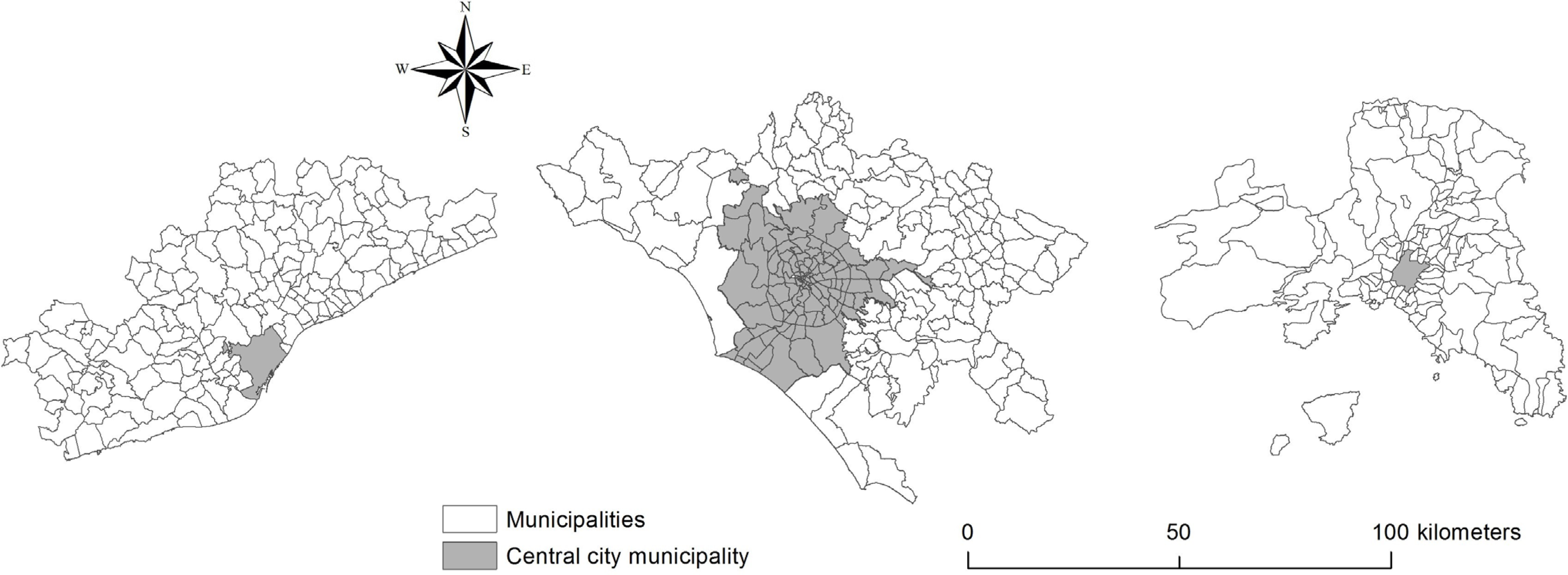
Together with the difficulty in analysing patterns and processes of dispersed urban expansion from the socioeconomic point of view, there is a lack of basic information required to perform this type of analysis at a spatially disaggregated geographical scale. The absence of unifying databases containing homogeneous and relevant diachronic information complicates the comparison between metropolitan areas when identifying different types of sprawl patterns and processes. The present study outlines a comprehensive picture of the recent development of Barcelona, Rome and Athens based on a set of contextual indicators with the aim to assess a variety of socioeconomic issues related with sprawl. We implement a narrative approach based on the simplified analysis of maps and the spatial distribution of indicators derived from official statistics and other data sources, integrated with a bibliographic analysis of recent publications in the field of urban studies in Europe—and especially in Southern Europe. We used local administrative boundaries (namely the NUTS-5 level of the European Territorial Classification of Statistical Units) as the elementary spatial domain of analysis (Figure 1).
Figure 1. Maps of Barcelona (left), Rome (middle) and Athens (right) study areas illustrating the boundaries of local municipalities and the position of the central city.
Economies 03 00237 g001

2.1. The Intimate Pattern of Sprawl: Unravelling Land-Use Patterns

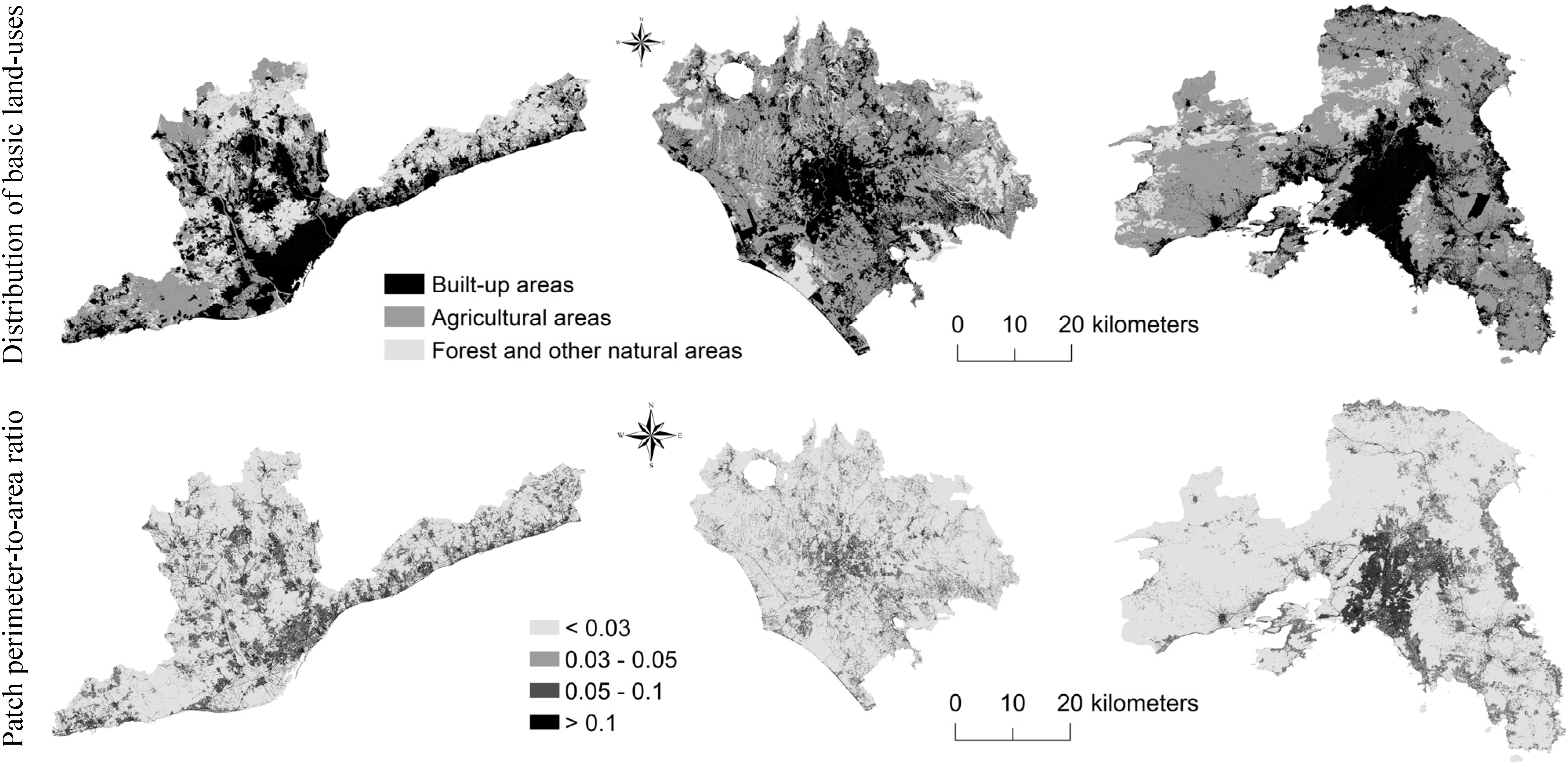
Data on the total surface of the three metropolitan areas and population density are provided in Table 1 using information derived from the Urban Atlas, an initiative of the European Environment Agency producing high-resolution land-use maps scaled 1:10,000 for a number of metropolitan areas, and official statistics. Metropolitan areas were identified using commuting data from the most recent population census. Land-use maps were elaborated using a nomenclature based on three classes: (i) built-up areas; (ii) cropland and non-forest natural areas and (iii) forests (Figure 2). The three cities show different morphologies: compact settlements in Athens, semi-dense and discontinuous settlements in Rome and a more aggregated and spatially-balanced urban fabric in Barcelona. A landscape metric (perimeter-to-area ratio, intended as a widely-used shape index) was finally calculated for each land patch and mapped to identify urban districts with higher land fragmentation.
Table 1. Basic characteristics of the three metropolitan regions.
CitySurface Area (km2)PopulationPopulation Density (Inhab/km2)
Barcelona32424,394,4121355
Rome53523,700,424691
Athens30253,724,3931231
Figure 2. Land-use maps in Barcelona (left), Rome (middle) and Athens (right).
Economies 03 00237 g002
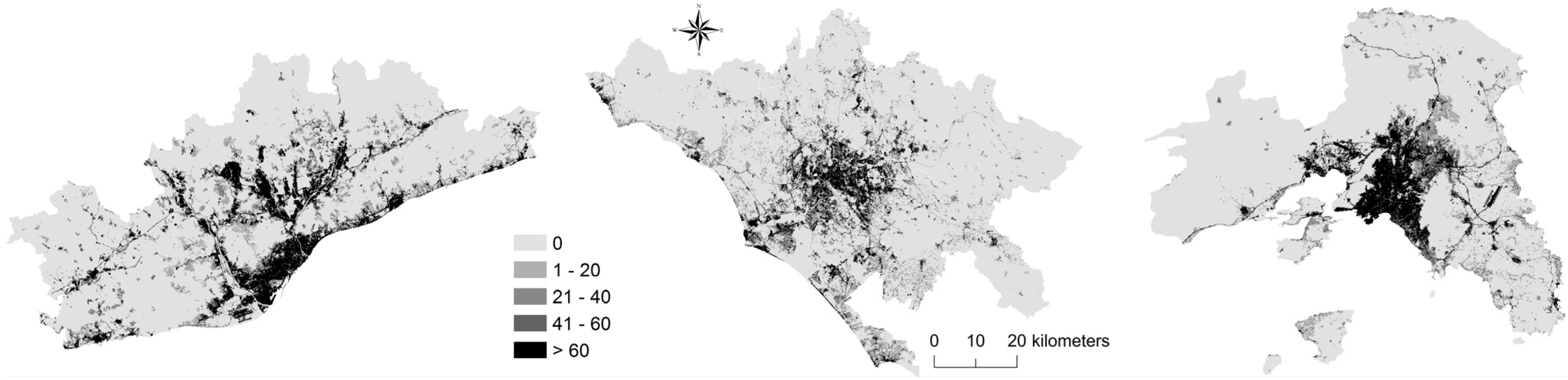
Maps indicate that the spatial distribution of Athens settlements is rather dense and compact; Rome settlements are more dispersed over the metropolitan area while the Barcelona metropolitan structure shows an intermediate pattern of urban expansion. A morphological analysis of the three regions was carried out on the basis of the level of soil sealing due to urbanization (Figure 3). Soil sealing is one of the major challenges that Europe faces today because it produces negative environmental impacts, reflecting the “footprint” of each city (Salvati and Sabbi, 2011 [28]). We use a high-resolution map covering the whole of Europe and produced by European Environment Agency referring to the year 2006. The map consists of a raster data set of built-up and non built-up areas including continuous degree of soil sealing based on multi-sensor and bi-temporal, ortho-rectified satellite imagery. The map represents the degree of sealing with a percentage scale from 0 to 100, respectively, from non-urbanized areas to hyper-compact settlements, identifying urban contexts where sealing values are greater than 60%. Impervious surfaces were defined as pavement structures (roads, sidewalks, driveways and parking lots) covered by asphalt, concrete, brick, stone and rooftops. Table 2 reports the percentage area of each soil sealing class. Maps well illustrate the compactness of Athens settlements, the discontinuity and heterogeneity of Rome settlements and the polarization in high and low density settlements observed in Barcelona.
Figure 3. Percentage degree of soil sealing in the three cities.
Economies 03 00237 g003
Table 2. Percentage of soil sealing by class in the three cities.
Class (%)BarcelonaRomeAthens
072.076.575.4
1–209.910.98.1
21–405.14.94.5
41–603.62.83.5
>609.44.98.5

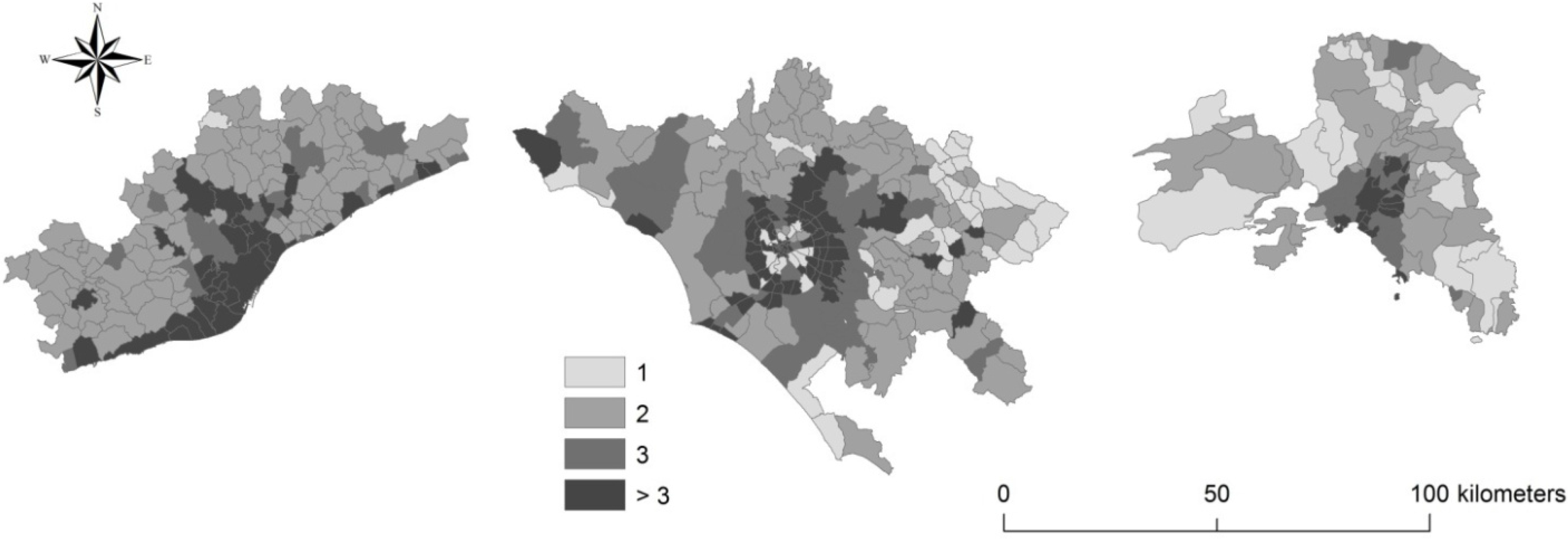
2.2. Population Growth and Urban Expansion

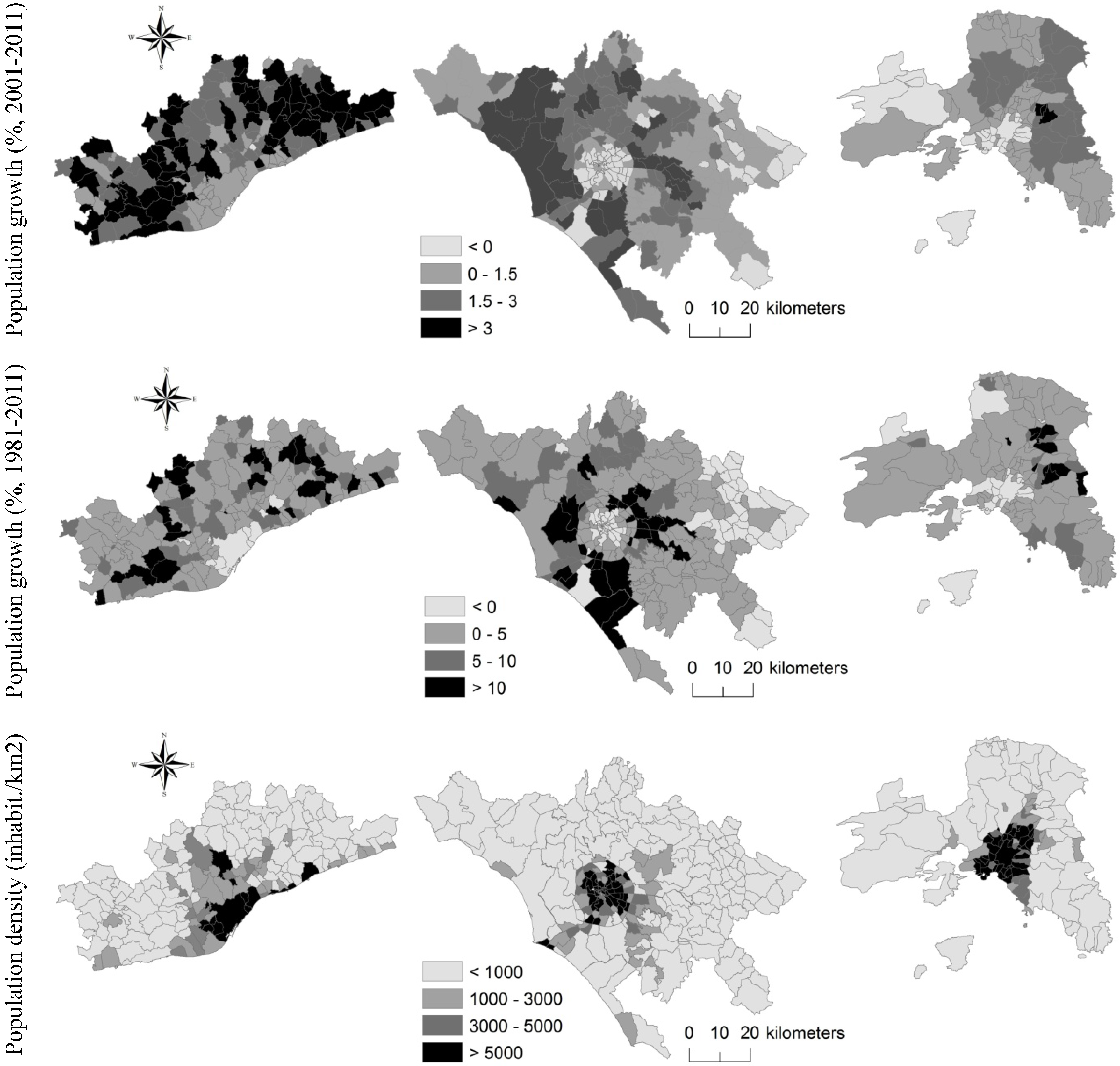
The analysis of population growth may contribute to assess urban sprawl phenomena (Salvati and De Rosa, 2014 [36]). Three indicators were considered when assessing local-scale urban concentration or dispersion: population growth (i) in the short-term (2001–2011) and (ii) in the long-term (1981–2011) as well as (iii) population density. All indicators were derived from national censuses of population held by the representative National Statistical Office in Spain, Italy and Greece. These indicators allow focusing on the relocation of population in the outer fringe as a consequence of sprawl dynamics (Figure 4). Maps show that areas surrounding central cities are more attractive because of a growing population in respect to the neighbouring dense areas, contributing to consolidating urban sprawl.
Barcelona experienced diffused population growth in the last decade and a demographic stability with scattered expansion in the last three decades. Population growth in Rome was diffused along radial axes opposed to the inner city, reproducing a fragmented landscape at distances progressively further away from the central districts (Salvati et al., 2013 [25]). In the last 30 years, municipalities with the largest increase in resident population were situated in the outer ring of Rome and particularly along coastal areas. The central city showed a moderate decrease in resident population, more pronounced in the last decade. Population growth in Athens was relatively stable over time, although with a moderate decrease in the central city over the last decade, possibly reflecting the opposition between shrinking industrial areas (such as Piraeus and surrounding districts) and sprawling eastern suburbs close to the international airport. Population density discriminates Barcelona and Athens, which are more compact than Rome, dominated by discontinuous settlements.
Figure 4. Recent population dynamics in the three cities
Economies 03 00237 g004

2.3. Urban Morphology and Infrastructures

City morphology is usually shaped by the interplay between biophysical, socio-demographic, economic, cultural and political contexts. A comparative analysis of urban design features, such as topography, infrastructural networks (e.g., roads, railways) and settlement patterns, contributes to understanding how settlement morphology differs at the regional scale in Barcelona, Rome and Athens. For example, the elevation gradient is an important element shaping urban form and settlement expansion in the Mediterranean region. Rugged topography and sloping landscapes reduce the availability of buildable land, promoting more compact centres and urban growth mainly along the sea coasts or in the main lowland. The three cities were characterized by different elevation profiles as represented in Figure 5. Athens metropolitan region shows a rugged topography with more than 80% of the surface area classified as hilly or mountainous (>200 m elevation). Rome expanded over the alluvial plain of the Tiber river with buildable land restricted by the Apennine mountain chain east of the central city. Barcelona is in an intermediate condition, with buildable land distributed along the sea coast and in some internal flat areas in correspondence with river valleys of regional importance.
Figure 5. Classification of local municipalities in each study region based on mean elevation (m).
Economies 03 00237 g005
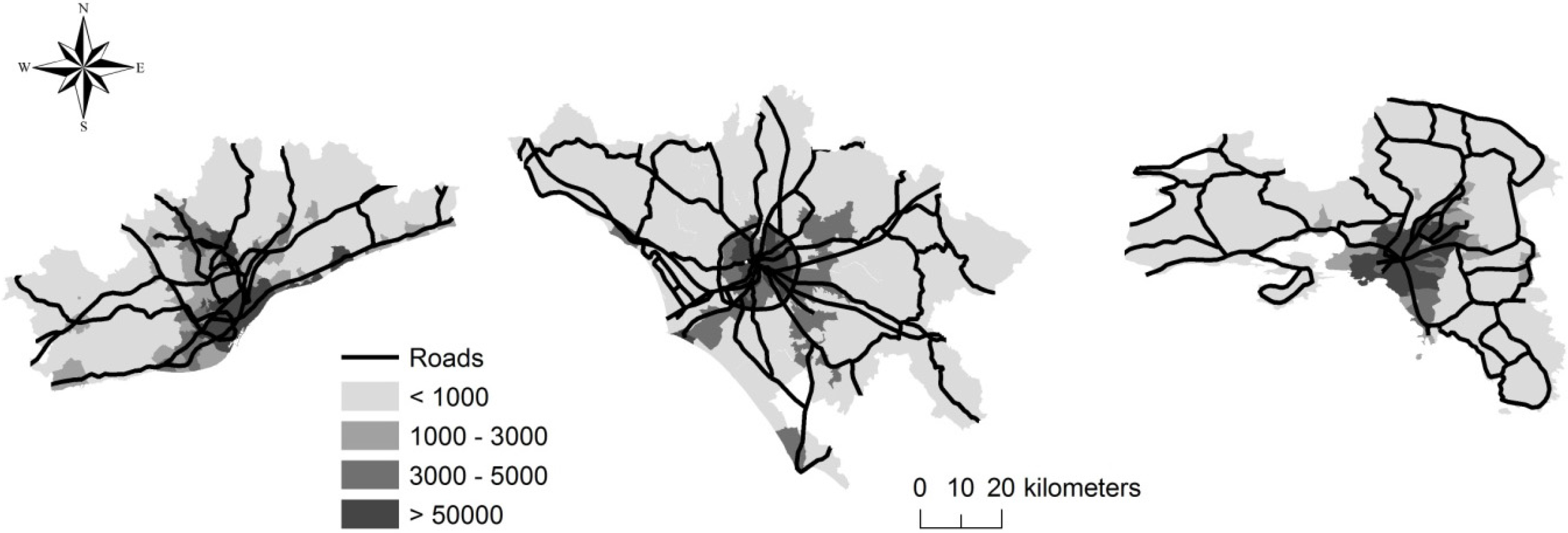
The spatial analysis of the main road network allows identifying central cities. We provide maps where the road network overlaps a population density layer (Figure 6). The analysis highlights three different urban forms. In the case of Barcelona, the road network expands by connecting to other urban centres in the metropolitan area; in the case of Rome, the ring road concentrates the highest population density, which decreased gradually outside; finally, in the case of Athens, population density is low in the metropolitan area, growing in close proximity to Athens and Piraeus, where the roads are intertwined with each other.
Figure 6. Main road network and population density (inhabitant/km2) in the three cities.
Economies 03 00237 g006
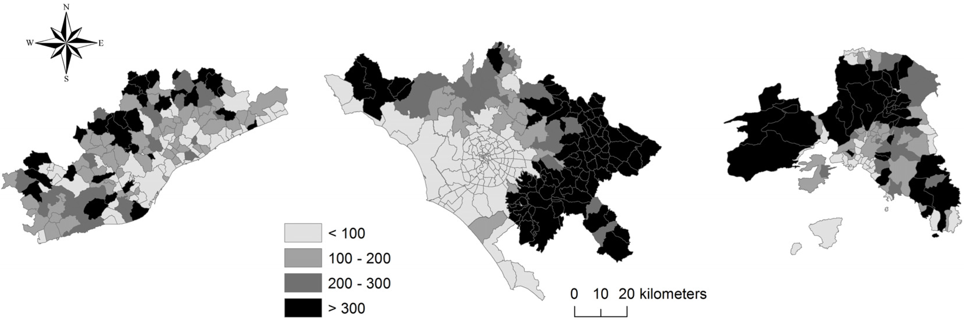
Sprawl is associated with low density settlements composed of individual houses, in contrast to urban realities in which population density is high and buildings host several dwellings together. An indicator which compares the number of dwellings per buildings derived from the national censuses of buildings at the municipal level is proposed in Figure 7. A value approaching 1 means that for every building there is only one dwelling, or just a household lives there. This indicator is suitable to identify low-density settlements as a characteristic pattern of urban dispersion. Consolidated urban areas have high values of the indicator; the lowest values are observed in peri-urban areas in both Athens and Barcelona and around the central municipality of Rome, confirming the spatial heterogeneity typical of the Italian capital compared to the Spanish and Greek cities.
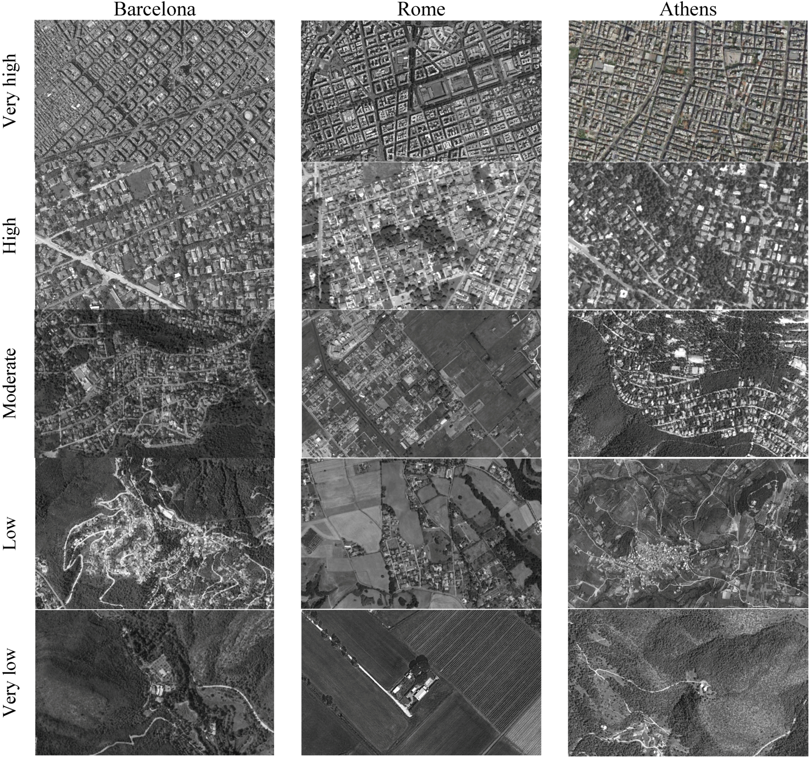
Aerial photographs finally allow understanding the main components of the urban landscape, identifying patterns of sprawl and summarizing the main results derived from the morphological indicators illustrated above. The following pictures (Figure 8) are intended as a comprehensive sample of urban fabrics, passing from hyper-compact settlements to the most typical contexts of sprawl, responding to the requirements of the socioeconomic indicators analyzed in the following sections.
Figure 7. Number of dwellings per building in the three cities.
Economies 03 00237 g007
Figure 8. Settlement distribution patterns in the three cities by building density.
Economies 03 00237 g008

2.4. The Social Context

Four indicators were calculated and mapped at the municipal scale with the aim to assess the dominant social context in the three cities (Figure 9): (i) percentage of households with one component in the total number of households; (ii) elderly index taken as a proxy for aging processes; (iii) percentage of foreigners (non-native people) in the total resident population; and (iv) percentage of graduates in the total resident population. These indicators were derived from the national censuses of population and allow for a comprehensive picture of the socio-spatial urban structure based on population structure, demographic dynamics and education level, considered as relevant factors of sprawl (Torrens, 2008 [7]; Gargiulo Morelli and Salvati, 2010 [8]; Gibelli and Salzano, 2006 [9]).
The average number of components per family is rather similar in the three cities. Barcelona shows values ranging from 1.7 to 2.8, with prevalence of medium-small households, with 2.4 average components at the metropolitan scale. Athens shows moderately higher values ranging between 2.3 and 4.0, with 3.2 components per family on average. Rome ranks in the middle with average household size amounting to 2.9. In all cities, large households tend to settle in suburban areas. By contrast, one-component households settled prevalently in consolidated urban areas. According to López-i-Villanueva et al. (2013) [37], household structure affects housing demand. One-component households (e.g., older people or adults who live alone) are concentrated in urban areas, due to their preference to have more accessibility to services, while large families, usually composed by a couple with two or more children, choose residential neighbourhoods, surrounded by natural amenities and with low population density. Figure 9 confirms this spatial trend outlining that the highest number of households composed of one person is concentrated in dense urban areas decreasing (more or less) rapidly in the metropolitan region of all cities investigated.
The elderly index completes the picture illustrating a distribution of elder population around the central city of Barcelona, while inland, rural municipalities showed high values of the index, together with some urban districts in Rome. In Athens, population aging was observed in the urban area and, more scattered, in some coastal and inland peri-urban municipalities. The spatial distribution of the elderly index reflects the dominant demographic pattern in the three cities possibly influencing the overall process of sprawl. The proportion of foreign resident population was also discriminating among cities: Athens host the largest foreign population compared with Barcelona and Rome. By contrast, the spatial distribution of graduates (tertiary education) follows a typical urban gradient in all cities, being higher in the central city and decreasing in peri-urban areas. However, differences can be observed between Barcelona and Athens, with a more spatially-polarized distribution of graduates in Athens compared with Barcelona.
Figure 9. Social indicators in the three cities.
Economies 03 00237 g009

2.5. The Economic Structure

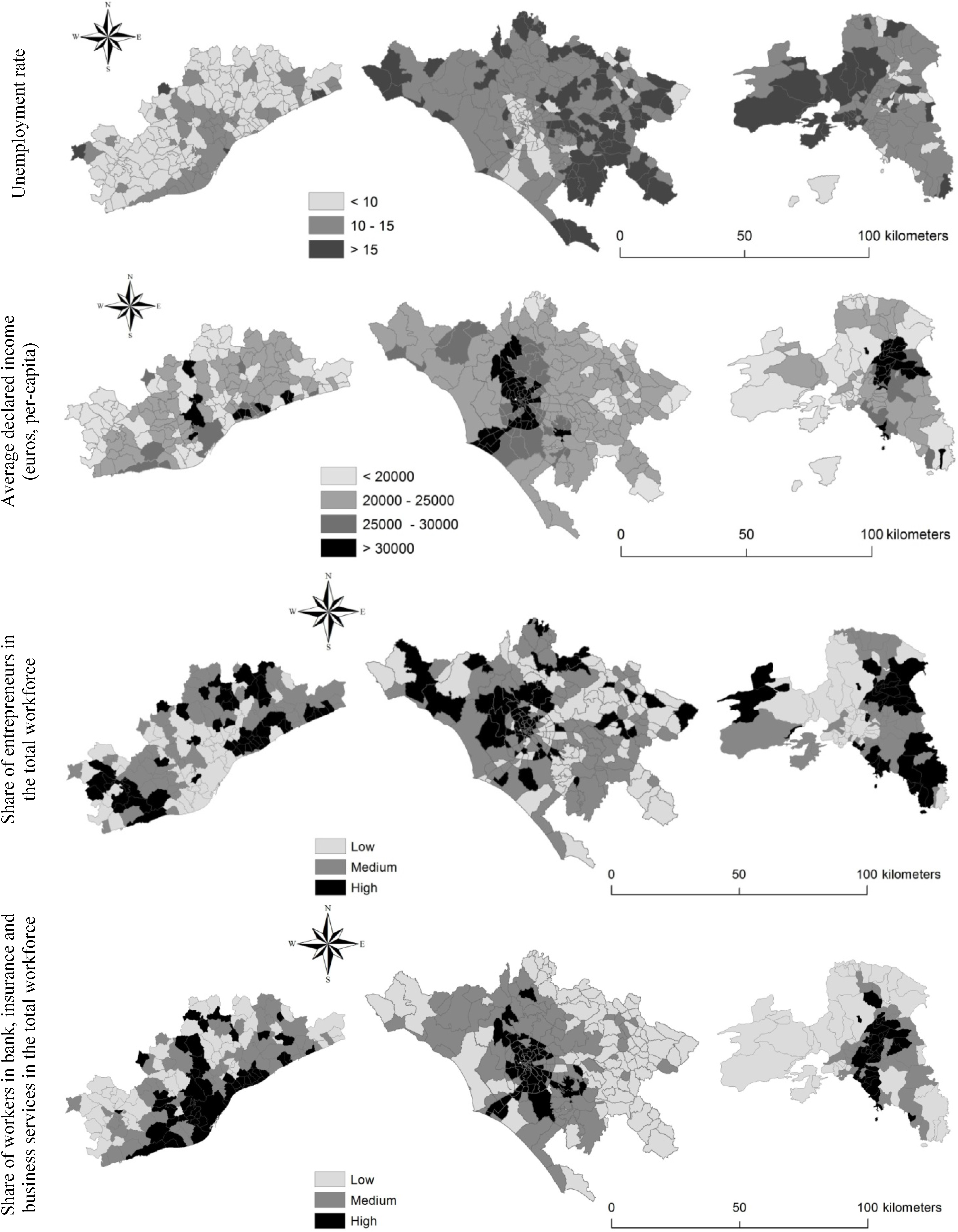
Economic indicators allow identifying the peculiar features and functions that characterize each metropolitan region. The productive structure of the three cities was investigated considering (i) unemployment rate; (ii) average per-head declared income; (iii) share of entrepreneurs in the total resident population; and (iv) share of workers in credit, insurance and business services in the total workforce, as relevant indicators derived from the National Censuses of Population (Figure 10). The employment rate is the highest in Barcelona (58% on average); in Rome, several municipalities have a low or medium-low employment rate, while in Athens high employment rates can be observed especially in Eastern Attica. Unemployment rate is lower in Barcelona and much higher in Rome while in Attica an east-west boundary was observed with unemployed population concentrated in the western industrial districts.
Together with employment and unemployment rates, declared income is a key indicator when assessing the socioeconomic context influencing sprawl in Mediterranean cities. In Barcelona, the municipalities with the highest income (>25,000 euros per-head) are situated close to the inner city or along the sea coast; the municipality of Barcelona has intermediate values of per-head declared income. In Rome, the highest incomes are concentrated around the consolidated city expanding along the coast. In Athens, the highest incomes were found in the eastern part of the region reflecting socioeconomic disparities between western and eastern districts.
Barcelona shows a relatively high density of entrepreneurs settled in the urban area and in some suburban municipalities. In Rome, entrepreneurs were concentrated in suburban settlements especially along the sea coast. The maximum value of the indicator reaches 0.5 in Rome and declines to 0.2 and 0.3, respectively, in Athens and Barcelona. Entrepreneurs concentrate in the eastern districts of Athens possibly indicating moderate class segregation. A similar distribution was observed for the percentage of workers in banking and insurance services in the total workforce. In the case for Barcelona, the highest values of the indicator were found in coastal municipalities with high tourism concentration, real-estate activities and second-home expansion. Workers in banking and insurance services were not concentrated in the inner city while being rather dispersed in the peri-urban region. In Athens, the eastern district attracts the highest percentage of workers in financial services in respect to the remaining metropolitan districts.
Figure 10. Economic indicators in the three cities.
Economies 03 00237 g010

3. “Uneven Growth”: Narrating Three Protagonists of Mediterranean Dispersed Urbanization

3.1. Barcelona: towards a Sprawling-Polycentric Region?

Urban sprawl in Spain, and particularly Catalonia, has shown multifaceted patterns and dynamics in the last decades. Spanish cities share some socioeconomic attributes such as the concentration of upper-functions and dense job markets, high rate of commuting, uneven expansion of the urban fabric and functional specialization of the different spaces within metropolitan areas. However, urban expansion is taking place in different ways in the Spanish regions due to cultural diversity and territorial heterogeneity (Serra et al., 2014 [38]). For example, the Barcelona metropolitan region is composed of the central city, partitioned into 10 urban districts, and 163 municipalities, each claiming a distinctive identity and with different social, political and economic contexts. In addition, the topography has played a major role in the evolution of the urban form, because of its homogeneity, being dominated by two mountain ranges (the Litoral range, with elevation above 700 m, and the pre-litoral range, with elevation above 1700 m) and two flat areas corresponding to the valleys of Llobregat and Besos rivers. The distribution of population in the metropolitan area of Barcelona is different from other European metropolitan regions. After two decades (1960–1980) of immigration from rural areas of southern Spain, Barcelona population has grown from 1.56 to 1.75 million, while in 11 towns around the central city, the population has grown more rapidly, from 0.57 to 1.41 million inhabitants. The resulting suburbanization combines high-density residential areas with industrial settlements, an irregular urban structure and population concentration in the inner city.
Since the 1950s, the metropolitan region has experienced an accelerated process of land consumption. Between 1950 and 1975, new neighbourhoods were built-up at the border of traditional cities in order to accommodate the growing population from rural areas. Urban development shaped peripheries with crucial shortcomings of open spaces, services, infrastructures and public transportation. At the same time, the growing congestion in the inner city was boosted by the construction of second homes, often on cheap land at the outer fringes. Since 1975, a stabilization of population flows and migration was witnessed even if the residential dispersion continued (Catalán et al., 2008 [22]). Between 1975 and 1986, coinciding with a period of economic recession in Spain, urban growth remained fairly low. Land occupation somewhat receded, but residential decentralization was sustained through infilling processes of former urban “islands”. Many of the second homes built-up during the previous period became main residences consolidating dispersed settlements. In 1986, the economy began to recover causing a new period of land occupation in the metropolitan peripheries. The Olympic Games held in 1992 were a great opportunity for economic development of the area, promoting urban consolidation in the central city and a rapid expansion in the immediate surroundings. Some sub-centres also grew rapidly attracting population and economic activities especially at 20–30 km from Barcelona city. As already shown by our analysis, the relationship between morphology and socioeconomic drivers confirms the preference contexts based on place-specific factors impacting the metropolitan districts in a different way and contributing to distinct phenomena of sprawl.
The landscape in Barcelona region is the result of historical processes adding successive layers that combine in different development patterns and urban schemes. The general trend has been an urban spillover directed to the outer part of the metropolitan region, with the most rapid growth at the margins—but not in simple concentric rings. Some authors have claimed that the Spanish sprawl is similar to the North American suburban model in terms of low-density housing typologies and new residential landscapes (e.g., Dura-Guimera, 2003 [39]). By contrast, our findings are in agreement with other studies (Catalán et al., 2008 [22]; Arapoglou and Sayas, 2009 [40]; Salvati et al., 2013b [41]) stating that (i) in many Spanish cities sprawl is a relatively recent phenomenon; (ii) inner districts in Mediterranean cities have retained high population density; and (iii) due to the compact nature of southern European cities, morphology and intensity of sprawl are different from the American model—with a marked urban-rural divide.
Muñoz (2003) [42] indicated that 40% and 70% of new houses respectively in the metropolitan area of Barcelona and in fringe towns were detached family houses. The relocation of industrial activities was another factor contributing to the expansion of scattered settlements in turn stimulating car ownership. A number of industries have moved from the central area of Barcelona to the outer parts of the metropolitan region. Moreover, there was also an increase in retail sales’ activities along fringe land. Large shopping centres often arose in areas that offer cheap land, with easy access to transport networks, and show the classic leapfrogging pattern of sprawl.
The actual urban form is shaped by the progressive saturation of the inner core that limits future growth of Barcelona municipality and its conurbation (Serra et al., 2013 [43]). Sub-centres have an important historical background and high population density, while neighbouring municipalities offer affordable housing prices and modest densities showing the highest potential for growth. Soil occupation, loss in agricultural and forest land, decrease in settlement density and the high amount of bare land awaiting further development are important signals of landscape transformations and robust indicators of the new directions taken by urbanization. Land-use changes in the area testify an outward expansion of the consolidated city thanks to the high level of car ownership, the relocation of industrial and retailing activities to the fringe, the development of transport infrastructure and the conversion of second homes into primary residences.

3.2. Rome: Scattered Morphology and Uncertain Economic Development

Rome metropolitan area extends 5355 km2 encompassing the Functional Urban Area of Rome. The area around the city (the so-called “Agro Romano”) includes the alluvial plain of the Tiber river with fertile soils traditionally used for horticulture and tree crops. Rome region is administered by 122 municipalities, among which Rome municipality—partitioned into 19 urban districts—covers nearly 1285 km2. Rome’s municipality occupies a heterogeneous territory, with mixed impervious and semi-natural land contrasting the compactness of the historical centre, where the most important functions are concentrated. With population movements, also urban morphology has progressively changed. Two demographic phases have been identified in Rome along the recent growth path: a “compact expansion” phase covering the time interval between World War II and the late 1970s, and a “dispersed expansion” phase observed since the early 1980s. Population grew in urban areas at a higher rate than the suburban area (3.3% vs. 1.8% per year) in the former time period. In the latter period population declined in the urban area (−0.2% per year) while rising in suburban areas at a relatively high rate, averaging 1.5% per year (Munafò et al., 2010 [24]).
During compact expansion, Rome socioeconomic structure was characterized by a high unemployment rate, moderately low activity rate and an economic structure based on commerce, public services and constructions (Seronde Babonaux, 1983 [44]; Krumholz, 1992 [35]; Insolera, 1993 [45]). Since the 1980s, a moderate de-concentration of the inner city was observed. The growth of dispersed, medium-density settlements was rapid, while economic structure and social disparities were oriented along the urban gradient (Salvati et al., 2013 [25]). In addition, during the last 20 years, investments were concentrated in the inner city depressing the development potential of suburban areas (e.g., Gonzales, 2011 [46]). The formation of a highly fragmented suburban landscape around Rome did not significantly affect the social and economic characteristics of fringe districts which remained dependent on the core city (Allegretti and Cellamare, 2009 [47]). However, land consumption in Rome was found high during both “compact growth” (due to population increase), and in the most recent time interval characterized by stable population. Salvati and Sabbi (2011) [28] illustrated the consolidation of a scattered and chaotic urban fabric dominated by discontinuous and low-density settlements at greater distances from the inner city.
Rome’s expansion is characterized by informal settlements, indicating how early sprawl processes have manifested in a deregulated urban context, partly lacking of an effective spatial planning framework (Costa et al., 1991 [18]). After World War II, informal and spontaneous settlements alimented a rapidly-growing segment of the construction market. At the same time, a weak policy intervention faced with the shortage of public housing, leaving unresolved problems of urban poverty and social segregation for many years. In the 1960s, economic boom took place in Italy coinciding with a phase of “building anarchy” in Rome, irrespective of the prescriptions stemming from the strategic Master Plan enforced in 1962. Urban plans remained unattended for a long time. In this way, early sprawl in the metropolitan area of Rome has been characterized by scattered settlement patterns.
Despite urban dispersion, Rome is a city with high levels of urban congestion, population concentration and economic polarization (Seronde Babonaux, 1983 [44]). Resident population decreased only recently in the core municipality (Salvati and Sabbi, 2011 [28]), as observed earlier in other Mediterranean cities (Durà-Guimera, 2003 [39]; Phelps et al., 2006 [48]; Couch et al., 2007 [4]; Chorianopoulos et al., 2010 [49]; Gargiulo Morelli and Salvati, 2010 [8]). Rome’s morphology is the final result of a scattered and perhaps chaotic development. Rome’s Master Plan (1993–2008) identified tourism and culture as two main sectors promoting urban development. Measures for polycentric development were introduced promoting sub-centres (Gemmiti et al., 2012 [50]), strengthening some of the existing metropolitan poles, stimulating new economic activities and re-localizing urban functions (Allegretti and Cellamare, 2009 [47]), but this strategy was applied partially or revealed often ineffective (Salvati and Sabbi, 2011 [28]). In 2008, after more than 40 years, Rome approved a new strategic Master Plan, incorporating rules and guidelines to orient the metropolitan development towards a more coherent urban design, devoting attention to the issues of decentralization and polycentric urban functions, provision of adequate services in suburban areas, environmental protection, cultural and historical heritage.

3.3. Athens, Uneven Sprawl within Compact Settlements

Attica is a historical region of Greece, which includes its own peninsula that juts into the Aegean Sea and where the Greek capital, Athens, is located. The region covers nearly 3800 km2 and is administered by more than 60 municipalities. The large urban areas of Athens is one of those European regions that still manifests a marked demographic increase (from 1.5 million inhabitants in 1951 to 3.8 million inhabitants in 2011), followed by suburbanization processes which are transforming the typical rural landscape of Attica. The municipality of Athens host 650000 inhabitants in 2011 which added to the 3 million inhabitants of the metropolitan region. Athens development is a typical example of the informal growth path followed by a number of Mediterranean cities, which are transforming from compact to dispersed urban models. The interest in providing a detailed analysis of Athens’ development in the 20th century derives from various reasons. Athens is one of the few large urban areas of Europe still manifesting relatively intense demographic dynamics. The city also represents an example for studying the impact of mega-events on urban development. The Olympic Games, besides placing Greece under the international spotlight, have made the city a case for discussing how new entrepreneurial modes are influencing urbanization.
Exhibiting similar traits with Spanish and Italian cities, Athens’ economic structure in the post-war period was not exclusively based on manufacturing but on urbanization economies that triggered a slow process of industrialization (Leontidou, 1990 [34]). As a result, the city did not experience the usual deindustrialization/dis-urbanization wave noted in Northern Europe since the 1970s (Economou et al., 2007 [51]), growing in an un-designed fashion, with unplanned expansion based on self-financed property development, with limited public expenditure for urban infrastructure (Kourliouros, 1997 [52]). Urban development mainly occurred through illegal self-built housing, sprawling onto cheap suburban land with severe infrastructure deficiencies (lack of water and sewage systems, streets, public transport and social amenities). This led to social exclusion and vulnerability of the resident population, not to mention the deterioration of the landscape.
In the last decades, urban areas surrounding Athens and Piraeus (the main cities in Athens’ conurbation) were concentrated with a high population density; this indicates the urgent need to reorganize the metropolitan structure and its relationship with the surrounding areas of the country. The increasing demand for construction sites destined to residential, commercial, industrial and recreational uses has led to an unpredictable expansion of the urban area beyond its traditional boundaries. The areas of interest are those with the easiest access to the major cities of the region (where economic businesses are concentrated), the morphological features appropriate for construction businesses and the lowest land costs. The areas with the most evident features are Messoghia and Thriasio plain.
Compared with Barcelona and Rome, Athens displays a more compact structure in which the central city (including both Athens and Piraeus municipalities) maintains its role of economic attractor (Salvati and De Rosa, 2014 [36]), despite the presence of specific areas intended exclusively for low-density settlements (Kourliouros, 1997 [52]). The Athens metropolitan region was characterized by a marked urban–rural divide. However, throughout the 20th century, the traditional urban polarization in Attica rapidly transformed, owing to exurban development, immigration and an ineffective planning system combined with a “permissive” building code (Leontidou, 1990 [34]). These processes have modified the spatial distribution of economic activities (Kourliouros, 1997 [52]). The high population density reached in the inner city (nearly 20,000 inhabitants per km2) has led to a reorganization of the metropolitan region. The increasing demand for construction sites destined to commercial, industrial, residential and recreational activities was leading to an inevitable expansion of the urban area beyond its traditional boundaries.
In the 1980s, workers and popular strata, together with rural immigrants, moved to the surroundings of Athens and Piraeus in search for affordable housing. Consequently, the density division between central cities and rural areas declined rapidly. The urban-rural depolarization was made possible thanks to the massive infrastructural development and the permissive urban policy. In the 1990s, middle- and upper-class exodus from inner cities became significant. The 2004 Olympic Games have played a crucial role in shaping sprawl at the regional scale. Urban competitiveness for natural and financial resources for the Olympic Games has grown more than ever, giving way to the entrepreneurial city model. In this context, mega-events are intended as a strong means of self-promotion, stimulating infrastructure development and strategies for enhancing the image of the hosting city.
When Greece was awarded with the Games, urban and infrastructural projects were initiated (or completed) with the aim of reducing peripherality and improving the functional aspects and image of the metropolis (i.e., upgrade of the underground and suburban railway, expansion of the international airport and connection of the archaeological sites). However, the event has had two main consequences: the emergence of new spatial links between urban and rural areas and changes in real estate dynamics boosting sprawled urban expansion. Furthermore, these interventions have been distributed throughout Athens, determining a multi-nucleated urban regeneration program (Beriatos and Gospodini, 2004 [53]). Consequently, ribbon and leapfrog sprawl has been encouraged (Leontidou et al., 2007 [32]).

4. Discussion: Re-Setting the Scene of “Southern” Sprawl?

Barcelona, Rome and Athens have maintained their typical configuration as southern European cities; however, in recent years, these compact cities sprawled into their surrounding areas. It is from that moment that metropolitan areas outside urban boundaries began to play a leading role in the Mediterranean urban arena. The pervasiveness of sprawl is then demonstrable through the use of multiple indicators which allow a comprehensive and comparative profiling of the three cities. Our analysis shows how socioeconomic structures are divergent in Barcelona, Rome and Athens. Sprawl has occurred in each of the three contexts but has adapted in different ways, following the dominant economic and social forces. The combination of various contextual factors has promoted the development of new paths of dispersed urbanization (European Environment Agency, 2006 [20]). Contemporary cities expanding into metropolitan regions are destined to emerge with a competitive and innovative self-image (Longhi and Musolesi, 2007 [54]; Turok and Mykhnenko, 2007 [55]; Schneider and Woodcock, 2008 [56]; Fregolent and Tonin, 2013 [57]). For example, Barcelona and Athens were promoted as places of mega-events, such as the Olympic Games (Leontidou et al., 2007 [32]). In some ways, the Games acted as a “catalyst” for the reorientation of the space policy towards the improvement of the urban landscape (Essex and Chalkley, 1998 [58]). However, even in this case, the two cities differ because, the urban context of Barcelona benefited greatly from the Games (Chen and Spaans, 2009 [59]) while the reverse applies to the Athens’ case. More in general, cities have invested in their own territory in order to appear attractive and to improve place competitiveness (Chorianopoulos et al., 2010 [49]; Chorianopoulos et al., 2014 [60]). However, this trend was rather uncertain in the last decade due to the impact of recession (Kaika, 2012 [61]; Leontidou, 2014 [62]; Vradis, 2014 [63]). Moreover, especially in Rome and Athens, pre-crisis investments were dispersed throughout the metropolitan area (Richardson and Chang-Hee, 2004 [64]; Bruegmann, 2005 [15]; Phelps et al., 2006 [48]; Catalán et al., 2008 [22]), promoting suburban lifestyles—although with a leapfrog spatial pattern (Durà-Guimera, 2003 [39]; Muñoz, 2003 [42]; Salvati et al., 2013 [25]).
Although Barcelona, Rome and Athens experienced different urbanization paths in the last decades, these cities have all seen the growth of dispersed settlements, driven by informal settlements and real-estate speculation. The present study suggests that sprawl outcomes are strongly associated with both economic and social issues at local scale and are influenced by territorial factors acting at wider scales. Territorial dynamics have indeed shaped the economic structure of the three cities: Barcelona’s polycentric structure reflects the consolidation of urban sub-centres scattered around the central city; the metropolitan area of Rome is more entropic and morphologically “scattered”, outlining the low-density settlement growth up to the 1980s (Krumholz, 1992 [35]; Salvati and De Rosa, 2014 [36]); finally, Athens maintains its role as capital city consolidating a typical mono-centric form, despite the presence of specific areas destined to low-density settlements (Leontidou, 1990 [34]; Kourliouros, 1997 [52]; Couch et al., 2007 [4]). To summarize, sprawl phenomena in the study areas are mainly related to (i) changes in the use of land destined for low-density residential settlements; (ii) changes in urban lifestyles towards social homogenization; (iii) a moderate loss of economic attractiveness of inner cities partly counterbalanced with a gaining importance of sub-centres (e.g., Catalàn et al., 2008 [22]; Chorianopoulos et al., 2010 [49]; Munafò et al., 2010 [24]).
Settlement dispersion has led to economic polarization and social homogenization (Pacione, 2003 [65]; Leontidou, 1996 [66]; Beriatos and Gospodini, 2004 [53]). Socio-spatial disparities had also a negative impact on local cohesion and sense of belonging to the community, considered as one of the outcomes of sprawl (Gibelli and Salzano, 2006 [9]). In fact, the creation of settlements even more socially polarized may result from economic disparities linked to recessionary times (Vidal, Domènech and Saurí, 2011 [67]). Short-term dynamics have exerted a negative impact on local communities, increasing socio-spatial disparities and urban poverty, exalting the progressive degradation of city centres and enhancing conflicts of native residents with immigrants settled in deprived neighbourhoods (Arapoglou and Sayas, 2009 [40]; Muñoz, 2003 [42]; Allegretti and Cellamare, 2009 [47]). In fact, the impact of the most recent economic crisis was particularly drastic in Athens (Kaika, 2012 [61]; Leontidou, 2014 [62]; Vradis, 2014 [63]) while being moderately less intense—although extensively recognized—in both Italy and Spain (e.g., Garcia, 2010 [68]; but see also Chorianopoulos et al., 2014 [60]).
In order to successfully organize metropolitan areas in the future, investigation should be dedicated to regional/urban planning and sustainable land management. The aim is to work towards a greater containment and management of sprawled urban expansion. In recent years, local governments have proceeded to prepare strategic plans, which aim to administrate the entire metropolitan area and strive towards a truly polycentric development, which reduces the spatial divides, redistributing population and businesses throughout the metropolitan area, strengthening urban centres outside the city (as in the case of Barcelona and Rome) and avoiding social and economic imbalances.
Urbanization patterns are progressively shifting towards individual expansion paths, giving more value to place-specific factors than to regional-scale processes. The recent experience of Barcelona, Rome, Athens and the role of the local socioeconomic context shaping urban growth and socioeconomic disparities are seen as an example of the diverging sprawl patterns observed in Mediterranean Europe. Sustainable management of urban (and non-urban) land is increasingly required to consider the diversity of processes of urban dispersion as an inherent element of urban complexity, based on the intimate and spatially-varying relationship between city morphology and functions. A comprehensive perspective on urban sprawl—incorporating economic, social, political and cultural issues—may shed more light on the recent transformations of Mediterranean cities, before and, possibly, after recession. Based on our findings and the results of previous studies, further investigation focusing on the impact of economic crisis on short-term sprawl dynamics is required, privileging a comparative approach that covers different cases in the Mediterranean region.

Author Contributions

I. Zambon, A. Ippolito, P.Serra and L. Salvati contributed equally to this work developing the general idea of the study, designing the empirical analysis and discussing the main results. I. Tombolini and S. Grigoriadis contributed to data collection, figures, bibliographic review and editing.

Conflicts of Interest

The authors declare no conflict of interest.

References

  1. M. Southworth, and P. Owens. “The evolving metropolis: Studies of community, neighborhood, and street form at the urban edge.” J. Am. Plan. Assoc. 59 (1993): 271–287. [Google Scholar] [CrossRef]
  2. Y.H. Tsai. “Quantifying urban form: Compactness versus “sprawl”.” Urban Stud. 42 (2005): 141–161. [Google Scholar] [CrossRef]
  3. Y. Kazepov. Cities of Europe: Changing Contexts, Local Arrangements, and the Challenge to Urban Cohesion. Oxford, UK: Blackwell, 2005. [Google Scholar]
  4. C. Couch, G. Petschel-held, and L. Leontidou. Urban Sprawl in Europe: Landscapes, Land-Use Change and Policy. London, UK: Blackwell, 2007. [Google Scholar]
  5. R.W. Burchell, N.A. Shad, D. Listokin, H. Phillips, A. Downs, S. Seskin, J.S. Davis, T. Moore, D. Helton, and M. Gall. The Costs of Sprawl. Washington, DC, USA: Transportation Research Board, National Research Council, National Academy Press, 1998. [Google Scholar]
  6. R. Ewing, R. Pendall, and D. Chen. Measuring Sprawl and Its Impact. Washington, DC, USA: Smart Growth America, 2002. [Google Scholar]
  7. P.M. Torrens. “A toolkit for measuring sprawl.” Appl. Spat. Anal. Policy 1 (2008): 5–36. [Google Scholar] [CrossRef]
  8. V. Gargiulo Morelli, and L. Salvati. Ad Hoc Urban Sprawl in the Mediterranean City: Dispersing a Compact Tradition? Rome, Italy: Nuova Cultura, 2010. [Google Scholar]
  9. M.C. Gibelli, and E. Salzano. No Sprawl. Firenze, Italy: Alinea, 2006. [Google Scholar]
  10. G. Giannakourou. “Transforming spatial planning policy in Mediterranean countries: Europeanization and domestic change.” Eur. Plan. Stud. 13 (2005): 319–331. [Google Scholar] [CrossRef]
  11. G. Glaster, R. Hanson, M.R. Ratcliffe, H. Wolman, S. Coleman, and J. Freihage. “Wrestling sprawl to the ground: Defining and measuring an elusive concept.” Hous. Policy Debate 12 (2001): 681–717. [Google Scholar] [CrossRef]
  12. A. Frenkel, and M. Ashkenazi. “Measuring urban sprawl: How can we deal with it? Environment and Planning B.” Plan. Des. 35 (2008): 56–79. [Google Scholar]
  13. D.E. Orenstein, A. Frenkel, and F. Jahshan. “Methodology matters: Measuring urban spatial development using alternative methods. Environment and Planning B.” Plan. Des. 41 (2014): 3–23. [Google Scholar]
  14. T. Cassiers, and C. Kesteloot. “Socio-spatial Inequalities and Social Cohesion in European Cities.” Urban Stud. 49 (2012): 1909–1924. [Google Scholar] [CrossRef]
  15. R. Bruegmann. Sprawl: A Compact History. Chicago, USA: University of Chicago Press, 2005. [Google Scholar]
  16. P. Hall, and K. Pain. The polycentric metropolis. Learning from Mega-City Regions in Europe. London, UK: Earthscan, 2006. [Google Scholar]
  17. S. Angel, J. Parent, D.L. Civco, A. Blei, and D. Potere. “The dimensions of global urban expansion: Estimates and projections for all countries, 2000–2050.” Prog. Plan. 75 (2011): 53–107. [Google Scholar] [CrossRef]
  18. F. Costa, A.G. Noble, and G. Pendleton. “Evolving planning systems in Madrid, Rome, and Athens.” Geojournal 24 (1991): 293–303. [Google Scholar] [CrossRef]
  19. A. Duany, E. Plater-Zyberk, and J. Speck. Suburban Nation: The Rise of Sprawl and the Decline of the American Dream. New York, NY, USA: North Point Press, 2000. [Google Scholar]
  20. European Environmental Agency. Urban Sprawl in Europe—The Ignored Challenge. Copenhagen, Denmark: EEA, 2006. [Google Scholar]
  21. M. Kasanko, J.I. Barredo, C. Lavalle, N. McCormick, L. Demicheli, V. Sagris, and A. Brezger. “Are European cities becoming dispersed? A comparative analysis of 15 European urban areas.” Landsc. Urban Plan. 77 (2006): 111–130. [Google Scholar] [CrossRef]
  22. B. Catalán, D. Sauri, and P. Serra. “Urban sprawl in the Mediterranean? Patterns of growth and change in the Barcelona Metropolitan Region 1993–2000.” Landsc. Urban Plan. 85 (2008): 174–184. [Google Scholar] [CrossRef]
  23. D. Pinson, and S. Thomann. “La Maison et ses territories.” In De la Villa a la Ville Diffuse. Paris, France: L’Harmattan, 2001. [Google Scholar]
  24. M. Munafò, C. Norero, A. Sabbi, and L. Salvati. “Urban soil consumption in the growing city: A survey in Rome.” Scott. Geogr. J. 126 (2010): 153–161. [Google Scholar] [CrossRef]
  25. L. Salvati, A. Sateriano, and S. Bajocco. “To grow or to sprawl? Land Cover Relationships in a Mediterranean City Region and implications for land use management.” Cities 30 (2013): 113–121. [Google Scholar] [CrossRef]
  26. H. Alphan. “Land use change and urbanisation of Adana, Turkey.” Land Degrad. Dev. 14 (2003): 575–586. [Google Scholar] [CrossRef]
  27. F. Terzi, and F. Bolen. “Urban sprawl measurement of Istanbul.” Eur. Plan. Stud. 17 (2009): 1559–1570. [Google Scholar] [CrossRef]
  28. L. Salvati, and A. Sabbi. “Exploring long-term land cover changes in an urban region of southern Europe.” Int. J. Sustain. Dev. World Ecol. 15 (2011): 518–523. [Google Scholar] [CrossRef]
  29. “World Population Prospects—The United Nations.” Available online: http://esa.un.org/unpd/wup/ (accessed on 15 November 2015).
  30. G. Burgel. “Athènes, de la balkanisation à la mondialisation.” Méditerranée 103 (2004): 59–63. [Google Scholar] [CrossRef]
  31. P.M. Delladetsima. “The emerging property development pattern in Greece and its impact on spatial development.” Eur. Urban Reg. Stud. 13 (2006): 245–278. [Google Scholar] [CrossRef]
  32. L. Leontidou, A. Afouxenidis, E. Kourliouros, and E. Marmaras. “Infrastructure-related Urban Sprawl: Mega-events and Hybrid Peri-urban Landscapes.” In Urban sprawl in Europe. Landscapes, Land-Use Change and Policy. Edited by C. Couch, L. Leontidou and G. Petschel-Held. Oxford, UK: Blackwell, 2007. [Google Scholar]
  33. T. Maloutas. “Socio-economic classification models and contextual difference: The “European socio-economic classes” (ESeC) from a South European angle.” South Eur. Soc. Politics 12 (2007): 443–460. [Google Scholar] [CrossRef]
  34. L. Leontidou. The Mediterranean City in Transition. Cambridge, UK: Cambridge University Press, 1990. [Google Scholar]
  35. N. Krumholz. “Roman impressions: Contemporary city planning and housing in Rome.” Landsc. Urban Plan. 22 (1992): 107–114. [Google Scholar] [CrossRef]
  36. L. Salvati, and S. de Rosa. “Hidden Polycentrism’ or “Subtle Dispersion”? Urban growth and long-term sub-centre dynamics in three Mediterranean cities.” Land Use Policy 39 (2014): 233–243. [Google Scholar] [CrossRef]
  37. C. López-i-Villanueva, R.I. Pujadas, and J.B. Carrasco. “Households within the residential mobility process: The case of the Barcelona metropolitan region.” Arch. Stud. Urban. Reg. 28 (2013): 57–84. [Google Scholar]
  38. P. Serra, A. Vera, A.F. Tulla, and L. Salvati. “Beyond urban-rural dichotomy: Exploring socioeconomic and land-use processes of change in Spain (1991–2011).” Appl. Geogr. 55 (2014): 71–81. [Google Scholar] [CrossRef]
  39. A. Dura-Guimera. “Population deconcentration and social restructuring in Barcelona, a European Mediterranean city.” Cities 20 (2003): 387–394. [Google Scholar] [CrossRef]
  40. V.P. Arapoglou, and J. Sayas. “New facets of urban segregation in Southern Europe: Gender, migration andsocial class change in Athens.” Eur. Urban Reg. Stud. 16 (2009): 345–362. [Google Scholar] [CrossRef]
  41. L. Salvati, V. Gargiulo Morelli, K. Rontos, and A. Sabbi. “Latent Exurban Development: City Expansion Along the Rural-To-Urban Gradient in Growing and Declining Regions of Southern Europe.” Urban Geogr. 34 (2013): 376–394. [Google Scholar] [CrossRef]
  42. F. Muñoz. “Lock living: Urban sprawl in Mediterranean cities.” Cities 20 (2003): 381–385. [Google Scholar] [CrossRef]
  43. P. Serra, A. Vera, and A.F. Tulla. “Spatial and Socio-environmental Dynamics of Catalan Regional Planning from a Multivariate Statistical Analysis using 1980s and 2000s Data.” Eur. Plan. Stud. 22 (2013): 1280–1300. [Google Scholar] [CrossRef]
  44. A. Seronde-Babonaux. Roma: Dalla Città Alla Metropolis. Rome, Italy: Editori Riuniti, 1983. [Google Scholar]
  45. I. Insolera. Roma Moderna. Un Secolo di Urbanistica Romana 1870–1970. Turin, Italy: Einaudi, 1993. [Google Scholar]
  46. S. Gonzales. “The north/south divide in Italy and England: Discursive construction of regional inequality.” Eur. Urban Reg. Stud. 18 (2011): 62–76. [Google Scholar] [CrossRef]
  47. G. Allegretti, and C. Cellamare. “The ambiguous renaissance of Rome.” In Whose Urban Renaissance? Edited by L. Porter and K. Shaw. London, UK: Routledge, 2009. [Google Scholar]
  48. N.A. Phelps, N. Parsons, D. Ballas, and A. Dowling. Post-Suburban Europe: Planning and Politics at the Margins of Europe’s Capital Cities. Basingstoke, UK: Palgrave-MacMillan, 2006. [Google Scholar]
  49. I. Chorianopoulos, T. Pagonis, S. Koukoulas, and S. Drymoniti. “Planning, competitiveness and sprawl in the Mediterranean city: The case of Athens.” Cities 27 (2010): 249–259. [Google Scholar] [CrossRef]
  50. R. Gemmiti, L. Salvati, and S. Ciccarelli. “Global City or Ordinary City? Rome as a case study.” Int. J. Latest Trends Financ. Econ. Sci. 2 (2012): 91–97. [Google Scholar]
  51. D. Economou, G. Petrakos, and Y. Psycharis. “Urban policy in Greece.” In National Policy Responses to Urban Challenges in Europe. Edited by L. van den Berg, E. Braun and J. van der Meer. Aldershot, UK: Ashgate, 2007, pp. 193–216. [Google Scholar]
  52. E. Kourliouros. “Planning industrial location in Greater Athens: The interaction between deindustrialization and anti-industrialism during the 1980s.” Eur. Plan. Stud. 5 (1997): 435–460. [Google Scholar] [CrossRef]
  53. E. Beriatos, and A. Gospodini. ““Glocalising” urban landscapes: Athens and the 2004 olympics.” Cities 21 (2004): 187–202. [Google Scholar] [CrossRef] [Green Version]
  54. C. Longhi, and A. Musolesi. “European cities in the process of economic integration: Towards structural convergence.” Ann. Reg. Sci. 41 (2007): 333–351. [Google Scholar] [CrossRef]
  55. I. Turok, and V. Mykhnenko. “The trajectories of European cities, 1960–2005.” Cities 24 (2007): 165–182. [Google Scholar] [CrossRef]
  56. A. Schneider, and C.E. Woodcock. “Compact, dispersed, fragmented, extensive? A comparison of urban growth in twenty-five global cities using remotely sensed data, pattern metrics and census information.” Urban Stud. 45 (2008): 659–692. [Google Scholar] [CrossRef]
  57. L. Fregolent, and S. Tonin. “Lo sviluppo urbano disperso e le implicazioni sulla spesa pubblica.” Economia e Società Regionale 112 (2011): 41–60. [Google Scholar]
  58. S. Essex, and B. Chalkley. “The Olympic Games: Catalyst of urban change.” Leis. Stud. 17 (1998): 187–206. [Google Scholar] [CrossRef]
  59. Y. Chen, and M. Spaans. “Mega-event strategy as a tool of urban transformation: Sydney’s experience.” In Proceedings of the 4th International Conference of the International Forum on Urbanism, Amsterdam, The Netherlands, 26–28 November 2009.
  60. I. Chorianopoulos, G. Tsilimigkas, S. Koukoulas, and T. Balatsos. “The shift to competitiveness and a new phase of sprawl in the Mediterranean city: Enterprises guiding growth in Messoghia—Athens.” Cities 39 (2014): 133–143. [Google Scholar] [CrossRef]
  61. M. Kaika. “The economic crisis seen from the everyday. Europe’s nouveau poor and the global affective implications of a “local” debt crisis.” City 16 (2012): 422–430. [Google Scholar] [CrossRef]
  62. L. Leontidou. “The crisis and its discourses: Quasi-Orientalist attacks on Mediterranean urban spontaneity, informality and joie de vivre.” City 18 (2014): 551–562. [Google Scholar] [CrossRef]
  63. A. Vradis. “Crisis-scapes suspended: Introduction.” City 18 (2014): 498–501. [Google Scholar] [CrossRef]
  64. H.W. Richardson, and C.B. Chang-Hee. Urban Sprawl in Western Europe and the United States. Farnham, UK: Ashgate, 2004. [Google Scholar]
  65. M. Pacione. “Urban environmental quality and human wellbeing—A social geographical perspective.” Landsc. Urban Plan. 65 (2003): 19–30. [Google Scholar] [CrossRef]
  66. L. Leontidou. “Alternatives to modernism in (Southern) urban theory: Exploring in-between spaces.” Int. J. Urban Reg. Res. 20 (1996): 180–197. [Google Scholar] [CrossRef]
  67. M. Vidal, E. Domènech, and D. Saurí. “Changing geographies of water-related consumption: Residential swimming pools in suburban Barcelona.” Area 43 (2011): 67–75. [Google Scholar] [CrossRef]
  68. M. Garcia. “The breakdown of the Spanish urban growth model: Social and territorial effects of the global crisis.” Int. J. Urban Reg. Res. 34 (2010): 967–980. [Google Scholar] [CrossRef]

