
Environmental Resilience Technology: Sustainable Solutions Using Value-Added Analytics in a Changing World

 , , , ,
Abstract
:Featured Application
Abstract
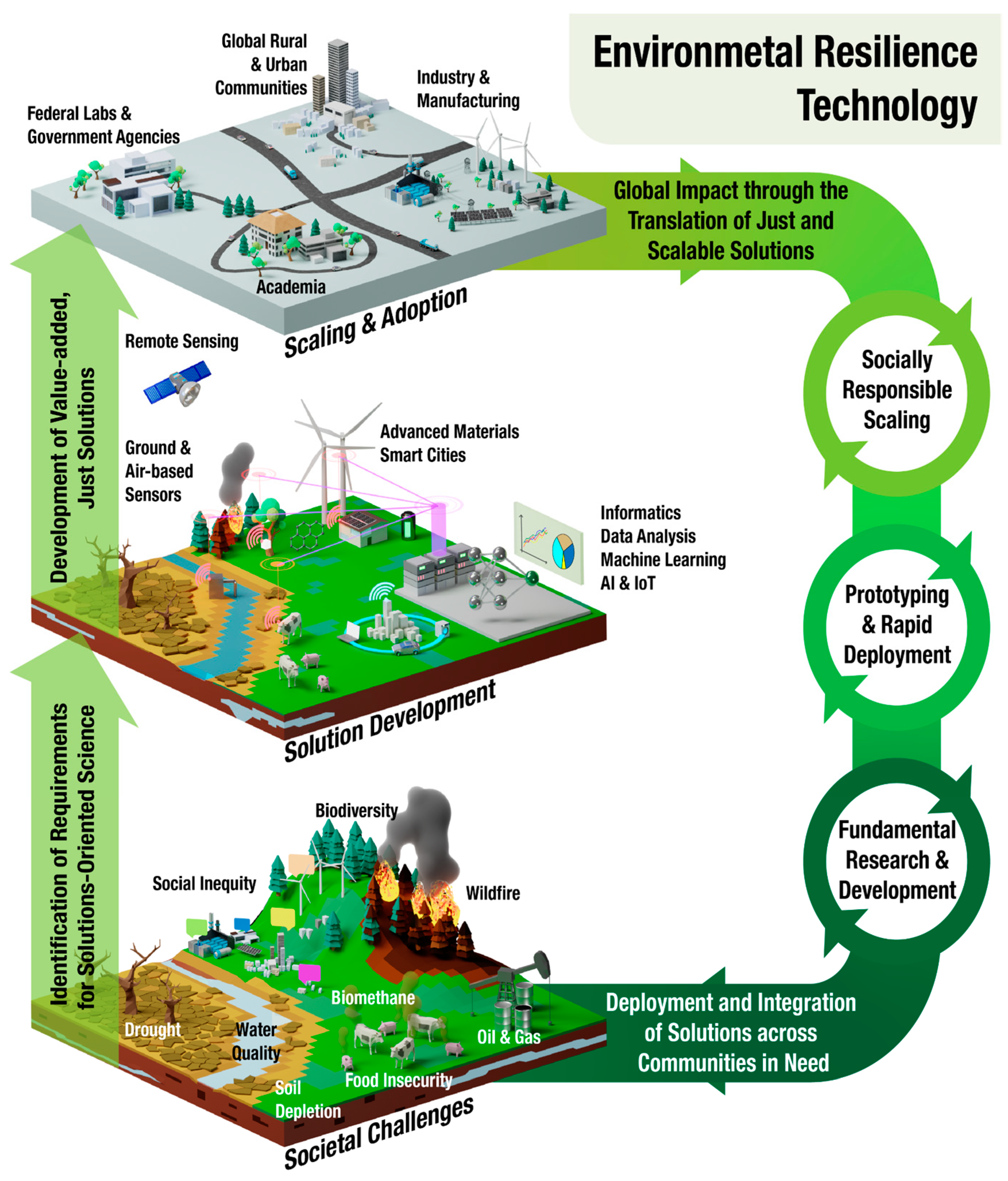
1. Introduction
Case Study Background: The Wicked Wildfire Problem in the United States
2. Methods
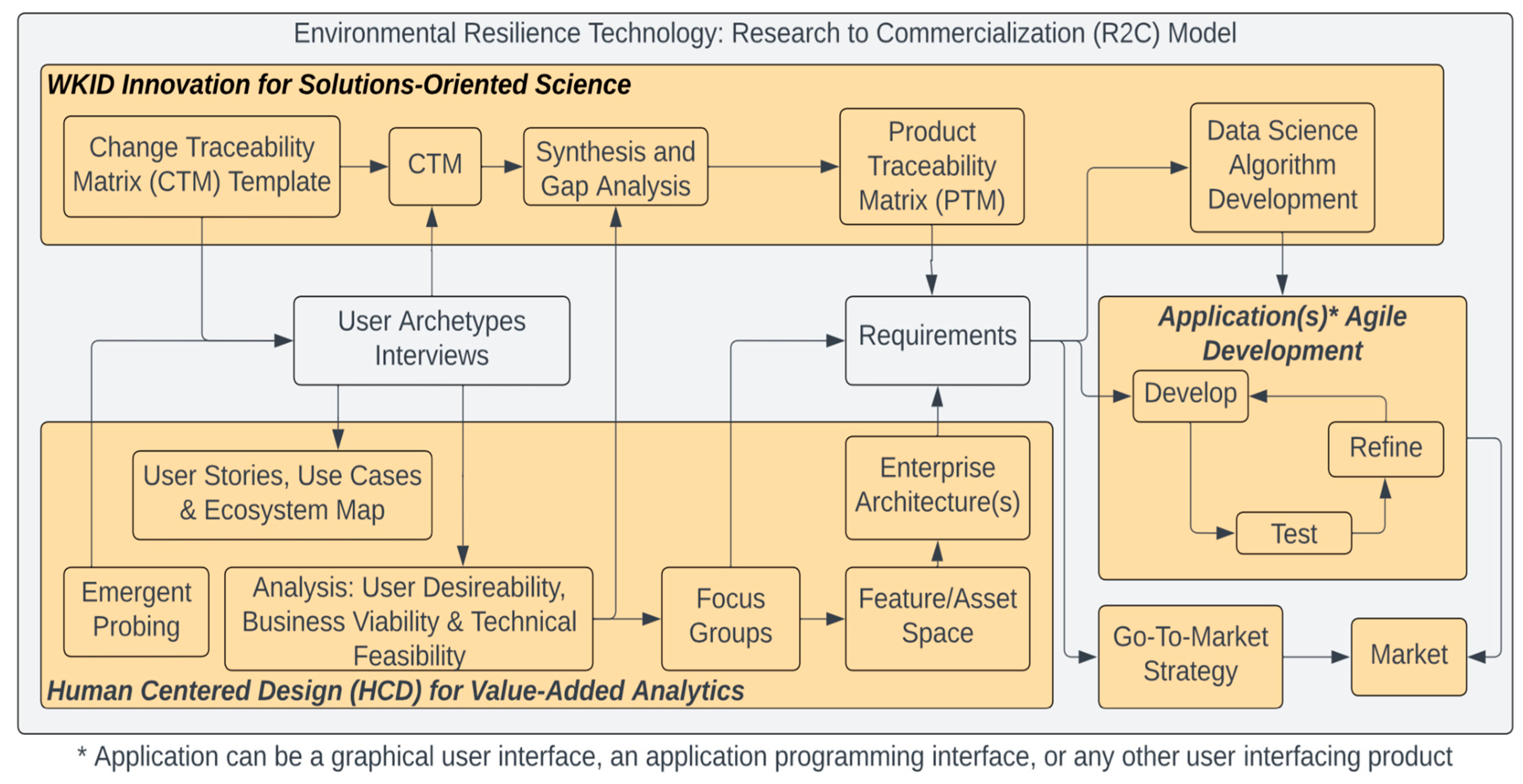
2.1. Research-to-Commercialization (R2C) Model
2.2. Case Study: Dataset Curation
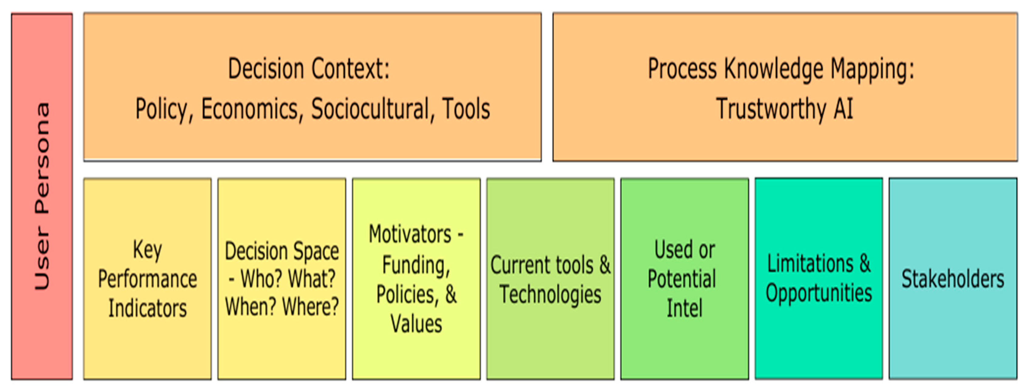
2.3. Case Study: Information Gap Analysis
2.4. Case Study: Proof-of-Concept Demonstrations
3. Results
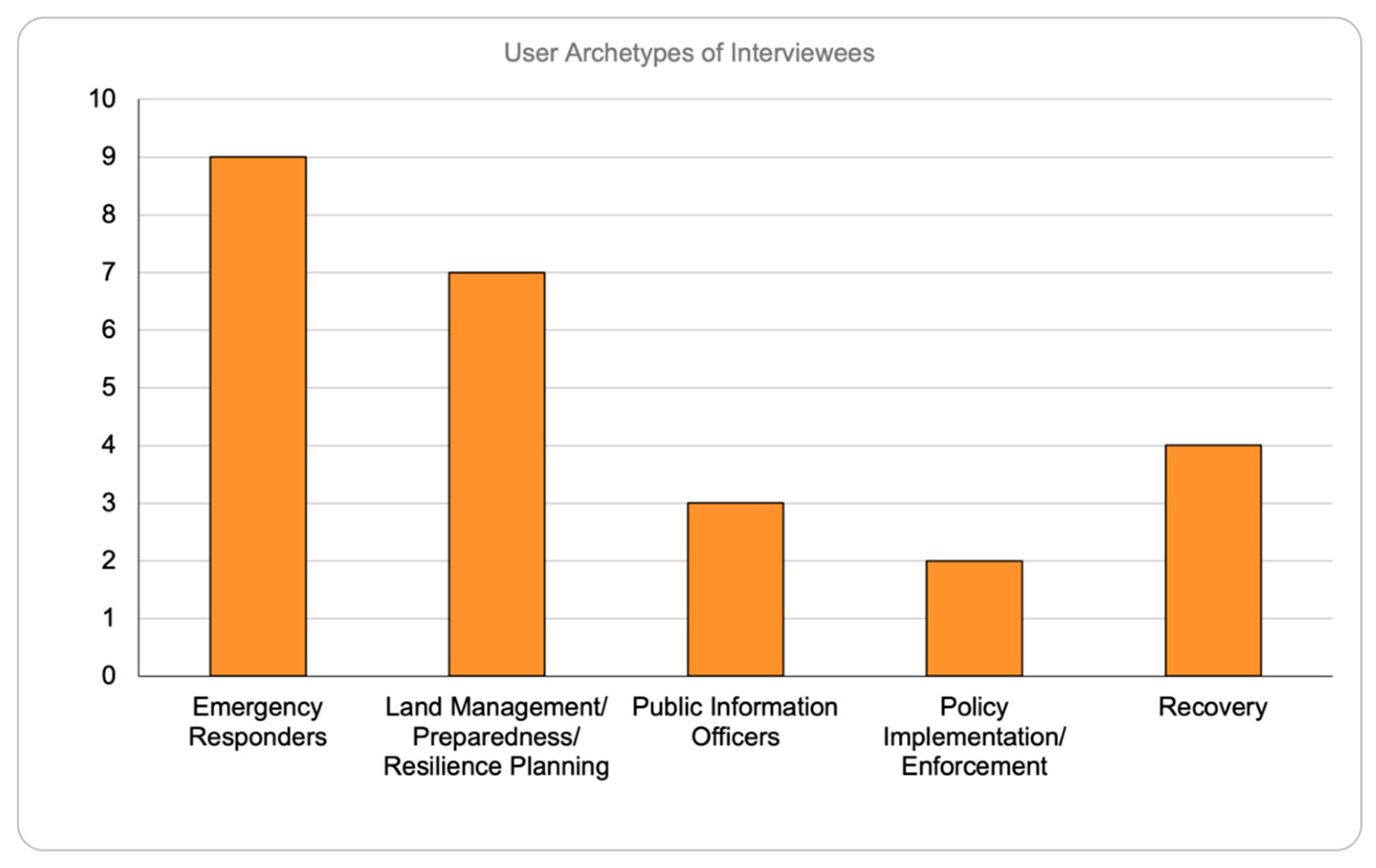
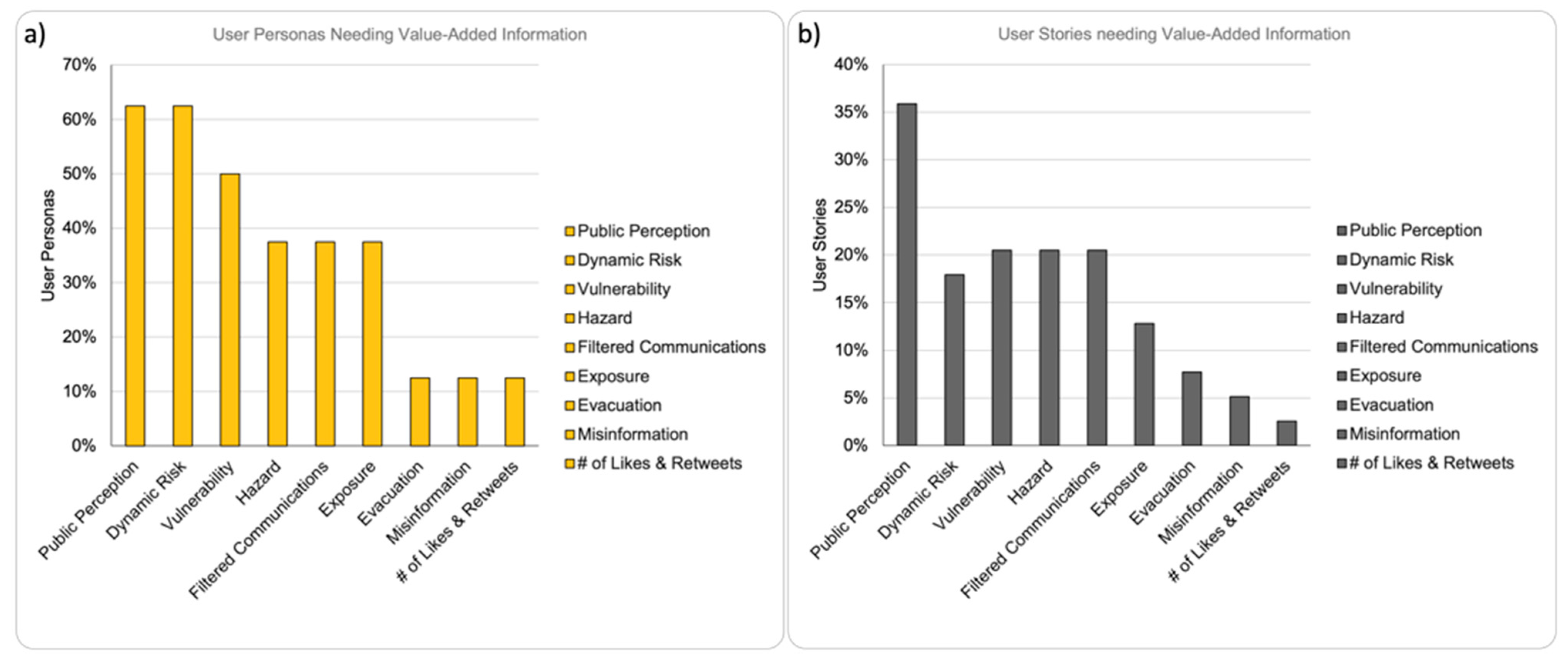
3.1. Case Study: Information Gap Analysis Results
3.2. Case Study: Proof-of-Concept Demonstration
4. Discussion
4.1. R2C Model for Co-Production of Sustainable Solutions in Environmental Resilience Technology
4.2. Case Study: Information Gap Analysis and Demonstration Discussion
5. Conclusions
Supplementary Materials
Author Contributions
Funding
Data Availability Statement
Acknowledgments
Conflicts of Interest
Appendix A. User Stories
- 1.
- Evacuation Route User Stories
- 1.1
- For protecting lives, property, and the environment, a Local Emergency Responder relies on information such as commute hours with respect to weather, time of day, distance, and fire behavior.
- 1.2
- For protecting lives, property, and the environment, a Local Emergency Responder relies on information such as Variable Sheriff/Emergency Management response time to communities in need.
- 1.3
- To effectively communicate with communities (access, e.g., 5G, language, messaging, notifications/alerts, etc.), a Local/Regional Resilience Administrator relies on information of transportation networks (who goes where and how—e.g., public transit, on what ingress/egress routes).
- 2.
- Dynamic Risk as a function of hazard, exposure and vulnerability User Stories
- 2.1
- For protecting lives, property, and the environment, a Local Emergency Responder relies on information such as dynamic risk by parcel based on fuels, weather, and home inspection information.
- 2.2
- To determine where and when to strategically position resources on the ground at the right location when needed and in response to mutual aid requisitions brokered between the public and local, state, and federal agencies, a State/Regional Emergency Responder relies on information such as dynamic current risk as it relates to anticipated short-term impacts from fire.
- 2.3
- For Disaster Declaration recommendations sent to the President that determine how much grant dollars are needed for what kind of assistance and for how long to which communities to build capability for state and local level response based on a cost–benefit analysis, a Regional Recovery Administrator relies on information of fire risk.
- 2.4
- For developing a strategic plan on what mitigation efforts to prioritize based on capability/capacity, infrastructure programs, and social justice that is often vetted with the local community through public engagement exercise and approved by city council/commissioner, a Local Land Use/Land Management/Resilience Planner relies on information of dynamic fire risk as it relates to changing fire hazard (as people cut trees, and structures are built/destroyed as combustible fuels), structural exposure, and structural vulnerability.
- 2.5
- To develop a wildfire strategy with priority high-risk areas and methods for reducing wildfire risk (fuels management—mechanical, prescribed fire, etc.) decided by rangers in each forest park and local Resilience Offices/County Commissioners and sometimes regionally (most contentious) often communicated and negotiated with the local communities, State/Regional Resilience Administrators rely on information of community Risk updated quarterly that scales from parcel to regional context (e.g., identify highest risk communities locally and regionally).
- 2.6
- To determine how many staff to hire in support of producing requested analytics by policymakers to assess capacity for meeting legislation mandates, a Resilience Planning Analytics Office relies on information of dynamic risk by parcel (60 m pixel) of assets (structures, power lines, habitat, critical infrastructure, watersheds, etc.) based on fuels, weather and home inspection information.
- 2.7
- To manage risk/reward trade-offs in a natural perils insurance portfolio by deciding whether or not to take on a risk (e.g., wildfire exposure) and what to charge for that risk based on where it sits within company tolerance for loss as it is written, the property, finance, insurance, reinsurance, and (re-)insurance companies model assets that they want to insure and send it to the underwriter who assesses the premium that can be charged for the risk, and an engineering team may visit the site and assess while offering services like mitigation advice. Underwriting then accepts/rejects risks and may initiate a process with the broker. Models are run daily on existing reinsured portfolios and monthly on the insured portfolios. This relies on information of dynamic risk (to insured losses) as asset (building) exposure and (building) vulnerability to hazard (not just today, but how it is likely to change).
- 3.
- Hazard User Stories
- 3.1
- To determine where and when to strategically position resources (contracted or in-house) on the ground at the right location when needed and in response to mutual aid requests brokered between the public and local, state and federal agencies, a state/regional emergency responder relies on information of dynamic “current” fire “risk” (i.e., hazard) as it relates to changes in fuels, topography and weather.
- 3.2
- To determine where and when to set fuel breaks (e.g., prescribe fire, hand crew, dozer, etc.) during response to active wildfire or in the “shoulder” season, a State/Regional Emergency Responder relies on information of dynamic “current” fire risk as it relates to evolving hazard of fuel condition (stress/moisture, beetles, etc.), type (veg and urban), and accumulation.
- 3.3
- To decide to defend a home or not, a Local/State/Regional Firefighter on the scene relies on information on home building materials.
- 3.4
- To determine how many staff to hire in support of producing requested analytics by policymakers to assess capacity for meeting legislation mandates, a Resilience Planning Analytics Office relies on information of national scale, including rapid, annual updates of vegetation and fuels (updated 3D layers).
- 3.5
- To manage risk/reward trade-offs in a natural perils insurance portfolio by deciding whether or not to take on a risk (e.g., wildfire exposure) and what to charge for that risk based on where it sits within company tolerance for loss as it is written, property, finance, insurance, reinsurance, and (re-)insurance companies model assets that they want to insure and send it to the underwriter who assesses the premium that can be charged for the risk, and an engineering team may visit the site and assess while offering services like mitigation advice. Underwriting then accepts/rejects risks and may initiate a process with the broker. Models are run daily on existing reinsured portfolios and monthly on the insured portfolios. This relies on information of dynamic hazards (not just today, but how it is likely to change).
- 3.6
- To develop a strategic plan on what mitigation efforts to prioritize based on capability/capacity, infrastructure programs, and social justice that is often vetted with the local community through public engagement exercise and approved by city council/commissioner, a Local Land Manager/Land Use/Resilience Planning Administrator relies on information of dynamic fire hazard (as people cut trees, and structures are built/destroyed as combustible fuels).
- 3.4
- To target communications and prepare communities about risk reduction needs and measures (e.g., evacuation routes and planning as well as home hardening), a Local/Regional/National Resilience Administrator relies on information of building locations.
- 3.8
- To develop a wildfire strategy with priority high-risk areas and methods for reducing wildfire risk (fuels management—mechanical, prescribed fire, etc.) decided by rangers in each forest park and local Resilience Offices/County Commissioners and sometimes regionally (most contentious) often communicated and negotiated with the local communities, State/Regional Resilience Administrators rely on information of fuel composition updated quarterly.
- 4.
- Vulnerability User Stories
- 4.1
- For Disaster Declarations, Regional Administrators write a recommendation to the President to determine how much grant dollars are needed for what kind of assistance and for how long to which communities to build capability for state and local-level response based on a cost–benefit analysis. To do this, a Regional Recovery Administrator relies on information of maps of the built environment (structure).
- 4.2
- To build capacity for mitigation through projects that reduce future costs (e.g., debris removal, home hardening, defensible space), State/Regional Recovery Administrators rely on information of projected maps of the built environment (structure).
- 4.3
- To determine where to focus, sheltering resources for both displaced citizens and responders, State/Regional Recovery Administrators rely on information of social vulnerability.
- 4.4
- To develop a strategic plan on what mitigation efforts to prioritize based on capability/capacity, infrastructure programs, and social justice that is often vetted with the local community through public engagement exercise and approved by the city council/commissioner, Local Land Use/Land Management/Resilient Planners rely on information on building vulnerability (ignite-ability) based on factors such as low-income housing, retrofitting, materials, etc.
- 4.5
- To develop a strategic plan on what mitigation efforts to prioritize based on capability/capacity, infrastructure programs, and social justice that is often vetted with the local community through public engagement exercise and approved by city council/commissioner, Local Land Use/Land Management/Resilient Planners rely on information of social equity.
- 4.6
- To manage risk/reward trade-offs in natural perils insurance portfolio by deciding whether or not to take on a risk (e.g., wildfire exposure) and what to charge for that risk based on where it sits within company tolerance for loss as it is written, property, finance, insurance, reinsurance, and (re-)insurance companies model assets that they want to insure and send it to the underwriter who assesses the premium that can be charged for the risk, and an engineering team may visit the site and assess while offering services like mitigation advice. Underwriting then accepts/rejects risks and may initiate a process with the broker. Models are run daily on existing reinsured portfolios and monthly on the insured portfolios. This relies on information of (building) vulnerability.
- 4.7
- To determine whether to defend a home or not, a local emergency response firefighter relies on information such as the Urban Biomass “green biomass” as a Wildland Urban Interface (WUI) layer.
- 4.8
- To support evacuation planning, a Local Resilience Administrator relies on information of social equity.
- 5.
- Exposure User Stories
- 5.1
- To determine building capacity for mitigation through projects that reduce future costs (e.g., debris removal, home hardening, defensible space), a State/Regional Recovery Administrator relies on information of projections of built environment (structure) maps.
- 5.2
- To manage risk/reward trade-offs in a natural perils insurance portfolio by deciding whether or not to take on a risk (e.g., wildfire exposure) and what to charge for that risk based on where it sits within company tolerance for loss as it is written, property, finance, insurance, reinsurance, and (re-)insurance companies model assets that they want to insure and send it to the underwriter who assesses the premium that can be charged for the risk, and an engineering team may visit the site and assess while offering services like mitigation advice. Underwriting then accepts/rejects risks and may initiate a process with the broker. Models are run daily on existing reinsured portfolios and monthly on the insured portfolios. This relies on information of dynamic asset (building) exposure.
- 5.3
- To develop a strategic plan on what mitigation efforts to prioritize based on capability/capacity, infrastructure programs, and social justice that is often vetted with the local community through public engagement exercise and approved by city council/commissioner, a Local Land Manager/Land Use/Resilience Planning Administrator relies on information of dynamic structural exposure.
- 5.4
- To develop a strategic plan on what mitigation efforts to prioritize based on capability/capacity, infrastructure programs, and social justice that is often vetted with the local community through public engagement exercise and approved by city council/commissioner, Local Land Use/Land Management/Resilient Planners rely on information of social equity.
- 5.5
- To manage risk/reward trade-offs in natural perils insurance portfolio by deciding whether or not to take on a risk (e.g., wildfire exposure) and what to charge for that risk based on where it sits within company tolerance for loss as it is written, property, finance, insurance, reinsurance, and (re-)insurance companies model assets that they want to insure and send it to the underwriter who assesses the premium that can be charged for the risk, and an engineering team may visit the site and assess while offering services like mitigation advice. Underwriting then accepts/rejects risks and may initiate a process with the broker. Models are run daily on existing reinsured portfolios and monthly on the insured portfolios. This relies on information of asset locations now and in the future.
- 6.
- Social Media Influence User Stories
- 6.1
- To influence communication strategy for effective communications with communities (access, e.g., 5G, language, messaging, notifications/alerts, etc.), a Local/State/Regional Resilience Administrator relies on information of number of likes and impressions of messaging.
- 7.
- Misinformation User Stories
- 7.1
- To decide how, when and what vetted, validated information (on community needs and situational awareness) to disseminate to the public in a timely manner and where to obtain the information, a Local/Regional Public Information Officer needs to identify point sources of misinformation and misinformation itself.
- 7.2
- To develop a strategic plan on what mitigation efforts to prioritize based on capability/capacity, infrastructure programs, and social justice that is often vetted with the local community through public engagement exercise and approved by city council/commissioner, a Local/Regional Resilience Administrator relies on information of public perception of risk and mitigation efforts with filtered misinformation.
- 8
- Filtered Communications User Stories
- 8.1
- To prioritize the 9-1-1 emergency response dispatch of consolidated resource requests (reducing calls to the right number of resource needs rather than resources/caller who may call about the same event) to the right local agency, a Local Emergency Responder relies on situational information (weapons, threats, etc.).
- 8.2
- To decide when people can return based on hazards and access to utilities (water and power), a Regional Recovery Administrator relies on information on who is evacuating and not evacuating in real time.
- 8.3
- To decide where to focus on sheltering resources for both displaced citizens and responders, a Regional Recovery Administrator relies on information of who needs resources (filtered by social media).
- 8.4
- To decide if resources spent helping on the ground are less than they would receive in consulting on recovery, a Regional Recovery consulting company relies on validated, geolocated information from reliable sources on damages (e.g., downed power lines).
- 8.5
- To decide what agency information to share publicly based on what the public needs to know to reduce the number of duplicate calls on the same incident, a Local Public Information Officer relies on information of evacuations (plans and crowdsourced feedback on available/limited resources and access).
- 8.6
- To decide how, when and what vetted, validated information (on community needs and situational awareness) to disseminate to the public in a timely manner and where to obtain the information, a Regional Public Information Officer uses information to identify the mavens (local media influencers).
- 8.7
- To build public-facing relationships around a cohesive, collaborative strategy across political boundaries for incident response, Incident Command approves staff of the National Incident Management Office (NIMO) as part of the USFS to use validated information on the local event with images, location, timestamps, and information on who took it.
- 8.8
- To determine how and when to pay out on a claim and how to reorganize capital to handle catastrophic events, a (re-)insurance company in national/international resilience planning relies on information of claim validation in the form of geolocation and photos.
- 9.
- Public Perception User Stories
- 9.1
- To protect lives, property, and the environment through response, prevention, and education made locally across departments, Local Emergency Responders coordinated across jurisdictional boundaries (“mutual aid) by the State (e.g., CAL FIRE) with federal resources allocated by Geographic Area Coordination Centers (GACC) rely on information of community perceptions of risk based on fire history and awareness.
- 9.2
- To protect lives, property, and the environment through response, prevention, and education made locally across departments, Local Emergency Responders coordinated across jurisdictional boundaries (“mutual aid) by the State (e.g., CAL FIRE) with federal resources allocated by Geographic Area Coordination Centers (GACC) rely on information of public perception with respect to rumor control of misinformation and ability to turn information into intelligence.
- 9.3
- To develop resilience plans coordinated with each community locally based on watersheds on for planning evacuation routes, infrastructure improvements, where to conduct fuel hazard reductions, and which homes to defend during active response, Local Emergency Responders rely on information of public perception with respect to rumor control of misinformation about resilience measures (e.g., prescribed fire).
- 9.4
- To prioritize the 9-1-1 emergency response dispatch of consolidated resource requests (reducing calls to the right number of resource needs, rather than resources/caller who may call about the same event) to the right local agency, Local Emergency Responders rely on information of public perception of the event.
- 9.5
- To set strategic priorities of how to use limited staff to be successful and where to prioritize investments to reduce risks (e.g., construction tailored to threats) in preparation for an upcoming wildfire season, the grant management of State/Regional Emergency Management rely on information of public perception about prioritization of protecting assets based on variable value systems.
- 9.6
- To decide where and when to strategically position resources (contracted or in-house) on the ground at the right location when needed and in response to mutual aid requests brokered between the public and local, state and federal agencies, State and Regional Emergency Managers rely on information public perception about prioritization of protecting assets based on variable value systems (e.g., timber vs. homes).
- 9.7
- To decide whether to defend a home or not, a local/state/regional firefighter relies on information of public perception about prioritization of protecting assets based on variable value systems (e.g., timber vs. homes).
- 9.8
- To decide where, when and what kind of fuel breaks to allocate (prescribe a fire, hand crew, dozer, goats, etc.) during response to active wildfire or in the “shoulder season”, local/state/regional firefighters rely on information of public perception of fuel treatments and geotagged photos of what is happening; written text needs to be verified in real time (trusted vs. not trusted).
- 9.9
- To decide when to alert and warn people of risk and how to educate the public to take mitigation action, a Local Resilience Administrator relies on information of public perception of events in real time as they happen and that is reliable from trusted sources and accurate with photos and geotagging.
- 9.10
- To develop a strategic plan on what mitigation efforts to prioritize based on capability/capacity, infrastructure programs, and social justice that is often vetted with the local community through public engagement exercise and approved by the city council/commissioner, a Local/Regional Resilience Administrator relies on information of public perception of risk and mitigation efforts with filtered misinformation.
- 9.11
- To decide how to transition from strategic planning to implementation based on priorities of the local community identified by and ranked by the city Chief Resilience Officer, a Local/Regional Resilience Administrator relies on information of public perception of risk and mitigation efforts with filtered misinformation.
- 9.12
- To communicate and prepare communities about risk reduction needs and measures (e.g., evacuation routes and planning as well as home hardening), a Local/Regional Resilience Administrator relies on information of public perception and understanding of fire risk and preparedness as well as public sentiment to determine messaging to communities of fire expectations.
- 9.13
- To influence communication strategy for effective communications with communities (access, e.g., 5G, language, messaging, notifications/alerts, etc.), a Local/State/Regional Resilience Administrator relies on information of the number of public sentiments to determine buy-in of assets being protected.
- 9.14
- To decide how, when and what vetted, validated information (on community needs and situational awareness) to disseminate to the public in a timely manner and where to obtain the information from within the constraints and scope directed by an Incident Commander, a Local/Regional Public Information Officer relies on information of public sentiment of the event.
References
- IOM. World Migration Report 2015—Migrants and Cities: New Partnerships to Manage Mobility; IOM: Grand-Saconnex, Switzerland, 2015; Volume 8, ISBN 978-92-9068-709-2. [Google Scholar]
- IPCC. Climate Change and Land: IPCC Special Report on Climate Change, Desertification, Land Degradation, Sustainable Land Management, Food Security, and Greenhouse Gas Fluxes in Terrestrial Ecosystems, 1st ed.; Cambridge University Press: Cambridge, UK, 2022; ISBN 978-1-00-915798-8. [Google Scholar]
- Barnosky, A.D.; Matzke, N.; Tomiya, S.; Wogan, G.O.U.; Swartz, B.; Quental, T.B.; Marshall, C.; McGuire, J.L.; Lindsey, E.L.; Maguire, K.C.; et al. Has the Earth’s Sixth Mass Extinction Already Arrived? Nature 2011, 471, 51–57. [Google Scholar] [CrossRef]
- Masson-Delmotte, V.; Zhai, P.; Pirani, A.; Connors, S.L.; Péan, C.; Berger, S.; Caud, N.; Chen, Y.; Goldfarb, L.; Gomis, M.I.; et al. (Eds.) Climate Change 2021: The Physical Science Basis. Contribution of Working Group I to the Sixth Assessment Report of the Intergovernmental Panel on Climate Change; Cambridge University Press: Cambridge, UK; New York, NY, USA, 2021. [Google Scholar]
- Khan, I.; Hou, F.; Le, H.P. The Impact of Natural Resources, Energy Consumption, and Population Growth on Environmental Quality: Fresh Evidence from the United States of America. Sci. Total Environ. 2021, 754, 142222. [Google Scholar] [CrossRef]
- Van Meerbeek, K.; Jucker, T.; Svenning, J.-C. Unifying the Concepts of Stability and Resilience in Ecology. J. Ecol. 2021, 109, 3114–3132. [Google Scholar] [CrossRef]
- Bohrer, G.; Cavender-Bares, J.; Chaplin-Kramer, R.; Chavez, F.; Dietze, M.; Fatoyinbo, T.; Gaddis, K.; Geller, G.; Guralnick, R.; Hestir, E.; et al. NASA Biological Diversity and Ecological Forecasting: Current State of Knowledge and Considerations for the Next Decade; NASA: Washington, DC, USA, 2022. [Google Scholar]
- IPBES. Summary for Policymakers of the Global Assessment Report on Biodiversity and Ecosystem Services. Zenodo, 2019. [Google Scholar]
- IPCC. Summary for Policymakers. In Climate Change 2022: Impacts, Adaptation and Vulnerability. Contribution of Working Group II to the Sixth Assessment Report of the Intergovernmental Panel on Climate Change; Pörtner, H.-O., Roberts, D.C., Tignor, M.M.B., Poloczanska, E.S., Mintenbeck, K., Alegría, A., Craig, M., Langsdorf, S., Löschke, S., Möller, V., et al., Eds.; Cambridge University Press: Cambridge, UK, 2022. [Google Scholar]
- NRC. Thriving on Our Changing Planet: A Decadal Strategy for Earth Observation from Space: An Overview for Decision Makers and the Public; National Academies Press: Washington, DC, USA, 2019; p. 25437. ISBN 978-0-309-49241-6. [Google Scholar]
- Diaz, J.; Denis, L.S. Classifying Twitter Users for Disaster Response: A Highly Multimodal or Simple Approach? In Proceedings of the Information Systems for Crisis Response and Management Conference (ISCRAM 2020), Blacksburg, VA, USA, 24–27 May 2020; pp. 774–789. [Google Scholar]
- Tabor, K. Achieving Multiple Conservation Goals with Satellite-Based Monitoring and Alert Systems. Ph.D. Thesis, University of Maryland, Baltimore County, MA, USA, 2023. [Google Scholar]
- Ingram, P.; Choi, Y.; Martin, R.L.; Reeves, M.; Gulati, R. Defining Your Organization’s Values. Harvard Business Review; Harvard Business Publishing: Boston, MA, USA, 2022. [Google Scholar]
- Sharp, H.; Preece, J.; Rogers, Y. Interaction Design: Beyond Human-Computer Interaction, 5th ed.; Wiley: Indianapolis, IN, USA, 2019; ISBN 978-1-119-54725-9. [Google Scholar]
- Norman, D. The Design of Everyday Things; Revised Edition; Basic Books: New York, NY, USA, 2013; ISBN 978-0-465-05065-9. [Google Scholar]
- Koberg, D.; Bagnall, J. The Universal Traveler: A Soft-Systems Guide to: Creativity, Problem-Solving, and the Process of Reaching Goals; Revised Edition; W. Kaufmann: Los Altos, CA, USA, 1974; ISBN 978-0-913232-05-7. [Google Scholar]
- Nelson, G. How to See: A Guide to Reading Our Manmade Environment; Little, Brown and Company: Boston, MA, USA, 1979; ISBN 978-0-316-60312-6. [Google Scholar]
- McKim, R.H. Experiences in Visual Thinking, 2nd ed.; Cengage Learning: Monterey, CA, USA, 1980; ISBN 978-0-8185-0411-2. [Google Scholar]
- Thomas, V.; Remy, C.; Bates, O. The Limits of HCD: Reimagining the Anthropocentricity of ISO 9241-210. In Proceedings of the 2017 Workshop on Computing within Limits; Association for Computing Machinery, New York, NY, USA, 22 June 2017; pp. 85–92. [Google Scholar]
- Van Velsen, L.; Ludden, G.; Grünloh, C. The Limitations of User-and Human-Centered Design in an EHealth Context and How to Move Beyond Them. J. Med. Internet Res. 2022, 24, e37341. [Google Scholar] [CrossRef]
- Vlaskovits, P. Henry Ford, Innovation, and That “Faster Horse” Quote. Harvard Business Review; Harvard Business Publishing: Boston, MA, USA, 2011. [Google Scholar]
- Tanweer, A.; Aragon, C.R.; Muller, M.; Guha, S.; Passi, S.; Neff, G.; Kogan, M. Interrogating Human-Centered Data Science: Taking Stock of Opportunities and Limitations. In Proceedings of the Extended Abstracts of the 2022 CHI Conference on Human Factors in Computing Systems; Association for Computing Machinery, New York, NY, USA, 28 April 2022; pp. 1–6. [Google Scholar]
- Rittel, H.W.J.; Webber, M.M. Dilemmas in a General Theory of Planning. Policy Sci. 1973, 4, 155–169. [Google Scholar] [CrossRef]
- Kennedy, M.C.; Ford, E.D.; Singleton, P.; Finney, M.; Agee, J.K. Informed Multi-Objective Decision-Making in Environmental Management Using Pareto Optimality. J. Appl. Ecol. 2008, 45, 181–192. [Google Scholar] [CrossRef]
- Stavros, E.N. Wicked Problems Need WKID Innovation. Res.-Technol. Manag. 2022, 65, 39–47. [Google Scholar] [CrossRef]
- Ackoff, R. From Data to Wisdom. J. Appl. Syst. Anal. 1989, 16, 3–9. [Google Scholar]
- Aguilar, F.J. Scanning the Business Environment; Macmillan Publishers Limited: New York, NY, USA, 1967. [Google Scholar]
- NASA. NASA Systems Engineering Handbook; NASA SP-2016-6105; NASA: Washington, DC, USA, 2007. [Google Scholar]
- Taplin, D.H.; Clark, H.; Collins, E.; Colby, D.C. Theory of Change; ActKnowledge: New York, NY, USA, 2003. [Google Scholar]
- Iglesias, V.; Stavros, N.; Balch, J.K.; Barrett, K.; Cobian-Iñiguez, J.; Hester, C.; Kolden, C.A.; Leyk, S.; Nagy, R.C.; Reid, C.E.; et al. Fires That Matter: Reconceptualizing Fire Risk to Include Interactions between Humans and the Natural Environment. Environ. Res. Lett. 2022, 17, 045014. [Google Scholar] [CrossRef]
- Jerrett, M.; Jina, A.S.; Marlier, M.E. Up in Smoke: California’s Greenhouse Gas Reductions Could Be Wiped out by 2020 Wildfires. Environ. Pollut. 2022, 310, 119888. [Google Scholar] [CrossRef]
- Balch, J.K.; Bradley, B.A.; Abatzoglou, J.T.; Nagy, R.C.; Fusco, E.J.; Mahood, A.L. Human-Started Wildfires Expand the Fire Niche across the United States. Proc. Natl. Acad. Sci. USA 2017, 114, 2946–2951. [Google Scholar] [CrossRef]
- Mietkiewicz, N.; Balch, J.K.; Schoennagel, T.; Leyk, S.; St. Denis, L.A.; Bradley, B.A. In the Line of Fire: Consequences of Human-Ignited Wildfires to Homes in the U.S. (1992–2015). Fire 2020, 3, 50. [Google Scholar] [CrossRef]
- Moritz, M.A.; Morais, M.E.; Summerell, L.A.; Carlson, J.M.; Doyle, J. Wildfires, Complexity, and Highly Optimized Tolerance. Proc. Natl. Acad. Sci. USA 2005, 102, 17912–17917. [Google Scholar] [CrossRef] [PubMed]
- Jolly, W.M.; Cochrane, M.A.; Freeborn, P.H.; Holden, Z.A.; Brown, T.J.; Williamson, G.J.; Bowman, D.M.J.S. Climate-Induced Variations in Global Wildfire Danger from 1979 to 2013. Nat. Commun. 2015, 6, 7537. [Google Scholar] [CrossRef] [PubMed]
- Stavros, E.N.; Abatzoglou, J.T.; McKenzie, D.; Larkin, N.K. Regional Projections of the Likelihood of Very Large Wildland Fires under a Changing Climate in the Contiguous Western United States. Clim. Chang. 2014, 126, 455–468. [Google Scholar] [CrossRef]
- Barbero, R.; Abatzoglou, J.T.; Larkin, N.K.; Kolden, C.A.; Stocks, B. Climate Change Presents Increased Potential for Very Large Fires in the Contiguous United States. Int. J. Wildland Fire 2015, 24, 892. [Google Scholar] [CrossRef]
- Iglesias, V.; Balch, J.K.; Travis, W.R. U.S. Fires Became Larger, More Frequent, and More Widespread in the 2000s. Sci. Adv. 2022, 8, eabc0020. [Google Scholar] [CrossRef]
- Abatzoglou, J.T.; Battisti, D.S.; Williams, A.P.; Hansen, W.D.; Harvey, B.J.; Kolden, C.A. Projected Increases in Western US Forest Fire despite Growing Fuel Constraints. Commun. Earth Environ. 2021, 2, 227. [Google Scholar] [CrossRef]
- Kolden, C.A. We’re Not Doing Enough Prescribed Fire in the Western United States to Mitigate Wildfire Risk. Fire 2019, 2, 30. [Google Scholar] [CrossRef]
- Coen, J.L.; Stavros, E.N.; Fites-Kaufman, J.A. Deconstructing the King Megafire. Ecol. Appl. 2018, 28, 1565–1580. [Google Scholar] [CrossRef]
- Pascolini-Campbell, M.; Lee, C.; Stavros, N.; Fisher, J.B. ECOSTRESS Reveals Pre-Fire Vegetation Controls on Burn Severity for Southern California Wildfires of 2020. Glob. Ecol. Biogeogr. 2022, 31, 1976–1989. [Google Scholar] [CrossRef]
- Iglesias, V.; Braswell, A.E.; Rossi, M.W.; Joseph, M.B.; McShane, C.; Cattau, M.; Koontz, M.J.; McGlinchy, J.; Nagy, R.C.; Balch, J.; et al. Risky Development: Increasing Exposure to Natural Hazards in the United States. Earths Future 2021, 9, e2020EF001795. [Google Scholar] [CrossRef]
- Higuera, P.E.; Cook, M.C.; Balch, J.K.; Stavros, E.N.; Mahood, A.L.; St. Denis, L.A. Shifting Social-Ecological Fire Regimes Explain Increasing Structure Loss from Western Wildfires. PNAS Nexus 2023, 2, pgad005. [Google Scholar] [CrossRef] [PubMed]
- Vilà, M.; Ibáñez, I. Plant Invasions in the Landscape. Landsc. Ecol. 2011, 26, 461–472. [Google Scholar] [CrossRef]
- Mosher, E.S.; Silander, J.A.; Latimer, A.M. The Role of Land-Use History in Major Invasions by Woody Plant Species in the Northeastern North American Landscape. Biol. Invasions 2009, 11, 2317. [Google Scholar] [CrossRef]
- Abatzoglou, J.T.; Kolden, C.A. Relationships between Climate and Macroscale Area Burned in the Western United States. Int. J. Wildland Fire 2013, 22, 1003. [Google Scholar] [CrossRef]
- Stavros, E.N.; Iglesias, V.; Decastro, A. The Wicked Wildfire Problem and Solution Space for Detecting and Tracking the Fires That Matter. Available online: http://www.essoar.org/doi/10.1002/essoar.10506888.1 (accessed on 7 June 2021).
- Nagji, B.; Tuff, G. Managing Your Innovation Portfolio, Harvard Business Review; Harvard Business Publishing: Boston, MA, USA, 2012. [Google Scholar]
- NIST. Trustworthy and Responsible AI; NIST: Gaithersburg, MD, USA, 2022. [Google Scholar]
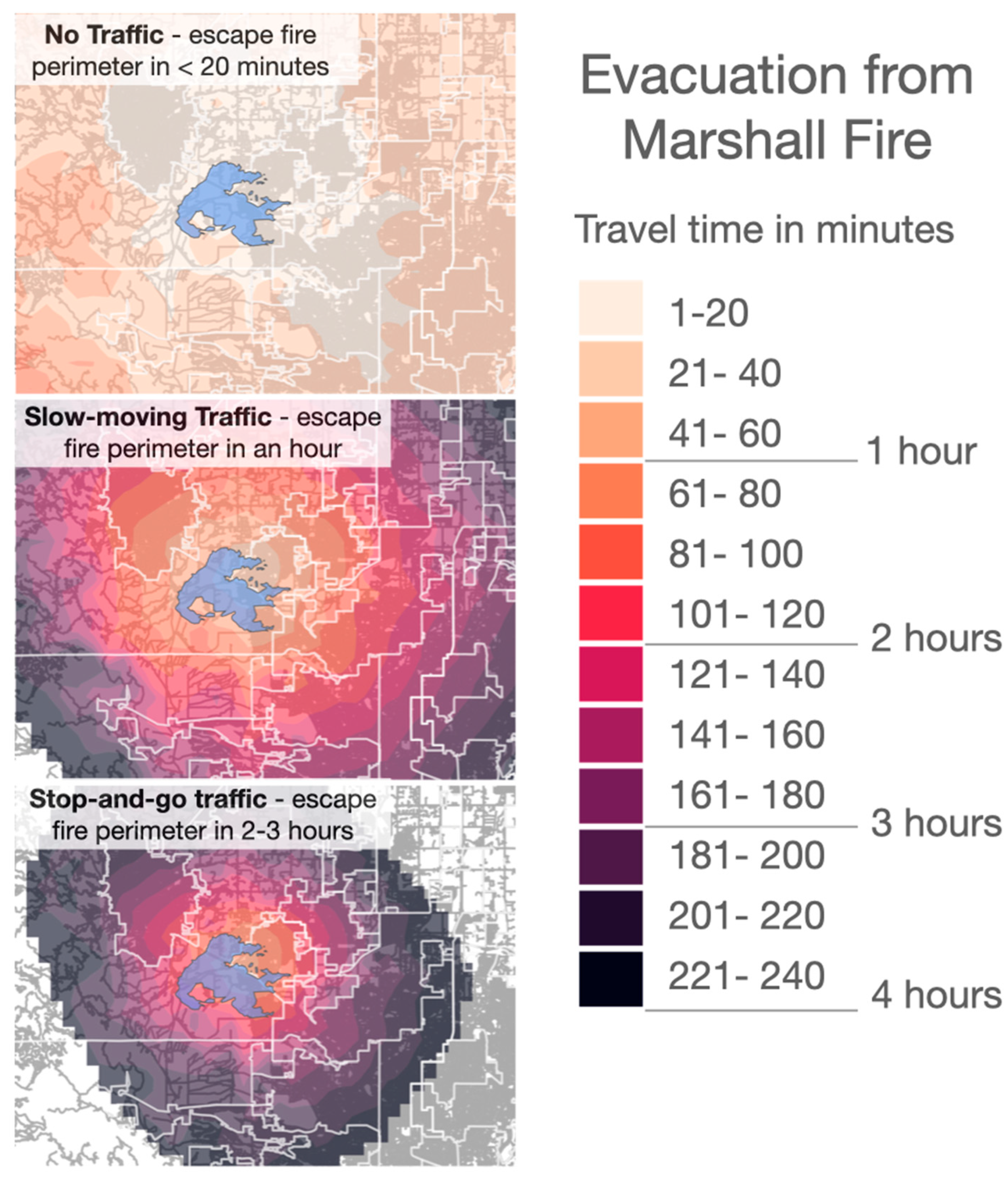
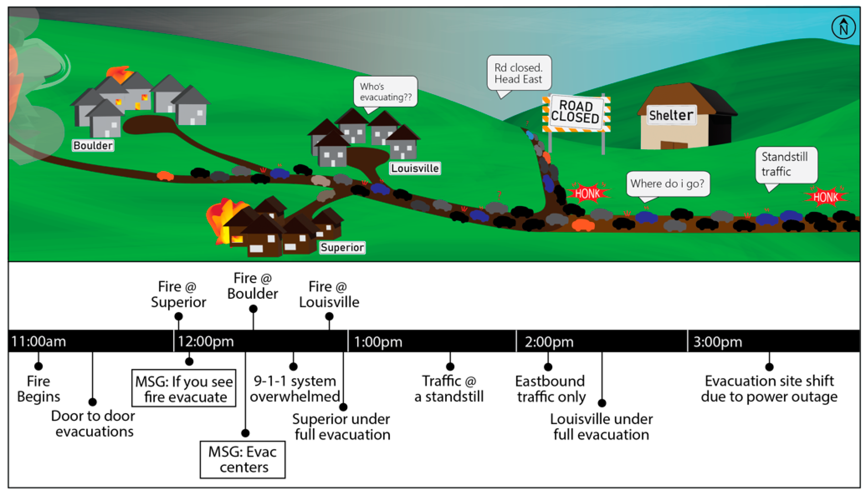
- Fovell, R.G.; Brewer, M.J.; Garmong, R.J. The December 2021 Marshall Fire: Predictability and Gust Forecasts from Operational Models. Atmosphere 2022, 13, 765. [Google Scholar] [CrossRef]
- Twitter Inc. Twitter API V2 2023. Available online: https://developer.twitter.com/en/docs/api-reference-index (accessed on 8 September 2023).
- St. Denis, L.A.; Hughes, A.L. ‘What I Need to Know Is What I Don’t Know!’: Filtering Disaster Twitter Data for Information from Local Individuals. In Proceedings of the 17th ISCRAM Conference, Blacksburg, VA, USA, 24–27 May 2020; Hughes, A.L., McNeill, F., Zobel, C., Eds.; [Google Scholar]
- St Denis, L. Social Media Content Filtering for Emergency. Management. Patent Pending Application 18/000,314.
- Pereira, R.H.M.; Saraiva, M.; Herszenhut, D.; Braga, C.K.V.; Conway, M.W. R5r: Rapid Realistic Routing on Multimodal Transport Networks with R5 in R. Findings 2021. [Google Scholar] [CrossRef]
- NIFC. NIFC Open Data Site: Federal Interagency Wildland Fire Maps and Data for All 2018; NIFC: Boise, ID, USA, 2018. [Google Scholar]
- Zillow Inc. ZTRAX: Zillow Transaction and Assessment Dataset 2016; Zillow: Seattle, WA, USA, 2016. [Google Scholar]
- Joseph, M.B.; Rossi, M.W.; Mietkiewicz, N.P.; Mahood, A.L.; Cattau, M.E.; St. Denis, L.A.; Nagy, R.C.; Iglesias, V.; Abatzoglou, J.T.; Balch, J.K. Spatiotemporal Prediction of Wildfire Size Extremes with Bayesian Finite Sample Maxima. Ecol. Appl. 2019, 29, e01898. [Google Scholar] [CrossRef]
- Zhang, H.; Song, M.; He, H. Achieving the Success of Sustainability Development Projects through Big Data Analytics and Artificial Intelligence Capability. Sustainability 2020, 12, 949. [Google Scholar] [CrossRef]
- Harfouche, A.L.; Jacobson, D.A.; Kainer, D.; Romero, J.C.; Harfouche, A.H.; Scarascia Mugnozza, G.; Moshelion, M.; Tuskan, G.A.; Keurentjes, J.J.B.; Altman, A. Accelerating Climate Resilient Plant Breeding by Applying Next-Generation Artificial Intelligence. Trends Biotechnol. 2019, 37, 1217–1235. [Google Scholar] [CrossRef] [PubMed]
- Jung, J.; Maeda, M.; Chang, A.; Bhandari, M.; Ashapure, A.; Landivar-Bowles, J. The Potential of Remote Sensing and Artificial Intelligence as Tools to Improve the Resilience of Agriculture Production Systems. Curr. Opin. Biotechnol. 2021, 70, 15–22. [Google Scholar] [CrossRef]
- NSF Directorate for Technology, Innovation and Partnerships (TIP) Resources and Contracts. Available online: https://beta.nsf.gov/tip/resources (accessed on 29 March 2023).
- Ramirez, J. California 2020: Worst Fire Season Ever, Again. Now What? An Effort to Dissect the California Fire Quilt; International Association of Wildland Fire: Missoula, Montana, USA, 2021; Available online: https://www.iawfonline.org/article/california-2020-worst-fire-season-ever-again-now-what-an-effort-to-dissect-the-california-fire-quilt/ (accessed on 29 March 2023).
- NRC. Accelerating Technology Transi-Tion: Bridging the Valley of Death for Materials and Processes in Defense Systems; National Academies Press: Washington, DC, USA, 2004. [Google Scholar]
- NASA. The Application Readiness Level Metric; NASA Applied Sciences: Washington, DC, USA, 2019. [Google Scholar]
- Hallett, L.M.; Morelli, T.L.; Gerber, L.R.; Moritz, M.A.; Schwartz, M.W.; Stephenson, N.L.; Tank, J.L.; Williamson, M.A.; Woodhouse, C.A. Navigating Translational Ecology: Creating Opportunities for Scientist Participation. Front. Ecol. Environ. 2017, 15, 578–586. [Google Scholar] [CrossRef]
- Markman, G.D.; Siegel, D.S.; Wright, M. Research and Technology Commercialization. J. Manag. Stud. 2008, 45, 1401–1423. [Google Scholar] [CrossRef]
- Polk, M. Transdisciplinary Co-Production: Designing and Testing a Transdisciplinary Research Framework for Societal Problem Solving. Futures 2015, 65, 110–122. [Google Scholar] [CrossRef]
- Hawkins, J.; Madden, K.; Fletcher, A.; Midgley, L.; Grant, A.; Cox, G.; Moore, L.; Campbell, R.; Murphy, S.; Bonell, C.; et al. Development of a Framework for the Co-Production and Prototyping of Public Health Interventions. BMC Public Health 2017, 17, 689. [Google Scholar] [CrossRef]
- Schlesinger, W.H. Translational Ecology. Science 2010, 329, 609. [Google Scholar] [CrossRef]
- Enquist, C.A.; Jackson, S.T.; Garfin, G.M.; Davis, F.W.; Gerber, L.R.; Littell, J.A.; Tank, J.L.; Terando, A.J.; Wall, T.U.; Halpern, B.; et al. Foundations of Translational Ecology. Front. Ecol. Environ. 2017, 15, 541–550. [Google Scholar] [CrossRef]
- Bovaird, T. Beyond Engagement and Participation: User and Community Coproduction of Public Services. Public Adm. Rev. 2007, 67, 846–860. [Google Scholar] [CrossRef]
- Brandsen, T.; Honingh, M. Distinguishing Different Types of Coproduction: A Conceptual Analysis Based on the Classical Definitions. Public Adm. Rev. 2016, 76, 427–435. [Google Scholar] [CrossRef]
- Schwartz, M.W.; Hiers, J.K.; Davis, F.W.; Garfin, G.M.; Jackson, S.T.; Terando, A.J.; Woodhouse, C.A.; Morelli, T.L.; Williamson, M.A.; Brunson, M.W. Developing a Translational Ecology Workforce. Front. Ecol. Environ. 2017, 15, 587–596. [Google Scholar] [CrossRef]
- Gwyn, C.W.; Silverman, P.J. EUVL: Transition from Research to Commercialization. Photomask and Next-Generation Lithography Mask Technology X, 28 August 2003; SPIE: Bellingham, WA, USA, 2003; Volume 5130, pp. 990–1004. [Google Scholar] [CrossRef]
- Wouters, O.J.; McKee, M.; Luyten, J. Estimated Research and Development Investment Needed to Bring a New Medicine to Market, 2009–2018. JAMA 2020, 323, 844–853. [Google Scholar] [CrossRef]
- Buyya, R. Market-Oriented Cloud Computing: Vision, Hype, and Reality of Delivering Computing as the 5th Utility. In Proceedings of the 2009 Fourth ChinaGrid Annual Conference, Yantai, China, 21–22 August 2009; pp. xii–xv. [Google Scholar]
- Stoeklé, H.-C.; Mamzer-Bruneel, M.-F.; Vogt, G.; Hervé, C. 23andMe: A New Two-Sided Data-Banking Market Model. BMC Med. Ethics 2016, 17, 19. [Google Scholar] [CrossRef] [PubMed]
- Duchelle, A.E.; Simonet, G.; Sunderlin, W.D.; Wunder, S. What Is REDD+ Achieving on the Ground? Curr. Opin. Environ. Sustain. 2018, 32, 134–140. [Google Scholar] [CrossRef]
- Thomas, E.; Ntazinda, J.; Kathuni, S. Applying Climate Reparative Finance toward Water Security. Sci. Total Environ. 2023, 875, 162506. [Google Scholar] [CrossRef] [PubMed]
- Bryson, J.M.; Crosby, B.C.; Stone, M.M. The Design and Implementation of Cross-Sector Collaborations: Propositions from the Literature. Public Adm. Rev. 2006, 66, 44–55. [Google Scholar] [CrossRef]
- Florin, U.; Lindhult, E. Norms and Ethics: Prerequisites for Excellence in Co-Production. In Proceedings of the Högskola och Samhälle i Samverkan HSS´, 15, Kalmar, Sweden, 28 May 2015. [Google Scholar]
- Page, K. Ethics and the Co-Production of Knowledge. Public Health Res. Pract. 2022, 32, 3222213. [Google Scholar] [CrossRef]
- Vicente-Saez, R.; Martinez-Fuentes, C. Open Science Now: A Systematic Literature Review for an Integrated Definition. J. Bus. Res. 2018, 88, 428–436. [Google Scholar] [CrossRef]
- Mikhaylov, S.J.; Esteve, M.; Campion, A. Artificial Intelligence for the Public Sector: Opportunities and Challenges of Cross-Sector Collaboration. Philos. Trans. R. Soc. Math. Phys. Eng. Sci. 2018, 376, 20170357. [Google Scholar] [CrossRef]
- Wilkinson, M.D.; Dumontier, M.; Aalbersberg, I.J.; Appleton, G.; Axton, M.; Baak, A.; Blomberg, N.; Boiten, J.-W.; da Silva Santos, L.B.; Bourne, P.E.; et al. The FAIR Guiding Principles for Scientific Data Management and Stewardship. Sci. Data 2016, 3, 160018. [Google Scholar] [CrossRef]
- Carroll, S.R.; Garba, I.; Figueroa-Rodriguez, O.L.; Halbrook, J.; Raseroka, K.; Rodriguez-Lonebear, D.; Rowe, R.; Rodrigo, S.; Walker, J.D.; Anderson, J.; et al. The CARE Principles for Indigenous Data Governance. Available online: https://datascience.codata.org/articles/10.5334/dsj-2020-043/ (accessed on 20 April 2021).
- Rasmussen, E.; Moen, Ø.; Gulbrandsen, M. Initiatives to Promote Commercialization of University Knowledge. Technovation 2006, 26, 518–533. [Google Scholar] [CrossRef]
- Bryson, J.M.; Crosby, B.C.; Stone, M.M. Designing and Implementing Cross-Sector Collaborations: Needed and Challenging. Public Adm. Rev. 2015, 75, 647–663. [Google Scholar] [CrossRef]
- Mahmoud, H.; Chulahwat, A. Assessing Wildland–Urban Interface Fire Risk. R. Soc. Open Sci. 2020, 7, 201183. [Google Scholar] [CrossRef] [PubMed]
- Mann, M.L.; Berck, P.; Moritz, M.A.; Batllori, E.; Baldwin, J.G.; Gately, C.K.; Cameron, D.R. Modeling Residential Development in California from 2000 to 2050: Integrating Wildfire Risk, Wildland and Agricultural Encroachment. Land Use Policy 2014, 41, 438–452. [Google Scholar] [CrossRef]
- Quarles, S.L.; Pohl, K. Building a Wildfire-Resistant Home: Codes and Costs; Headwaters Economics: Bozeman, Montana, 2018. [Google Scholar]
- Chulahwat, A.; Mahmoud, H.; Monedero, S.; Diez Vizcaíno, F.J.; Ramirez, J.; Buckley, D.; Forradellas, A.C. Integrated Graph Measures Reveal Survival Likelihood for Buildings in Wildfire Events. Sci. Rep. 2022, 12, 15954. [Google Scholar] [CrossRef]
- Ribeiro, S.S., Jr.; Davis, C.A., Jr.; Oliveira, D.R.R.; Meira, W., Jr.; Gonçalves, T.S.; Pappa, G.L. Traffic Observatory: A System to Detect and Locate Traffic Events and Conditions Using Twitter. In Proceedings of the 5th ACM SIGSPATIAL International Workshop on Location-Based Social Networks, Redondo Beach, CA, USA, 6 November 2012. [Google Scholar]
- Kotzias, D.; Lappas, T.; Gunopulos, D. Home Is Where Your Friends Are: Utilizing the Social Graph to Locate Twitter Users in a City. Inf. Syst. 2016, 57, 77–87. [Google Scholar] [CrossRef]
- Cheng, Z.; Caverlee, J.; Lee, K. You Are Where You Tweet: A Content-Based Approach to Geo-Locating Twitter Users. In Proceedings of the 19th ACM International Conference on Information and Knowledge Management, Toronto, ON, Canada, 26–30 October 2010; Association for Computing Machinery: New York, NY, USA, 2010; pp. 759–768. [Google Scholar]
- Islam, M.R.; Liu, S.; Wang, X.; Xu, G. Deep Learning for Misinformation Detection on Online Social Networks: A Survey and New Perspectives. Soc. Netw. Anal. Min. 2020, 10, 82. [Google Scholar] [CrossRef]


| Type of Limitation or Opportunity | # of User Personas | Requirement Consolidated Across Personas |
|---|---|---|
| Social Media | 5 | Social media information shall include filters by: “deep fakes”, misinformation, bots, verified accounts, etc. |
| Risk Futures | 5 | Risk futures that project risk, as defined by how it is messaged rather than just acres burned, under different management scenarios to link cost of management to risk mitigation benefit. |
| Risk General | 3 | Risk information shall provide uncertainty by each layer: hazard, exposure, vulnerability. |
| Risk information should consider scalability beyond data limitations of the United States. | ||
| Risk information shall include more than simple maps of the Wildland Urban Interface. | ||
| Hazard | 2 | Hazard information shall provide fuel maps that are updated frequently as fuels change. |
| Vulnerability | 2 | Vulnerability information shall include building ignition potential today and into the future. |
| Incident Reporting | 2 | Incident information shall automatically populate based on curated data from different data sources. |
| Exposure | 1 | Exposure information shall include building locations today and likely locations into the future. |
| General | 1 | Information technologies shall focus on proactive solutions rather than only reactive solutions (i.e., suppression). |
| 1 | Information of value shall include metadata. | |
| 1 | Impact information shall link building damage to insurance policies. | |
| 1 | Information of value shall be verified with local knowledge. | |
| 1 | Information of value shall provide the granularity needed to inform decisions. | |
| 1 | Information technologies shall enable analytics (e.g., trend analyses). |
| Type of Limitation or Opportunity | # of User Personas | Requirement Consolidated Across Personas |
|---|---|---|
| Product Definition | 7 | Information technology shall be interoperable to “plug in” to existing data portals used by User Personas to reduce the number of sources/screens that they must visit and enable them to use existing data layers. |
| 1 | Data platforms should plug into a single existing government data portal when one becomes available by the federal government. | |
| User Experience (UX) | 5 | Information layers shall be intuitive to interpret to reduce training for use. |
| Accessibility | 6 | Information technologies shall be accessible via a cell phone or government laptop with limited connectivity. |
| 1 | Information layers shall be accessible via both information technologies and print outs. | |
| 1 | Information layers shall be archivable with provenance to be public record. | |
| Business Model | 5 | Information technologies shall meet the objectives of federal funding sources while also servicing local and state decision needs. |
| Trustworthy AI | 4 | Information for value-added analytics shall have transparent documentation of algorithms. |
| Information for value-added analytics shall be open source. | ||
| Information for value-added analytics shall include uncertainty and error propagation. | ||
| Product Requirements | 5 | Information for value-added analytics shall be archived for long-term access. |
| Information for value-added analytics shall be pre-processed and ready to use. | ||
| Information for value-added analytics shall incentivize more resilient behavior and penalize less resilient behavior. | ||
| Information technologies shall integrate cybersecurity. | ||
| Information technologies should be marketed to the relevant agencies for using the available information. | ||
| Other Technology and Cultural Needs | 1 | Information technologies should include a business model to better serve less advantaged communities without exploiting them. |
Disclaimer/Publisher’s Note: The statements, opinions and data contained in all publications are solely those of the individual author(s) and contributor(s) and not of MDPI and/or the editor(s). MDPI and/or the editor(s) disclaim responsibility for any injury to people or property resulting from any ideas, methods, instructions or products referred to in the content. |
© 2023 by the authors. Licensee MDPI, Basel, Switzerland. This article is an open access article distributed under the terms and conditions of the Creative Commons Attribution (CC BY) license (https://creativecommons.org/licenses/by/4.0/).
Share and Cite
Stavros, E.N.; Gezon, C.; St. Denis, L.; Iglesias, V.; Zapata, C.; Byrne, M.; Cooper, L.; Cook, M.; Doyle, E.; Stephens, J.; et al. Environmental Resilience Technology: Sustainable Solutions Using Value-Added Analytics in a Changing World. Appl. Sci. 2023, 13, 11034. https://doi.org/10.3390/app131911034
Stavros EN, Gezon C, St. Denis L, Iglesias V, Zapata C, Byrne M, Cooper L, Cook M, Doyle E, Stephens J, et al. Environmental Resilience Technology: Sustainable Solutions Using Value-Added Analytics in a Changing World. Applied Sciences. 2023; 13(19):11034. https://doi.org/10.3390/app131911034
Chicago/Turabian StyleStavros, E. Natasha, Caroline Gezon, Lise St. Denis, Virginia Iglesias, Christina Zapata, Michael Byrne, Laurel Cooper, Maxwell Cook, Ethan Doyle, Jilmarie Stephens, and et al. 2023. "Environmental Resilience Technology: Sustainable Solutions Using Value-Added Analytics in a Changing World" Applied Sciences 13, no. 19: 11034. https://doi.org/10.3390/app131911034