Letter

Global Airborne Laser Scanning Data Providers Database (GlobALS)—A New Tool for Monitoring Ecosystems and Biodiversity

1
Department of Geomatics, Forest Research Institute, 05-090 Raszyn, Poland
2
DIBAF—Forest Ecology Lab, Tuscia University, 01100 Viterbo, Italy
3
Geolab—Laboratory of Forest Geomatics, Department of Agriculture, Food, Environment and Forestry, Università degli Studi di Firenze, 50145 Firenze, Italy
4
Department of Plants Sciences, University of Cambridge Conservation Research Institute, Cambridge CB2 3QZ, UK
5
Department of Sustainable Agro-Ecosystems and Bioresources, Research and Innovation Centre, Fondazione Edmund Mach, 38010 San Michele all’Adige, Italy
6
Faculty of Geodesy and Geomatics Engineering, K.N. Toosi University of Technology, 19967-15433 Tehran, Iran
7
Department of Remote Sensing, University of Würzburg, 97074 Würzburg, Germany
8
Consiglio per la Ricerca in Agricoltura e l’analisi dell’economia Agraria, Research Centre for Forestry and Wood, 52100 Arezzo, Italy
*
Author to whom correspondence should be addressed.
Remote Sens. 2020, 12(11), 1877; https://doi.org/10.3390/rs12111877
Submission received: 14 April 2020 / Revised: 2 June 2020 / Accepted: 5 June 2020 / Published: 9 June 2020
(This article belongs to the Special Issue Remote Sensing for Biodiversity Mapping and Monitoring)

Abstract

:
Protection and recovery of natural resource and biodiversity requires accurate monitoring at multiple scales. Airborne Laser Scanning (ALS) provides high-resolution imagery that is valuable for monitoring structural changes to vegetation, providing a reliable reference for ecological analyses and comparison purposes, especially if used in conjunction with other remote-sensing and field products. However, the potential of ALS data has not been fully exploited, due to limits in data availability and validation. To bridge this gap, the global network for airborne laser scanner data (GlobALS) has been established as a worldwide network of ALS data providers that aims at linking those interested in research and applications related to natural resources and biodiversity monitoring. The network does not collect data itself but collects metadata and facilitates networking and collaborative research amongst the end-users and data providers. This letter describes this facility, with the aim of broadening participation in GlobALS.

Graphical Abstract

1. Introduction

The protection and restoration of natural and seminatural ecosystems is critical, particularly in an era of rapid climate change, because these systems provide valuable ecosystem services and have intrinsic value [1,2]. Adequate monitoring of ecosystems needs to be carried out at multiple scales, to provide a robust scientific basis for decision making. Existing monitoring programs, either at small local scale or at large regional or national scale, that are set up to detect changes in biodiversity and ecosystem function, as well as support management of natural resources, are rapidly evolving as new technologies arrive but still lack key functionality. One of the most important limitations is the difficulty in estimating certain structural variables relevant for biodiversity and ecosystem monitoring [3]. Traditionally, ecosystem-and species-level information is available only for a limited number of field sites. These field surveys provide the fundamental data needed to understand vegetation responses to global change [4]. However, because field surveys sample such small areas, we need remote sensing tools (calibrated and validated with field data; [5]) in order to map changes to vegetation at resolutions useful to managers. Furthermore, certain structural tree variables like height or aboveground biomass can be only indirectly estimated or are measured with high uncertainty without destructive sampling [6].
Remote sensing data and methods have been proven to be an effective tools to support natural resource monitoring, with their ability to upscale the local sample-based information to larger spatial extents and provide wall-to-wall predictions. In the last decade, the amount of datasets available for natural resources monitoring at multiple spatial scales has strongly increased, and new sensors and tools have also emerged as a result of technological innovations [7].
The advent of Airborne Laser Scanning (ALS) systems, approximately two decades ago, revolutionized vegetation monitoring at landscape and regional levels, and has proven valuable for mapping biodiversity and monitoring structural changes to ecosystems [8,9]. ALS is composed of a LiDAR (Light Detection And Ranging) system mounted on an aircraft to measure the distance to a target, supported by a Global Navigation Satellite System (GNSS) and an Inertial Measurement Unit (IMU). The target is hit by pulsed laser light, and reflected pulses are then registered in a sensor; the distance to the target is estimated by recording the pulses traveling time. The LiDAR systems used in vegetation monitoring usually exploit near-infrared light to scan vegetation stands, single components (e.g., trees), or even subcomponents (e.g., branches and leaves) [10,11]. In fact, a narrow laser beam can map physical features with very high spatial resolution, e.g., an aircraft can map the target at decimetric resolution [12]. A 3-dimensional (3D) dense cloud of laser pulses resulting from a typical ALS campaign represents a collection of numerous 3D points, each having, at least, geographic position and height information. The opportunity to estimate the 3D structure of vegetation and underlying topography has been an important innovation for ecological and biodiversity research [13] and has proven to be a game changer for environmental monitoring of ecosystems [9,14,15,16], particularly in the context of climate change [17].
Apart from ALS, other LiDAR-related technologies for monitoring purposes include Satellite-based Laser Samplers (SLS), Mobile Laser Scanners (MLS), Terrestrial Laser Scanners (TLS), Backpack Laser Scanners (BLS), and Handheld Laser Scanners (HLS) [18]. This paper focusses on ALS, which is foundational for developing the majority of 3D-based ecological applications, thanks to its earlier introduction in the market and its flexibility in use. Examples of successful ALS applications include a broad range from estimating timber volume and biomass [19,20], supporting forest inventories [11], to monitoring biodiversity [16,21,22,23] and vegetation degradation [24,25,26], and modeling species distribution [27]. ALS data processing results, as wall-to-wall maps, also played an important role in linking forest variables to spatiotemporally continuous satellite data, as the number of high-quality, ecologically-useful, and open satellite data has dramatically increased in recent years [18]. In addition, there are examples of national surveying agencies that have started providing ALS and other ALS topographic products free of charge.
Nevertheless, airborne surveys are still expensive, unavailable in many parts of the globe, and associated with technical and computational challenges in data processing and analysis [28,29,30]. In different countries, ALS data are regularly acquired at multiple sites, e.g., for research, monitoring, or for topographic surveys. Certain countries such as Sweden, Norway, Finland, Switzerland, Spain, or Poland fully surveyed their territory with ALS. Some of these data are freely available, others are not accessible, and most of ALS data are used only once and then stored. Furthermore, datasets are of limited use for monitoring ecology variables without associated field validation data. Thus, the potential of ALS data is not fully exploited. These expensive data can be considered as a reliable reference for different applications and can be used to answer various ecological research questions, especially if used in combination for broader ecological analyses and comparisons. Additionally, they can be used for calibration of spaceborne platforms such as the Global Ecosystem Dynamics Investigation (GEDI) [31].
The main aim of this communication is to present the Global Airborne Laser Scanner Data Providers Database (GlobALS) to a wider audience, in order to facilitate natural ecosystem and biodiversity monitoring and research.

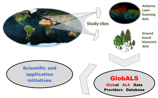
2. The GlobALS Concept

GlobALS has emerged from exchanges among a group of international researchers working at the interface of remote sensing and ecology community who exchanged ideas during conferences and project meetings and occasionally conducted joint research. Our idea was to reduce all risks associated with access to data and the cost of maintaining the network, and to create a structure that could continue to enable scientific applications without funding, hence the idea to create a database of researchers in the field of LiDAR who have data and are potentially ready to share them. We understand sharing to mean providing access to the LiDAR data itself, or allowing scripts to process inaccessible data in order to obtain specific information. Our intention was to have as few hierarchical connections as possible.
GlobALS aims to establish a database of ALS metadata and data providers, including ancillary and validation information, coupled with networking with scientific, conservation, and administrative institutions. ALS data are not directly collected from data owners/administrators, who only provide their contacts and metadata: the GlobALS network, managed by a scientific board, serves to facilitate contacts between data providers and data users. The scientific board manages data-use requests, including suggesting or reviewing specific research issues and questions; facilitates contacts and exchanges among parties; and fosters an extended participation from multiple stakeholders comprising data users and researchers. On specific research questions or conservation issues, a GlobALS target group is set up, including specific human resources for data provision, processing, analysis, and results dissemination. In this framework, data providers choose either to process their own data based on workflow instruction from the user, making available only by-products to avoid original data diffusion, or asking for support of a specific target group: different ways of collaboration (with or without direct data exchange) are proposed and agreed on. Ancillary and additional data (e.g., field validation plots, TLS, or other sources of remote sensing data) are also welcomed and supported to answer complex questions.
Multiple benefits are expected from the establishment of this GlobALS facility, the main features of which include:
  • An independent platform with international data coverage that enables cross-border research using ALS data: independent means that no international or global institution/company limits or controls the access to data, which therefore can facilitate a fully open-access initiative.
  • Opportunity to verify research hypotheses beyond local spatial domains and limited sample sets, by replicating the analysis carried out on single datasets over multiple structurally-similar sites and data over larger spatial scales.
  • Integration of multiple actors, expertise, and competencies from relevant technical and scientific fields, while additionally including the operational forestry sector in the network. This is aimed at guaranteeing the required know-how for field surveys and field data networks. This integration favors the exchange of information and knowledge, also allowing harmonization of procedures and the development of standards.
  • Sharing plans for upcoming ALS campaigns and data acquisitions, which favor synergy among teams and projects.
  • Datasets useful for evaluation of products from global satellite missions.

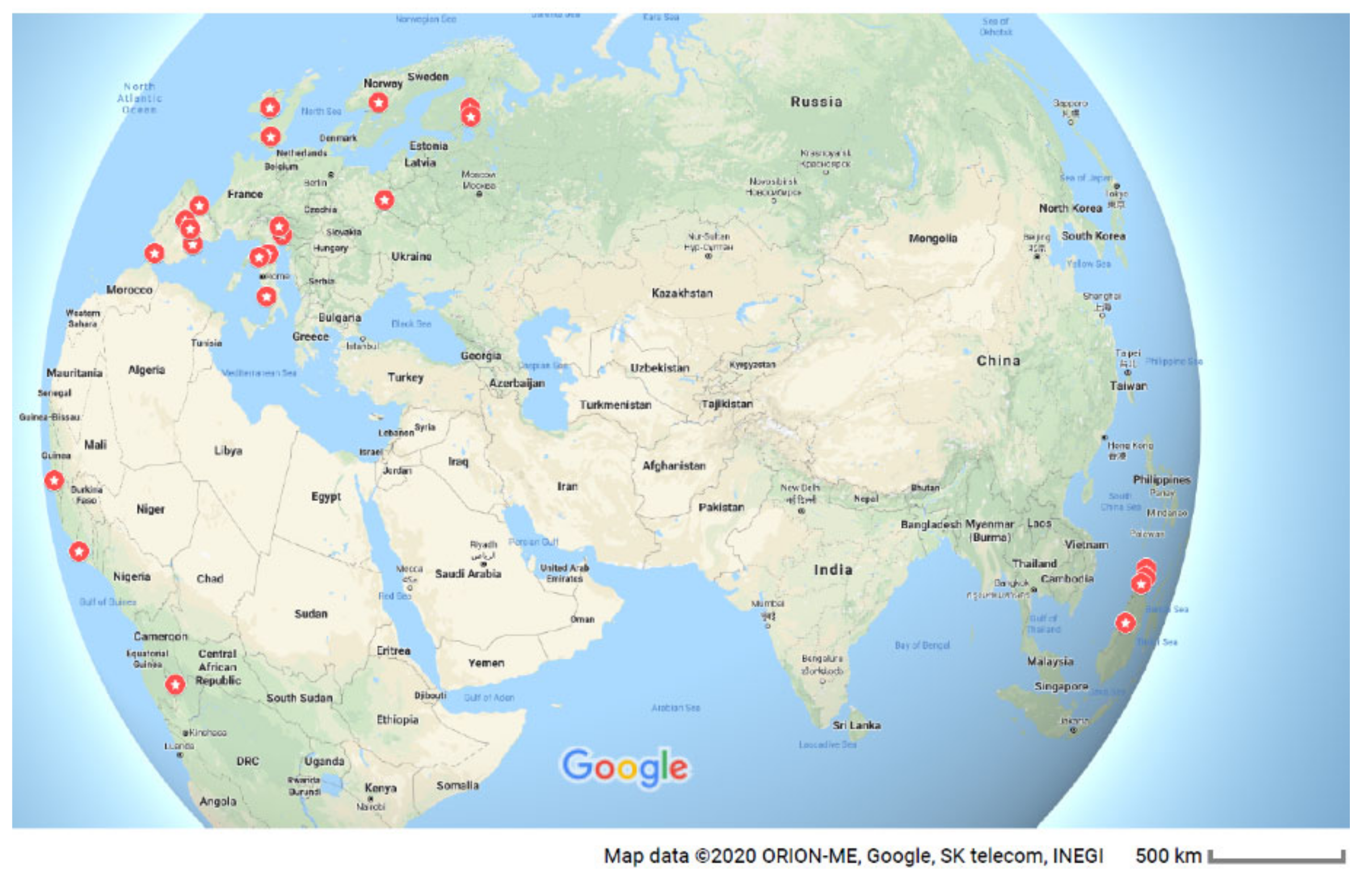
3. Implementation of GlobALS

GlobALS is being developed by a group of international researchers working at the interface between remote sensing and the ecological sciences to establish a worldwide network of ALS data willing to work together to support natural resource and biodiversity monitoring. Currently, it is an informal initiative guided by a scientific board. If the network grows, more constant and formal structures will be needed and established. Our intention is to keep the system as simple and transparent as possible. The initiative has been advertised at conferences in Italy, USA, and Poland. Subsequently, a concept note was developed and a Facebook page was created (https://www.facebook.com/GlobALSData/) to facilitate public reach-out via social media. The Facebook page seemed to be the best source to inform about this initiative to gather people ready to join it and inform about the results. Firstly, it is free; secondly, many people, especially those in the early stages of scientific development, use Facebook for promoting their scientific initiatives. Running this site does not require any additional accounts, passwords, pins, etc., which we have in excess today. From the page it is possible to access a map to visualize the currently available datasets (Figure 1) and to join the community. So far, the network’s achievements remain modest: meta-data from 27 sites have been collated, and data from these sites are now potentially available for research and monitoring purposes.
GlobALS currently covers test sites (Figure 1) in Europe (England, Finland, Ireland, Italy, Norway, Poland, and Spain), Asia (Indonesia, Malaysia), and Africa (Ghana, Sierra Leone, Republic of Congo). The GlobALS database contains the information shown in Table 1. The ALS datasets cover areas with extent from 1 to 620 km2 and have a point density ranging from 1 to 48 points per square meter. They were acquired with various instruments. The data in Ireland are from a laser scanning system placed on an unmanned aerial vehicle (UAV), with a substantially higher laser point density ranging between 250 and 300 points per square meter. The following forest types are covered by the datasets tropical wet, tropical moist, lowland tropical rain, peat swamp, Mediterranean, temporal, boreal, as well as urban forest types. The study areas worldwide are mainly covered with forest, while other land use types also occasionally occur.
In addition, in-situ data on vegetation attributes are available in most sites, which have been usually collected approximately at the same time as the ALS data. This field data represent approximately 3000 plots in total, collected over tropical, Mediterranean, and boreal forests. Traditional structural variables were collected (e.g., diameter at breast height end height), together with species composition and diversity information. Around half of the sites have additional hyperspectral and/or multispectral data, whereas Terrestrial Laser Scanner data are available in five sites.
Preliminary research goals identified by the network of researchers are, among others, to (1) estimate forest structural diversity with ALS through multiple forest conditions [23], (2) compare SAR and ALS-derived estimates in different ecosystems [32], (3) evaluate the quality of ALS data for biodiversity or ecological estimates [33], and (4) evaluate global DTMs based on ALS data [34]. Additional ideas are under evaluation, and the proposal of new research ideas is highly encouraged from the international research community.
In conclusion, this letter aims to raise awareness about GlobALS and hopefully expand the number of countries, test sites, and forest types in the meta database. Our aim is that GlobALS will help accelerate the adoption of ALS technologies, bringing together ecologists, data providers, practitioners, managers, and planners, to conceptualize international research on ALS-assisted forest inventory and analysis. The most valuable datasets are likely to be those in which LIDAR surveys are accompanied by field data acquisitions, but given the diversity of research activities using ALS datasets, we encourage all researchers with ALS datasets to spend a few moments registering their datasets, providing a starting point for the research community to develop projects together.

Author Contributions

Lead the work and invite contributors: K.S. and G.V.L. Write first draft of the manuscript: K.S. Other authors were involved in the formulation and writing of the paper. All authors have read and agreed to the published version of the manuscript.

Funding

This research was partly suported by the project LIFE + ForBioSensing PL “Comprehensive monitoring of stand dynamics in Białowieża Forest supported with remote sensing techniques” cofunded by Life Plus (contract number LIFE13 ENV/PL/000048) and Poland’s National Fund for Environmental Protection and Water Management (contract number 485/2014/WN10/OP-NM-LF/D) and partly by the project FRESh LIFE “Demonstrating Remote Sensing integration in sustainable forest management” (LIFE14/IT000414).

Acknowledgments

The authors wish to express thanks to the people who have already joined this initiative: Jose Antonio Manzanera, Erik Naesset, Cristina Pascual, Antonio García Abril, Ruben Valbuena, Petteri Packalen, Matti Maltamo, Davide Travaglini, Francesco Pirotti, Florian Siegert, Lorenzo Frizzera, Damiano Gianelle, and Debra Laefer. G.V.L. thanks the BACI project (H2020 grant agreement #640176) for providing a collaborative framework for this initiative. We thank you Marek Lisańczuk for preparing field plot graphic for Graphical Abstract.

Conflicts of Interest

The authors declare no conflict of interest.

References

  1. Sandifer, P.A.; Sutton-Grier, A.E.; Ward, B.P. Exploring connections among nature, biodiversity, ecosystem services, and human health and well-being: Opportunities to enhance health and biodiversity conservation. Ecosyst. Serv. 2015, 12, 1–15. [Google Scholar] [CrossRef] [Green Version]
  2. Cardinale, B.J.; Duffy, J.E.; Gonzalez, A.; Hooper, D.U.; Perrings, C.; Venail, P.; Narwani, A.; Mace, G.M.; Tilman, D.; Wardle, D.A.; et al. Biodiversity loss and its impact on humanity. Nature 2012, 486, 59–67. [Google Scholar] [CrossRef] [PubMed]
  3. Yoccoz, N.; Nichols, J.D.; Boulinier, T. Monitoring of biological diversity in space and time. Trends Ecol. Evol. 2001, 16, 446–453. [Google Scholar] [CrossRef]
  4. Hubau, W.; Lewis, S.L.; Phillips, O.L.; Affum-Baffoe, K.; Beeckman, H.; Cuní-Sanchez, A.; Daniels, A.K.; Ewango, C.E.N.; Fauset, S.; Mukinzi, J.M.; et al. Asynchronous carbon sink saturation in African and Amazonian tropical forests. Nature 2020, 579, 80–87. [Google Scholar] [CrossRef] [Green Version]
  5. Chave, J.; Davies, S.J.; Phillips, O.L.; Lewis, S.L.; Sist, P.; Schepashenko, D.; Armston, J.; Baker, T.R.; Coomes, D.A.; Disney, M.; et al. Ground data are essential for biomass remote sensing missions. Surv. Geophys. 2019, 40, 863–880. [Google Scholar] [CrossRef]
  6. Chirici, G.; McRoberts, R.E.; Fattorini, L.; Mura, M.; Marchetti, M. Comparing echo-based and canopy height model-based metrics for enhancing estimation of forest aboveground biomass in a model-assisted framework. Remote Sens. Environ. 2016, 174, 1–9. [Google Scholar] [CrossRef]
  7. Wu, H.; Li, Z.-L. Scale Issues in Remote Sensing: A Review on Analysis, Processing and Modeling. Sensors 2009, 9, 1768–1793. [Google Scholar] [CrossRef] [PubMed]
  8. Wedeux, B.; Dalponte, M.; Schlund, M.; Hagen, S.; Cochrane, M.; Graham, L.; Usup, A.; Thomas, A.; Coomes, D. Dynamics of a human-modified tropical peat swamp forest revealed by repeat lidar surveys. Glob. Chang. Boil. 2020. [Google Scholar] [CrossRef]
  9. Lefsky, M.A.; Cohen, W.B.; Parker, G.G.; Harding, D.J. Lidar Remote Sensing for Ecosystem Studies. BioScience 2002, 52, 19–30. [Google Scholar] [CrossRef]
  10. Hyyppä, J.; Inkinen, M. Detecting and estimating attributes for single trees using laser scanner. Photogramm. J. Finl. 1999, 16, 27–42. [Google Scholar]
  11. Næsset, E. Practical large-scale forest stand inventory using a small-footprint airborne scanning laser. Scand. J. For. Res. 2004, 19, 164–179. [Google Scholar] [CrossRef]
  12. Rodarmel, C.; Lee, M.; Gilbert, J.; Wilkinson, B.; Theiss, H.; Dolloff, J.; O’Neill, C. The Universal Lidar Error Model (Approved for Public Release: 15–144). Photogramm. Eng. Remote Sens. 2015, 81, 543–556. [Google Scholar] [CrossRef]
  13. Dong, P.; Chen, Q. LiDAR Remote Sensing and Applications; CRC Press: Boca Raton, FL, USA, 2017; p. 200. [Google Scholar]
  14. Reutebuch, E.S.; Andersen, H.-E.; McGaughey, R.J. Light Detection and Ranging (LIDAR): An emerging tool for multiple resource inventory. J. Forest. 2005, 103, 286–292. [Google Scholar]
  15. Wulder, M.A.; Bater, C.W.; Coops, N.C.; Hilker, T.; White, J.C. The role of LiDAR in sustainable forest management. For. Chron. 2008, 84, 807–826. [Google Scholar] [CrossRef] [Green Version]
  16. Müller, J.; Brandl, R. Assessing biodiversity by remote sensing in mountainous terrain: The potential of LiDAR to predict forest beetle assemblages. J. Appl. Ecol. 2009, 46, 897–905. [Google Scholar] [CrossRef]
  17. Zellweger, F.; De Frenne, P.; Lenoir, J.; Rocchini, D.; Coomes, D. Advances in microclimate ecology arising from remote sensing. Trends Ecol. Evol. 2019, 34, 327–341. [Google Scholar] [CrossRef] [Green Version]
  18. Valbuena, R.; O’Connor, B.; Zellweger, F.; Simonson, W.; Vihervaara, P.; Maltamo, M.; Silva, C.; Almeida, D.; Danks, F.; Morsdorf, F.; et al. Standardizing Ecosystem Morphological Traits from 3D Information Sources. Trends Ecol. Evol. 2020. [Google Scholar] [CrossRef]
  19. Nelson, R.; Krabill, W.; Tonelli, J. Estimating forest biomass and volume using airborne laser data. Remote Sens. Environ. 1988, 24, 247–267. [Google Scholar] [CrossRef]
  20. Zhao, K.; Popescu, S.C.; Nelson, R. Lidar remote sensing of forest biomass: A scale-invariant estimation approach using airborne lasers. Remote Sens. Environ. 2009, 113, 182–196. [Google Scholar] [CrossRef]
  21. Bouvier, M.; Durrieu, S.; Gosselin, F.; Herpigny, B. Use of airborne lidar data to improve plant species richness and diversity monitoring in lowland and mountain forests. PLoS ONE 2017, 12, e0184524. [Google Scholar] [CrossRef] [Green Version]
  22. Laurin, G.V.; Puletti, N.; Chen, Q.; Corona, P.; Papale, D.; Valentini, R. Above ground biomass and tree species richness estimation with airborne lidar in tropical Ghana forests. Int. J. Appl. Earth Obs. Geoinf. 2016, 52, 371–379. [Google Scholar] [CrossRef] [Green Version]
  23. Mura, M.; McRoberts, R.E.; Chirici, G.; Marchetti, M. Estimating and mapping forest structural diversity using airborne laser scanning data. Remote Sens. Environ. 2015, 170, 133–142. [Google Scholar] [CrossRef]
  24. Kent, R.; Lindsell, J.; Laurin, G.V.; Valentini, R.; Coomes, D. Airborne LiDAR Detects Selectively Logged Tropical Forest Even in an Advanced Stage of Recovery. Remote Sens. 2015, 7, 8348–8367. [Google Scholar] [CrossRef] [Green Version]
  25. Stereńczak, K.; Kraszewski, B.; Milecarek, M.; Piasecka, Ż. Inventory of standing dead trees in the surroundings of communication routes–The contribution of remote sensing to potential risk assessments. Forest Ecol. Manag. 2017, 402, 76–91. [Google Scholar] [CrossRef]
  26. Kaminska, A.; Lisiewicz, M.; Stereńczak, K.; Kraszewski, B.; Sadkowski, R. Species-related single dead tree detection using multi-temporal ALS data and CIR imagery. Remote Sens. Environ. 2018, 219, 31–43. [Google Scholar] [CrossRef]
  27. He, K.S.; Bradley, B.A.; Cord, A.F.; Rocchini, D.; Tuanmu, M.-N.; Schmidtlein, S.; Turner, W.; Wegmann, M.; Pettorelli, N. Will remote sensing shape the next generation of species distribution models? Remote Sens. Ecol. Conserv. 2015, 1, 4–18. [Google Scholar] [CrossRef] [Green Version]
  28. Wulder, M.A.; White, J.C.; Nelson, R.F.; Næsset, E.; Ørka, H.O.; Coops, N.C.; Hilker, T.; Bater, C.W.; Gobakken, T. Lidar sampling for large-area forest characterization: A review. Remote Sens. Environ. 2012, 121, 196–209. [Google Scholar] [CrossRef] [Green Version]
  29. Müller, J.; Vierling, K. Assessing Biodiversity by Airborne Laser Scanning. In Plant-Fire Interactions; Maltamo, M., Næsset, E., Vauhkonen, J., Eds.; Springer: Dordrecht, The Netherland, 2013; Volume 27, pp. 357–374. [Google Scholar]
  30. Wulder, M.A.; Coops, N.C.; Hudak, A.; Morsdorf, F.; Nelson, R.; Newnham, G.; Vastaranta, M. Status and prospects for LiDAR remote sensing of forested ecosystems. Can. J. Remote Sens. 2013, 39, S1–S5. [Google Scholar] [CrossRef] [Green Version]
  31. Hancock, S.; Armston, J.; Hofton, M.; Sun, X.; Tang, H.; Duncanson, L.; Kellner, J.R.; Dubayah, R. The GEDI Simulator: A Large-Footprint Waveform Lidar Simulator for Calibration and Validation of Spaceborne Missions. Earth Space Sci. 2019, 6, 294–310. [Google Scholar] [CrossRef]
  32. Laurin, G.V.; Pirotti, F.; Callegari, M.; Chen, Q.; Cuozzo, G.; Lingua, E.; Notarnicola, C.; Papale, D. Potential of ALOS2 and NDVI to estimate forest above-ground biomass, and comparison with lidar-derived estimates. Remote Sens. 2016, 9, 18. [Google Scholar] [CrossRef] [Green Version]
  33. Laurin, G.V.; Ding, J.; Disney, M.; Bartholomeus, H.; Herold, M.; Papale, D.; Valentini, R. Tree height in tropical forest as measured by different ground, proximal, and remote sensing instruments, and impacts on above ground biomass estimates. Int. J. Appl. Earth Obs. Geoinf. 2019, 82, 101899. [Google Scholar] [CrossRef]
  34. Hawker, L.; Neal, J.; Bates, P. Accuracy assessment of the TanDEM-X 90 Digital Elevation Model for selected floodplain sites. Remote Sens. Environ. 2019, 232, 111319. [Google Scholar] [CrossRef]
Figure 1. Distribution of the 27 datasets available in the GlobALS network (red pins).
Remotesensing 12 01877 g001
Table 1. Groups of metadata collected in the GlobALS database.
General InformationResponsible person/s
E-mail address to contact person
Geographic region/location
Area centroid latitude (°)
Area centroid longitude (°)
Dominant land cover type in % (i.e., forest (80%), water (20%))
Forest type
ALS data informationLidar collection year/mouth
Lidar data density [LE pts/m2]
km2 of lidar coverage
Lidar type and model (# returns, discrete/waveform)
Field data informationField data collection year
Number of field plots
Size of field plots
Other possible data availableALS-based continuous AGB map available? (YES/NO)
Best AGB allometric equation per species (YES/NO)
Biomass Expansion Factor (BEF) per species (YES/NO)
Best Wood Density (WD) per species (YES/NO)
Biomass Conversion and Expansion Factors (BCEF) per species (YES/NO)
TLS data available? (YES/NO)
Hyperspectral data available? (YES/NO)
Multispectral data available? (YES/NO)
Other available data

