
Volcanic Plume CO2 Flux Measurements at Mount Etna by Mobile Differential Absorption Lidar


 , ,
, ,
Abstract
:1. Introduction
2. Materials and Methods
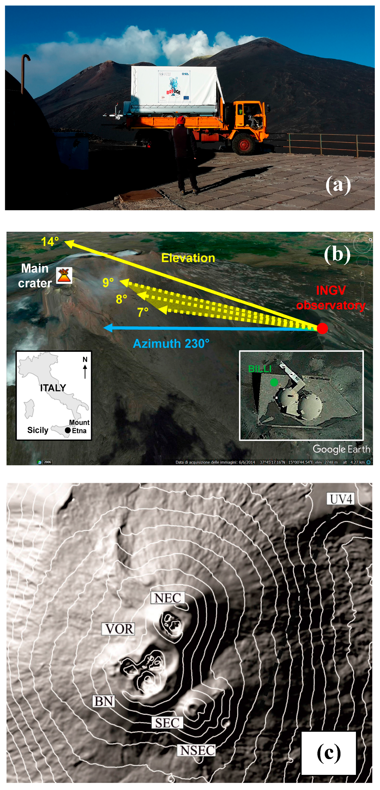
2.1. Field Set-Up on Mt. Etna
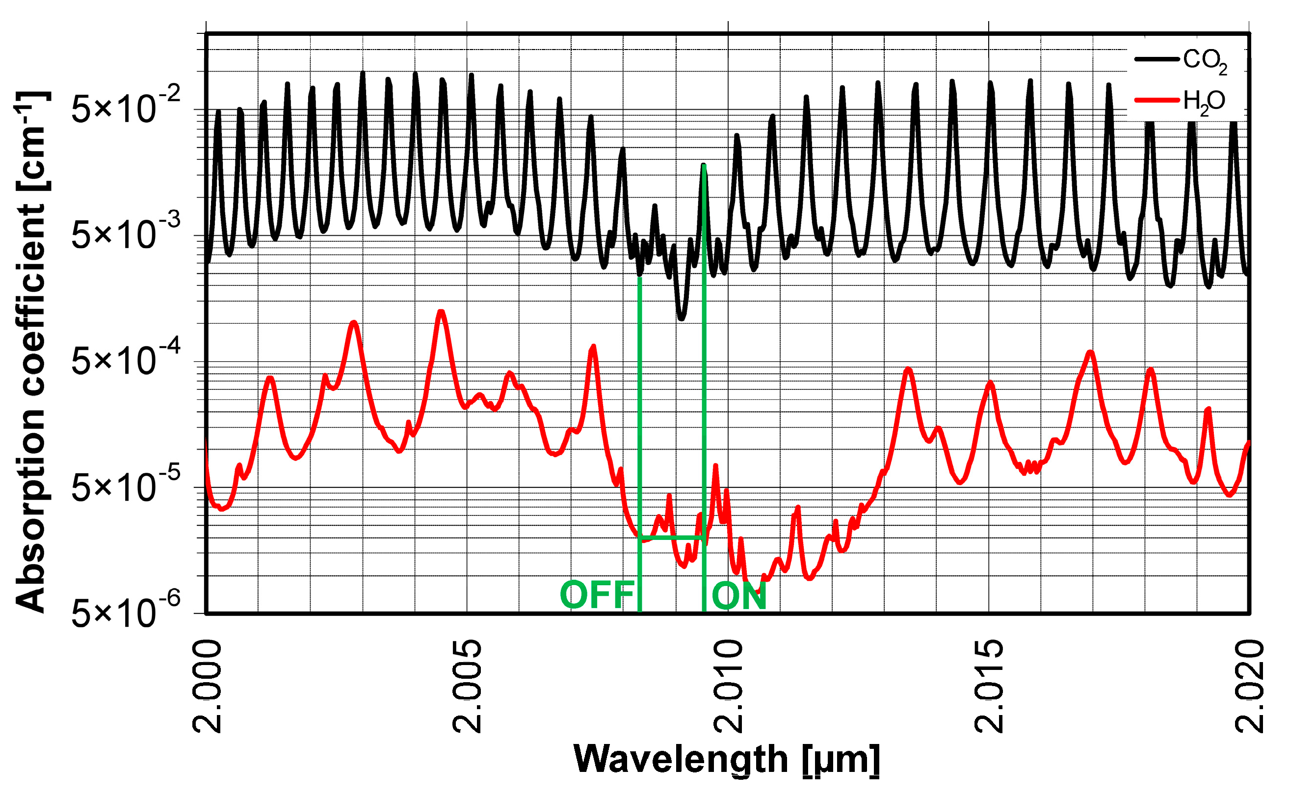
2.2. DIAL
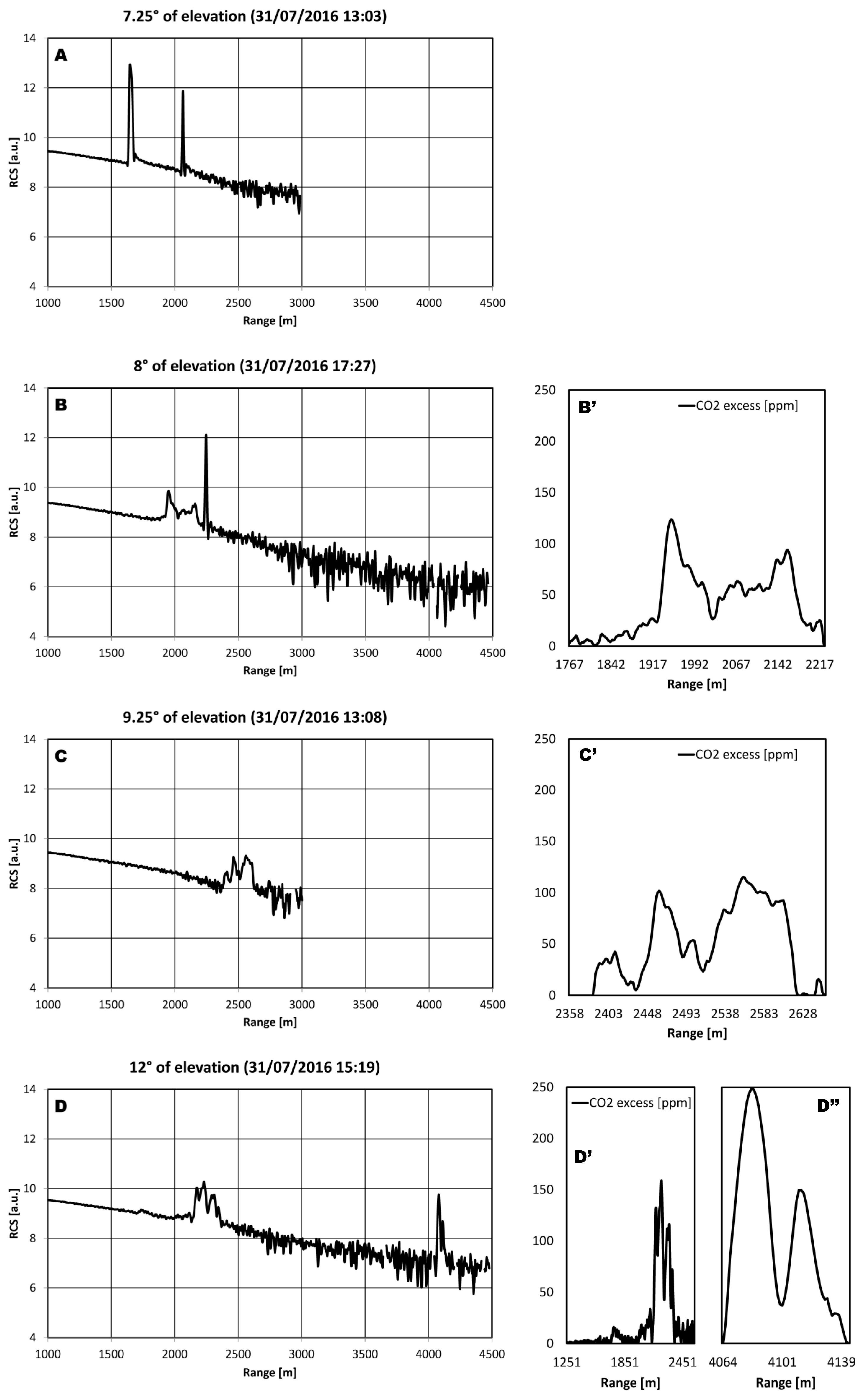
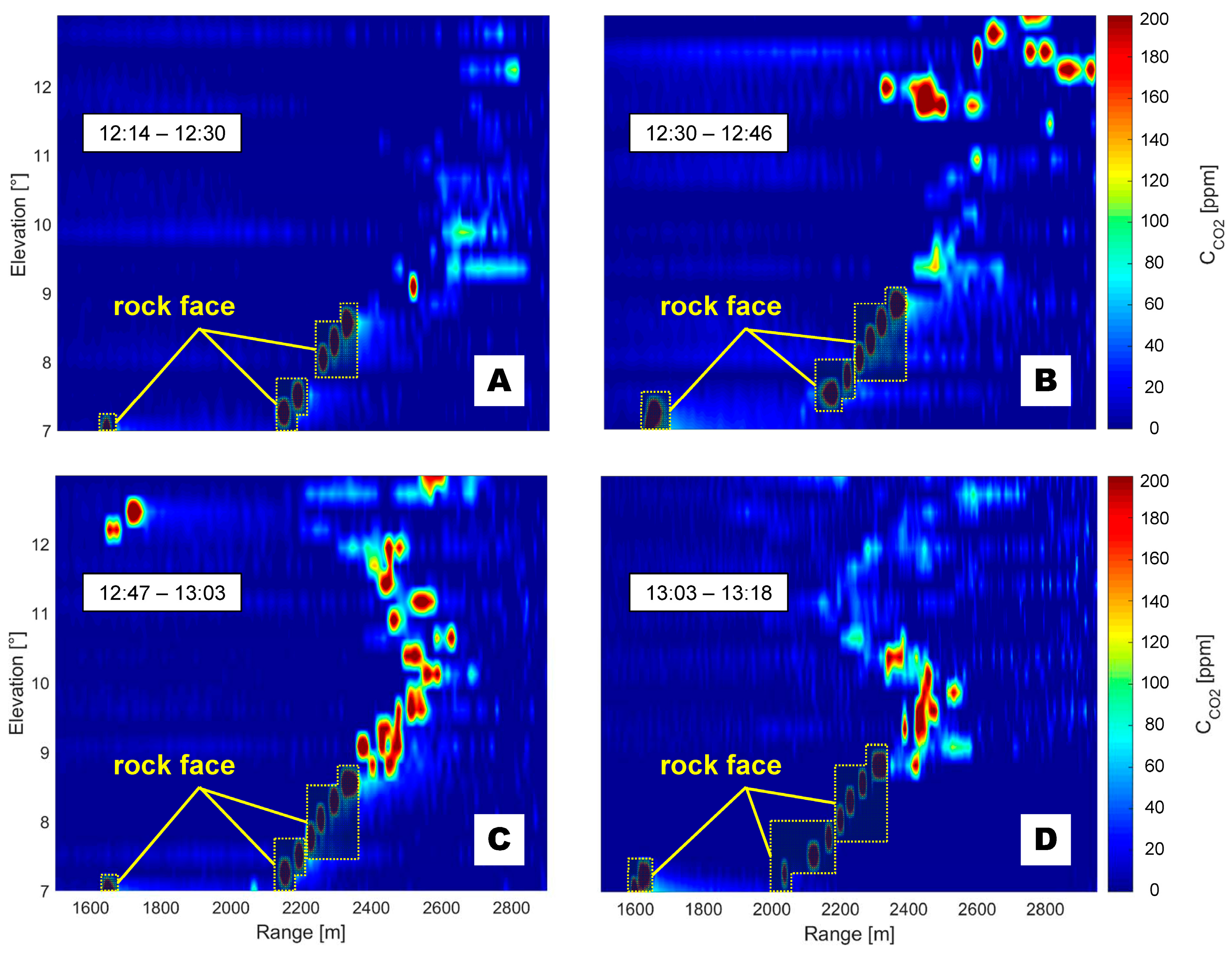
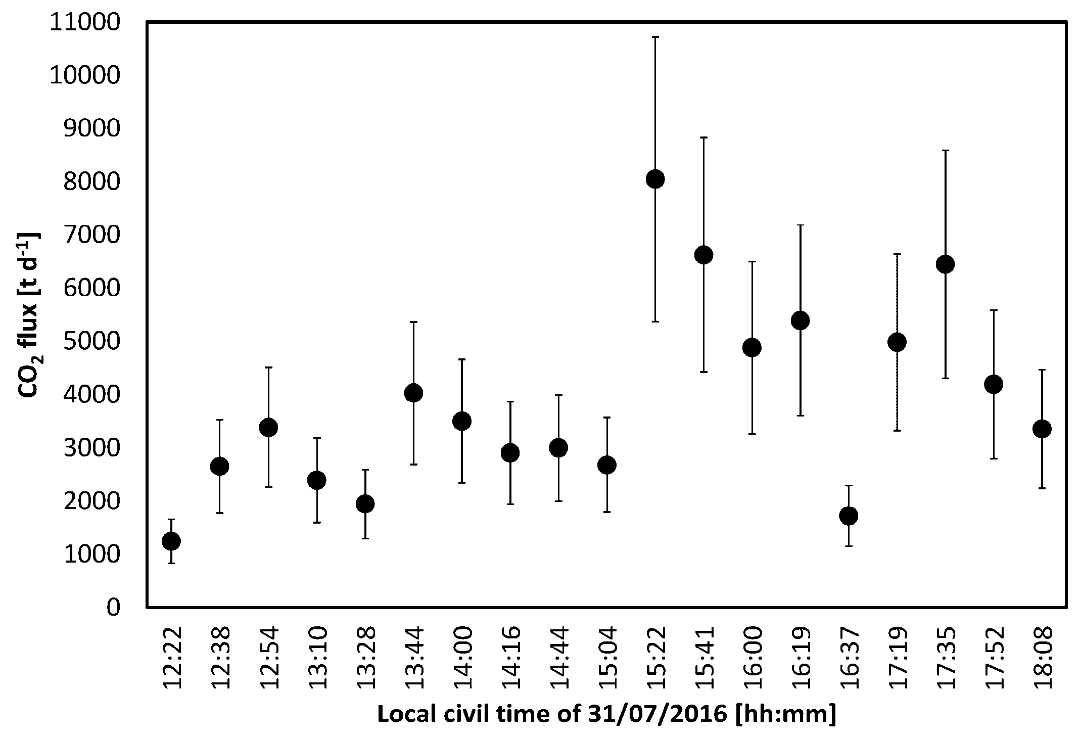
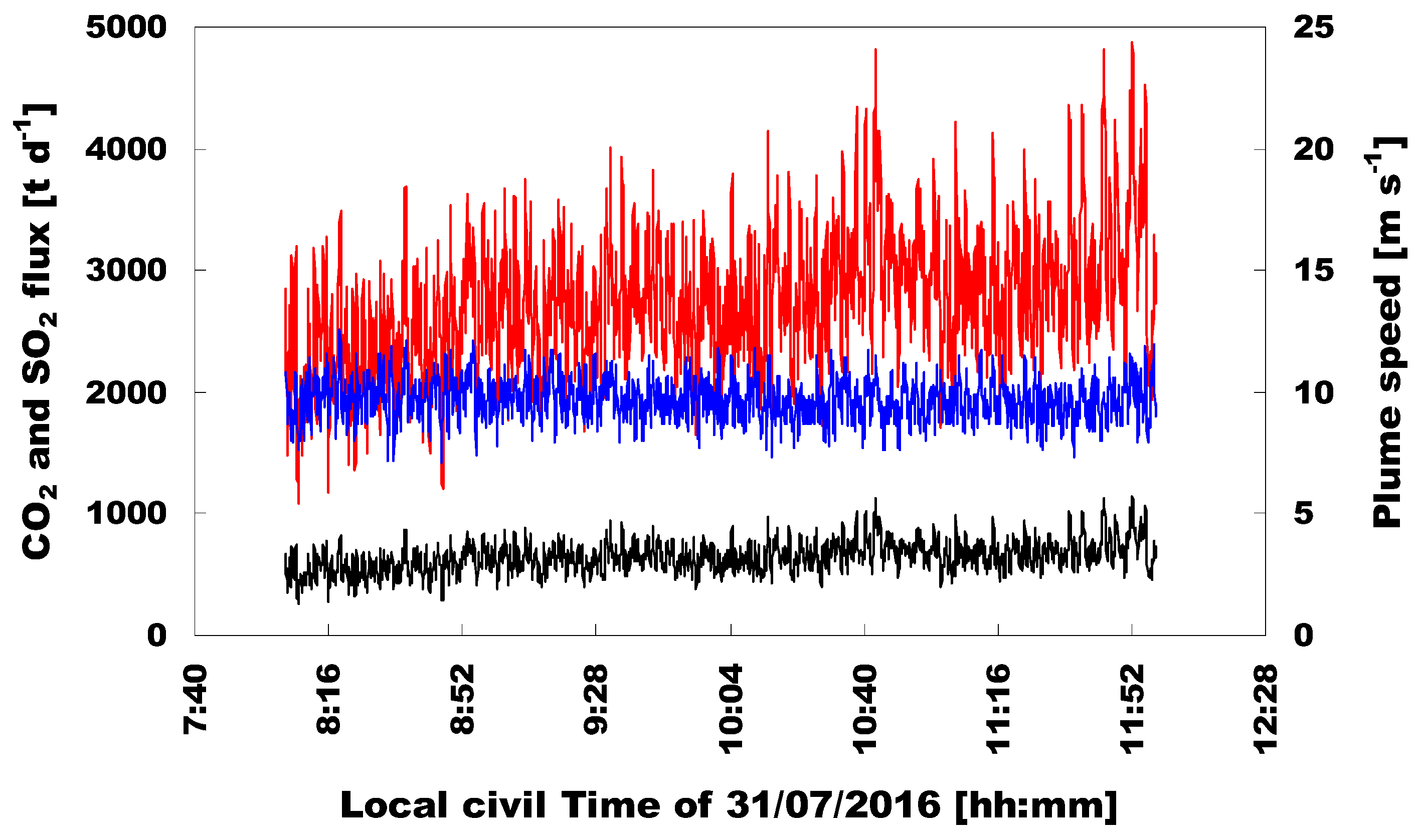
3. Results
- exponentially, due to atmospheric extinction, according to the Lambert-Beer law, and;
- as 1/R2, because the solid angle subtended by the receiver is A/R2, where A is the telescope effective area.
4. Discussion
5. Conclusions
Acknowledgments
Author Contributions
Conflicts of Interest
References
- Oppenheimer, C.; Fischer, T.P.; Scaillet, B. Volcanic Degassing: Process and Impact. In Treatise on Geochemistry, The Crust, 2nd ed.; Holland, H.D., Turekian, K.K., Eds.; Elsevier: Amsterdam, The Netherlands, 2014; Volume 4, pp. 111–179. [Google Scholar]
- Carn, S.A.; Clarisse, L.; Prata, A.J. Multi-decadal satellite measurements of global volcanic degassing. J. Volcanol. Geothermal Res. 2016, 311, 99–134. [Google Scholar] [CrossRef]
- Aiuppa, A. Volcanic gas monitoring. In Volcanism and Global Environmental Change; Schmidt, A., Fristad, K.E., Elkins-Tanton, L.T., Eds.; Cambridge University Press: Cambridge, UK, 2015; pp. 81–96. [Google Scholar]
- Edmonds, M. New geochemical insights into volcanic degassing. Philos. Trans. R. Soc. A Math. Phys. Eng. Sci. 2008, 366, 4559–4579. [Google Scholar] [CrossRef] [PubMed] [Green Version]
- Allard, P.; Carbonnelle, J.; Métrich, N.; Loyer, H.; Zettwoog, P. Sulphur output and magma degassing budget of Stromboli volcano. Nature 1994, 368, 326–330. [Google Scholar] [CrossRef]
- Saccorotti, G.; Iguchi, M.; Aiuppa, A. In situ Volcano Monitoring: Present and Future. In Volcanic Hazards, Risks and Disasters; Elsevier: Amsterdam, The Netherlands, 2014; pp. 169–202. [Google Scholar]
- Aiuppa, A.; Burton, M.; Caltabiano, T.; Giudice, G.; Guerrieri, S.; Liuzzo, M.; Murè, F.; Salerno, G. Unusually large magmatic CO2 gas emissions prior to a basaltic paroxysm. Geophys. Res. Lett. 2010, 37, L17303. [Google Scholar] [CrossRef]
- Burton, M.R.; Sawyer, G.M.; Granieri, D. Deep carbon emissions from volcanoes. Rev. Mineral. Geochem. 2013, 75, 323–354. [Google Scholar] [CrossRef]
- Aiuppa, A.; Fiorani, L.; Santoro, S.; Parracino, S.; Nuvoli, M.; Chiodini, G.; Minopoli, C.; Tamburello, G. New ground-based lidar enables volcanic CO2 flux measurements. Sci. Rep. 2015, 5, 13614. [Google Scholar] [CrossRef] [PubMed] [Green Version]
- Queißer, M.; Granieri, D.; Burton, M. A new frontier in CO2 flux measurements using a highly portable DIAL laser system. Sci. Rep. 2016, 6, 33834. [Google Scholar]
- Allard, P.; Carbonnelle, J.; Dajlevic, D.; le Bronec, J.; Morel, P.; Robe, M.C.; Maurenas, J.M.; Faivre-Pierret, R.; Martin, D.; Sabroux, J.C.; et al. Eruptive and diffuse emissions of CO2 from Mount Etna. Nature 1991, 351, 387–391. [Google Scholar] [CrossRef]
- Aiuppa, A.; Federico, C.; Giudice, G.; Gurrieri, S.; Liuzzo, M.; Shinohara, H.; Favara, R.; Valenza, M. Rates of carbon dioxide plume degassing from Mount Etna volcano. J. Geophys. Res. 2006, 111, B09207. [Google Scholar] [CrossRef]
- Aiuppa, A.; Giudice, G.; Gurrieri, S.; Liuzzo, M.; Burton, M.; Caltabiano, T.; McGonigle, A.J.S.; Salerno, G.; Shinohara, H.; Valenza, M. Total volatile flux from Mount Etna. Geophys. Res. Lett. 2008, 35, L24302. [Google Scholar] [CrossRef]
- Patanè, D.; Aiuppa, A.; Aloisi, M.; Behncke, B.; Cannata, A.; Coltelli, M.; di Grazia, G.; Gambino, S.; Gurrieri, S.; Mattia, M.; et al. Insights into magma and fluid transfer at Mount Etna by a multiparametric approach: A model of the events leading to the 2011 eruptive cycle. J. Geophys. Res. Solid Earth 2013, 118, 3519–3539. [Google Scholar] [CrossRef]
- Pering, T.D.; Tamburello, G.; McGonigle, A.J.S.; Aiuppa, A.; Cannata, A.; Giudice, G.; Patanè, D. High time resolution fluctuations in volcanic carbon dioxide degassing from Mount Etna. J. Volcanol. Geotherm. Res. 2014, 270, 115–121. [Google Scholar] [CrossRef]
- La Spina, A.; Burton, M.; Salerno, G.G. Unravelling the processes controlling gas emissions from the central and northeast craters of Mt. Etna. J. Volcanol. Geotherm. Res. 2010, 198, 368–376. [Google Scholar] [CrossRef]
- Caltabiano, T.; Burton, M.; Giammanco, S.; Allard, P.; Bruno, N.; Murè, F.; Romano, R. Volcanic Gas Emissions from the Summit Craters and Flanks of Mt. Etna, 1987–2000. In Mt. Etna: Volcano Laboratory; Bonaccorso, A., Calvari, S., Coltelli, M., del Negro, C., Falsaperla, S., Eds.; Geophysical Monograph Series; American Geophysical Union: Washington, DC, USA, 2004; Volume 143, pp. 111–128. [Google Scholar]
- Allard, P.; Behncke, B.; D’Amico, S.; Neri, M.; Gambino, S. Mount Etna 1993–2005: Anatomy of an evolving eruptive cycle. Earth-Sci. Rev. 2006, 78, 85–114. [Google Scholar] [CrossRef]
- Fiorani, L. Lidar application to litosphere, hydrosphere and atmosphere. In Progress in Laser and Electro-Optics Research; Koslovskiy, V.V., Ed.; Nova: New York, NY, USA, 2010; pp. 21–75. [Google Scholar]
- Fiorani, L.; Colao, F.; Palucci, A. Measurement of Mount Etna plume by CO2-laser-based lidar. Opt. Lett. 2009, 34, 800–802. [Google Scholar] [CrossRef] [PubMed]
- Fiorani, L.; Colao, F.; Palucci, A.; Poreh, D.; Aiuppa, A.; Giudice, G. First-time lidar measurement of water vapor flux in a volcanic plume. Opt. Commun. 2011, 284, 1295–1298. [Google Scholar] [CrossRef]
- Fiorani, L.; Santoro, S.; Parracino, S.; Nuvoli, M.; Minopoli, C.; Aiuppa, A. Volcanic CO2 detection with a DFM/OPA-based lidar. Opt. Lett. 2015, 40, 1034–1036. [Google Scholar] [CrossRef] [PubMed]
- Fiorani, L.; Santoro, S.; Parracino, S.; Maio, G.; Nuvoli, M.; Aiuppa, A. Early detection of volcanic hazard by lidar measurement of carbon dioxide. Nat. Hazards 2016, 83, S21–S29. [Google Scholar] [CrossRef]
- Aiuppa, A.; Fiorani, L.; Santoro, S.; Parracino, S.; D’Aleo, R.; Liuzzo, M.; Maio, G.; Nuvoli, M. Advances in Dial-Lidar-based remote sensing of the volcanic CO2 flux. Front. Earth Sci. 2017, 5, 15. [Google Scholar] [CrossRef]
- Scollo, S.; Boselli, A.; Coltelli, M.; Leto, G.; Pisani, G.; Spinelli, N.; Wang, X. Monitoring Etna volcanic plumes using a scanning LiDAR. Bull. Volcanol. 2012, 74, 2383–2395. [Google Scholar] [CrossRef]
- Wanga, X.; Boselli, A.; D’Avino, L.; Pisani, G.; Spinelli, N.; Amodeo, A.; Chaikovsky, A.; Wiegner, M.; Nickovic, S.; Papayannis, A.; et al. Volcanic dust characterization by EARLINET during Etna’s eruptions in 2001–2002. Atmos. Environ. 2008, 42, 893–905. [Google Scholar] [CrossRef]
- Rothman, L.S.; Gordon, I.E.; Babikov, Y.; Barbe, A.; Benner, D.C.; Bernath, P.F.; Birk, M.; Bizzocchi, L.; Boudon, V.; Brown, L.R.; et al. The HITRAN2012 molecular spectroscopic database. J. Quant. Spectrosc. Radiat. Transf. 2013, 130, 4–50. [Google Scholar] [CrossRef]
- Schafer, R.W. What is a Savitzky-Golay Filter? IEEE Signal Process Mag. 2011, 28, 111–117. [Google Scholar] [CrossRef]
- D’Aleo, R.; Bitetto, M.; Delle Donne, D.; Tamburello, G.; Battaglia, A.; Coltelli, M.; Patanè, D.; Prestifilippo, M.; Sciotto, M.; Aiuppa, A. Spatially resolved SO2 flux emissions from Mt Etna. Geophys. Res. Lett. 2016, 43. [Google Scholar] [CrossRef] [PubMed]
- Bruhn, A.; Weickert, J.; Schnörr, C. Lucas/Kanade Meets Horn/Schunck: Combining Local and Global Optic Flow Methods. Int. J. Comput. Vis. 2005, 61, 211–231. [Google Scholar] [CrossRef]
- Peters, N.; Hoffmann, A.; Barnie, T.; Herzog, M.; Oppenheimer, C. Use of motion estimation algorithms for improved flux measurements using SO2 cameras. J. Volcanol. Geotherm. Res. 2015, 300, 58–69. [Google Scholar] [CrossRef]
- Tamburello, G.; Kantzas, E.P.; McGonigle, A.J.S.; Aiuppa, A. Vulcamera: A program for measuring volcanic SO2 using UV cameras. Ann. Geophys. 2011, 54, 2. [Google Scholar] [CrossRef]
- Fischer, T.P.; Chiodini, G. Volcanic, Magmatic and Hydrothermal Gas Discharges. In Encyclopaedia of Volcanoes, 2nd ed.; Elsevier: Amsterdam, The Netherlands, 2015; pp. 779–797. [Google Scholar]


| Campaign | Pozzuoli Solfatara | Stromboli Volcano | Mt. Etna |
|---|---|---|---|
| Latitude | 40°49′46.28″N | 38°48′06.69″N | 37°45′57.28″N |
| Longitude | 14°08′50.51″E | 15°14′25.69″E | 15°00′59.65″E |
| Period | 13–17 October 2014 | 24–29 June 2015 | 28 July–1 August 2016 |
| Azimuth scan | 196°–234° | 235.3°–253.6° | 230° |
| Elevation scan | 0°–18° | 15.2°–27.4° | 7°–14° |
© 2017 by the authors. Licensee MDPI, Basel, Switzerland. This article is an open access article distributed under the terms and conditions of the Creative Commons Attribution (CC BY) license ( http://creativecommons.org/licenses/by/4.0/).
Share and Cite
Santoro, S.; Parracino, S.; Fiorani, L.; D’Aleo, R.; Di Ferdinando, E.; Giudice, G.; Maio, G.; Nuvoli, M.; Aiuppa, A. Volcanic Plume CO2 Flux Measurements at Mount Etna by Mobile Differential Absorption Lidar. Geosciences 2017, 7, 9. https://doi.org/10.3390/geosciences7010009
Santoro S, Parracino S, Fiorani L, D’Aleo R, Di Ferdinando E, Giudice G, Maio G, Nuvoli M, Aiuppa A. Volcanic Plume CO2 Flux Measurements at Mount Etna by Mobile Differential Absorption Lidar. Geosciences. 2017; 7(1):9. https://doi.org/10.3390/geosciences7010009
Chicago/Turabian StyleSantoro, Simone, Stefano Parracino, Luca Fiorani, Roberto D’Aleo, Enzo Di Ferdinando, Gaetano Giudice, Giovanni Maio, Marcello Nuvoli, and Alessandro Aiuppa. 2017. "Volcanic Plume CO2 Flux Measurements at Mount Etna by Mobile Differential Absorption Lidar" Geosciences 7, no. 1: 9. https://doi.org/10.3390/geosciences7010009