 Anitra Pawley
 David Moldoff
 Josh Brown1
- 1Division of Multi-Benefit Initiatives, California Department of Water Resources, Sacramento, CA, United States
- 2Division of Flood Management, California Department of Water Resources, Sacramento, CA, United States
- 3Ecosystem Investment Partners, Sausalito, CA, United States
Sacramento, the capital of California, has a population of over 2 million and is one of the most flood prone regions in the nation. Its problems exemplify those of many urban communities built near riverine and deltaic systems, that are subject to climate change. The city and its surrounding communities are protected by an elaborate system of levees and flood bypasses; but aging infrastructure, expected increases in extreme wet weather, and projected sea level rise are increasing the risk of levee failures. We explore how flood management approaches including social/institutional (non-structural), traditional structural, and ecological based approaches are being implemented in the Lower Sacramento/North Delta Region amid significant obstacles, to build resilient flood management systems. We review four case studies, one structural levee project and three multi-benefit projects that are only recently being implemented. We also examine the barriers, constraints, and challenges for implementing flood protection projects, and how project proponents are collectively working through these obstacles. We conclude that significant progress has been made in building flood resiliency since the 2008 Central Valley Flood Protection Act and the release of the 2012 Central Valley Flood Protection Plan. Informational tools and policies are being developed to educate the public and prepare for floods. Structural levee investments are substantial and are being implemented through partnerships. Statewide policies and investments are increasingly supporting multi-benefit projects that incorporate ecological restoration/enhancement while expanding flood volume capacity. Progress on implementing multi-benefit projects has been slow, due to land acquisition, easements, funding, regulatory and construction challenges; however, solutions to these impediments are emerging to facilitate more rapid progress. It is essential to continue and intensify the progress made in the last two decades, by learning from past projects, and improving on existing pathways to implement sustainable projects at a faster rate.
1. Introduction
The City of Sacramento, at the base of the Sacramento watershed (Figure 1), is the capital of California, with a population of over 2 million and is in one of the most flood prone regions in the nation (DWR, 2022d). Built on a large alluvial floodplain, it epitomizes the historical trend for cities to become established along rivers, in areas that are highly susceptible to flooding. Sacramento and the surrounding region are protected by an elaborate system of levees and flood bypasses; allowing Sacramento and adjacent communities to become more populated over time. Although this flood management system has been effective, aging infrastructure and land subsidence, along with the predicted increases in the variability of extreme precipitation events and projected sea level rise due to climate change, are increasing the risk of levee failure over time (Brooks et al., 2018; DWR, 2022d). The recent 2023 January floods, affecting much of California and in particular local areas just south of Sacramento, provided a strong reminder of the force that floods can bring and the value of maintaining existing structures, increasing capacity, and improving community understanding of flood risk (Clift, 2023).
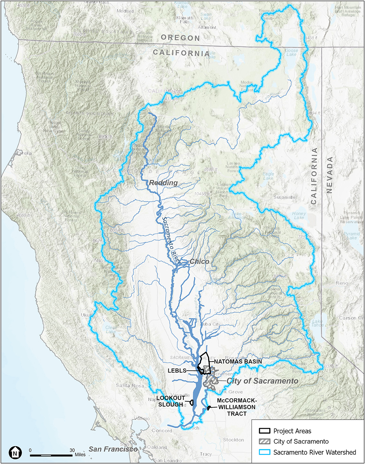
Figure 1. Sacramento River watershed showing the location of the City of Sacramento and the geographic area, the “Lower Sacramento River/Delta North Region”. The location of the structural and multi-benefit projects included in this review are indicated in the figure. ESA with Esri and DWR input.
The key to preparing for flood resilience is to stabilize and improve upon those elements of the existing flood management system that are effective, while identifying additional methods to increase flood capacity and implementing innovative solutions to the problems that have impeded progress to date. The 2008 Central Valley Flood Protection Act required the State to prepare the Central Valley Flood Protection Plan (CVFPP), a plan to reduce flood risk in California and to update the plan every 5 years. Substantial progress has been made in reducing flood risk in the Sacramento Region since the Act became law and the first release of the CVFPP in 2012. We confine this review to the predominantly urban core and surrounding communities of the Sacramento Region similar to CVFPP's Lower Sacramento River/North Delta region (Figure 2) and explore how flood management approaches are being implemented by a range of entities and programs amid significant obstacles, to build resilient, functioning flood management systems (see Table 1 for acronyms). This is important as levee slope instability occurrences were found to be mostly in this region (DWR, 2022b). We also examine the barriers, constraints, and challenges for establishing improved flood risk management practices and projects, and how project proponents are collectively working through these obstacles.

Figure 2. The Sacramento River Flood Control Project showing the system of levees and flood bypasses that protect the City of Sacramento and surrounding communities. The location of the structural and multi-benefit projects included in this review are indicated in the figure. ESA with Esri and DWR input.

Table 1. Acronyms and definitions.
The term resilience was first introduced in the field of ecology by Holling (1973) and relates to a system's ability to resume functionality in the wake of a perturbation (McClymont et al., 2020). It is now used widely throughout climate change literature, as the public is increasingly faced with the realization that systems must adapt and recover from climate change rather than resist change (Zevenbergen et al., 2020). For “flood system resilience”, the flood management system must continue to function and recover quickly after damaging floods. Increased flood system resiliency can be achieved by increasing the robustness of flood management improvements—implementing adaptation measures that reduce the time and cost of flood recovery; improving emergency preparedness and response; and improving system redundancy, particularly in high-risk areas (DWR, 2017, 2022a). Developing resilience requires that a region employ a full range of actions from educational and planning methods to structural solutions. By evaluating the flood management system, plans, and some of the projects implemented to prepare for floods and improve flood management in the Sacramento Region, we will assess the progress being made on developing flood resilience.
There are multiple approaches for improving an urban area's flood resilience and ways to categorize these methods. For the sake of discussion, we divided these methods into social/institutional (non-structural), traditional structural engineering, and ecological based approaches employing nature-based solutions (NbS) (Table 2). Despite this categorization, these methods do not fit neatly into discrete categories. In combination, these methods can create an overall flood risk management strategy that facilitates resilience to floods; however, despite ongoing investment, a flood management system, particularly one built in an urban environment, requires constant maintenance and input of resources. Sustainability and increased resilience require that we advance new methods that lower maintenance costs. By allowing rivers more “room to roam” and restoring floodplains, we can implement ecological strategies or NbS–sustainable planning, design, environmental and engineering practices that weave natural features or processes into the built environment to promote adaptation and resilience (FEMA, 2021; IUCN, 2021). This concept is not new (Sparks et al., 1998); however, the focus on establishing projects that work with nature is an increasingly urgent one as climate change increases the threat and severity of flooding. Habitat restoration actions can be included in flood infrastructure improvement projects to provide ecological benefits and are also termed “multi-benefit projects”. California legislators and managers, like their international counterparts (European Commission, 2007; Golfieri et al., 2017; Martin et al., 2021; Serra-Llobet et al., 2022b; Thaler et al., 2023), are increasing their support for these concepts, but project implementation is frequently slow paced and difficult. We present case studies from the lower Sacramento Region (Figures 1, 2) to provide an overview of the many challenges for completing these projects and ideas for overcoming obstacles. These projects have gained insights from earlier examples and their scope and unique location, present opportunities to provide lessons that can be applied to flood risk reduction projects in other lowland urban settings.
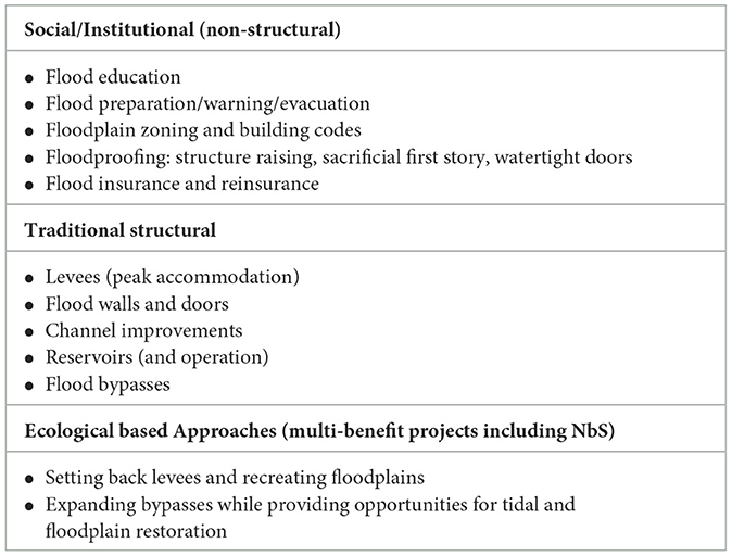
Table 2. Flood management strategies.
2. Sacramento's location and flood history
The Sacramento River Watershed encompasses some 27,000 square miles and drains most of Northern California through the Central Valley, eventually flowing to the San Francisco Bay and Pacific Ocean. The City of Sacramento, at the base of this vast watershed, has experienced flooding from its early settlement period. Located at the confluence of the Sacramento and American Rivers, Sacramento was settled in the 1840s due to its proximity to the rivers and rich fertile ground. Sacramento's population and spatial extent further increased with the discovery of gold in 1849 at Sutter's Mill, just east of the settlement in the Sierra foothills. The California goldrush further exacerbated natural flooding problems as mining debris from the hydraulic mines in the Sierra along the American River led to increases in the debris which clogged river channels. Area farmers built a piecemeal flood control system of levees, embankments, and channels to protect themselves from the frequent river inundations; however, this early patchwork of levees provided little protection from the large flood events of the late 1800s (City of Sacramento, 2017). As Sacramento became California's capital in 1862, the newly elected Governor, Leland Stanford, had to travel to his inauguration in a rowboat (Kelley and Kennedy, 1998). This “mega flood” as it is now called, was followed by more levee improvements in what is now downtown Sacramento, and the raising of streets by as much as 14 feet.
Sacramento is also located on the northwest side of the Sacramento San Joaquin Delta, a large inland sea -extending throughout the Central Valley. The tide extends nearly 70 miles inland from the Pacific Ocean; creating freshwater tidal areas at its most inland reaches. This area once held an immense expanse of tidal wetlands that swelled when the rivers overtopped their banks each year. As Sacramento grew, natural floodplains and tidal wetlands that acted as flood basins, were reclaimed and Sacramento's resilience to flooding diminished. Between the 1800s and the early 2000s, tidal wetlands in the Delta shrank by approximately 98 percent (Whipple et al., 2012). The Delta now contains approximately 1,100 miles of levees, that protect reclaimed agricultural islands with Reclamation Districts responsible for managing and maintaining the levees. Over time, this has become an increasingly difficult task due to subsidence and increasing weather extremes due to climate change.
Though in the early days of Sacramento's development and land reclamation, there was little overall coordination of flood management, the floods in the latter part of the century lead to more wide-ranging plans. State Engineer William Hammond Hall developed an integrated, comprehensive flood control plan for the Sacramento Valley, which lead to state and federal government coordination (Kelley and Kennedy, 1998). The US Congress authorized the Sacramento River Flood Control Project (SRFCP) in 1917, which constructed levees along the Sacramento and American River channels, paralleled by large, leveed overflow channels, connected to the rivers through a series of weirs and bypasses (Figure 2). In the lower Sacramento River, surrounding the City of Sacramento, two wide sections of the floodplain were set aside as managed floodplain and bounded by levees to safely convey flows in excess of river channel capacity to the Delta. These areas, known as flood bypasses, include the Sutter bypass to the north and the Yolo bypass to the south (Kelley, 1998). The construction of the SRFCP continued for decades and in 1944, the project was regarded as being about 90-percent complete. The Central Valley Project complemented the SRFCP, by establishing dams and reservoirs in the Sierra foothills to further enhance the flood control system. By 1950, the flood management system surrounding Sacramento included the Sacramento bypass and weir, Fremont weir, Yolo bypass and Folsom dam on the American River.
From the 1950s on, Sacramento continued to grow in all directions to include the North Sacramento/Natomas area to the north, and the South Sacramento to Elk Grove areas to the south. Sacramento expanded on the east side of the river, while communities such as Woodland, West Sacramento and Davis continued to grow on the west side. Today, Sacramento is the economic hub of a six-county metropolitan area (El Dorado, Placer, Sacramento, Sutter, Yolo, and Yuba counties) and the largest city in the Central Valley. Covering an area of approximately 99 square miles, Sacramento is the seventh most populous city in California with a population of 2,155,000 (MacroTrends, 2023) and has one of the highest population growth rates in California.
Sacramento's spatial patterns of expansion, and its location on the confluence of the Sacramento and the American Rivers, means that existing levees leave little room for rivers to spread out during floods, creating significant pressure on the surrounding levees. For example, this vulnerability was exposed in 1986 when the flood storage capacity of Folsom Dam was exceeded, and resulting releases of floodwater caused several levees to nearly collapse under the strain (OPC, 2022). The levees in the Natomas area along the Sacramento River that had been built from alluvial sediment, were rather sandy, and when the water was up against them for a long time, water began to seep through the levees. In present day Sacramento, the Sacramento River's main channel carries a capacity of approximately 107,000 cubic feet per second (cfs) north of the American River, while the American River can carry approximately 115,000 cfs. However, due to the constriction on the river placed by the surrounding levees, when these two rivers merge, only 110,000 cfs can emerge from the greater Sacramento area down the main channel to San Francisco Bay (Kilpatrick, 2021). Water backs up along the Sacramento River near the confluence, overtops the Sacramento and Yolo weirs and enter the flood basins on the west side of the Sacramento River. These flood bypasses provide water volume capacity, reducing the constricted flow, thereby reducing the pressure on levees that can result in levee failures.
Through the years, Sacramento has continued to experience record flood events (Figure 3A), that test its ability to manage the large volumes of water that put pressure on the existing infrastructure and threaten its increasing population (National Research Council, 1999; Hanak and Lund, 2012). With the advent of Hurricane Katrina in 2005, Sacramento's flood risk began to be compared to that of New Orleans and Californians policy makers began to clamor for additional levee improvements. The public's steadily increasing awareness of climate change has heightened this sense of urgency. The predicted effects of climate change, reductions in snowpack and shifts from snowfall to rainfall are expected to increase flood peak flows and flood volumes (Hanak and Lund, 2012). In the Sacramento area, earthquakes, though infrequent, are also a constant threat to levees and have the potential to impact the existing levees and flood basins that provide protection (Mount and Twiss, 2005; DWR, 2009). Despite the area's intricate flood management system, many of the levees are aging and require maintenance to ensure SRFCP's continued protection of Sacramento and its surrounding communities. Without sustained maintenance and improvement of these levee systems and flood bypasses, Sacramento and California could experience a devastating disaster with significant societal and economic implications (CEA, 2020; DWR, 2022b). The system of flood bypasses and dams continues to be the subject of joint federal, State, and local maintenance and improvement projects.
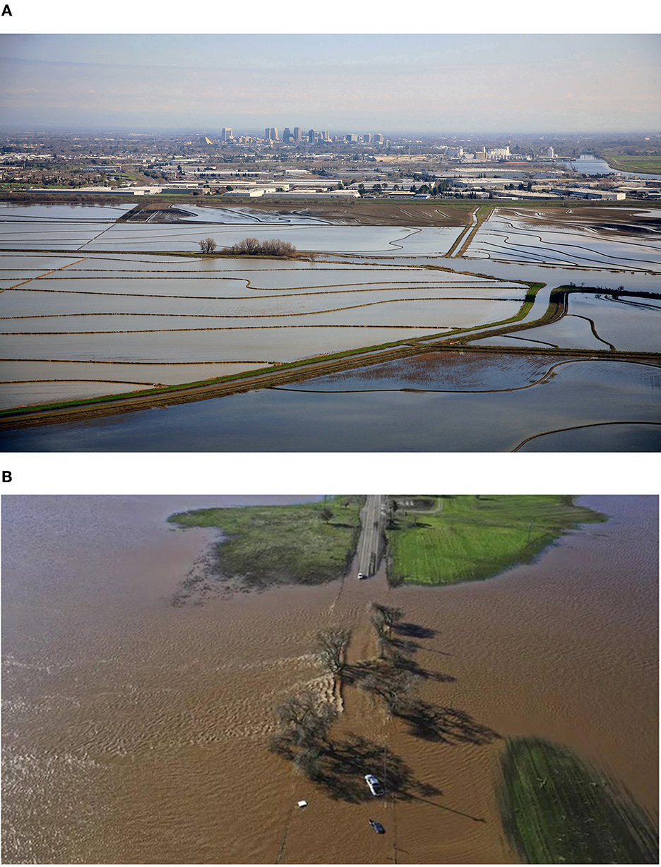
Figure 3. (A) View of flooding of the Yolo Bypass in the foreground, from the rainstorm-swollen Sacramento and American Rivers, near downtown Sacramento, California. Source: DWR. (B). Vehicles submerged on a road in south Sacramento County after a significant atmospheric river event in early January 2023 (AP photo) https://www.indiatoday.in/world/story/evacuation-orders-issued-northern-california-flooding-from-heavy-storm-2316586-2023-01-03.
3. Weather, precipitation trends, and sea level rise
An understanding of Sacramento's present day and future flood risk warrants an explanation of Sacramento's weather patterns and predicted effects of climate change. Sacramento has a Mediterranean climate that is characterized by mild winters and dry, hot summers. Nearly all the rain typically falls between November and March, often from large atmospheric rivers (NOAA, 2023), with the rainy season diminishing almost completely by the end of April. Average daily high temperatures range from the 50s degrees Fahrenheit in December and January to the 90s in July (with many days of over 100 degrees Fahrenheit); however, climate change models indicate a likely increase in average daily maximum temperatures by up to 10 degrees Fahrenheit by the end of the century (Houlton and Lund, 2018). Year to year variability in rainfall patterns is a feature of California' s climate but is expected to further increase according to climate change predictions. Though the average annual precipitation is expected to remain about the same, or increase only slightly, rainfall patterns will be increasingly variable over time. Dry years are likely to become even drier, while wet years will become even wetter in the next several decades (Dettinger, 2011; Yoon et al., 2015).
An increase in the intensity and frequency of extreme flood events may worsen flood problems in California (Florsheim and Dettinger, 2007). This trend has been noted in many regions across the globe, and greater precipitation variability and seasonal runoff are expected to result in increasing risks of flooding worldwide (IPC, 2023). By 2072, climate change is predicted to increase peak flood flows up to five times in the Central Valley compared to past recorded events (DWR, 2022a). Contributing to this pattern, an increase in temperatures will mean that storms will increasingly fall as rain vs. snow, further exacerbating the potential for flooding. This increased intensity of extreme storms makes it more likely that an extreme 1862-type of mega storm event could be triggered within the next 40 years (Dettinger and Ingram, 2013; Swain et al., 2014). Weather patterns in 2022 and 2023, illustrated these extreme weather fluctuations. A prolonged drought that lasted nearly uninterrupted for several years was followed by a record flood event on January 1, 2023, that caused rural levees to breach on the Cosumnes River, just southeast of Sacramento (Clift, 2023) (Figure 3B).
In addition to local weather changes, climate change models predict a feedback loop which is particularly problematic for flood risk. Global temperature increases in the next century will drive ice to melt at the poles, and thermal expansion of ocean water, both of which raise sea levels. It is predicted that end-of-century sea level rise (SLR) from the year 2000 in the San Francisco Bay area may be 2.5 feet (5th percentile) to up to 4.5 feet (95th percentile) (Pierce et al., 2018). Though Sacramento is inland, climate change and SLR are expected to affect water levels, putting more pressure on levees in the Delta (DWR, 2022a) and lower reaches of the Sacramento River by the turn of the century. A rise in sea level would also increase exposure to waves and wind set-up, increasing the pressure on the levees currently protecting low-lying land.
4. Flood management organizations and programs
Like most areas, the Sacramento Region relies on a complex array of entities that collaborate on levee maintenance and flood management. These include but are not limited to the United States Corp of Engineers, United States Federal Emergency Management Agency (FEMA), the Central Valley Flood Protection Board, the State of California Department of Water Resources, Sacramento County, City of Sacramento, and the non-profit local organizations that serve Sacramento and its neighboring counties, including the Sacramento Area Flood Control Agency, West Sacramento Flood Control Agency, Yolo County Flood Control Agency, and a wide array of local utilities. Many of the state and local organizations collectively depend on the federal government for financial and logistical support. In addition to various zoning and floodplain management ordinances, these entities coordinate and manage several grant programs and direct projects that accomplish a variety of flood management activities.
4.1. United States Army Corp of Engineers (Sacramento District)
The Division headquarters is in Sacramento; however, the Division's jurisdiction stretches from San Francisco east to Nevada and Utah. Historically with their support of the SRFCP, USACE has been the principal source of funding for most of the levees surrounding Sacramento. According to Public Law 84-99, the USACE may supplement the State, Tribal, Territorial and Local governments with flood preparedness and response services and advanced planning measures to reduce the amount of damage caused by flooding.
4.2. United States Federal Emergency Management Agency (FEMA)
FEMA is updating the nation's flood hazard data and maps, called Flood Map Modernization (FEMA, 2006). Through its flood insurance program, FEMA provides disaster assistance to individuals, families, and businesses whose property has been damaged or destroyed and whose losses are not covered by insurance (FEMA, 2023). FEMA has played an increasingly important role in funding flood risk reduction projects and projects that incorporate environmental approaches.
4.3. The Central Valley Flood Protection Board (CVFPB)
The Central Valley Flood Protection Board (CVFPB) was chartered in 1911 “to reduce the risk of catastrophic flooding to people and property within the California Central Valley.” It is the State regulatory agency responsible for ensuring that appropriate standards are met for the construction, maintenance, and protection of the flood control systems that protect life, property, and wildlife habitat in the Central Valley. CVFPB issues encroachment permits and works with other agencies to improve the Central Valley's flood management system (Central Valley Flood Protection Board, 2023). CVFPB is the State agency primarily responsible for ensuring the operation, maintenance, repair, replacement, and rehabilitation of existing facilities through its regulatory authority, and for working with U.S. Army Corps of Engineers (USACE) to develop flood damage reduction projects.
4.4. California Department of Water Resources (DWR)
DWR is responsible for leveraging state funding with federal and regional funding (through grants and other programs), to carry out a wide range of flood management activities including planning, research, and risk reduction programs and projects. DWR manages the California Data Exchange Center (CDEC) which installs, maintains, and operates an extensive hydrologic data collection network, and the Flood Emergency Response Information Exchange (FERIX) which provides on-line resources to improve flood emergency preparedness, response, and recovery in California (California Department of Water Resources, 2023). With the 2008 Central Valley Flood Protection Act, the State's legislature provided DWR the responsibility to prepare the CVFPP (DWR, 2022a). The CVFPP, which was first drafted in 2012, is updated every 5 years in accordance with the Act. The plan lays out strategies to:
• Prioritize the State's investment in flood management over a 30-year planning horizon
• Promote multi-benefit projects
• Integrate and improve ecosystem functions associated with flood-risk-reduction projects.
The CVFPP, updated in 2022, provides a comprehensive strategy that facilitates the identification of large-scale projects that provide flood risk reduction including ecosystem restoration for the State Plan of Flood Control (SPFC). The 2022 CVFPP estimated an investment need of $18–$23 billion over 30 years for one-time investments for the SPFC, and $350–$390 million per year for ongoing investments such as operations and maintenance (DWR, 2022b). Much of these funds are needed in the Sacramento Region for urban levee improvements. Since the adoption of the CVFPP, DWR has undertaken numerous flood management and multi-benefit projects that address fish and wildlife habitat restoration and recreation in addition to flood management in the Sacramento Region.
4.5. Sacramento County
The county plays an important role in flood management, as it regulates floodplain management through its zoning regulations with the statutory authority conferred upon counties by the California legislature (Senate Bill 5). A Floodplain management permit is required before any new construction, substantial improvements or other development begin in any flood hazard area (Sacramento County, 2017). Sacramento County also provides important flood risk outreach tools through their alert system, where stream level summaries, maps and flood scenarios are provided to help the layperson track and predict flood risks.
4.6. City of Sacramento
Given the City's high flood risk and vulnerability, the city developed a Comprehensive Flood Management Plan (CFMP) to guide the City's flood risk reduction and mitigation efforts from 2016- 2021. The City uses several tools for flood risk reduction including land use planning, emergency management, levee and other structural improvements, internal drainage improvements, risk communication to promote preparedness, national flood insurance, and levee security.
4.7. Sacramento Area Flood Control Agency (SAFCA)
SAFCA was formed in 1989, as a Joint Power Authority (JPA), to address Sacramento area's vulnerability to catastrophic flooding after the 1986 flood event by the City of Sacramento and surrounding counties and water districts (OPC, 2022). SAFCA plans and finances flood protection systems for the Sacramento Region. The agency is supported by residential and commercial assessments. Properties located in areas that benefit from projects are assessed on an annual basis for a fixed number of years to fund the local cost share (~10.5% of the total project cost). The agency works with other local and state entities to secure funding and implement projects for flood risk reduction in the region.
4.8. West Sacramento Area Flood Control Agency (WSAFCA)
WSAFCA, formed in 1994 through a Joint Exercise of Powers Agreement among the City of West Sacramento, Reclamation District 537, and Reclamation District 900, is working toward achieving 200-year level flood protection for the West Sacramento community by 2025 (WSAFCA, 2023a).
5. Flood risk reduction strategies in the Sacramento region
There are numerous complex classification systems to categorize flood risk reduction strategies (Zevenbergen et al., 2020); however, the various methods can be divided into three general categories, social/institutional (non-structural), traditional structural, and ecological based approaches (Table 2). This simple hierarchy was developed from observing the range of strategies utilized in the Sacramento Region and by evaluating preexisting frameworks (Hanak and Lund, 2012). This classification scheme provides a framework for discussion; however, it should be noted that many of these methods overlap, and some do not fit neatly into these categories. We summarize the approaches utilized in the Lower Sacramento Region, the progress made, and provide examples to illustrate these concepts to reduce flood risk. We chose to provide a more in-depth analysis of several projects, one that employs more traditional structural approaches and others that represent ecological based approaches that employ NbS, as both approaches are being tasked to provide additional long-term flood relief for Sacramento in the face of climate change. Because NbS projects generally require the most land area to implement, they are frequently the most challenging in urban areas. In the Sacramento Region, it is the collective combination of these structural and non-structural approaches combined into a comprehensive strategy, that will ultimately prepare for and protect the area from flooding, while enhancing resiliency.
5.1. Social/institutional strategies
Risk reduction strategies that focus on flood risk prevention and developing flood preparedness through education; and incentives, policies, and regulatory measures to prevent development in flood prone areas, are essential elements of a flood resilience strategy. These strategies are generally far less costly than building and maintaining infrastructure. These non-structural strategies range from more traditional “low tech” approaches such as information mailers and public workshops to on-line systems that provide on demand maps to convey flood risk. Many of these strategies also help to develop the social and political capital needed to develop and pass legislation to fund flood management projects.
Every fall, DWR mails notices to property owners in the Central Valley who are at risk of flooding and works with local county offices of emergency services to host meetings about the upcoming flood season, while providing resource materials and assistance (DWR, 2022c). Successful examples of on-line flood risk education include the City of Sacramento (City of Sacramento, 2023) and the Sacramento County's (Sacramento County Maps, 2023) flood zone maps (Figure 4), which provide in-depth information on where floods are expected to be most severe if there is a levee breach. These maps can be used to focus a community's awareness of their flood risk status and provide information on evacuations and safe havens should there be a flood. The City of Sacramento and Sacramento County both strongly encourage property owners within Sacramento to carry a flood insurance policy to protect themselves and their property, even if they aren't in a FEMA designated Special Flood Hazard Area (SFHA). DWR also hosts the “Flood Risk Notification website which provides Levee Flood Protection Zone (LEPZ) maps by address (as required by California Water Code 9130) (DWR, 2022d). The Flood Emergency Response Information Exchange (FERIX) developed by DWR also provides on-line resources to improve flood emergency preparedness, response, and recovery in California (DWR, 2022d).
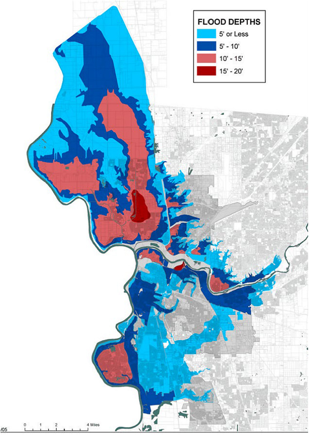
Figure 4. The City of Sacramento and nearby communities depend on the quality of its levees and surrounding bypasses. This graphic shows the ultimate flood depths if there were no levees. Note the potentially deep areas of flooding in the Natomas Basin in the north and pocket area in the south. https://www.cityofsacramento.org/Utilities/Drainage/Flood-Ready/Flood-Depth-and-Evacuation-Maps.
To prevent building in areas prone to high flood risk, it is important to have strong local zoning and building code regulations. However, despite Sacramento's flood history and known flood risk, the decision over whether an area should be developed, is not always clear-cut. The history of the Natomas Basin, a low-lying floodplain directly north of the Sacramento, developed from the 1950s provides an example of how flood zoning designations and public perception can change over time. In 1998, the levees surrounding the Natomas Basin (Figure 5) were certified by USACE as meeting the 100-year flood protection standard. FEMA designated the same area as “Zone X”—a moderate flood hazard area, which does not require the purchase of flood insurance. These designations allowed new development; however, 10 years later, new information and studies by the USACE caused the agency to decertify the levees, and the Natomas Basin was designated as a SFHA, the highest flood risk designation for any major urban area in the United States (SRRI, 2008). This has led to additional investment by the state and federal government to fortify and repair levees surrounding the Natomas Basin (see Case Study below).
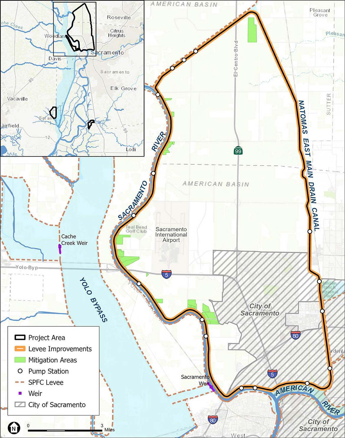
Figure 5. Natomas Basin Project Improvements are planned for a 42-mile ring levee around the Natomas Basin. The area encompasses a portion of the City of Sacramento and the confluence of several interstate transportation corridors. ESA with Esri and DWR input.
The Central Valley Flood Protection Act, enacted in 2008, aspired to go beyond the federal goal of 100-year flood protection, to achieve a 200-year level of protection standard for any urban area defined as a developed area with a population of 10,000 or more. The Act also provided the foundation for local programs to adopt new regulatory strategies to ameliorate flood risk. For example, in 2008, SAFCA implemented a Development Impact Fee (DIF) to ensure that new structures placed in the 200-year floodplain do not increase Sacramento's exposure to flood damages and the governmental costs associated with said flooding (SAFCA, 2023b). Collection of the DIF is administered by the City and County of Sacramento's respective Community Development Departments. Funds from the DIF Program are utilized to fund flood risk reduction projects to mitigate the additional property damage exposure created by new development.
In 2017, to protect human lives and minimize losses due to floods, Sacramento County began to require a “Floodplain Management Permit” before any “new construction, substantial improvements, or other development, including alteration of land, begins within any special flood hazard area or local flood hazard area either in the form of a permit or a formal improvement plan” (Sacramento County, 2017). A primary aspect of the permit is the requirement to build at least 1.5 feet above base elevations in flood hazard zones and to prohibit development that increases flood heights or velocities. The County also encourages improvements to existing structures in the floodplain, such as raising houses.
Despite changes in the policies affecting construction in floodplains, floodplain areas protected by levees are still subject to new development. For example, after the levees in the Natomas Basin were decertified, new development was largely curtailed, however, as the levees are brought up to a 200-year protection level, new developments are being proposed. Improvements which bring levees to a lower flood risk rating frequently result in lower insurance premiums and more complacency, which tends to spur additional development—the “levee paradox” (Smith, 2002, 2003). For example, the Upper Westside Specific Plan (Sacramento County Planning Projects Viewer, 2022), is a 2,083-acre development proposed in 2019 for the southern portion of the Natomas Basin in the unincorporated area south of the airport. Though the development proposes a new canal and pump structures to help mitigate impacts, the development, if it is approved, will still increase the number of residents living behind levees and risks posed by flooding.
California has the added problem, that because of its Mediterranean climate with long periods of drought, the public may lose interest in flood risk management, so it is important to utilize the large flood events as opportunities for education to convey risk and methods for flood preparedness, and maintain these messages over time. Sacramento County is working with local planning groups in small Delta communities on the outskirts of Sacramento through the “Small Community Flood Risk Reduction Program (SCFRRP)” (Sacramento County, 2022). Through this program, each community has a committee working directly with professionals to collect local knowledge and develop educational resources, to develop flood risk reduction alternatives. For each area, reports that review flood history, social and biological resources, and flood risk reduction strategies are available through an on-line portal (ESRI—story map tool) (Sacramento County, 2022).
New modeling tools are becoming more capable of providing visually accurate estimates of flood risk at various flood stages, which allows the public to better understand flood risk in their communities under different flood scenarios. These and other new research methods which contribute to education, project planning, and implementation are discussed in Section 6 below. However, despite the mailers, on-line tools, and informational meetings, physical warning signs of flood risk and posted evacuation routes (i.e., signs) in low lying at-risk communities are not abundant.
5.2. Structural approaches
5.2.1. Overview of types
Structural approaches to flood protection are heavily engineered features often consisting of levees, weirs, or dams. These features can be designed to last 50 years or longer with recurring maintenance and are critical to managing a flood system. By using these features, flood control systems have been developed throughout the nation, including the Sacramento Region.
5.2.2. Accomplishments, what has been built in the last 15–20 years?
As noted above, to help control the recurring flood risk in the Sacramento Valley, and as part of the State Plan of Flood Control, the SRFCP was created. The SRFCP consists primarily of six weirs and three flood relief structures, all designed with the knowledge that neither the riverbanks nor levees along the river could contain the runoff and that occasional spillover through the weirs and other flood relief structures would be necessary (DWR, 2010). The weirs function mostly by gravity to move floodwaters once the river surface water reaches certain elevations. The weirs feed the floodwater into bypasses and basins and reconnect with the Sacramento River near Knights Landing and Rio Vista (Figure 6).
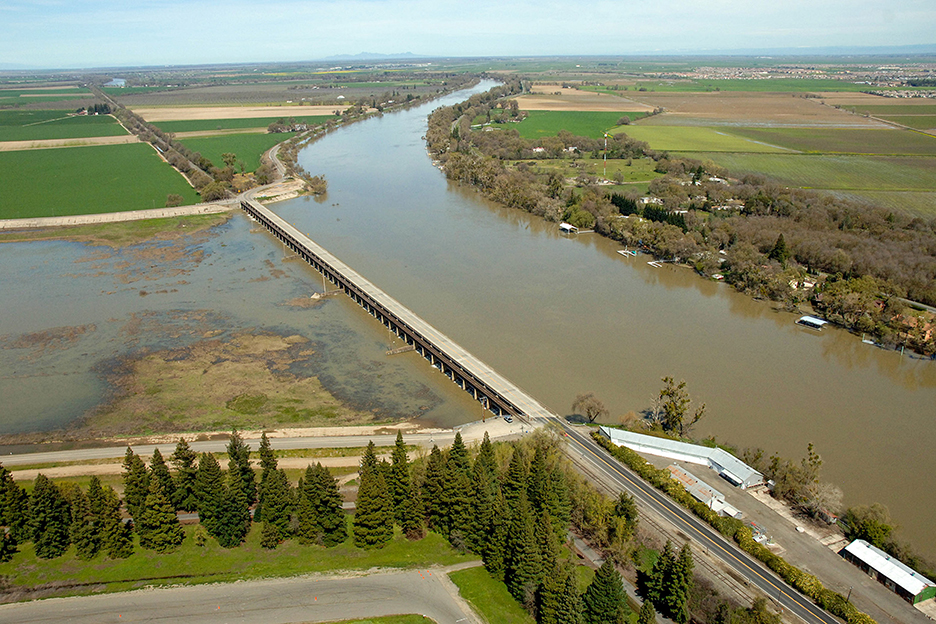
Figure 6. View of the Sacramento Weir, a key component of the Sacramento River Flood Control Project. The Sacramento Weir is located on the Sacramento River, is adjacent to the Yolo Bypass. DWR.
Sacramento's urban core is protected by numerous large levees with little room for floodplain expansion; so many levees must be repaired in place. Structural approaches such as levees resist floods, but because many of the early levees were constructed against the river's edge and became surrounded by development, there is no “room for error”. If one portion of these structures fails, entire communities are at risk. Significant flood events in 1986 and 1987 resulted in the need for robust improvements to the levees surrounding Sacramento (DWR, 2022c).
There has been significant progress in both securing funding and enhancing the SRFCP (DWR, 2023a). Historically, much of the funding for levee improvement came sporadically and was limited in focus; however, with the adoption of the 2008 Central Valley Flood Protection Act and completion of the 2012 CVFPP there was increased recognition that the State needed to enhance its financial contribution if the SRFCP historical structures were to be maintained and meet updated regulatory requirements. The 2022 CVFPP Update indicates that “approximately 33% of SPFC urban levees do not meet current levee freeboard, stability, or seepage design criteria at the design water surface elevation”, but that “a separate 30% of SPFC urban levees have been improved since 2017” (DWR, 2023a,c). Nearly all the improvements have been accomplished through partnerships. Common “Flood Partners” in the Sacramento Region include the USACE, the State of California including DWR, and either the SAFCA or West Sacramento Flood Control Agency (WSAFCA). Their leadership and efforts have included but are not limited to the following work.
5.2.2.1. Folsom dam and reservoir
The Folsom Dam was built in the 1950s to improve flood control along the American River. Improvements sponsored jointly by USACE, and the U.S. Bureau of Reclamation include a new dam and auxiliary spillway which allow dam operators more flexibility to manage flood storage (SAFCA, 2023c). The Flood Partners continue to increase flood control by working to raise the existing main dam and surrounding dikes by 3.5 feet, to help provide 200-year flood protection.
5.2.2.2. American river
Since 1998 the Flood Partners have coordinated to install cutoff walls, raise and stabilize levees, and reduce erosion risk to 25 miles of levee. Ongoing efforts include an additional 11 miles of levee erosion protection and will allow the lower American River to safely handle flood flows up to 160,000 cubic feet per second (SAFCA, 2023a).
5.2.2.3. Natomas basin
One of the most at-risk areas in the nation for flooding is the Natomas Basin (Figure 5) (USACE, 2023c). The Flood Partners have been steadily reducing the area's flood risk since 1996 (SAFCA, 2023d). Ongoing efforts include improvements to the 42 miles of levee that surround the basin with their completion allowing the levees to provide a minimum 200-year flood protection.
5.2.2.4. North Sacramento streams
The North streams include Dry Creek, Robla Creek, Natomas East Main Drain Canal/Steelhead Creek, and Arcade Creek. Levees and pump stations have been created, improved, and strengthened in areas since the 1990s to meet updated policies and standards. In 2018, SAFCA improved 3.75 miles of levee with its flood partners working to make additional improvements surrounding Arcade Creek and Magpie Creek (SAFCA, 2023e).
5.2.2.5. Sacramento weir and bypass
The Sacramento weir is located ~3 miles upstream of the confluence of the Sacramento River and American River. Its purpose is to protect the City of Sacramento from excessive flooding by diverting river floodwaters into the Sacramento Bypass and connecting to the Yolo Bypass. The Flood Partners have completed reconstruction of the southern levee of the bypass to address seepage and foundational issues (WSAFCA, 2023b) and are continuing work to widen the Sacramento Weir by constructing a 7-mile levee setback levee (SAFCA, 2023f; WSAFCA, 2023b). DWR is also expanding the capacity of the bypasses by constructing the Lower Elkhorn Basin Levee Setback (LEBLS) project (See Case Study below).
5.2.2.6. South Sacramento streams
South Sacramento County Streams include improvements to Morrison Creek, Elder Creek, Florin Creek, and Unionhouse Creek. The Flood Partners made improvements between 1996 and 2017 including 12.6 miles of floodwall, 7.7 miles of cutoff wall, 1.3 miles of new levee, 4.6 miles of levee raising, and 17 bridge retrofits (SAFCA, 2023g).
5.2.2.7. Sacramento river east levees
Composed of approximately 12 miles of levees from downtown Sacramento to the Town of Freeport, improvements have been continually made by the Flood Partners independently or collectively since 1990. Since 2019, the Flood Partners have addressed and continue to work on Embankment, foundation stability, and erosion issues in the area. To-date, ~ 9 miles of cutoff walls and 10 miles of erosion protection work and under development (SAFCA, 2023f).
5.2.2.8. Sacramento river west levees
Improvements by the Flood Partners independently or collectively include reconstructing and correcting seepage and erosion in several areas of the existing levee system and completing a 5.6-mile levee setback (Southport Levee Improvement Project) (USACE, 2023c; WSAFCA, 2023b). The setback levee significantly contributed to meeting updated Federal and State requirements by addressing seepage, stability, and erosion issues using cutoff walls, seepage berms, and rock slope erosion protection methods (USACE, 2023d).
5.2.2.9. Yolo bypass
The Yolo Bypass, a 59,000-acre engineered floodplain, is an essential part of Sacramento's flood risk management strategy (USBR, 2022). The Fremont weir which receives Sacramento River flood flows, has been modified to facilitate improved fish passage. Portions of the Yolo bypass levees have been improved and reconstructed to address erosion concerns (WSAFCA, 2023b). In addition, drainage facilities have been improved and contribute to reducing flood risk (California Department of Water Resources, 2023; USACE, 2023a).
5.2.3. Natomas basin levee improvements project (NLIP) case study
5.2.3.1. Overview and status
Historically, the Natomas basin was an active floodplain and occasional lake that occurred northeast of the Sacramento River and American River confluence. Due to nutrient rich soil resulting from recurring floods, the area was developed for agricultural use and levees were constructed to keep the floodwaters from destroying the newly developed lands (City of Sacramento, 2015). Today, the 53,000-acre Natomas Basin is surrounded by 42 miles of levee. In the 1990s, improvements consisted primarily of raising levees along the rivers, streams, and canal (SAFCA, 2023f). After the 1986 and 1997 flood events, the risk of floodwater seeping through or under the levees increased concerns that additional levee improvements would be needed. A 2006 study by the USACE confirmed these suspicions and concluded that the Natomas Basin had less than a 100-year level of protection from flooding (SAFCA, 2023d; USACE, 2023a).
Starting in 2007, SAFCA and the State of California started making levee improvements including cutoff walls, landside berms, and new adjacent levees. By 2013, ~18 miles had been improved and in 2019 USACE received Congressional funding to begin construction on the remaining 24 miles, in partnership with SAFCA and the State, to bring the level of protection to the Natomas basin up to Federal and State standards of a 200-year level of flood protection (SAFCA, 2023f).
5.2.3.2. Challenges and solutions
NLIP has encountered several challenges that highlight some of the complexities of implementing levee improvements. Real estate is perhaps one of the more challenging obstacles, especially given the levee's proximity to development and associated utilities. To meet current Federal and State flood protection standards several causes of flood risk need to be evaluated, including the risk of floodwater eroding a levee, seeping through or under a levee, overtopping a levee, among several other potential risks. In the case of NLIP, and similarly constructed levees, additional or modified real estate is needed to implement the engineer-designed protection. As an example, the Reach A portion of NLIP includes a 3.5-mile levee improvement feature consisting of widening the existing levee, installing a seepage cutoff wall, and building a landside seepage berm (USACE, 2023c). To accomplish these improvements additional land is needed, and all existing easements, including utilities, roadways, or other impediments, need to be relocated or negotiated to not impact the ability of the levee maintainer to operate and maintain the levee.
Another issue common to levee improvement projects that NLIP has experienced is securing funding. Agencies that fund flood risk reduction projects will each have their own method for evaluating the costs and benefits of a project. These methods are influenced by the source of funding, agency priorities and policies, and regulatory considerations, among other factors. In addition, funding can also be limited to specific actions, such as a feasibility study, design development, construction, or maintenance. The cost of completing the construction of NLIP is approximately $1.2 billion, however NLIP would increase protection to ~100,000 people, $7 billion in assets, and 53,000 acres of land (Central Valley Flood Protection Board, 2023; USACE, 2023c).
Despite these improvements, the very low-lying areas are still at risk of flooding if the drainage canals and pumping stations were to fail. In early January of 2023, after weeks of rain and an electrical outage, the area very nearly flooded (Haefeli, 2023).
5.2.4. Ecological based approaches
Flood risk reduction projects that employ methods that support ecosystems in addition to benefitting people, are multi-benefit projects that employ NbS. The International Union for Conservation of Nature (IUCN) pioneered the concept of NbS at least 20 years ago, as “actions to protect, sustainably manage, and restore natural and modified ecosystems that address societal challenges effectively and adaptively, simultaneously benefiting people and nature.” (IUCN, 2021). FEMA has adopted this concept for providing solutions that reduce the effects of natural disasters (FEMA, 2021) and USACE has adapted the concept for their water infrastructure projects in limited situations, using the term “Engineering with Nature” (Bridges et al., 2018). These methods are also described as “natural flood management” or “integrated flood management” (World Wildlife Fund, 2017). A multi-benefit project accomplishes two or more intended outcomes and is usually the result of collaboration among water management sectors, is multi-disciplinary, and leverages multiple funding sources (Serra-Llobet et al., 2022b; Maven's Notebook, 2023). Below (Section 5.3.2) we review multi-benefit projects that are applying these principles to reduce flood risk by reconnecting rivers with their floodplains and tidal wetlands.
5.2.5. Reconnecting rivers, floodplains and tidal marshes
The low-lying land on either side of a river's banks makes up a river's floodplain, the area that is covered in water when a river “floods” or overflows its banks. Floodplains form from the erosion and deposition that occurs as a river meanders down a valley (Opperman et al., 2010). Over time, the height of the floodplain increases as material is deposited on either side of the river during floods. Eventually this increase in land elevation, becomes a natural levee along the floodplains edge, and in some cases provides a drier upland area that more easily supports human settlement. In Sacramento and the surrounding Delta, natural levees were often used as the base for building higher artificial levees as these areas with rich alluvial soils were “reclaimed” for agriculture. In many cases, to build these levees, soil was removed from the surrounding landscape, creating even deeper areas just outside of the landside levee tow (DWR, 2009). These artificial levees inhibit lateral connectivity with the surrounding landscape and have been associated with negative impacts to ecosystems (Wohl et al., 2021).
The conventional viewpoint has been to consider floods as a risk to communities; without accounting for the beneficial aspects of floods to provide benefits to ecology and water supply (Galloway, 2005). In fact, over time in the United States, the term floodplain became synonymous with a more regulatory definition, which referred to the extent of the area inundated during a specific flood frequency (such as the 100-year floodplain) (Serra-Llobet et al., 2022a). However, in addition to providing space for rivers to flow and alleviating flood risk, intact floodplains can also support thriving ecosystems, riparian forests, and seasonal marshes, that in turn support a wide range of native species (Serra-Llobet et al., 2022b). Restoring floodplains can also facilitate groundwater recharge as flood waters remain on adjacent lands (Maples et al., 2019). As levees collapse and create flood risks and potential societal harm, there is increasing realization that reconnecting rivers with their floodplains, can address multiple issues and provide both ecological and sociological benefits (Pugliese et al., 2020).
Floodplains are dynamic systems, characterized by complex water and sediment interactions within a complex landscape, constantly changing with each flood event (Opperman et al., 2010; Serra-Llobet et al., 2022b). Research on a floodplain ecosystem created by an accidental breach along a tributary of the Sacramento River, the Cosumnes River, lead to a deeper understanding of the importance of these systems to fish and wildlife (Florsheim and Mount, 2002; Jeffres et al., 2008; Nichols and Viers, 2017; Thaler et al., 2023). Fisheries research in the Yolo bypass during and after flooding, further illustrated how these shallow connected areas with enhanced productivity can nourish fish leading to enhanced salmon growth rates and viability (Sommer et al., 2001; Takata et al., 2017).
Because Sacramento lies at the riverine-Delta interface, its surrounding bypasses provide the potential to restore tidal freshwater marshes in addition to low lying floodplains. Depending on the season, the tidal influence can extend inland 90 miles as far as the City of Sacramento and the areas surrounding Sacramento are influenced by both daily tidal fluctuations and seasonal flooding. During the flood season, if the natural riverine floodplain interface is restored, floods drown out the tidal signal and floodplain ecosystems are dominant. However, during the summer, these same areas can be dominated by tidal forces and freshwater tidal marshes support local flora and fauna. These areas support juvenile Chinook Salmon and Steelhead that migrate from their spawning grounds along the Sacramento River and tributaries.
5.2.6. Multi-benefit project case studies
Projects that create and enhance flood basins near Sacramento provide opportunities to incorporate riparian floodplain and tidal marsh restoration, and enhance areas for water quality and supply, fish and wildlife, and human societal values such as recreation, agriculture, and flood risk reduction. Successful examples of setback levee creation for floodplain and tidal marshes nationally and internationally have provided the knowledgebase for the projects constructed in the Sacramento Region (Maples et al., 2019; Bridges et al., 2020; Guerry et al., 2022; Serra-Llobet et al., 2022b). In the past several years, concept development and planning have finally come to fruition. Each of these multi-benefit project examples are in early phases of implementation. Challenges can be encountered in nearly every phase of project development, from the issues surrounding land acquisition and the ability to change existing land use practices to human social, cultural and political dimensions, funding, permitting, construction and long-term maintenance. Due to the size and complexity of most multi-benefit projects, the challenges are substantial, and the solutions offer insights that can inform the design of future projects in this region as well as other locations.
5.2.6.1. Lower Elkhorn Basin Levee Setback Project
Overview and Status: The Elkhorn Basin, is in Yolo County, west of the Sacramento River, and the City of Sacramento, and adjacent to the Yolo and Sacramento bypasses which are part of the area's systemwide flood protection infrastructure. The bypasses provide flood relief to residents along the Sacramento River, and levees separate the bypasses from the river except along two low stretches, the Sacramento Weir, and Fremont Weir. When water levels are high, the pinch points along the river south of the weirs cause the flows to back up, water levels rise, and overtop the weirs. Operators can lower the Sacramento Weir and allow more water to enter the Sacramento bypass by removing flash boards (Figure 6). There is a potential to improve on and expand these bypass areas, and the Lower Elkhorn Basin Levee Setback (LEBLS) Project is one such project.
The LEBLS Project widens the Yolo and Sacramento bypasses between Interstate-5 and Interstate-80 in Yolo County (Figure 7), through a partnership between DWR, USACE, CVFPB, SAFCA, and local reclamation districts (DWR, 2023d). It is a multi-benefit project, providing flood benefits for the greater Sacramento area, while protecting local agriculture and providing beneficial habitat for fish and wildlife. The project is expected to improve public safety for approximately 780,000 people by reducing river levels (stages) in the Sacramento River and increasing the capacity of the Yolo and Sacramento Bypasses near the urban communities of Sacramento and West Sacramento, as well as surrounding rural communities, Woodland, and Clarksburg. The improvements will also provide system resiliency and opportunities to improve ecosystem functions, such as increasing inundated floodplain habitat for fish rearing, and avian use.
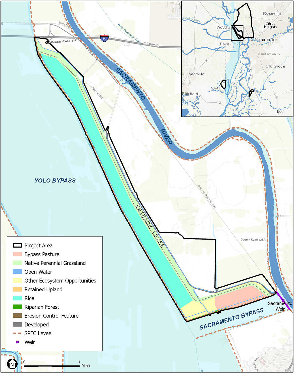
Figure 7. Project location map and design for the Lower Elkhorn Basin Levee Setback (LEBLS) Project. The project consists of setting back five miles of the east levee of the Yolo Bypass and two miles of the north levee of the Sacramento Bypass and degrading the existing levee. ESA with Esri, GEI, and DWR input.
The project consists of setting back five miles of the east levee of the Yolo Bypass and two miles of the north levee of the Sacramento Bypass and degrading the existing levee (GEI Consulting Engineers Scientists, 2019). When the area floods, the expanded bypass area will provide an additional 900 acres of seasonal wetlands, providing additional forage and shelter for waterfowl migrating along the Pacific Flyway. The setback levee along with other Yolo Bypass improvements will benefit salmon, sturgeon, and the endangered Delta smelt by expanding available floodplain habitat.
Challenges and Solutions: The expanded bypass area must not only handle high-water events, but also support native plants and wildlife as well as recreational uses and water supply storage. At the onset of planning for Yolo Basin modifications, the issues were at times contentious. The Yolo Basin Foundation initiated the Yolo Bypass Working Group in 1998 under a CALFED Ecosystem Restoration Grant (Yolo Basin Foundation, 2023). This ad hoc stakeholder group became a successful forum to discuss issues and potential solutions and continues to meet as needed. Over 40 people representing a wide range of stakeholders with an interest in the Yolo Bypass regularly attend these meetings. This and other forums of outreach such as the California Environmental Quality Act (CEQA) process eventually led to a viable project alternative.
The Yolo Bypass and surrounding area is known for its importance to salmonids and other special status fish species and is part of the Pacific Flyway which provides invaluable foraging habitat for migrating birds. Swainson's hawk is a locally prevalent but threatened species regulated by the California Department of Fish and Wildlife. The giant garter snake is also found in this region, and hibernate near levees, so implementation must be planned during certain construction windows to avoid impacts to these species. These species and their specific life histories were carefully evaluated and considered in designing the LEBLS Project (DWR, 2021).
One of the LEBLS project's largest challenges was the quality and amount of soil moving to construct the setback levee (Kilpatrick, 2021) (Figure 8). Approximately, five million cubic yards of earth will be moved over more than 700 acres of land. Much of the area is composed of “fat clay”, a slippery sticky clay that wouldn't ordinarily meet the USACE's standards for levees; however, trucking in millions of cubic yards of more suitable soil would have driven up the already substantial costs of the project and exceeded the project's emissions standards. To accommodate this clay, the existing narrow 100-year-old levee, with its more common 2-to-1 or 3-to-1 side slopes, is being replaced with wider levees (28 ft) with shallower side slopes (4-to-1). The drought conditions during the last several years has further exacerbated construction plans as it was necessary to wet the soil to move and manipulate the soil.
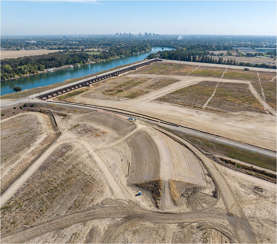
Figure 8. This photo illustrates the substantial earth moving required by the Lower Elkhorn Basin Levee Setback (LEBLS) Project. Photo by Florence Low, October 19, 2022, DWR.
Once the area is flooded, the levees need to resist levee erosion from wind-wave action. The LEBLS levee's designers needed to consider erosion control, due to the region's strong southwesterly winds. Placing rocks to protect the levee sides wasn't deemed an effective strategy because new invasive vegetation would cause environmental and operational problems. A concrete-block mat product was chosen to protect the levees and provide a better surface for planting low maintenance perennial native grasses. Test plots were planted to ensure that this method would be effective. Due to the project's scale and schedule, the ability to acquire large quantities of native seed and supplies in a timely manner was also a particularly challenging aspect of the project.
5.2.6.2. Lookout Slough Project
Overview and status: Located in the Sacramento-San Joaquin Delta and adjacent to the lower portion of the Yolo Bypass, the Lookout Slough Tidal Habitat Restoration and Flood Improvement Project (Figure 9) creates new flood capacity in the lower Yolo Bypass by constructing a 25-foot-tall setback levee that will expand the Yolo Bypass and create an additional 40,000 acre-feet of flood storage (ESA, 2020). The 3,400-acre site of former farmland and duck hunting grounds west of the Yolo Bypass, lies at the interface of the floodplain and tidal range, and provides opportunities to create a range of habitat types spanning from subtidal to upland elevations. The area is slated to become one of the largest freshwater tidal wetland restoration projects in California, providing habitat and food for Delta Smelt, Longfin Smelt, Chinook Salmon, Green Sturgeon, Steelhead, and other fish and sensitive species known to the region. There will also be recreational opportunities at the site, as the public may access the new tidal channels by boat for wildlife viewing, fishing, and hunting. Construction of the Project began in May of 2022 and is expected to be completed in 2024.
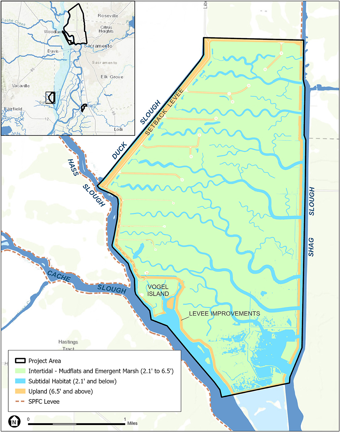
Figure 9. Project location map and design for the Lookout Slough Tidal Habitat Restoration and Flood Improvement Project. Major design features include constructing the new Duck Slough Setback Levee, constructing over 20 miles of new tidal channels, and breaching the Shag Slough Levee and an agricultural berm along Cache and Hass Sloughs to restore tidal action to approximately 3,160 acres. ESA with Esri, EIP, and DWR input.
By excavating open tidal channels and providing appropriate intertidal elevations for the recruitment of natural vegetation, the Project will create approximately 3,200 acres of subtidal, tidal marsh and upland riparian habitat. The new 3-mile setback levee parallels the northwestern and northern perimeter of the site and will become part of the State-Federal levee system and become the west levee of the Yolo Bypass. The existing west levee of Shag Slough and the Yolo Bypass will be breached at nine locations to provide hydraulic connectivity and restore normal tidal exchange to most of the site. The remainder of this existing levee would be left in place, with riparian vegetation planted along its perimeter. The northern and southernmost 1,500-foot segments would be degraded to match the elevation of approximately the ten-year storm event to act as an inlet and outlet for flood overflows from the Yolo Bypass onto the Project Site when it is activated, providing flood storage and conveyance benefits.
The Project creates over 20 miles of new sinuous tidal channels that range in size up to 600 feet wide, with depths of approximately 2 to 6.5 feet of water depending on the natural tidal cycle. Adjacent tidal marsh will be inundated daily by tides and will naturally colonize with native tidal habitat including tule (Schoenoplectus acutus var. occidentalis). Approximately 42 acres of adjacent upland habitats associated with remnant levees, including the improved Cache/Hass Slough Training Levee, and newly constructed PG&E access roads to a series of high-voltage transmission towers, will be bordered with planted trees including oak, walnut, ash, and valley elderberry. The proposed tidal habitat will support food web productivity within the Project Site and the adjacent Cache Slough Complex, providing both regional food web benefits and additional slow-velocity tidal habitat for native fish rearing. The federally- and state-threatened giant garter snake will also benefit from the restoration, as they have evolved along the margins of tidal marshes, and the Project has incorporated design features that benefit this snake including flood-protected winter refugia habitat west of the new levee for this species to hibernate (WRA Environmental Consultants, 2019). The conversion of these lands back to a natural tidal ecosystem with riparian habitat will also offer benefits to other species of the region including the valley elderberry longhorn beetle, western pond turtles, migrating birds and marine mammals.
Challenges and solutions: Funding a project of this magnitude is a challenge; however, the flood and restoration benefits allowed the Project to secure funds from multiple sources. Levee setback projects frequently take years of planning; however, the Lookout Slough Project is unique in that it provides an example of how an innovative public-private partnership (in this case DWR/Ecosystem Investment Partners [EIP]) can accelerate project delivery (DWR, 2022d). As a private company, EIP can purchase private properties more quickly than State agencies, including three properties comprised of 3,400 acres of mixed land uses including irrigated pasture and a private duck club. The Project demonstrated the value of working closely with the existing agricultural lessee who would be displaced by the Project's footprint. EIP improved a neighboring parcel that was leased to the previous tenant farmer and funded improvements to allow the lessee to maintain the same level of agricultural productivity (Lookout Slough DEIR 2022). In addition, EIP recorded conservation easements over ~1,000 acres of irrigated pasture in the vicinity of the Project, permanently protecting agricultural values while also providing protection to Swainson's hawk foraging habitat value that such land offers, a win-win solution.
Utilities, gas lines, and other infrastructure can be significant obstacles for creating tidal and floodplain habitat that is periodically or permanently inundated. The Lookout Slough Project required significant planning and negotiations with utility companies as various PG&E infrastructure was removed, relocated, or preserved, depending on their function. Figure 9 depicts the higher elevation areas with roads that were created to provide access to PG&E transmission lines when the area is inundated. Buildings, sheds, barns, fences, posts, the structurally deficient Shag Slough Bridge, concrete pads and any other such materials within the construction footprint were demolished and hauled to a nearby landfill or used on-site, as appropriate. Each of these activities was included in air quality and greenhouse gas emissions estimates and considered through a variety of permits.
Large earth moving projects such as Lookout Slough, which will move over 5,500,000 cubic yards of dirt to construct the design features, require several years to complete (Figure 10). Construction at this scale must be carefully considered and planned during development of environmental permits to maximize efficiency and constructability, while simultaneously achieving environmental protections during earthmoving operations. EIP navigated this process by including their restoration contractor, who would ultimately complete the earthwork, in permit negotiations to understand in real time the ramifications to construction duration and associated temporary disturbances to species that permit conditions could have for the Lookout Slough Project. The Project team also worked with regulatory agencies to determine the best phasing approach for construction to minimize potential temporary indirect impacts to sensitive species. For example, the site was dewatered in a phased approach prior to major earthwork occurring so that sensitive species that depend on the interface of terrestrial and aquatic features would follow the water as it drained outside of the active work area. A temporary rescue and relocation area was then established to provide interim habitat during the construction season for these species. Further, to minimize disturbance to nesting birds, vegetation removal and initial ground disturbance occurred outside of the general nesting bird season in areas where earthwork was planned, to reduce habitat suitability for nest establishment during the nesting season.
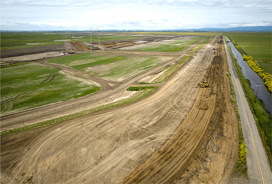
Figure 10. Construction vehicles work on the new 3-mile Duck Slough Setback Levee on the northeast side of the Lookout Slough Tidal Habitat Restoration and Flood Improvement Project within the southern part of the Yolo Bypass on May 5, 2023.
5.2.6.3. McCormack-Williamson Tract Project
Overview and status: DWR is pursuing the McCormack-Williamson Tract Levee Modification and Habitat Restoration Project (MWT Project) with Reclamation District 2110 in the northeast Delta, immediately downstream of the confluence of the Cosumnes and Mokelumne Rivers, south of Sacramento. The MWT Project has a long history as it was conceived in the early 1990s to help solve flood risks in the northeast Delta through an extensive stakeholder engagement process which included agency representatives and neighboring landowners. The North Delta EIR including the MWT Project was certified in 2010 and recertified through a supplemental EIR in 2022 (DWR, 2023a). The 1,650-acre agricultural tract has the potential to provide flood relief to a large and sparsely-populated rural community, north of the project site. Flood flows and high-water conditions threaten levees, bridges, roadways, farm structures and some private residences.
The MWT Project (Figure 11) is designed to allow the passing of flood flows through the tract, in a way that minimizes regional flood risks. Though the land is not deeply subsided, the project still requires substantial earth moving to reach its tidal and riparian habitat goals and is designed to maximize process-based restoration and natural recruitment (Figure 12). It will benefit aquatic and terrestrial habitats, ecological processes, and species, as it incorporates landscape-scale restoration of Delta habitat. The plan is to restore up to 900 acres of tidal freshwater marsh and nearly 300 acres of floodplain and upland riparian habitat. The tidal marsh and shaded riverine habitat areas will provide habitat and enhance productivity for juvenile Chinook Salmon and Steelhead while migratory birds, turtles, and giant garter snakes will utilize those habitats as well as restored riparian and transitional upland habitats.
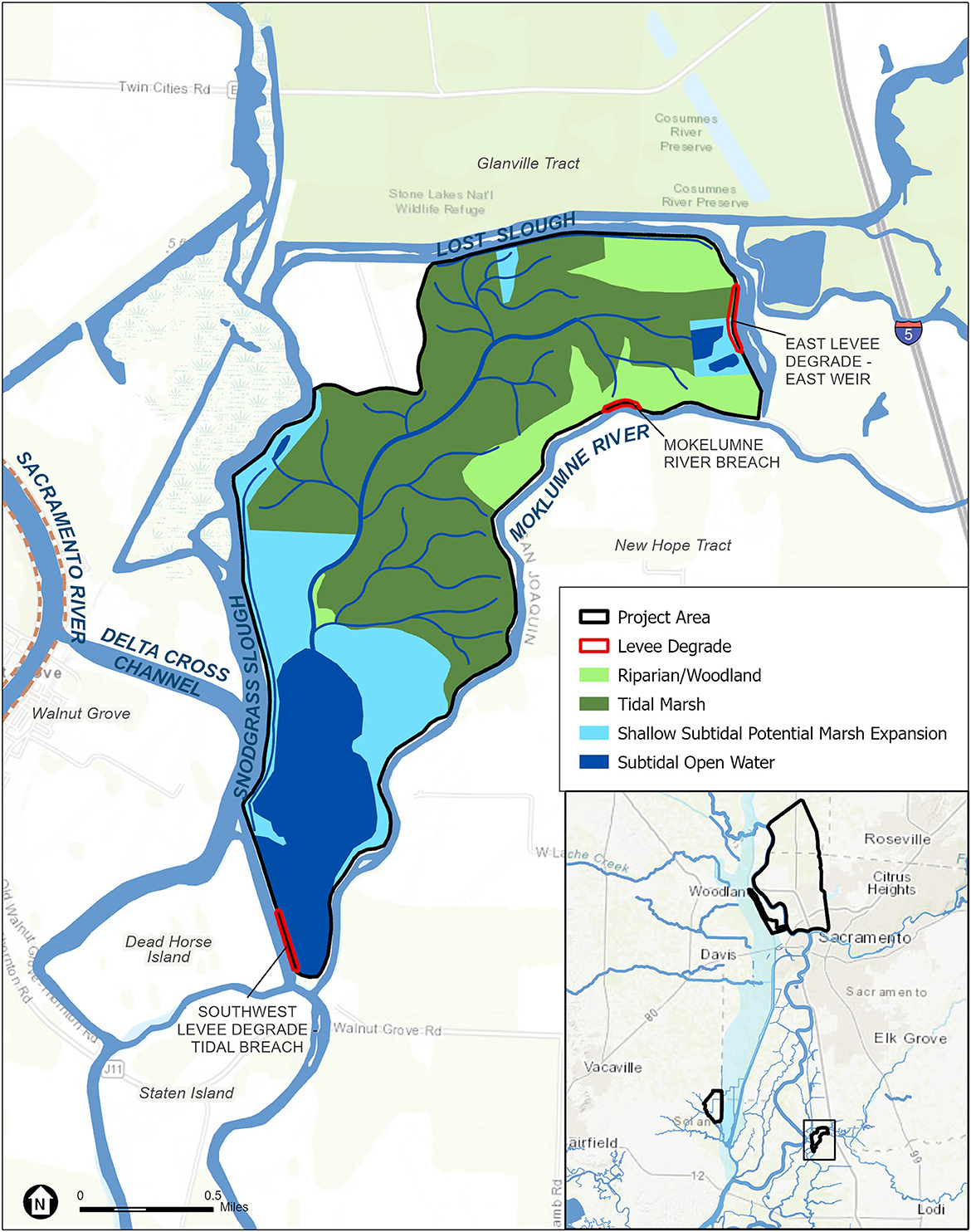
Figure 11. Project location map and design for the McCormack-Williamson Tract Project. Major design features include the northeast weir and Mokelumne River breach which will allow flood waters to enter the tract and alleviate flood risk south of Sacramento. ESA with Esri, GEI, and DWR input.
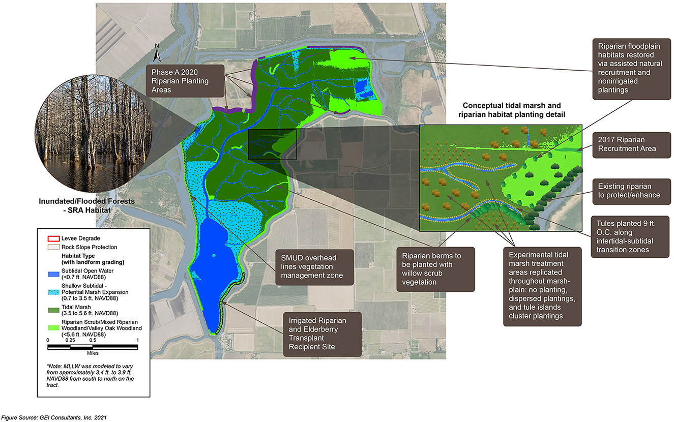
Figure 12. McCormack-Williamson Tract Project Restoration Plan showing the importance of process-based restoration and natural recruitment to reestablish floodplain riparian and tidal marsh habitat. Jennifer Burt, GEI Consultants.
Due to ongoing concerns about flood risk and liability, the MWT Project was separated into two phases. The first phase, constructed in 2018–2019, consisted of work on the MWT interior, including constructing a ring levee to protect a communications tower in the northwest corner of MWT; demolishing old buildings and infrastructure; removing mobile tanks with potentially hazardous materials; enhancing the landside slope of levees to provide a bench for wind wave attenuation and vegetation plantings. The second phase, planned for implementation from 2023 to 2026, consists of degrading a portion of the tract's northeast levee to function as a weir, breaching the Mokelumne River levee, degrading a portion of the tract's southwest levee to match the elevation of the island floor, and modifying landside levee slopes and agricultural lands to create floodplain riparian and tidal marsh habitat.
Challenges and solutions: MWT Project's planning history illustrates the difficulty and time necessary to implement many large multi benefit projects. Though the EIR was certified in 2010, the planning, modeling, and permitting timeframe has been protracted due to changing funding priorities, regulatory issues, the sites' location, and ongoing flood risk. At the onset of planning, DWR did not have a long history of developing multi-benefit projects and the funding priorities and programs under which the project was planned have changed over time.
The project also demonstrates the importance of taking a systemwide perspective when planning projects and the importance of hydrologic research/modeling to support planning. The area is on the edge of the tidal zone and far from downstream pumps that are part of the State Water Project and Central Valley Project that carry freshwater to Southern California. However, the site's location adjacent to the Delta Cross Channel, a conduit for bringing freshwater into the interior Delta, led to questions about whether the project could influence salinity intrusion from the San Francisco Bay. This possibility was not appreciated during early planning efforts and so it became necessary to provide updated hydraulic models and that and other changes caused the project team to recirculate the CEQA document to support the project.
California's regulatory setting is complex and challenging to navigate. Projects that are changing a reclaimed agricultural landscape to tidal marsh, result in a heavy mitigation load because of the possible effect these projects have on the native species (e.g., Swainson's hawk) that have become adapted to agricultural environments. Even though “restoration and enhancement of native habitats” is a primary goal, the project does not receive any “lenience” in terms of environmental permitting. Until recently, restoration projects received the same treatment as development projects under existing California laws; however, there are efforts working to streamline permitting for these projects (Sustainable Conservation, 2023). Most projects affecting waterways are also required to obtain encroachment permits from the Central Valley Flood Protection Board and Streambed Alteration permits from the CDFW. In recent years, CDFW has begun to expand its regulatory jurisdiction into habitats occurring on the landside of levees for some SAA permits, resulting in higher mitigation requirements (Maven's Notebook, 2016).
Building projects on subsided lands that are also active flood zones is problematic. As one of the last islands to be reclaimed in the Delta, MWT Levees were left lower than surrounding islands due to some early agreements to provide flood relief for areas upstream. The tract has flooded numerous times, and in most cases, the breach occurs at the northeast corner along the North Mokelumne River, the tract rapidly fills and causes an uncontrolled breach in the downstream levee, providing a catastrophic “surge” effect that can affect downstream properties. MWT flooded in 2017 just prior to the construction of Phase A and again in early 2023, while the final phase of the project was in final permitting and design to begin construction. Without reclamation and significant earthwork, much of the tract would support permanent shallow open water habitat, with elevations too low to support riparian and marsh vegetation. After each flood event, the project sponsors have needed to determine whether to repair the breaches, drain the island, and perform fish rescue operations for the project to proceed. These activities have added to project costs and CEQA and permitting issues that further complicated project delivery.
6. Advances in research supporting flood risk reduction projects
Data-driven, multi-disciplinary research provides the underpinning for sound flood risk management strategies. Without advances in our understanding of climate, weather patterns, hydrology, geomorphology and development patterns and social institutions, a flood manager is limited in their ability to predict flood risks and prepare appropriate management responses. Nearly every flood risk reduction program and project utilize advances in hydrologic modeling and mapping approaches. Modeling tools such as DWR CalSim, CVFED, CVHS, and HEC-RAS) (USACE, 2023b) and the methods to illustrate and disseminate results have improved greatly over time. DWR manages the California Data Exchange Center (CDEC) which installs, maintains, and operates an extensive hydrologic data collection network, including automatic snow reporting gages and precipitation and river stage sensors for flood forecasting (DWR, 2022d). Early snow survey techniques required manual sensors but now information can be collected remotely and models that interpret satellite or drone imagery are providing a more comprehensive spatial picture of snow cover (DWR, 2023e). DWR along with federal and local water agencies, have developed a Forecast-Informed Reservoir Operations (FIRO) program (Center for Western Water and Extremes, 2023) that takes advantage of scientific improvements in forecasting atmospheric rivers to better anticipate and manage their response to large storm events. Through its Flood Operations Center (DWR, 2023b), DWR utilizes its collective models and measurements to assist in dam operations. By encouraging communication and providing forecasting tools, dam operators can better coordinate their responses, thereby reducing potential flood risk and providing more flood resiliency on a regional level.
7. Discussion
The passage of the 2008 Central Valley Flood Protection Act and adoption of the 2012 CVFPP, that created a plan and focused the state's attention on flood risk management, was a significant achievement. The updates in 2017 and 2022 represent the state's ongoing commitment to provide a reliable funding strategy, guide implementation, and track the progress made in planning and implementing projects that provide sustainable solutions to reduce flood risk in the state, including the Sacramento Region. The many organizations working together to inform and educate the public, gain a better understanding of stakeholder concerns, and provide solutions that address these concerns, demonstrates the region's coordination and commitment for building flood resilience.
The Lower Sacramento Region represents only a portion of California's overall progress in addressing flood management, however, this review helps illustrate the State's overall commitment to ameliorating flood risk and is important because of Sacramento's place as the state's capital, urban population center, and its extreme flood risk. The area is a microcosm of global problems due to urbanization in flood zones and the intense pressure faced to protect these areas in the face of climate change. This review also illustrates how the reduction of flood risk, must take into consideration, not only the immediate urban area, but the communities and even rural areas surrounding it. It also emphasizes how important it is to understand an area's flood history and past planning and accomplishments to forge a path for the future.
As a basis for discussion, we have categorized flood risk reduction activities into three broad categories, social/institutional (non-structural), traditional structural, and ecological based NbS approaches. As we have discussed these categories, it is apparent that a range of project types are critical for a comprehensive regional approach for reducing flood risk and increasing resiliency. Social/institutional (non-structural) approaches are essential for building the political and financial support for implementing structural improvements and they are also essential for providing the education needed to prepare communities for floods, should they occur.
Though informational tools are numerous and provided by many of the flood management organizations, particularly through web-based programs, it is difficult to verify that residents understand the implications of these messages, until there are active flood events such as the recent floods of January 2023. Despite this, there are some local examples of outreach that appear to be highly successful. Outreach conducted through local consortiums such as the Yolo Basin Workgroup and Sacramento County's “Small Communities Project” illustrate the importance of utilizing the knowledge of local landowners to develop projects that have stakeholder support. In addition to educational and outreach programs, since the 2008 CVFP Act, local policies and regulations are being adopted to support flood risk reduction. However, despite the known flood risk for many Sacramento communities due to their location on historic floodplains, local regulations may not be restrictive enough to inhibit additional development in areas that are protected by levees. Levee repair projects reduce the likelihood of flooding; however, the concomitant changes in mapping designations also tend to increase public complacency and the likelihood that more people will build in these areas, increasing the population potentially affected and damage costs if levees fail. The “levee paradox” is a common feature of flood risk management in both California, the nation, and other international settings.
Structural improvements have been enabled through federal support, the influx of California bond funding for structural projects, recent allocations targeted at urban flood risk reduction, and deferred maintenance (DWR, 2022d). These projects depend on the collaboration of both federal, State, and local agencies and organizations. Overall, since 2007, at least 80 miles of urban levee have been repaired, rehabilitated, or improved, in the Lower Sacramento Region. Traditional levee improvements are increasingly expensive as new environmental regulations and structural methods have evolved; however, their durability has improved, providing more sustainable and resilient structural impediments to flooding than in previous efforts.
During the last century, policies and projects tended to focus on rebuilding levees in place to minimize flood risks instead of utilizing more holistic approaches that maximize a variety of social and ecological benefits (White et al., 1992). Building on the experience and success of multi-benefit projects implemented elsewhere (Schindler et al., 2014; Golfieri et al., 2017; DWR, 2022d; Serra-Llobet et al., 2022b), an increased understanding of the threat of climate change, and the value of existing flood bypasses for natural resources, there is more emphasis on developing multi-benefit projects in the Sacramento Region. These projects employ NbS to create new habitat, such as floodplain and tidal marshes, but also provide flood volume capacity, thereby improving the existing Sacramento River Flood Control Project (SRFCP)'s ability to manage flood risk. Though at the state level, there is an increasing focus on building multi-benefit projects, their execution is still in its infancy, and each of these case studies represent projects in their early implementation phases, after long planning horizons. Multi-benefit projects can include exacerbated challenges often due to large changes in land-use, land acquisition and existing easements, funding, permitting, and construction. The examples provided illustrate a wide variety of common and sometimes unique solutions to these problems. There are efforts to streamline permitting and modify how flood risk reduction projects are implemented to facilitate faster project delivery. These examples also provide insights and highlight the need for future long-term monitoring of project outcomes to assist other project managers and planners in their efforts to implement large structural or multi-benefit projects in other locations.
Advances in research, including ecological research, have provided an essential foundation for realizing improvements in flood management including multi-benefit projects that also support native species. Advances in hydraulic/hydrologic modeling and mapping approaches support communication with the public and the development of sound project design approaches. As climate change research and forecasting improves, so does our ability to manage the regions' response to floods. The Forecast-Informed Reservoir Operations (FIRO) program and the experience of DWR's Flood Operations Center that utilize a range of forecasting tools, illustrate the importance of advances in modeling and decision support systems to support system-wide flood management.
Although flood management has improved considerably in the Sacramento Region since the passage of the 2008 Central Valley Flood Protection Act, portions of the area still face significant flood risk, due to the continued need for levee improvements and the threat of climate change, which is only expected to exacerbate the frequency and magnitude of flooding in the future. There is an essential need to continue and intensify the progress made in the last decade, learning from past projects, and improving on existing research to implement projects at a faster rate. It is imperative to meet the region's goals for flood risk reduction while enhancing social, environmental and economic sustainability and resiliency as the climate changes.
Author contributions
AP conceptualized the review and wrote the first draft of the manuscript. DM wrote a draft of the structural section and provided input throughout the manuscript. JB provided input on the manuscript and contributed to the LEBLS Project case study. SF contributed to the Lookout Slough Project case study. All authors contributed to the article and approved the submitted version.
Funding
Funding for this study was provided by the primary author and the California Department of Water Resources through their support of the various publications and projects that form the basis of this review.
Acknowledgments
The project benefited from the review and insights provided Pete Ghelfi of SAFCA and George Booth of Sacramento County [particularly on the section on social/institutional (non-structural) flood risk improvements]. Jennifer Burt provided input on the MWT Project case study. J. Louise Conrad of DWR reviewed and provided valuable editorial input on the final manuscript. With input from Esri, EIP Associates, DWR and GEI, Suzanne Goldstein, Eryn Pimentel, and Jacob Andersen of Environmental Science Associates (ESA) designed the maps to illustrate each of the case studies and site locations. The publication was aided greatly by the release of the Department of Water Resources 2022 CVFPP Update. We want to provide a special thanks to the many authors who participated in that work (DWR, 2022a,b). We also thank two reviewers for insightful comments, which improved the paper.
Conflict of interest
SF was employed by Ecosystem Investment Partners.
The remaining authors declare that the research was conducted in the absence of any commercial or financial relationships that could be construed as a potential conflict of interest.
Publisher's note
All claims expressed in this article are solely those of the authors and do not necessarily represent those of their affiliated organizations, or those of the publisher, the editors and the reviewers. Any product that may be evaluated in this article, or claim that may be made by its manufacturer, is not guaranteed or endorsed by the publisher.
References
Bridges, T., Simm, J., and King, J. (2020). International Guidelines on Natural and Nature-Based Features for Flood Risk Management. doi: 10.21079/11681/41946
Bridges, T. S., Bourne, E. M., King, J. K., Kuzmitski, H. K., Moynihan, E. B., and Suedel, B. C. (2018). Engineering With Nature: an atlas. ERDC/EL SR-18-8. Vicksburg, MS: U.S. Army Engineer Research and Development Center. doi: 10.21079/11681/27929
Brooks, B., Telling, J., Ericksen, T., Glennie, C. L., Knowles, N., Cayan, D., et al. (2018). High Resolution Measurement of Levee Subsidence Related to Energy Infrastructure in the Sacramento-San Joaquin delta. San Diego: California's Fourth Climate Change Assessment, California Energy Commission.
California Department of Water Resources (2023). Food Management. Available online at: ca.gov (accessed January 7, 2023).
CEA (2020). Earthquake Risk in Sacramento. Sacramento Earthquake Prediction, CEA. Available online at: earthquakeauthority.com (accessed February 13, 2023).
Center for Western Water Extremes. (2023). Scripps Institution of Oceanography at U.C. San Diego. Available online at: https://cw3e.ucsd.edu/firo/ (accessed March 4, 2023).
Central Valley Flood Protection Board (2023). Central Valley Flood Protection Board – State of California.
City of Sacramento (2015). North Natomas Community Plan. Available online at: cityofsacramento.org (accessed February 13, 2023).
City of Sacramento (2017). Department of Utilities Comprehensive Flood Management Plan February 2016. Sacramento: City of Sacramento.
City of Sacramento (2023). Flood Depth and Evacuation Maps. Flood Depth and Evacuation Maps. Sacramento: City of Sacramento.
Clift, T. (2023). California Storm Updates: New Flood Evacuation Warnings, Newson Visits Damage, More Rain to Come. Sacramento Bee.
Dettinger, M. (2011). Climate change, atmospheric rivers, and floods in California – a multimodel analysis of storm frequency and magnitude changes. J. Am. Water Res. Assoc. 47, 514–523. doi: 10.1111/j.1752-1688.2011.00546.x
Dettinger, M. D., and Ingram, B. L. (2013). The coming megafloods (PDF). Am. Sci. 169, 64–71. doi: 10.1038/scientificamerican0113-64
DWR (2009). Delta Risk Management Strategy. (DRMS) Phase 1 Final Report. Menlo Park, CA: California Department of Water Resources, URS Corporation and Jack Benjamin and Associates Inc.
DWR (2010). Fact Sheet Sacramento River Flood Control Project Weirs and Flood Relief Structures. Department of Water Resources Division of Flood Management. p. 21. Available online at: https://www.waterboards.ca.gov/waterrights/water_issues/programs/bay_delta/california_waterfix/exhibits/docs/STCDA%20et%20al/scda_54.pdf (accessed March 18, 2023).
DWR (2017). Central Valley Flood Protection Plan. California Department of Water Resources. Available online at: https://water.ca.gov/-/media/DWR-Website/Web-Pages/Programs/Flood-Management/Flood-Planning-and-Studies/Central-Valley-Flood-Protection-Plan/Files/2017-CVFPP-Update-FINAL_a_y19.pdf (accessed February 20, 2023).
DWR (2021). Multi-Benefit Levee Improvement Project Reduces Flood Danger Across Sacramento Region Available online at: https://water.ca.gov/News/Blog/2021/February/Multi-benefit-Levee-Improvement-Project-Reduces-Flood-Danger-Across-Sacramento-Region (accessed February 19, 2023).
DWR (2022a). Central Valley Flood Protection Plan 2022 Update. California Department of Water Resources. Available online at: https://water.ca.gov/-/media/DWR-Website/Web-Pages/Programs/Flood-Management/Flood-Planning-and-Studies/Central-Valley-Flood-Protection-Plan/Files/CVFPP-Updates/2022/Central_Valley_Flood_Protection_Plan_Update_2022_ADOPTED.pdf (accessed January 22, 2022).
DWR (2022b). Central Valley Flood Protection Plan Flood System Status Report 2022 Update. California Department of Water Resources. Available online at: https://water.ca.gov/-/media/DWR-Website/Web-Pages/Programs/Flood-Management/Flood-Planning-and-Studies/Central-Valley-Flood-Protection-Plan/Files/CVFPP-Updates/2022/2022-FSSR-MainDocument_Final_.pdf (accessed February 20, 2023).
DWR (2022c). Flood Management. California Department of Water Resources. Available online at: https://water.ca.gov/Programs/Flood-Management (accessed January 3, 2022).
DWR (2022d). McCormack-Williamson Tract Levee Modification and Habitat Restoration Phase B Supplemental EIR. California Department of Water Resources.
DWR (2023a). Central Valley Flood Protection Plan 2022 Update Highlights. Available online at: https://water.ca.gov/-/media/DWR-Website/Web-Pages/Programs/Flood-Management/Flood-Planning-and-Studies/Central-Valley-Flood-Protection-Plan/Files/CVFPP-Updates/2022/Central_Valley_Flood_Protection_Plan_Update_2022_ADOPTED.pdf (accessed January 30, 2022).
DWR (2023b). Flood Preparedness. Available at: https://water.ca.gov/What-We-Do/Flood-Preparedness (accessed March 4, 2023).
DWR (2023c). Flood System Status Report Update. Department of Water Resources. Available online at: ca.gov (accessed February 6, 2023).
DWR (2023d). Lower Elkhorn Levee Setback (LEBLS) Project. Available online at: https://resources.ca.gov/Home/Programs/Flood-Management/Flood-Projects/Lower-Elkhorn-Basin (accessed February 18, 2023).
DWR (2023e). Snow Surveys. Available online at: ca.gov (accessed March 4, 2023).
ESA (Environmental Science Associates) (2020). Final Environmental Impact Report Lookout Slough Tidal Habitat Restoration and Flood Improvement Project - State Clearinghouse No. 2019039136. California: Prepared For Ecosystem Investment Partners, Lead Agency: California Department of Water Resources, 918.
European Commission (2007). Directive 2007/60/EC of the European Parliament and of the Council of 23 October 2007 on the Assessment and Management of Flood Risks. Available online at: https://eur-lex.europa.eu/legal-content/EN/TXT/?uri=celex:32007L0060 (accessed May 21, 2021).
FEMA (2006). Fact Sheet. Living Behind Levees. Available online at: https://iemaohs.illinois.gov/content/dam/soi/en/web/iema/recovery/documents/haz-flood-living-behind-levees.pdf#:~:text=If%20a%20levee%20meets%20FEMA%20criteria%2C%20the%20flood,requirements%20and%20options%20for%20flood%20insurance%20behind%20levees (accessed March 5, 2023).
FEMA (2021). Building Community Resilience With Nature-Based Solutions: A Guide for Local Communities. Available online at: https://www.fema.gov/sites/default/files/documents/fema_riskmap-nature-based-solutions-guide_2021.pdf (accessed February 13, 2023).
FEMA. (2023). Flood Mitigation Assistance Grant Program. Available online at: https://www.fema.gov/grants/mitigation/floods (accessed February 18, 2023).
Florsheim, J. L., and Dettinger, M. D. (2007). Climate and floods still govern California levee breaks. Geophys. Res. Lett. 34, L22403. doi: 10.1029/2007GL031702
Florsheim, J. L., and Mount, J. F. (2002). Restoration of floodplain topography by sand-splay complex formation in response to intentional levee breaches, lower cosumnes river, California. Geomorphology 44, 67–94. doi: 10.1016/S0169-555X(01)00146-5
Galloway, G. E. (2005). Corps of engineers responses to the changing national approach to floodplain management since the 1993 midwest flood. Universities Counc. Water Resour. J. Contemp. Water Res. Educ. 130, 5–12. Available online at: https://opensiuc.lib.siu.edu/cgi/viewcontent.cgi?referer=&httpsredir=1&article=1064&context=jcwre (accessed January 9, 2023).
GEI Consulting Engineers and Scientists (2019). Lower Elkhorn Basin Levee Setback Project. Environmental Impact Report. Prepared for the California Department of Water Resources.
Golfieri, B., Mason, E., Goltara, A., and Silver, E. (2017). Benefits of European River Restoration Schemes: An Analysis of 13 Case Studies Aiming to Integrate Improvement of Ecological Conditions and Flood Risk Mitigation. Available online at: https://europe.wetlands.org/wp-content/uploads/sites/3/dlm_uploads/2017/12/RR-for-flood-risk-mitigation_FINAL-1.pdf (accessed May 27, 2023).
Guerry, A. D., Silver, J., Beagle, J., Wyatt, K., Arkema, K., Lowe, J., et al. (2022). Protection and restoration of coastal habitats yield multiple benefits for urban residents as sea levels rise. NPJ Urban Sustain. 2, 13. doi: 10.1038/s42949-022-00056-y
Haefeli, L. (2023). Parts of Sacramento Almost Had Catastrophic Flooding After Pumping Plants Lost Power. Sacramento: CBS Sacramento. Available online at: cbsnews.com (accessed February 16, 2023).
Hanak, E., and Lund, J. R. (2012). Adapting California's water management to climate change. Climat. Change 111, 17–44. doi: 10.1007/s10584-011-0241-3
Holling, C. S. (1973). Resilience and stability of ecological systems. Annu. Rev. Ecol. Evol. Syst. 4, 1–23. doi: 10.1146/annurev.es.04.110173.000245
Houlton, B., and Lund, J. (2018). Sacramento Summary Report. California's Fourth Climate Change Assessment. Davis, CA: University of California. Available online at: https://www.energy.ca.gov/sites/default/files/2019-11/Reg_Report-SUM-CCCA4-2018-002_SacramentoValley_ADA.pdf (accessed May 15, 2023).
IPC (2023). Synthesis Report of the IPCC Sixth Assessment Report on Climate Change. Available online at: https://report.ipcc.ch/ar6syr/pdf/IPCC_AR6_SYR_LongerReport.pdf (accessed June 1, 2023).
IUCN (2021). Nature-Based Solutions. Available online at: https://www.iucn.org/theme/nature-based-solutions (accessed June 11, 2023).
Jeffres, C. A., Opperman, J. J., and Moyle, P. B. (2008). Ephemeral floodplain habitats provide best growth conditions for juvenile chinook salmon in a California river. Environ. Biol. Fish. 83, 449–458. doi: 10.1007/s10641-008-9367-1
Kelley, R. (1998). Battling the Inland Sea: Floods, Public Policy, and the Sacramento Valley. Berkeley, CA: University of California Press.
Kelley, R., and Kennedy, D. (1998). Battling the Inland Sea: Floods, Public Policy, and the Sacramento Valley. University of California Press. p. 420.
Kilpatrick, C. (2021). California Expands Floodwater Capacity. ENR California. Available online at: https://www.enr.com/articles/52076-california-expands-floodwater-capacity (accessed February 15, 2022).
Maples, S. R., Fogg, G. E., and Maxwell, R. M. (2019). Modeling managed aquifer recharge processes in a highly heterogeneous, semi-confined aquifer system. Hydrogeol. J. 27, 2869–2888. doi: 10.1007/s10040-019-02033-9
Martin, J. G. C., Scolobig, A., Linnerooth-Bayer, J., Liu, W., and Balsiger, J. (2021). Catalyzing innovation: governance enablers of nature-based solutions. Sustainability 13, 1971. doi: 10.3390/su13041971
Maven's Notebook (2016). Legal panel: You Mean Just Having a Water Right Isn't Good Enough? Maven's Notebook| Water news. Available online at: https://mavensnotebook.com (accessed February 15, 2023).
Maven's Notebook (2023). Glossary. Multi-Benefit Project. Maven's Notebook| Water News. Available online at: mavensnotebook.com (accessed February 17, 2023).
McClymont, K., Morrison, D., Beevers, L., and Carmen, E. (2020). Flood resilience: a systematic review. J. Environ. Plan. Manag. 63, 1151–1176. doi: 10.1080/09640568.2019.1641474
Mount, J., and Twiss, R. (2005). Subsidence, Sea Level Rise, and Seismicity in the Sacramento–San Joaquin Delta. San Francisco, CA: San Francisco Estuary Watershed.
National Research Council (1999). Improving American River Flood Frequency Analyses. Washington, DC: The National Academies Press.
Nichols, A. L., and Viers, J. H. (2017). Not all breaks are equal: variable hydrologic and geomorphic responses to intentional levee breaches along the Lower Cosumnes River, California. River Restor. Appl. 33, 1143–1155. doi: 10.1002/rra.3159
NOAA (2023). What Are Atmospheric Rivers? Learn More About Rivers in the Sky. News and Features: What Are Atmospheric Rivers? National Oceanic and Atmospheric Administration. Available online at: noaa.gov (accessed March 6, 2023).
OPC (2022). Draft Relocation Assistance Plan for the American Watershed Program Natomas Levee Improvement Project Phase 4b.
Opperman, J. J., Luster, R., McKenney, B. A., Roberts, M., and Meadows, A. W. (2010). Ecologically functional floodplains: connectivity, flow regime, and scale. JAWRA 46, 211–226. doi: 10.1111/j.1752-1688.2010.00426.x
Pierce, D. W., Kalansky, J. F., and Cayan, D. R. (2018). Climate, Drought, and Sea Level Rise Scenarios for California's Fourth Climate Change Assessment. Sacramento, CA: California's Fourth Climate Change Assessment, California Energy Commission and California Natural Resources Agency.
Pugliese, F., Caroppi, G., Zingraff-Hamed, A., Lupp, G., and Giugni, M. (2020). Nature-based solutions (NBSs) application for hydro-environment enhancement. The Case Study of the Isar River (DE). Environ. Sci. Proc. 2, 2030. doi: 10.3390/environsciproc2020002030
Sacramento County (2017). Flood Management Ordinance Effective January 13,2017. Ordinance No. SZC-2016-0023. Available online at: https://waterresources.saccounty.gov/Drainage/FloodplainManagementOrdinance2017.pdf (accessed June 11, 2023).
Sacramento County (2022). Sacramento CountyWater Resources, For the Delta, By the Delta. Small Communities Flood Risk Reduction Program. Available at: saccounty.gov (accessed March 3, 2022).
Sacramento County Maps (2023). Flood Scenarios and Evacuation Routes (2023) Available at: saccounty.gov (accessed January 14, 2023).
Sacramento County Planning Projects Viewer (2022). Upper Westside Specific Plan. Drainage Infrastructure Conceptual Feasibility Review. Available at: saccounty.net (accessed March 3, 2022).
SAFCA. (2023a). American River Watershed Common Features 2016 Project. Available online at: https://www.safca.org/projects/american-river-levees/ (accessed February 6, 2023).
SAFCA. (2023b). Development Impact Fee. Available online at: https://www.safca.org/assessments/new-construction/#:%7E:text=Development%20Impact%20Fee.%20In%202008%2C%20SAFCA%20implemented%20a,an%20uncontrolled%20flood%20and%20the%20resulting%20property%20damage (accessed January 14, 2023).
SAFCA. (2023c). Folsom Dam and Reservoir. Available online at: https://www.safca.org/projects/folsom-dam-reservoir/ (accessed February 6, 2023).
SAFCA. (2023d). Natomas Basin. Available online at: https://www.safca.org/projects/natomas-basin/ (accessed February 6, 2023).
SAFCA. (2023e). North Sacramento Streams. Available online at: https://www.safca.org/projects/north-sacramento-streams/ (accessed February 6, 2023).
SAFCA. (2023f). Sacramento Weir and Bypass. Available online at: https://www.safca.org/projects/sacramento-weir-and-bypass/ (accessed February 6, 2023).
SAFCA. (2023g). South Sacramento Streams Group Project. Available online at: https://www.safca.org/projects/south-sacramento-streams/ (accessed February 18, 2023).
Schindler, S., Sebesvari, Z., Damm, C., Euller, K., Mauerhofer, V., Schneidergruber, A., et al. (2014). Multifunctionality of floodplain landscapes: relating management options to ecosystem services. Landscape Ecol. 29, 229–244. doi: 10.1007/s10980-014-9989-y
Serra-Llobet, A., Jähnig, S. C., Geist, J., Kondolf, G. M., Damm, C., Scholz, M., et al. (2022b). Restoring rivers and floodplains for habitat and flood risk reduction: experiences in multi-benefit floodplain management from California and Germany. Front. Environ. Sci. 9, 778568. doi: 10.3389/fenvs.2021.778568
Serra-Llobet, A., Tourment, R., Montané, A., and Buffin-Belanger, T. (2022a). Managing residual flood risk behind levees: comparing USA, France, and Quebec (Canada). J. Flood Risk Manage. e12785. doi: 10.1111/jfr3.12785
Smith, D. (2003). Climate extremes in Australia: the role of risk management. Geography Bulletin. 35, 54−61.
Sommer, T. R., Nobriga, M. L., Harrell, W. C., Batham, W., and Kimmerer, W. J. (2001). Floodplain rearing of juvenile Chinook salmon: evidence of enhanced growth and survival. Canad. J. Fisheries Aquatic Sci. 58, 325–333. doi: 10.1139/f00-245
Sparks, R. E., Nelson, J. C., and Yin, Y. (1998). Naturalization of the flood regime in regulated rivers. BioScience. 48, 706–720. doi: 10.2307/1313334
SRRI (2008). SACTO-Sacramento State. Available online at: MicrosoftWord-softcover.doc (strategiceconomicresearch.org). 27 p (accessed January 24, 2023).
Sustainable Conservation (2023). New Statewide Tools to Accelerate Aquatic Habitat Restoration Permitting. Available online at: New-Statewide-Tools-to-Accelerate-Aquatic-Habitat-Restoration-Permitting_January-2023.pdf (accessed February 20, 2023).
Swain, A. D. L, Tsiang, M., Haugen, M., Singh, D., Charland, A., et al. (2014). The extraordinary California drought of 2013/2014: character, context, and the role of climate change. Bullet. Am. Meteorol. Society. 95, S3.
Takata, L., Sommer, T. R., Conrad, J. L., and Schreier, B. M. (2017). Rearing and migration of juvenile Chinook salmon (Oncorhynchus tshawytscha) in a large river floodplain. Environ. Biol. Fishes. 100, 1105–1120. doi: 10.1007/s10641-017-0631-0
Thaler, T., Hudson, P., Viavattene, C., and Green, C (2023). Natural flood management: Opportunities to implement nature-based solutions on privately owned land. Wire's Water. 10:e1637. doi: 10.1002/wat2.1637
USACE (2023a). United States Army Corp of Engineers. Available online at: https://www.nws.usace.army.mil/Portals/27/docs/Levees/Levee%20Safety/10.%20Appendix%20A%20-%20Acronyms%20and%20Definitions.pdf (accessed January 30, 2023).
USACE (2023b). Hydrologic Engineering Center (CEIWR-HEC) River Analysis System (HEC-RAS). Available at: HEC-RAS (army.mil) (accessed March 4, 2023).
USACE (2023c). Natomas Basin. Available online at: https://www.spk.usace.army.mil/natomas/ (accessed February 6, 2023).
USACE (2023d). West Sacramento Levee Improvement Project. Available online at: https://www.spk.usace.army.mil/Missions/Civil-Works/West-Sacramento/ (accessed February 6, 2023).
USBR (2022). Yolo Bypass. Available at: https://usbr.gov/mp/mpr-news/docs/factsheets/yolo-bypass.pdf (accessed, July 15, 2023).
Whipple, A. A., Grossinger, R. M., Rankin, D., Stanford, B., and Askevold, R. A. (2012). Sacramento-San Joaquin Delta Historical Ecology Investigation: Exploring Pattern and Process. Richmond, CA: Prepared for the California Department of Fish and Game and Ecosystem Restoration Program. A Report of SFEI-ASC's Historical Ecology Program, SFEI-ASC Publication 672, San Francisco Estuary Institute-Aquatic Science Center. Available online at: https://www.sfei.org/documents/sacramento-san-joaquin-delta-historical-ecology-investigation-exploring-pattern-and-process (accessed June 6, 2021).
White, G. F., Burby, R. J., Galloway, G. E., Goddard, J. E., Gosselink, J. G., Owen, H. J., et al. (1992). “Action agenda for managing the nation's floodplains,” in A Review of Floodplain Management in the United States: An Assessment Report (Boulder, CO: National Review Committee. Special Publication 25, Natural Hazards Research and Applications Information Center, Institute of Behavioral Science).
Wohl, E., Castro, J., Cluer, B., Merritts, D., Powers, P., Staab, B., et al. (2021). Rediscovering, reevaluating, and restoring lost river-wetland corridors. Front. Earth Sci. 9, 653623. doi: 10.3389/feart.2021.653623
World Wildlife Fund. (2017). Natural and Nature-Based Flood Management: A Green Guide. Available online at: https://www.worldwildlife.org/publications/natural-and-nature-based-flood-management-a-green-guide (accessed June 10, 2023).
WRA Environmental Consultants (2019). “Final Environmental Impact Report Lookout Slough Tidal Habitat Restoration and Flood Improvement Project - State Clearinghouse No. 2019039136,” in Prepared For Ecosystem Investment Partners, Lead Agency: California Department of Water Resources.
WSAFCA. (2023a). Levee Projects. Sacramento: City of West Sacramento. Available online at: https://www.cityofwestsacramento.org/government/departments/city-manager-s-office/flood-protection/levee-projects-overview (accessed February 18, 2023).
WSAFCA. (2023b). Flood Protection. Sacramento: City of West Sacramento. Available online at: https://www.cityofwestsacramento.org/government/departments/city-manager-s-office/flood-protection (accessed March 18, 2023).
Yolo Basin Foundation (2023). Yolo Bypass Working Group Available online at: yolobasin.org (accessed March 17, 2023).
Yoon, J. H., Wang, S. S., Gillies, R. R., Kravitz, B., Hipps, L., and Rasch, P. J. (2015). Increasing water cycle extremes in California and in relation to ENSO cycle under global warming. Nature Communicat. 6, 8657. doi: 10.1038/ncomms9657
Keywords: ecosystem restoration, flood risk reduction, flood bypasses, levees, multi-benefit projects, nature-based solution, resilience, California
Citation: Pawley A, Moldoff D, Brown J and Freed S (2023) Reducing flood risk and improving system resiliency in Sacramento, California: overcoming obstacles and emerging solutions. Front. Water 5:1188321. doi: 10.3389/frwa.2023.1188321
Received: 17 March 2023; Accepted: 21 June 2023;
Published: 01 August 2023.
Edited by:
Sohom Mandal, Northeastern University Boston, United StatesReviewed by:
Francesca Aureli, University of Parma, ItalyMatteo Balistrocchi, University of Modena and Reggio Emilia, Italy
Copyright © 2023 Pawley, Moldoff, Brown and Freed. This is an open-access article distributed under the terms of the Creative Commons Attribution License (CC BY). The use, distribution or reproduction in other forums is permitted, provided the original author(s) and the copyright owner(s) are credited and that the original publication in this journal is cited, in accordance with accepted academic practice. No use, distribution or reproduction is permitted which does not comply with these terms.
*Correspondence: Anitra Pawley, anitra.pawley@water.ca.gov