Mapping the Marine Environment Through a Cross-Cultural Collaboration
 Harriet N. Davies1,2,3*
  Jackie Gould2,4
  Renae K. Hovey1,3 Ben Radford1,2
  Gary A. Kendrick1,3 The Anindilyakwa Land Sea Rangers5 Anindilyakwa Traditional Owners5
- 1The Oceans Institute, The University of Western Australia, Crawley, WA, Australia
- 2Australian Institute of Marine Science, Crawley, WA, Australia
- 3School of Biological Sciences, The University of Western Australia, Crawley, WA, Australia
- 4Northern Institute, Charles Darwin University, Darwin, NT, Australia
- 5Anindilyakwa Land and Sea Rangers, Groote Eylandt, NT, Australia
There is a growing emphasis on formally recognizing the connection to the marine environment of Indigenous peoples and the traditional ecological knowledge (TEK) these strong connections cultivate. The potential for TEK to significantly enrich the scientific comprehension of the marine environment, whilst also celebrating the rich bio-cultural knowledge in its own right, is indisputable. Here, we present a scientifically robust and culturally appropriate participatory mapping methodology for the marine environment which can effectively achieve genuine cross-cultural ecological knowledge transfer between scientists and Indigenous Peoples. Through a case study working with the Anindilyakwa people of the Groote Eylandt Archipelago, we mapped the TEK of benthic habitats off Australia’s poorly surveyed northern coast. Representatives from 14 Anindilyakwa clan groups participated in the marine mapping (n = 53), resulting in 22 individual maps. Eleven broad-scale habitat classifications, predominately in the intertidal and nearshore marine environment, were described in both Anindilyakwa and English. The information gathered was then used to develop benthic habitat maps covering a combined area of ∼1800 km2 and was assessed for accuracy against in situ observations. We found that despite the difficulties in working across two different world views, through the application of this carefully refined methodology, scientists can effectively document the rich TEK of the marine environment in a manner suitable for conservation and management planning while also supporting the prioritization of Indigenous values within the decision-making process.
Introduction
There is a growing emphasis globally on recognizing Indigenous people’s connection to the marine environment and the substantial traditional ecological knowledge (TEK) these strong connections cultivate (Ban et al., 2018; Sloane et al., 2018). TEK has been utilized within a western marine management context since the 1970’s, particularly in small island nations in the Pacific (Johannes, 1978; Drew, 2005; Stori et al., 2019). In this modern era of rapid environmental change and degradation, the TEK held by Indigenous peoples has ever increasing value in enhancing western scientific understanding of marine ecosystems (Gratani et al., 2011).
Despite the advances in recognizing the importance of TEK, western science (WS) often undervalues Indigenous knowledge systems (Ens et al., 2015) and the scientific utility of qualitatively derived knowledge (Levine and Feinholz, 2015). Notwithstanding this lack of acknowledgment of the value of different knowledge systems, there is potential for TEK to significantly enrich the scientific comprehension of the marine environment, while also celebrating the rich bio-cultural knowledge in its own right. The need therefore arises to develop and refine cross-cultural ecological methods, which are both culturally appropriate and scientifically robust (Ens et al., 2015).
Indigenous owned land covers approximately 38 million km2 across 87 countries and often coincides with areas with the highest biodiversity (Garnett et al., 2018). Where people have had direct dependence on the use of local resources over long periods of time, their societal obligations often have a greater emphasis on the importance of sustainable management (Balbi et al., 2019) of these resources, and with that obligation comes a rich and holistic ecological knowledge (Berkes et al., 2000). Massacres and the dispossession of land following colonization have had a devastating and continuing impact on Australia’s first peoples (Dudgeon et al., 2010). Despite this, Indigenous people have shown great resilience and an enduring connection to their traditional lands, customs and activities (Barber et al., 2015). Over 50% of Australian land is legally recognized to have an ongoing connection to Indigenous people (Renwick et al., 2017), with a greater extent also under traditional custodianship not legally recognized to date. That connection is extended out to the marine environment by those identifying as coastal or saltwater people. Longstanding relationships with ‘Sea Country’ are being formally recognized through collaborative governance arrangements within Indigenous Protected Areas (Rist et al., 2019), through native title determinations, and increasing Indigenous involvement in fisheries and marine protected area management (Ward et al., 2018).
Australian first nations represent the longest living culture on earth and their TEK has been refined over thousands of years of direct observation and experimentation (Horstman and Wightman, 2001). A profound spiritual connection to nature underpins Australian saltwater peoples’ systems of traditional law and governance (Muir et al., 2010). With this comes great respect for ‘Country’ and an obligation to safeguard it for future generations. TEK has been passed down orally from generation to generation, however, due to the relatively recent dispossession and displacement of Aboriginal lands and people (<200 years), Australian Indigenous TEK is being lost at an alarming rate (Horstman and Wightman, 2001). There is therefore great interest from Indigenous communities in documenting TEK for future generations to prevent this extensive knowledge from being lost as Elders pass away. Indigenous Australians are also increasingly initiating their own community-based land and sea management groups, which among other things, capture and utilize TEK in the context of the changing environmental and social conditions in which they find themselves (Dobbs et al., 2015).
The Indigenous communities in Northern Australia hold extensive TEK of the marine environment in areas where scientific research has been scarce. Cross-cultural ecological research in this area thus provides a tool for scientists to gain a deeper, more holistic understanding of the marine environment. However, successfully achieving this in a culturally respectful and equitable manner can prove to be challenging when grappling with two very different world views (Gratani et al., 2011). Participatory mapping (PM) is one method that can be used to navigate cultural, language, literacy and other barriers and can underpin ‘Sea Country’ collaborations. Participatory mapping, where communities map their knowledge of the local environment, is proven to be an effective cross-cultural data gathering exercise that facilitates two-way knowledge transfer and can result in a richer understanding for all those involved (Robinson et al., 2016). The method has been used extensively to assemble TEK of the environment and assist in natural resource management and planning all over the world (Mellado et al., 2014; Reilly et al., 2016). However, there have been far fewer examples within Indigenous Australia, particularly within the marine environment.
For most management and conservation actions, habitat and species diversity and distribution depicted in a spatial manner are the preferred minimum ecological data required to inform decision-making processes (Dalleau et al., 2010). Indigenous Australian cultures are intrinsically place-based with strong connections and custodial obligations for specific areas of Country (Muir et al., 2010). In drawing on the oral and literary traditions of both Indigenous and western communities, PM is a cross-cultural methodology that supports the documentation of the spatial aspects of TEK, enabling greater cross-cultural understandings and improved management outcomes (Robinson et al., 2016).
When done well, PM can effectively document aspects of Indigenous values and knowledge (Mellado et al., 2014). To do so, research must carefully navigate three interrelated methodological concerns. Specifically, recognition that Indigenous values come from their own set of world views, much of which cannot be captured on maps; understanding that knowledge of Country is owned by specific custodians of that place, so research must identify and engage with these knowledge holders in culturally appropriate ways; and, issues regarding language translation, gender norms and literacy levels may lead to knowledge being missed or misinterpreted by researchers. Here, we share a step-wise methodology developed as a result of a cross-cultural collaboration between a federal scientific research agency, universities and Traditional Owners (TOs) in Northern Australia, which captured both Indigenous and scientific knowledge of the marine environment.
Case Study
The Groote Eylandt Archipelago in Northern Australia’s Gulf of Carpentaria (Figure 1), approximately 630 km east of Darwin, is owned by and home to the Anindilyakwa people and is found in one of the world’s last remaining inshore marine wilderness areas (Jones et al., 2018). The terrestrial components of the archipelago were declared an Indigenous Protected Area (IPA) (Davies et al., 2013) in June 2006, covering an area of approximately 3000 km2. The IPA was extended to include 7000 km2 of marine areas in 2016.
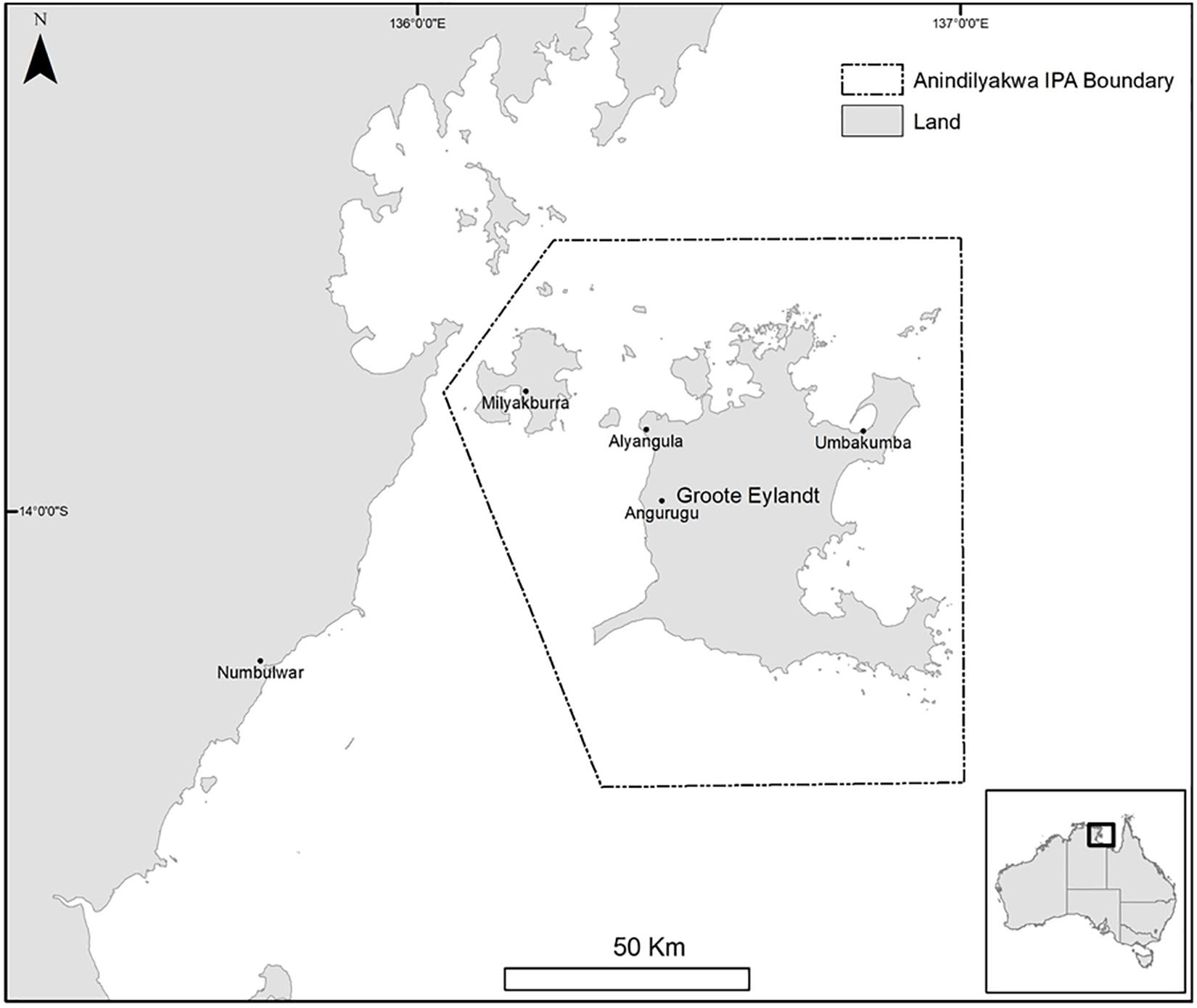
Figure 1. Anindilyakwa Indigenous Protected Area, Groote Eylandt Archipelago, Northern Territory, Australia.
The Anindilyakwa people have inhabited the archipelago for approximately 6000 years and have deep cultural ties to their Sea Country. Not only relied upon for the provision of resources, the waters surrounding the archipelago are also rich in cultural significance and covered in a network of songlines which provide spiritual links between islands and are the basis for social links between Anindilyakwa people and their neighbors on the mainland (Anindilyakwa Land Council, 2012).
The external threat of seabed mining in the waters surrounding the Groote Eylandt Archipelago exposed a gap in both the documentation of traditional knowledge and the scientific understanding of the marine environment. In order to defend the protection of their Sea Country and to better inform management decisions, the Anindilyakwa Land Council (ALC) engaged the Australian Institute of Marine Science (AIMS) in 2016 to undertake an extensive scientific marine mapping project (‘Mapping Makarda’) in order to document benthic habitats and fish biodiversity and distributions. A standard scientific approach to modeling benthic and fish communities was planned using multi-beam hydro-acoustic habitat modeling for deeper waters and satellite imagery to model shallower habitats (e.g., Colquhoun et al., 2007), alongside deployment of baited remote underwater video systems (BRUVS) to assess fish diversity (Whitmarsh et al., 2017). The extremely high turbidity in the near-shore region coupled with strong currents and unreliable bathymetric charts posed a challenge for these standard methods, particularly in the near-shore waters. In addition, the research area of interest was substantial and could not be covered in full, or at a satisfactory resolution, by these standard techniques with the resources available. Given the Anindilyakwa people’s rich bio-cultural knowledge of their Sea Country and the challenges facing the WS approach, the opportunity presented itself to develop a two-way PM research project that achieved the respectful and culturally appropriate mapping of the TEK of marine habitats while at the same time helping to inform and enrich standard WS methods.
In this paper, we describe the participatory mapping component of the Mapping Makarda collaboration between the ALC and AIMS. We share lessons to inform the PM methodology and the broader implications of using PM as a tool to facilitate equitable, culturally appropriate and scientifically robust two-way knowledge sharing. We begin describing the theoretical fundamentals alongside the specific methods used in this PM approach by outlining six key steps required to successfully achieve a collaborative PM project. We provide an overview of the project outcomes and results with a demonstration of the value of TEK as an illustration of cultural knowledge and as a scientific data source. Finally, we discuss important considerations regarding the reciprocal practice of documenting spatial TEK in Indigenous communities that emerged during this process, and the utility of this method to inform management decisions.
Materials and Methods
The Mapping Makarda project was the first time AIMS had collaborated with an Indigenous organization on this scale and similarly, it was the first time the ALC had commissioned such a large scientific project over their Sea Country. As such, there was a significant amount of learning from both parties as the project unfolded to facilitate legitimate scientific methodologies that also followed appropriate cultural protocols. The PM component followed similar methods to those described by Corbett (2009), with the broader process for collaborative saltwater knowledge sharing taking a similar approach to that outlined by Austin et al. (2017). Incorporating established PM best-practice methodology into an Indigenous Australian collaborative context, reflecting the local community dynamics within the Groote Eylandt archipelago, resulted in the identification of a six-step process that was refined throughout the project and explored in detail below (Figure 2).
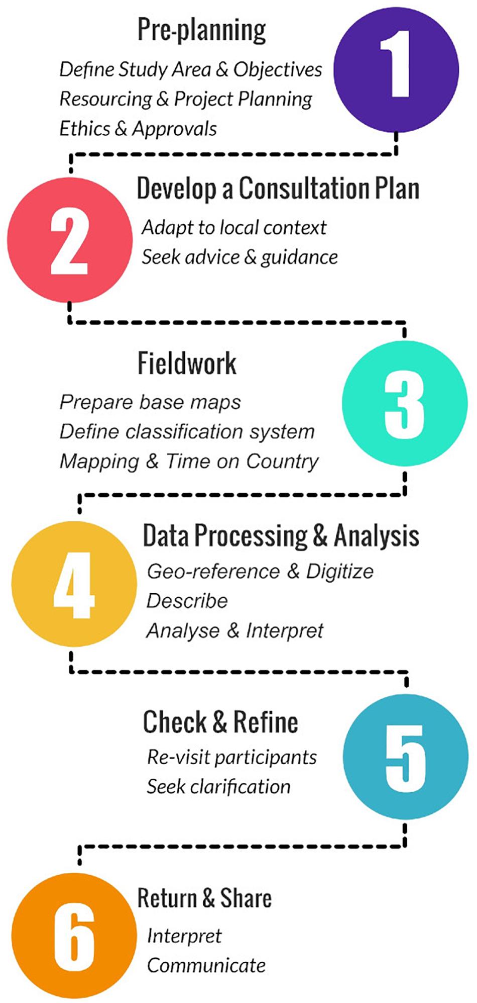
Figure 2. Flow chart depicting six step process for collaborative Sea Country mapping projects.
Pre-planning
Pre-planning is fundamentally about relationship-building and making sure expectations can be met. Before any project can begin, face-to-face meetings and visits to Country are critical in order to build rapport and trust.
Define Study Area and Objectives
It is important to clearly define the knowledge to be mapped in partnership with knowledge holders and to establish protocols over storage, use and dissemination of this knowledge. In these early stages, clarification of any cultural or other sensitivities which may influence how data is handled, or what data can be captured, is essential. Ensuring free, prior and informed consent is a fundamental obligation for any research documenting TEK, and it is at this stage that the Intellectual Property rights of knowledge holders are agreed upon and treated appropriately in any project funding and ethics agreements.
The study area and knowledge to be mapped by the broader Mapping Makarda project were jointly defined by the Anindilyakwa Land Council and AIMS, to cover the ALC’s priority areas of interest within IPA waters. The objectives and intended outputs were discussed to ensure the project aligned with the needs of both the ALC and AIMS. The agreed scope of the participatory mapping project was to identify the types and locations of different marine habitats across the entire IPA, and to collect community knowledge on key species that may be of particular conservation significance to both traditional owners and management agencies.
Resourcing and Project Planning
Once the study area and objectives are agreed upon, detailed project planning needs to ensure there are sufficient resources available and that the project can realistically meet all party’s needs and expectations. Specific considerations for resourcing should include adequate budget to pay for participants travel and time, expectation that a minimum of four extended visits to the community are required to allow for sufficient pre-planning, time to consult with all the appropriate knowledge custodians, meet the need for a contingency trip, and at least one trip to communicate results back to the community. Project timeframes should allow appropriate participation of knowledge holders in the planning phase and provide enough time to ensure free, prior and informed consent.
If there is doubt, or a misalignment of objectives between any project partners (in this case ALC, AIMS and TOs), the project should be discontinued or revised before it goes ahead. Seeking feedback at this stage from prospective participants on their interest in the project, its intended outcomes, whether they are willing to participate/contribute their Intellectual Property (IP), and on what they expect in return for this participation (for example, remuneration and/or project impacts) will facilitate a smoother collaborative project.
When the Mapping Makarda project was initially planned, the participatory mapping component was originally confined to working with the ALC Land and Sea Rangers. However, following the initial workshop with the Rangers, and the separate consultations with TOs, it became clear that extending the PM exercise to include the wider Anindilyakwa community would provide a richer data source and greater TO involvement and ownership over the project. This expansion was regarded as important for achieving the goals of the collaboration, which is why it was resourced internally by AIMS and Charles Darwin University. As the project unfolded, additional research priorities emerged that were able to be accommodated beyond the original scope; this scenario was a reminder to remain adaptive within cross-cultural collaborations.
Ethics and Approvals
Genuine cross-cultural research requires the research proposal to be developed with potential participants, knowledge holders and local organizations. TEK remains the intellectual property of those who contribute it. It is critical that an agreement is made as to how this property will be handled, in what settings it may be reproduced or used, and how it is best communicated to maintain its integrity. Researchers should ensure that the proposed research aligns with the Guidelines for Ethical Research in Australian Indigenous Studies (AIATSES, 2012). Only then should research proposals be submitted to all appropriate bodies; generally, the local land council or other appropriate Indigenous organizations, and the involved academic institution. Finally, researchers need to apply for and receive ethics approvals from relevant Indigenous organizations and research institutions prior to any further work.
At Groote Eylandt, the PM project proposal was developed between the researchers and the ALC Land and Sea Rangers. Standard sitting fees were agreed upon for all participants and administered through the ALC. IP remains with the TOs and any future public use of this information requires approval from the ALC and/or TOs. Approval was granted from the ALC before the Human Ethics approval was granted from the University of Western Australia (UWA Reference RA/4/1/8771), and data collection did not begin until all approvals were granted. Every participant was provided with a detailed explanation of the project scope and intended outcomes, how their knowledge would be used, and made aware that they had the right to withdraw their information at any time. This information was documented in a participant information form and was explained verbally in plain English during each consultation. Wherever possible, a Ranger attended the initial consultation to explain the project in the Anindilyakwa language, and how the outputs would be used by the ALC to improve management and pursue legal protections for Sea Country. Once participants and researchers were satisfied with their understanding of the project they were asked to sign a participant consent form.
Develop a Consultation Plan
Australian Indigenous knowledge custodianship is fundamentally place-based, and authority over knowledge is organized along kinship or familial lines. In many northern Australian regions, territories are delineated by sacred places, song-lines and ancestral narratives (Davis, 2008). Land and knowledge ownership is a function of an individuals’ relationship to these cultural resources. This means that highly targeted sampling is required as specific groups of people have the authority to speak for a specific area of Country. The particular ways in which knowledge and authority are distributed varies regionally, thus it is important that researchers sufficiently grasp the local context and select participants based on advice from the appropriate Indigenous knowledge authorities.
At Groote Eylandt, a participatory mapping exercise was initially conducted with the ALC Land and Sea Rangers. The Rangers came from a range of clan groups from around the island, and so had cultural authorization to speak about most areas of the Sea Country within the Anindilyakwa IPA. Subsequently, based on advice from the Anindilyakwa Land Council and ALC Land and Sea Rangers, the family groups and key senior knowledge holders with custodianship over areas of Sea Country within the IPA were determined to provide the basic framework to build the fieldwork around. Using a standard snowball referral strategy (Faugier and Sargeant, 1997), these initial contacts were then asked for referrals to other community members who had appropriate knowledge and permissions to speak for Sea Country (Figure 3). As a general rule on Groote Eylandt, the senior cultural authorities were approached first and, once their endorsement had been received, consultations were then broadened to other community members, who were frequent users of particular marine environments. In some cases, individuals drew on multiple authorities of diminishing seniority, to map multiple areas. In such cases, participants would first make clear their connection to an area and identify more senior knowledge holders where appropriate. An attempt was made to cover a broad spectrum of knowledge holders with diversity across age, gender, family group and personal experience. Participants were remunerated for their time at a rate agreed upon with the ALC and commensurate with their level of seniority and knowledge.
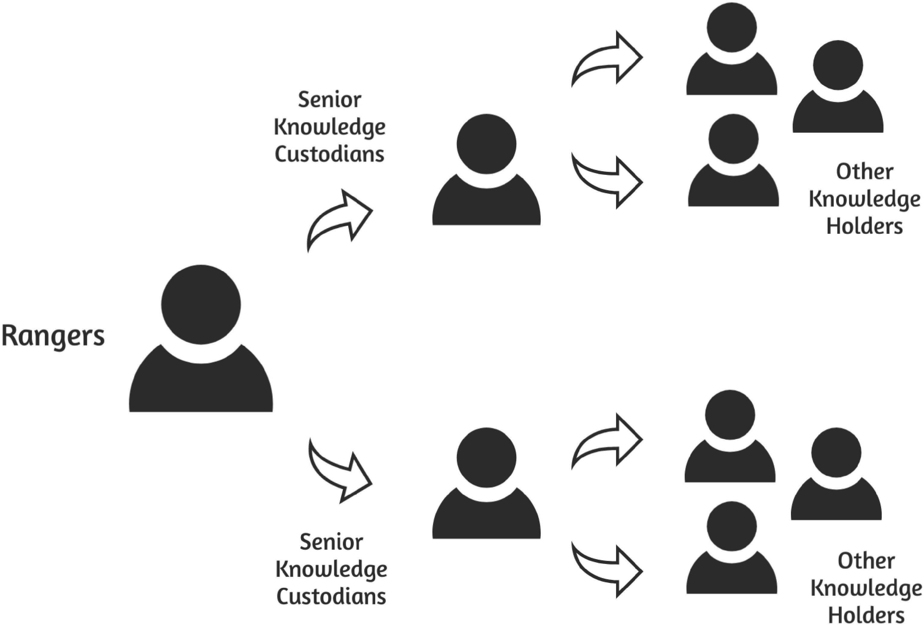
Figure 3. Consultation strategy for participatory mapping of the marine environment in the Groote Eylandt Archipelago.
Fieldwork
Prepare Base Maps
The base map used for participatory mapping activities can significantly alter the results of the mapping exercise. Variables such as scale, map style (i.e., topographic vs. satellite), and medium (i.e., digital vs. paper) need to be carefully considered dependent on the type and resolution of data hoping to be captured, the profile of the participants and the setting for the consultations. In supporting Indigenous Australians to articulate and document their TEK, it is important to acquire an understanding of the local relationships to marine areas and the basis for authority to share knowledge and create maps which are going to be intuitive to, and appropriate for, the participants.
A number of different base maps were trialed at Groote Eylandt and the most effective method found was to use paper maps with high resolution topographic information for the land cover to assist participants in orienting themselves on the map. The base map also included a semi-transparent layer from a nautical chart to help guide participants toward known marine features such as seamounts and rocky islets (noting that these charts had a degree of inaccuracy). A limitation of this approach was that topographic maps use English rather than local names for geographic features. To address this, a map of local names to refer to when undertaking consultations was also used. Satellite images were useful to help with map orientation, however, were less effective for the actual mapping exercise. The paper maps meant they were easily transportable to visit individuals at their homes and on their Country and did not create a technological barrier to use. This format also allowed multiple participants to engage with the same map at the same time, important given the way authority over knowledge of Country is distributed under Anindilyakwa cultural protocols. Thus, our tool kit included at least three maps: a local place name map, a satellite image and the large topographic/marine chart for the collection of data.
The archipelago covers a large area and great consideration was put into the appropriate size and scale of the base maps. Dividing the study area to roughly align with Indigenous land ownership boundaries at a scale of 1:60,000 provided a reasonable resolution for the broad scale habitat information expected while still remaining practical in the field when mapping often occurred on verandas or on the back of a boat.
Define a Classification System
The identification and naming of species in local language can be very challenging. Scientists often try to fit TEK classifications into a Linnaeus western system, which is likely to result in misunderstandings and erode the depth of knowledge TEK provides (Wehi et al., 2009). Habitats in the marine environment from a TEK perspective could be differentiated on the basis of different ecological processes to those prioritized by scientists, on the basis of who goes there or what resources they are good for, and names will often differ between language, community or dialect. As such, a habitat category in Anindilyakwa (or other Indigenous language) terms may include cohorts of animals and benthic species and thus differ from any habitat with an English language equivalent. Yet, in order for TEK to be successfully included within western management and policy decisions it is necessary for TEK classifications to be translated in a manner that can be understood within a western context. It is therefore extremely important to get this step right.
The classification discussion began with the ALC Rangers who spent considerable time discussing different ‘areas’ in Sea Country, talking about ‘what’s on the bottom,’ using visual aids and language dictionaries to identify a classification system in the Anindilyakwa language that was meaningful to participants. Subsequently, English language descriptions were ascribed to each of the Anindilyakwa definitions. Once the classification system was defined, a legend was developed by assigning a specific color or symbol for delineation on the map.
The habitat classification system continued to be refined with every consultation, checking the initial system developed with the Rangers with all other participants. Linguists at the local language center were also consulted to cross-reference the definitions and ensure the words were spelled correctly. During the on-water fieldwork, researchers’ understanding of the Anindilyakwa classification system was checked with the Rangers through in situ observations. The final habitat classifications were compared with the WS CATAMI system (Althaus et al., 2013) to determine where similarities and differences between the two systems exist.
Mapping
The behavior and attitudes of the mapping facilitator will have a significant impact on the outputs. Asking carefully constructed non-leading questions to stimulate the mapping exercise is important. More importantly, stepping back to allow people to think, remember and discuss among themselves is crucial. Participants will come to a natural pause when they feel they have completed their map, at this stage the facilitators should step in to verify their understanding of all the features.
Small groups of no more than four to five people were optimal in the context of the work undertaken here, and two facilitators per group provided a better outcome. This allowed people to bounce ideas off each other without the group becoming unwieldly or dominated by particular individuals, and for multiple conversations to occur simultaneously amongst participants with a facilitator available to answer questions. It is likely that having a male and female (rather than two female) researchers would have helped navigate gender sensitivities (Bainbridge et al., 2013).
During the mapping exercises on Groote Eylandt, we actively encouraged participants to only document areas they were confident they could identify accurately and with cultural authority. Participants used fine-tipped colored pens to mark the known habitat distributions on the base maps. The mapping was carefully facilitated to ensure legends were adhered to and any information that may have been slightly ambiguous was interrogated further with notes added to the map if necessary. At the discretion of participants, additional information including species movement and distribution information, currents and oceanographic trends, seasonal variation, cultural information and ecological processes were also either drawn, annotated or marked with stickers on the base maps. When mapping a very large area it is easy for the scale of the information mapped to be misinterpreted. Discussion of scale during the mapping exercise is useful, for example during this study, when participants were mapping near-shore bands of mawurrira (seagrass), researchers asked for clarity regarding how wide that band was with reference to landmark points visible during the consultation, e.g., “Is it as wide as the distance to that tree over there?” Further checking of scale considerations can also be facilitated with time on Country.
Time on Country
Much knowledge about Country is gained through the experience of spending time on it. As a research step, allowing for visits to Country is important for developing cross-cultural ecological understandings, as it gives participants an opportunity to explain what they are trying to conflate onto a map. The accuracy of the mapped data relies on the researcher’s ability to understand what information is being communicated, and interpret this correctly. It provides an opportunity for discussions about what we can see and the significance of the different areas both ecologically and culturally. Some Elders struggle to get out onto Country regularly due to resource or health constraints, so integrating Country visits into the research methodology recognizes and supports their cultural obligations while also providing a platform for more detailed knowledge sharing. Time on Country also allows participants to have a fresh memory of the tangible places they are trying to represent through the abstract format of a two dimensional map. This can support the recollection of more details about an area than triggered by an office or town-based consultation setting and allows for checking of spatial data.
At Groote Eylandt, a limited number of field visits meant few opportunities to take informants out on Country. Researchers were able to undertake in situ observations of shallow water habitats with the ALC Indigenous Rangers over a period of 4 days aboard their vessel using a bathyscope (Lamand and Beisel, 2014). The bathyscope observations provided the data required to ground truth the subtidal habitats demarcated on the TEK map while also providing researchers with an opportunity to visually identify and discuss Anindilyakwa classifications with the Rangers. The bathyscope observation points were determined using a spatially balanced survey design known as Generalized Random Tessellation Stratified sampling (GRTS) (Brown et al., 2015), which was generated using the R package spsurvey (Kincaid and Olsen, 2011). The bathyscope observations were recorded using percent cover of benthic habitats following the CATAMI classification system (Althaus et al., 2013). This method of survey design attempts to ensure coverage of all the different habitat types, however, the high turbidity at Groote Eylandt meant observations were restricted to <5 m in depth and, due to the large size of the study area, sample sites were restricted to areas that were accessible to the ranger vessels within a single day. These limitations meant some TEK habitat classifications were not sufficiently sampled to enable statistical analysis.
Data Processing and Analysis
The interpretation of the data derived from qualitative mapping techniques has a direct influence on the results. In transformation of the data from paper to digital format, care needs to be taken to maintain the highest level of spatial accuracy possible. It is then up to the researcher to objectively describe, analyze and interpret the data in a manner that accurately represents the information conveyed by participants (Suchan and Brewer, 2000). We recommend that transformation and coding of the data is carried out as early as practicable after the mapping exercise.
Immediately following each round of fieldwork, the completed maps were scanned in high resolution and georeferenced in ArcMap 10.3 using the nautical chart as the reference layer, a minimum of 4 points per image were used with a minimum accuracy of 10 m2. The georeferenced maps were then digitized manually to create polygon and point shape files delineating habitat types, species occurrences, and other information. Knowledge shared that could not be communicated spatially was added to the attributes table as ‘notes.’
The digitized TEK maps were combined within Arc GIS 10.3 to assess similarities and differences of the spatial information shared by the participants, and the most frequently occurring habitat class in any given area was identified. The final TEK habitat map was an amalgamation of the most frequently occurring classifications. To visualize the distribution of TEK data density, a heat map was generated in ArcGIS 10.3 through the union of the individual TEK maps followed by a count of individual data points where the overlapping layers intersected. Standard scientific habitat classification methods were used in the field (Supplementary Material 1) and a k-means cluster analysis (Hartigan and Wong, 1979) using the R statistical software package generated habitat classes from the in situ observations. K-means was run with 20 random starts and a maximum of 1000 iterations for convergence. An elbow plot (Supplementary Material 2) was used to select six WS habitat clusters.
The habitat classes derived from the time on Country were cross-referenced with the Anindilyakwa habitat classes for comparison, and both data sets were fit into the CATAMI classification system (Althaus et al., 2013). Validation of the TEK map using the bathyscope observations was carried out in R through the generation of a confusion matrix (Lewis and Brown, 2001), which compares predicted (TEK) with actual (WS) outcomes. A pairwise comparison of the two datasets was carried out using the Kappa statistic, which determines the similarity of the datasets after accounting for resemblance due to chance (Monserud and Leemans, 1992). A geographical representation of agreement between the TEK map and the validation points was generated in ArcMap 10.3.
Check and Refine
Throughout every step of the project, maps and other outputs need to be checked with the participants to eliminate misunderstandings, ensure the knowledge initially shared is still permitted to be shared within the intended format, and to recognize the co-ownership of the outputs. It is important that researchers are present to discuss results and to check that the outputs are aligned with the needs and uses of the community as identified in the planning stages, that they also remain responsive to any development that occurred over the course of the project.
We took every opportunity during each of the field trips to revisit senior knowledge holders to check the previous mapping results and habitat classifications and refined the maps in response to their requirements. For example, one senior TO withdrew permission late in the project for inclusion of an area dense with sacred sites. It was not logistically possible to revisit all TOs who engaged in the PM process, therefore significant time was spent with the ALC Rangers checking and refining the results in order to equip them with sufficient understanding to feedback to the broader community. We also continuously refined our understanding of the Anindilyakwa habitat classifications to ensure our WS understanding was an accurate representation of the TEK descriptions.
Return and Share
Returning to the community with the final outputs to share and interpret the results is critical to ensure a genuine cross-cultural outcome and continued positive relationships within the community. Researchers returned to Groote Eylandt on multiple occasions to work in collaboration with the ALC and Rangers to develop a series of posters and videos in both the Anindilyakwa language and English to communicate the results of the project. A detailed workshop was then held to provide feedback of research findings to Rangers and the Land Council and a storybook was distributed alongside a printed copy of the final TEK map to the families of all project participants.
Limitations
Limited field trips and cultural obligations of TOs while we were on Country meant we were not able to consult with all the senior knowledge holders within each clan group; therefore data represented here is not an exhaustive take on TOs knowledge. The WS validation samples were restricted to very shallow areas within close proximity to boat ramps thus were only achieved across a small section in the northern region of the study area (Figure 7) and habitat types.
Results
A total of 53 members of the Anindilyakwa community contributed to the participatory mapping exercise which generated 22 individual maps. The most detailed and frequently documented areas were generally those found closer to shore and in proximity to the main communities (Figure 4). TEK relating to Sea Country habitats covered a combined area of ∼1,800 km2 (25% of the IPA waters) with 11 classes described in the Anindilyakwa language (Figure 5). Of these, eight Anindilyakwa habitat classes were sub-tidal. When matched with CATAMI equivalent habitat classes, two different sand descriptions (yiningilya and yilyirriya) were collapsed into coarse sand. Notably, one of the most prevalent Anindilyakwa classes, amindurrkalarruwa (patch reef), directly translated as “a little bit”, did not fit into any existing WS habitat categories (Figure 6). Simplifying the classification system to the substrate level resulted in two CATAMI categories: consolidated (hard) and unconsolidated (soft). The addition of a mixed category allowed for the inclusion of amindurrkalarruwa within the comparative analysis (Figure 6).
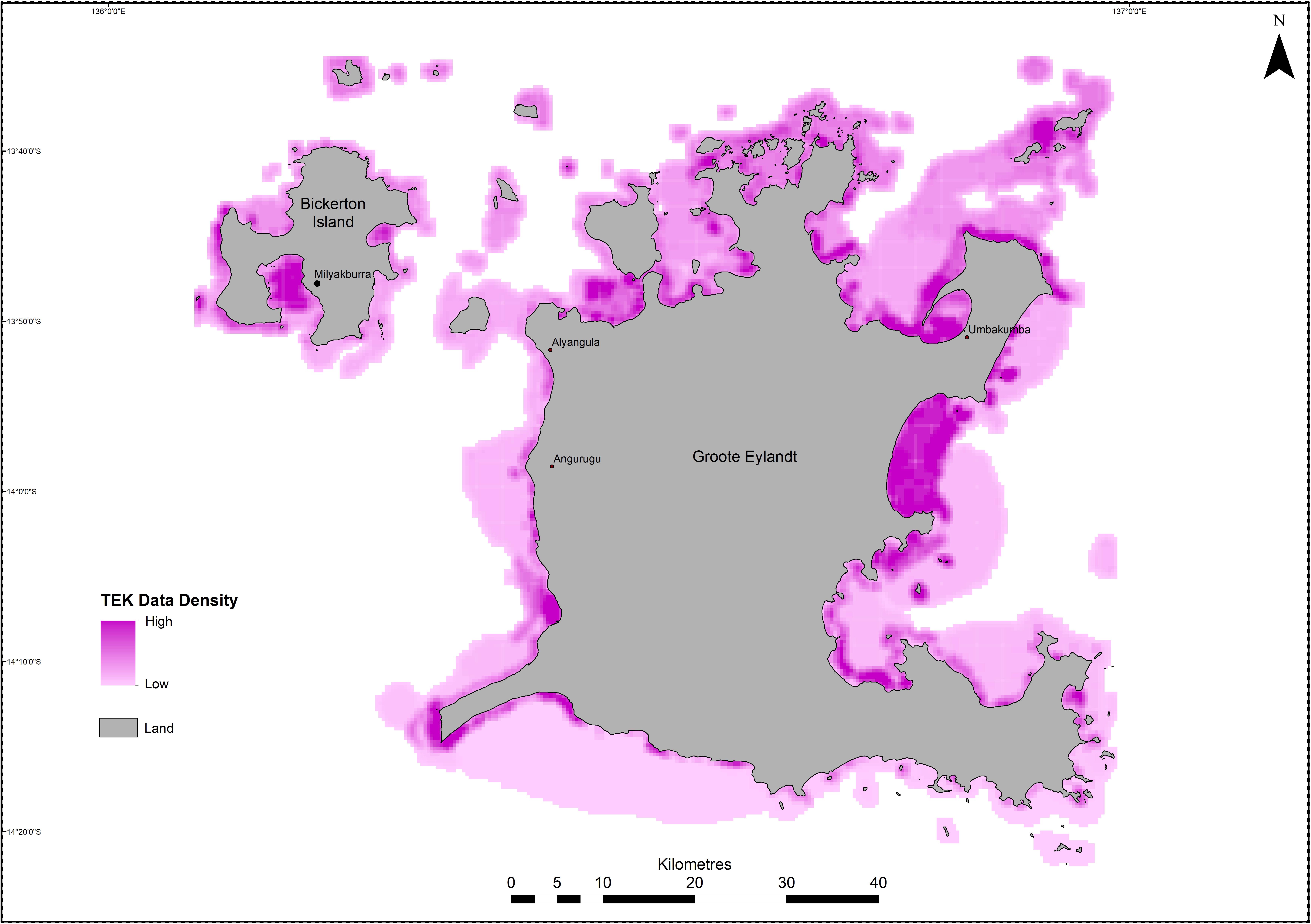
Figure 4. Data density of Sea Country TEK collected through participatory mapping in the Groote Eylandt Indigenous Protected Area.
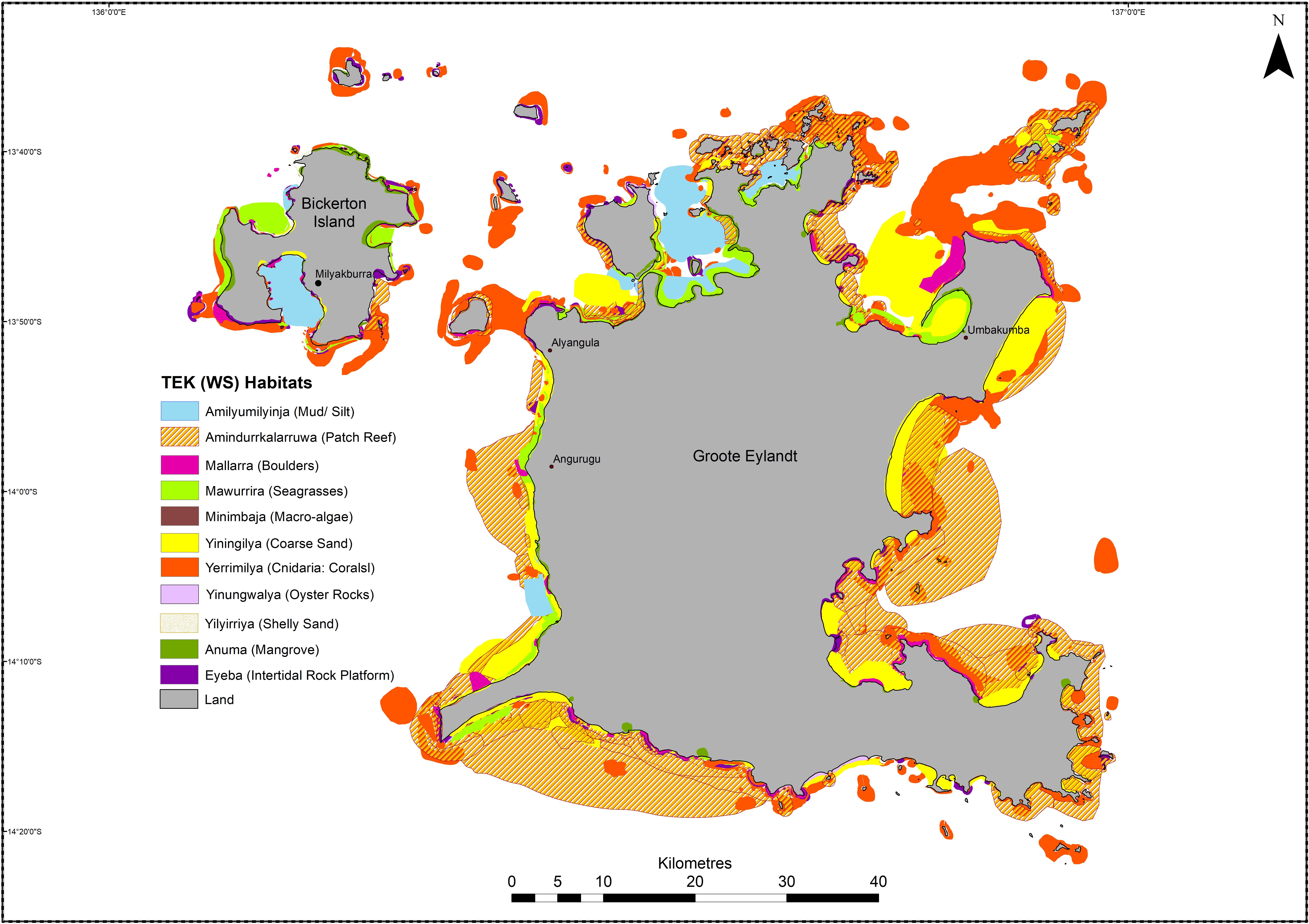
Figure 5. Marine benthic habitat map of the Groote Eylandt Archipelago derived from Traditional Ecological Knowledge.
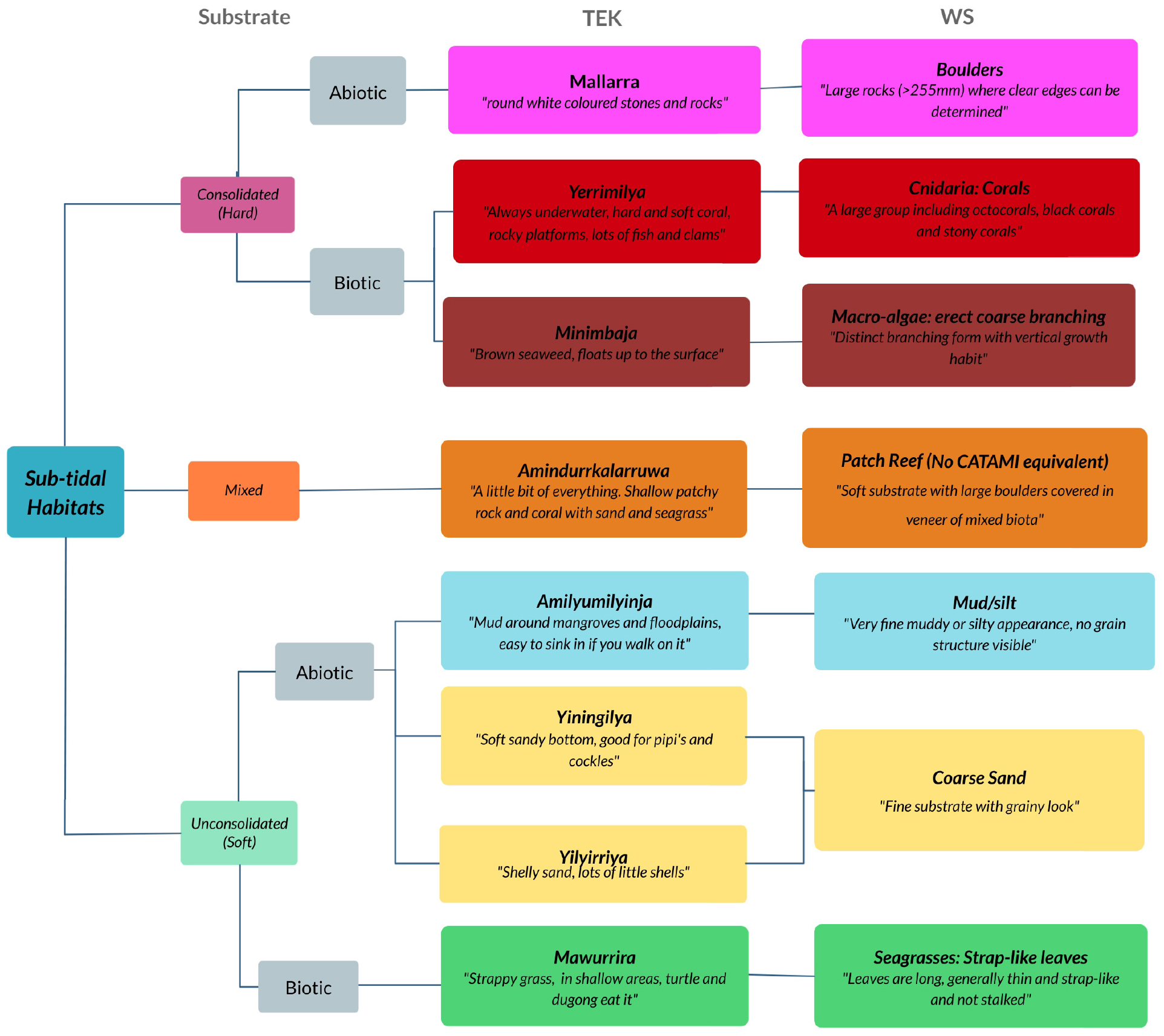
Figure 6. Comparative benthic habitat classifications of Anindilyakwa traditional ecological knowledge and standard western science CATAMI categories.
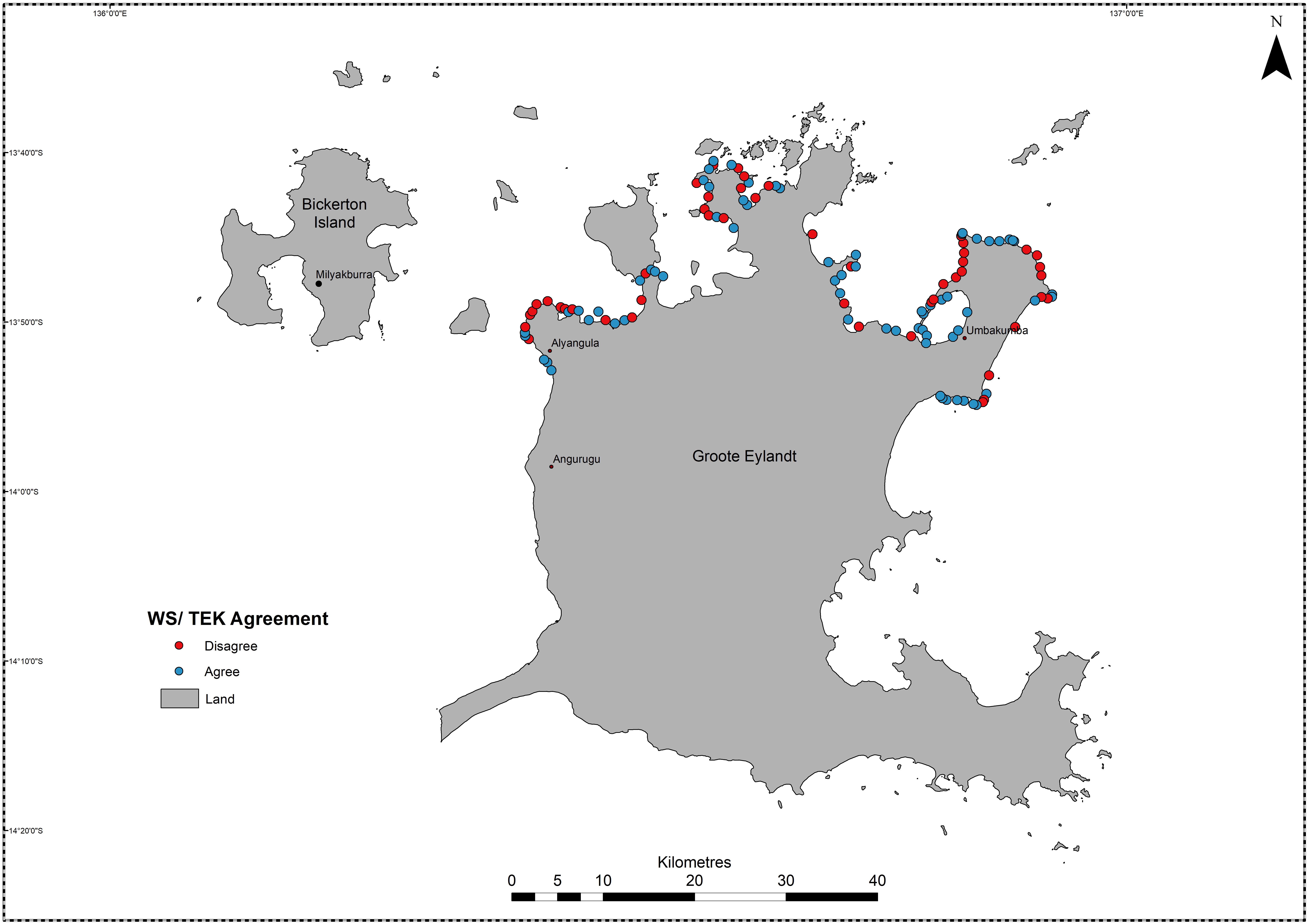
Figure 7. Geographic spread of agreement and disagreement between Anindilyakwa benthic habitat types and western science observations.
A total of 137 in situ observations using a bathyscope were completed, and seven WS habitat classifications were observed (Figure 6). There was only one observation of the boulders class, and as such, this was not picked up in the k-means clusters and thus not included in the statistical analysis. Four habitat classes were identified as suitable for comparison between the TEK maps and WS observations. Overall, there was a higher level of agreement than disagreement between the two datasets with a kappa value of 0.46 (where -1 is completely dissimilar and +1 is exactly the same) and a balanced accuracy of 70–94%. The highest level of agreement was found in the yerrimilya (cnidaria: corals) category with a 100% match, the lowest level of agreement was within the most variable habitat type amindurrkalarruwa (patch reef) (Table 1). When plotted geographically, there was a higher level of agreement clustered around headlands and in closer proximity to the Umbakumba community (Figure 7).
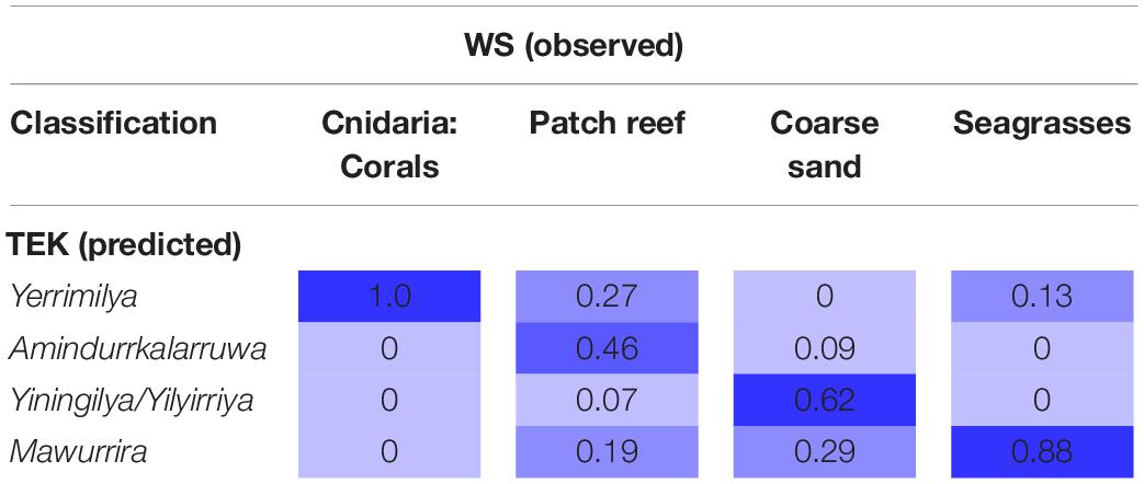
Table 1. Four habitat class confusion matrix (numbers indicate the proportion of WS observations that were the same as TEK classifications, darker colors show higher level of agreement).
Discussion
The importance of two-way knowledge sharing to support ecosystem management and conservation has been increasingly recognized (Barber et al., 2014; Stori et al., 2019). Participatory mapping is a widely used methodology for collation of TEK, for informing natural resource management (Mellado et al., 2014), and as a valuable tool for the collation of inherently place-based Indigenous knowledge (Robinson et al., 2016). This paper presents a replicable methodology suitable for documenting the TEK of the marine environment. It demonstrates a refined, step-wise process to ensure accuracy in the documenting of TEK, which respects the integrity of Indigenous knowledge systems.
Through the Anindilyakwa case study we provide insights regarding the practical application of the participatory mapping methodology in an Indigenous Australian Sea Country context, and demonstrate a small subset of the extensive TEK held by the Anindilyakwa people. The quantitative accuracy assessment continues to demonstrate the value of TEK as a valid source of scientific information when looked at through a WS lens.
Participatory Mapping as a Tool for ‘Right-Way’ Research
Historically, Indigenous people across the world have predominantly been the subject of unidirectional research (Johnson et al., 2007). However, global treaties such as the 1992 Convention on Biological Diversity and UNESCO’s 1999 Declaration on Science and the Use of Scientific Knowledge are attempting to redress the balance (Ens et al., 2015). Recent outputs from Australia such as the Reef 2050 report (Jarvis et al., 2019) and the Kimberley Indigenous Saltwater Science Project (Austin et al., 2018) have made it clear that scientists have an obligation to follow appropriate cultural protocols, work in partnership with TOs and underpin their research of the natural world with TEK. The PM methodology outlined here is one tool available for Sea Country researchers to utilize in order to effectively facilitate collaborative two-way research projects. We found the most important steps to be the pre-planning and development of a comprehensive consultation plan in order to respect the traditional governance of knowledge custodianship by ensuring we consulted with all the appropriate knowledge holders (Austin et al., 2018). Representativeness is different from TO and WS standpoints. This can go against standard WS practices of sample design whereby the optimal number of samples is the minimum required to get a representative selection of the study area (Chiarucci et al., 2008). Local context is important and, provided adjustments are made to reflect different cultural governance systems, this methodology can be replicated across other Indigenous communities both within Australia and internationally. In addition to benthic habitats, PM can capture a much wider set of knowledge such as species movement and distribution information, currents and oceanographic trends, cultural information and ecological processes. It is important to note, however, that this methodology may not be appropriate in other cultural contexts, for example where TOs have been displaced from Country.
Placing TEK Into a WS Construct
Participatory Mapping is an effective method for documenting aspects of place based cultural knowledge and values (Robinson et al., 2016). Mapping alone can result in the loss of much of the richness associated within TEK systems, as maps run the risk of oversimplifying extremely complex cultural understandings (Levine and Feinholz, 2015). For example, TEK provides extensive temporal understandings of ecosystems, particularly with regards to seasonal variations (Prober et al., 2011), moons and tides, and cultural insights. With more time and fine-tuned mapping questions, some of this complex knowledge could be mapped, for example ephemeral seagrass meadows or single species distributions could be mapped corresponding to the different Indigenous seasons. Even with more detailed mapping objectives, much of the intrinsic non-spatial Indigenous knowledge will still be omitted. This study attempted to include some of the non-spatial information through the addition of detailed notes within the GIS files produced, and accompanying storybooks shared with the community. However, accurately mapping the full range and complexity of TEK remains a challenge. Within the TEK system, as with WS-based ecology, no system is static and in an ideal world, maps would be regularly updated. Maps such as these are tools that are most powerful when they are used by Indigenous people themselves. As members of the intellectual community that generated the maps, they understand the context of the information conveyed. Knowledge holders can use this mapped information to plan and implement bicultural conservation management as part of their ongoing cultural and intellectual traditions as contemporary Indigenous Australian communities. The maps and other products generated by the Mapping Makarda project remain the property of an Indigenous organization which represents the TO participants. The outputs have already been used by the Rangers to inform a marine monitoring program, and it is hoped that they will continue to be utilized by current and future generations of Anindilyakwa people to look after their Sea Country in ways that are meaningful to them.
Attempting to fit the Anindilyakwa habitat classifications into the WS CATAMI classification system echoed the difficulties commonly encountered by ethno-scientists globally (Berkes, 2017). With fundamentally different worldviews, the way WS observes and describes environments is strikingly different from that of a TEK worldview. Often WS describes patterns whereas TEK tends to consider more complex processes or purposes within their terminology. For example the TEK classification of a Peruvian rainforest was far more detailed than the WS equivalent (Halme and Bodmer, 2007); in Tanzania, Maasai pastoralists were able to describe discrete environmental change that may have been undetected by WS (Mapinduzi et al., 2003); and in Southern India, the TEK classification system for plants was found to be more robust than the WS equivalent (Newmaster et al., 2007). However, in other international studies, the TEK mapped was lower in complexity than the WS approach (Teixeira et al., 2013). In this study, the most complex habitat class (Amindurrkalarruwa) did not fit into the CATAMI system and also was the most variable class when described by participants. Directly translated as “a little bit,” this was an ecological system characterized by its variability but known to be excellent for fishing and distinctive in its composition from other areas of Sea Country. The challenges of classifying benthic habitats in a uniform manner are not limited to data from different knowledge systems. Even within WS, habitat categories may not align over temporal datasets as technology improves and new levels of detail are discovered. For example, Ningaloo reef marine park planning utilized broad scale habitat maps derived from aerial photographs and expert knowledge (Bancroft, 2003). A decade later, highly detailed maps were generated using hyperspectral imagery (Kobryn et al., 2013). It is evident that, in some cases, TEK can provide a higher degree of complexity of knowledge but risks losing that same complexity if shoehorned into a WS classification system, and in other scenarios the opposite is true. Here, we found that attempting to merge the two classification systems led to a loss of important detail. Yet, for TEK to be understood by WS there needs to be some attempt to translate the information. We suggest, through displaying the two systems side by side, rather than combining them, TEK and WS can be treated as equal sources of different information and provide a more complete ecosystem story.
TEK as a Scientific Source of Information
Resource managers and scientists often question the scientific value of TEK (Levine and Feinholz, 2015). Here we have demonstrated that the PM of the TEK of the Anindilyakwa people, with regards to benthic habitats, reveals results consistent with other WS habitat mapping and modeling methodologies, and that the ‘accuracy’ of the TEK models are comparable to other scientific studies of benthic habitat mapping in turbid environments using advanced remote sensing methods (Gaida et al., 2019) and predictive modeling of deep water habitats (Hovey et al., 2012). There can be a WS viewpoint that qualitative maps derived from TEK are imprecise. However, there is substantial evidence from similar approaches that the results and spatial accuracy within a WS context from TEK mapping activities are consistent with WS methods (Teixeira et al., 2013; Cox et al., 2014).
Particularly in the context of regions where WS is scarce, the PM of TEK provides the means to obtain the best ecological information available in a format consistent with WS and natural resource management decision-makers. These results reflect similar findings from mapping the TEK of fishers in Brazil (Teixeira et al., 2013) and the Solomon Islands (Aswani and Lauer, 2006). Despite positive results from many similar studies, the requirement from the WS community for validation of TEK continues to exist, which could be considered disrespectful to the worth of TEK in its own right. However Gratani et al. (2011) illustrate that validation was found to be empowering for traditional knowledge holders. This sentiment was echoed by this project where we found that TOs were proud to have their knowledge put on an equal footing with scientific knowledge (something not many had encountered before), and reflected the respect they themselves held for both types of knowledge.
As with any scientific method, PM of TEK has limitations. Turbidity was an issue for traditional knowledge holders, just as it is for WS practitioners. One participant explained that when they cannot see the bottom they use a stick to distinguish areas that are hard or soft, with hard substrate preferable for fishing. As a result of colonization and the dispossession of lands, many elders do not have the ability to access their Sea Country regularly, and while this project encountered impressive recall, the detail and accuracy of TEK may be eroded over time if access remains a challenge. Mapping TEK will always be limited by a tradeoff between scale and accuracy. For example, there was an area of high disagreement between the TEK and WS validation in Umbakumba Bay where the TEK classification was mawurrira (seagrass) yet the WS classification was sand. Time on Country revealed there is a narrow band of seagrass close to shore which is abutted by a large sandy area. If the study had focused on a fine-scale area this disagreement would likely have been resolved.
Broadly speaking, the accuracy of the TEK map against the WS observations was high, with the lowest degree of agreement tied to the most variable habitat classification. However, the accuracy assessment was limited by the depth and range restrictions of the bathyscope observations. The breadth and accuracy of TEK is commonly higher in the shallow, near-shore environments most frequently visited by knowledge holders (Selgrath et al., 2016). As such, if we had been able to expand the WS observations, beyond the <5 m depth limits, to areas visited less regularly, the overall accuracy may have been lower. In this study, the areas most commonly mapped with TEK were the areas where remote sensing and hydro-acoustic mapping were most difficult. The combination of TEK with WS can therefore paint a more comprehensive picture of the marine environment. For example, in the Solomon Islands, Lauer and Aswani (2008) found the combination of TEK with satellite imagery not only generated enhanced benthic habitat maps, but also allowed the dissemination of important socio-ecological information.
Utility for Marine Management
In recent years in Australia, there has been an increased emphasis on Indigenous land and sea management, and joint management arrangements between Indigenous and non-Indigenous partners (Ross et al., 2009). Through these arrangements, Indigenous Rangers employ two-way knowledge practices for much of their work, using WS to support their cultural practices. Maps of TEK can provide a foundation to this new collaborative management approach through the identification of the bio-cultural systems considered important by the TOs of the Country where management is taking place. For example, Amindurrkalarruwa (patch reef) areas in Groote Eylandt were highlighted by TOs as particularly important areas for customary fishing and therefore might garner additional management interventions in the face of increasing environmental pressures. Importantly, the mapping of TEK can provide the information required to achieve the management of cultural objectives central to joint management plans (Ross et al., 2009).
The TEK maps produced by this study were used to inform the broader sample design for the Mapping Makarda fish diversity survey. In addition, they were also used, in conjunction with identification of culturally important species, to design a monitoring program for the ALC Land and Sea Rangers, with similar methods used for the same program in Bardi Jawi Country in Western Australia (Depczynski et al., 2019). TEK maps of benthic habitats proved to be an empowering and effective method for Indigenous Rangers to have full ownership over the resulting Sea Country monitoring program.
Conclusion
The Indigenous and western knowledge systems are inherently different, and by respecting both, observing them side-by-side, we can create a more powerful understanding of our natural world. Despite TEK being applied to marine and fisheries management in developing and data poor nations for over 50 years (Johannes, 1984), cross-cultural ecological research, particularly within the marine environment, has not yet reached its full potential (Gratani et al., 2011). Like any complex methodology, it requires thought, rigor and practice to get it right. Here we have outlined a robust methodology that enabled a collaborative Sea Country research project driven by the TEK of the Anindilyakwa people. Documenting the TEK of Sea Country using participatory mapping generated outputs that celebrated the rich bio-cultural knowledge of the Anindilyakwa people, while also creating a habitat map suitable for use within a WS framework. Through sharing the lessons learned and methodological considerations outlined, we mean to progress the journey toward a more inclusive, cross-cultural pathway for scientific enquiry.
Data Availability Statement
The datasets created by this study contain the Intellectual Property (IP) of the Anindilyakwa people. To adhere to the ethical guidelines for dealing with the IP of Indigenous Peoples, this data set is not publically available. Permission to access the data set can be sought via the first author, HD at harriet.davies@uwa.edu.au.
Ethics Statement
The studies involving human participants were reviewed and approved by University of Western Australia Human Research Ethics Committee. The participants provided their written informed consent to participate in this study.
Author Contributions
HD and JG designed the research and collected the data. The Anindilyakwa Land and Sea Rangers and Traditional Owners informed the consultation plan, assisted with data collection and provided all the TEK. HD and BR performed the data analysis. HD, JG, RH, BR, and GK wrote the manuscript.
Funding
UWA provided a Scholarship to HD. AIMS funded the project. AIMS and CDU funded the postdoctoral position for JG.
Conflict of Interest
The authors declare that the research was conducted in the absence of any commercial or financial relationships that could be construed as a potential conflict of interest.
Acknowledgments
The Anindilyakwa Land and Sea Rangers generously provided support for this project through providing accommodation, vehicles and Ranger hours and expertise. The authors thank the Anindilyakwa knowledge custodians for generously sharing their time and knowledge and for allowing us to work alongside them on their Country.
Supplementary Material
The Supplementary Material for this article can be found online at: https://www.frontiersin.org/articles/10.3389/fmars.2020.00716/full#supplementary-material
References
AIATSES (2012). Guidelines for Ethical Research in Australian Indigenous Studies. Canberra: AIATSES.
Althaus, F., Hill, N., Edwards, L., and Ferrari, R. (2013). CATAMI Classification Scheme for Scoring Marine Biota and Substrata in Underwater Imagery – A Pictorial Guide to the Collaborative and Annotation Tools for Analysis of Marine Imagery and Video (CATAMI) Classification Scheme. Available at: http://catami.org/classification. (Accessed December 04 2015)
Aswani, S., and Lauer, M. (2006). Benthic mapping using local aerial photo interpretation and resident taxa inventories for designing marine protected areas. Environ. Conserv. 33, 263–273. doi: 10.1017/S0376892906003183
Austin, B., Robinson, C., Lincoln, G., Dobbs, R., Tingle, F., Oades, D., et al. (2018). “Mobilising Indigenous Knowledge for the Collaborative Management of Kimberley Saltwater Country,” Final Report of project 1.5.1 the Kimberley Indigenous Saltwater Science Project (KISSP). Prepared for the Kimberley Marine Research Program, Western Australian Marine Science Institution: Perth
Austin, B., Robinson, C., Lincoln, G., Mathews, D., Oades, D., Wiggan, A., et al. (2017). Guidelines for Collaborative Knowledge Work in Kimberley Saltwater Country. Report to the Kimberley Indigenous Saltwater Science Project (KISSP), Broome: Western Australian Marine Science Institute (WAMSI).
Bainbridge, R., Tsey, K., Brown, C., Mccalman, J., Cadet-James, Y., Margolis, S., et al. (2013). Coming to an ethics of research practice in a remote aboriginal australian community. Contemp. Nurse 46, 18–27. doi: 10.5172/conu.2013.46.1.18
Balbi, S., Selomane, O., Sitas, N., Blanchard, R., and Kotzee, I. (2019). Human dependence on natural resources in rapidly urbanising South African regions. Environ. Res. Lett. 14:044008.
Ban, N. C., Frid, A., Reid, M., Edgar, B., Shaw, D., and Siwallace, P. (2018). Incorporate Indigenous Perspectives for Impactful Research and Effective Management. Nat. Ecol. Evol. 2, 1680–1683. doi: 10.1038/s41559-018-0706-700
Bancroft, K. P. (2003). A standardised classification scheme for the mapping of shallow-water marine habitats in Western Australia. Fremantle, WA: Marine Conservation Branch, Department of Conservation and Land Management, Report MCB-05/2003.
Barber, M. A., Jackson, S. B., Shellberg, J. B., and Sinnamon, V. C. (2014). Working knowledge: characterising collective indigenous, scientific, and local knowledge about the ecology, hydrology and geomorphology of oriners station, cape york peninsula, Australia. Rangeland J. 36, 53–66.
Barber, M., Jackson, S., Dambacher, J., and Finn, M. (2015). The persistence of subsistence: qualitative social-ecological modeling of indigenous aquatic hunting and gathering in tropical Australia. Ecol. Soc. 20:60 doi: 10.5751/ES-07244-200160
Berkes, F., Colding, J., and Folke, C. (2000). Rediscovery of traditional ecological knowledge as adaptive management. Ecol. Appl. 10, 1251–1262. doi: 10.1890/1051-0761(2000)010[1251:roteka]2.0.co;2
Brown, J. A., Robertson, B. L., and McDonald, T. (2015). Spatially balanced sampling: application to environmental surveys. Procedia Environ. Sci. 27, 6–9. doi: 10.1016/j.proenv.2015.07.108
Chiarucci, A., Bacaro, G., Rocchini, D., and Fattorini, L. (2008). Discovering and rediscovering the sample-based rarefaction formula in the ecological literature. Commun. Ecol. 9, 121–123. doi: 10.1556/ComEc.9.2008.1.14
Colquhoun, J., Heyward, A., Rees, M., Twiggs, E., Fitzpatrick, B., Mcallister, F., et al. (2007). Ningaloo Reef Marine Park Benthic Biodiversity Survey. Perth: Western Australian Marine Science Institution.
Corbett, J. (2009). Good Practices in Participatory Mapping: A Review Prepared for the International Fund for Agricultural Development. Rome: IFAD
Cox, C., Morse, W., Anderson, C., and Marzen, L. (2014). Applying public participation geographic information systems to wildlife management. Hum. Dimens. Wildlife 19, 200–214. doi: 10.1080/10871209.2014.871663
Dalleau, M., Andréfouët, S., Wabnitz, C. C., Payri, C., Wantiez, L., Pichon, M., et al. (2010). Use of habitats as surrogates of biodiversity for efficient coral reef conservation planning in Pacific Ocean Islands. Conserv. Biol. 24, 541–552. doi: 10.1111/j.1523-1739.2009.01394.x
Davies, J., Hill, R., Walsh, F. J., Sandford, M., Smyth, D., and Holmes, M. C. (2013). Innovation in management plans for community conserved areas: experiences from australian indigenous protected areas. Ecol. Soc. 18:14 doi: 10.5751/ES-05404-180214
Davis, M. (2008). Indigenous knowledge: beyond protection, towards dialogue. Ausralian J. Indigenous Educ. 37, 25–33. doi: 10.1375/s132601110000034x
Depczynski, M., Cook, K., Davies, H., Evans-Illidge, L., Forester, T., George, K., et al. (2019). Marine monitoring of australia’s indigenous sea country using remote technologies. J. Ocean Technol. 14, 60–75.
Dobbs, R. J., Davies, C. L., Walker, M. L., Pettit, N. E., Pusey, B. J., Close, P. G., et al. (2015). Collaborative research partnerships inform monitoring and management of aquatic ecosystems by indigenous rangers. Rev. Fish Biol. Fisher. 26, 711–725. doi: 10.1007/s11160-015-9401-9402
Drew, J. A. (2005). Use of traditional ecological knowledge in marine conservation. Conserv. Biol. 19, 1286–1293. doi: 10.1111/j.1523-1739.2005.00158.x
Dudgeon, P., Wright, M., Paradies, Y., Garvey, D., and Walker, I. (2010). “The social, cultural and historical context of aboriginal and torres strait islander australians,” in Working Together: Aboriginal and Torres Strait Islander Mental Health and Wellbeing Principles and Practice. eds N. Purdie, P. Dudgeon, and R. Walker (Canberra, A. C. T: Australian Institute of Health and Welfare).
Ens, E. J., Pert, P., Clarke, P. A., Budden, M., Clubb, L., Doran, B., et al. (2015). Indigenous biocultural knowledge in ecosystem science and management: review and insight from Australia. Biol. Conserv. 181, 133–149. doi: 10.1016/j.biocon.2014.11.008
Faugier, J., and Sargeant, M. (1997). Sampling hard to reach populations. J. Adv. Nurs. 26, 790–797. doi: 10.1046/j.1365-2648.1997.00371.x
Gaida, T. C., Snellen, M., van Dijk, A. G. P. T., and Simons, D. G. (2019). Geostatistical modelling of multibeam backscatter for full- coverage seabed sediment maps. Hydrobiologia 845, 55–79. doi: 10.1007/s10750-018-3751-3754
Garnett, S. T., Burgess, N. D., Fa, J. E., Fernández-Llamazares, Á, Molnár, Z., Robinson, C. J., et al. (2018). A spatial overview of the global importance of indigenous lands for conservation. Nat. Sustainab. 1, 369–374. doi: 10.1038/s41893-018-0100-106
Gratani, M., Butler, J. R. A., Royee, F., Valentine, P., and Burrows, D. (2011). Is validation of indigenous ecological knowledge a disrespectful process? a case study of traditional fishing poisons and invasive fish management from the wet tropics, Australia. Ecol. Soc. 16:25.
Halme, K. J., and Bodmer, R. E. (2007). Correspondence between scientific and traditional ecological knowledge: rain forest classification by the non-indigenous ribereños in peruvian amazonia. Biodivers. Conserv. 16, 1785–1801. doi: 10.1007/s10531-006-9071-9074
Hartigan, J. A., and Wong, M. A. (1979). Algorithm AS 136: a K-Means clustering algorithm. Appl. Statist. 28, 100–108. doi: 10.2307/2346830
Horstman, M., and Wightman, G. (2001). Karparti ecology: recognition of aboriginal ecological knowledge and its application to management in north-western Australia. Ecol. Managem. Restorat. 2, 99–109. doi: 10.1046/j.1442-8903.2001.00073.x
Hovey, R. K., Van Niel, K. P., Bellchambers, L. M., and Pember, M. B. (2012). Modelling deep water habitats to develop a spatially explicit, fine scale understanding of the distribution of the western rock lobster, panulirus cygnus. PLoS One 7:e34476. doi: 10.1371/journal.pone.0034476
Jarvis, D., Hill, R., Buissereth, R., Moran, C., Talbot, L. D., Bullio, R., et al. (2019). Monitoring the Indigenous Heritage within the Reef 2050 Integrated Monitoring and Reporting Program: Final Report of the Indigenous Heritage Expert Group: Townsville, TSV: Great Barrier Reef Marine ParkAuthority
Johannes, R. E. (1978). Traditional marine conservation methods in oceania and their demise. Ann. Rev. Ecol. Evol. Systemat. 9, 349–364. doi: 10.1146/annurev.es.09.110178.002025
Johannes, R. E. (1984). Marine conservation in relation to traditional life-styles of tropical Artisanal Fishermen. Environmentalist 4, 30–35. doi: 10.1007/bf01907290
Johnson, J. T., Cant, G., Howitt, R., and Peters, E. (2007). Creating anti-colonial geographies: embracing indigenous peoples. knowledges and rights. Geograph. Res. 45, 117–120. doi: 10.1111/j.1745-5871.2007.00441.x
Jones, K. R., Klein, C. J., Halpern, B. J., Venter, O., Grantham, H., Kuempel, C. D., et al. (2018). The location and protection status of earth’s diminishing marine wilderness. Curr. Biol. 28, 1–7. doi: 10.1016/j.cub.2018.06.010
Kincaid, T. M., and Olsen, A. R. (2011). Sp Survey: Spatial Survey Design and Analysis. R package version 2.2.
Kobryn, H. T., Wouters, K., Beckley, L. E., and Heege, T. (2013). ningaloo reef: shallow marine habitats mapped using a hyperspectral sensor. PLoS One 8:e70105. doi: 10.1371/journal.pone.0070105
Lamand, F., and Beisel, J.-N. (2014). Proposal for a simple hydromorphological habitat survey method for freshwater bivalve (unionidae) inventories. Aquatic Ecol. 48, 237–245. doi: 10.1007/s10452-014-9479-y
Lauer, M., and Aswani, S. (2008). integrating indigenous ecological knowledge and multi-spectral image classification for marine habitat mapping in oceania. Ocean Coast. Manag. 51, 495–504. doi: 10.1016/j.ocecoaman.2008.04.006
Levine, A. S., and Feinholz, C. L. (2015). Participatory GIS to inform coral reef ecosystem management: mapping human coastal and ocean uses in Hawaii. Appl. Geography 59, 60–69. doi: 10.1016/j.apgeog.2014.12.004
Lewis, H. G., and Brown, M. (2001). A generalized confusion matrix for assessing area estimates from remotely sensed data. Int. J. Remote Sens. 22, 3223–3235. doi: 10.1080/01431160152558332
Mapinduzi, A. L., Oba, G., Weladji, R. B., and Colman, J. E. (2003). Use of indigenous ecological knowledge of the maasai pastoralists for assessing rangeland biodiversity in Tanzania. African J. Ecol. 41, 329–336. doi: 10.1111/j.1365-2028.2003.00479.x
Mellado, T., Brochier, T., Timor, J., and Vitancurt, J. (2014). Use of local knowledge in marine protected area management. Mar. Pol. 44, 390–396. doi: 10.1016/j.marpol.2013.10.004
Monserud, R. A., and Leemans, R. (1992). Comparing global vegetation maps with the kappa statistic. Ecol. Modell. 62, 275–293. doi: 10.1016/0304-3800(92)90003-W
Muir, C., Rose, D., and Sullivan, P. (2010). From the other side of the knowledge frontier: indigenous knowledge, social-ecological relationships and new perspectives. Rangeland J. 32, 259–265. doi: 10.1071/RJ10014
Newmaster, S. G., Subramanyam, R., Balasubramaniyam, N. C., and Ivanoff, R. F. (2007). The multi-mechanistic taxonomy of the irulas in Tamil Nadu, South India. J. Ethnobiol. 27, 233–255. doi: 10.2993/0278-0771(2007)27[233:tmtoti]2.0.co;2
Prober, S. M., Connor, M. H. O., and Walsh, F. J. (2011). Australian aboriginal peoples’. seasonal knowledge: a potential basis for shared understanding in environmental management. Ecol. Soc. 16:12.
Reilly, K., O’Hagan, A. M., and Dalton, G. (2016). Moving from consultation to participation: a case study of the involvement of fishermen in decisions relating to marine renewable energy projects on the Island of Ireland. Ocean Coast. Manag. 134, 30–40. doi: 10.1016/j.ocecoaman.2016.09.030
Renwick, A. R., Robinson, C. J., Garnett, S. T., Leiper, I., Possingham, H. P., and Carwardine, J. (2017). Mapping indigenous land management for threatened species conservation: an Australian Case-Study. PLoS One 12:e0173876. doi: 10.1371/journal.pone.0173876
Rist, P., Rassip, W., Yunupingu, D., Wearne, J., Gould, J., Dulfer-Hyams, M., et al. (2019). Indigenous protected areas in sea country: indigenous-driven collaborative marine protected areas in Australia. Aquatic Conserv. Mar. Freshw. Ecosys. 29, 138–151. doi: 10.1002/aqc.3052
Robinson, C. J., Maclean, K., Hill, R., Bock, E., and Rist, P. (2016). Participatory mapping to negotiate indigenous knowledge used to assess environmental risk. Sustainability Sci. 11, 115–126. doi: 10.1007/s11625-015-0292-x
Ross, H., Grant, C., Robinson, C. J., Izurieta, A., Smyth, D., and Rist, P. (2009). Co-Management and indigenous protected areas in australia: achievements and ways forward. Australasian J. Environ. Manag. 16, 242–252. doi: 10.1080/14486563.2009.9725240
Selgrath, J. C., Roelfsema, C., Gergel, S. E., and Vincent, A. C. J. (2016). Mapping for coral reef conservation: comparing the value of participatory and remote sensing approaches. Ecosphere 7:e01325. doi: 10.1002/ecs2.1325
Sloane, D. R., Ens, E., Wunungmurra, J., Falk, A., Marika, G., Maymuru, M., et al. (2018). Western and indigenous knowledge converge to explain melaleuca forest dieback on aboriginal land in Northern Australia. Mar. Freshw. Res. 70, 125–139. doi: 10.1071/MF18009
Stori, F. T., Peres, C. M., Turra, A., and Pressey, R. L. (2019). Traditional ecological knowledge supports ecosystem-based management in disturbed coastal marine social-ecological systems. Front. Mar. Sci. 6:571. doi: 10.3389/fmars.2019.00571
Suchan, T. A., and Brewer, C. A. (2000). Qualitative methods for research on mapmaking and map use. Profess. Geograph. 52, 145–154. doi: 10.1111/0033-0124.00212
Teixeira, J. B., Martins, A. S., Pinheiro, H. T., Secchin, N. A., de Moura, R. L., and Bastos, A. C. (2013). Traditional ecological knowledge and the mapping of benthic marine habitats. J. Environ. Manag. 115, 241–250. doi: 10.1016/j.jenvman.2012.11.020
Ward, I., Smyth, D., Veth, P., Mcdonald, J., and Mcneair, S. (2018). Recognition and value of submerged prehistoric landscape resources in Australia. Ocean Coast. Manag. 160, 167–174. doi: 10.1016/j.ocecoaman.2018.04.013
Wehi, P. M., Whaanga, H., and Roa, T. (2009). Missing in translation: maori language and oral tradition in scientific analyses of Traditional Ecological Knowledge (TEK). J. Royal Soc. New Zealand 39, 201–204. doi: 10.1080/03014220909510580
Keywords: traditional ecological knowledge, indigenous, benthic habitats, participatory mapping, habitat classification, habitat mapping
Citation: Davies HN, Gould J, Hovey RK, Radford B, Kendrick GA, The Anindilyakwa Land Sea Rangers and Anindilyakwa Traditional Owners (2020) Mapping the Marine Environment Through a Cross-Cultural Collaboration. Front. Mar. Sci. 7:716. doi: 10.3389/fmars.2020.00716
Received: 24 April 2020; Accepted: 05 August 2020;
Published: 27 August 2020.
Edited by:
Annette Breckwoldt, Leibniz Centre for Tropical Marine Research (LG), GermanyReviewed by:
Simon Foale, James Cook University, AustraliaChris Daniel McGonigle, Ulster University, United Kingdom
Copyright © 2020 Davies, Gould, Hovey, Radford, Kendrick, The Anindilyakwa Land Sea Rangers and Anindilyakwa Traditional Owners. This is an open-access article distributed under the terms of the Creative Commons Attribution License (CC BY). The use, distribution or reproduction in other forums is permitted, provided the original author(s) and the copyright owner(s) are credited and that the original publication in this journal is cited, in accordance with accepted academic practice. No use, distribution or reproduction is permitted which does not comply with these terms.
*Correspondence: Harriet N. Davies, harriet.davies@uwa.edu.au