
Introduction
Road traffic crashes are the leading cause of death for young people globally (WHO, 2018). Prevention efforts to improve road safety have often focused on changing the road crossing behaviour of the child (Duperrex et al., 2002) and not on providing safe infrastructure designs. Reduction or elimination of the risks faced by pedestrians is an important and achievable policy goal. Pedestrian collisions, like other road traffic crashes, should not be accepted as inevitable because they are in fact both predictable and preventable. Walking in an environment that lacks pedestrian infrastructure and permits the use of high-speed vehicles increases the risk of pedestrian injury (Kusumawati et al., 2017).
The growing trend to prioritise the development of new infrastructure for motorised vehicles in many cities in Indonesia, such as flyovers to mitigate traffic congestion, has resulted in inequalities for non-motorised road users. Safer facilities for these road users are often neglected, posing increasing road safety risks. Young people, especially those aged below the legal age to drive motorised vehicles, may rely on other forms of transportation such as walking, biking, or public transit.
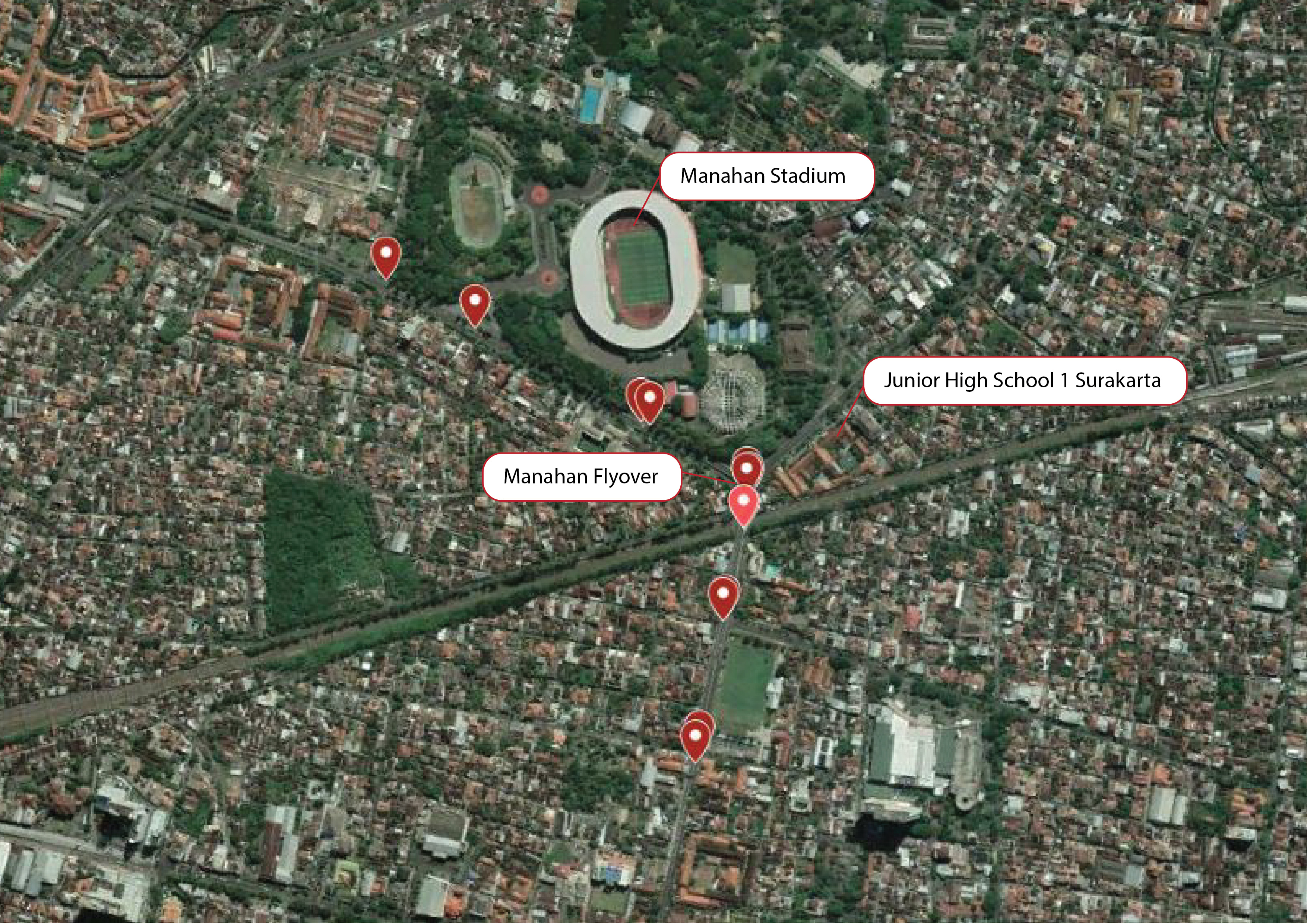
In Indonesia, Law No. 23 of 2007 about Railways mandated that level crossings shall be grade separated (underpass or flyover). As a result, in 2018, a flyover was built in Manahan in Surakarta City. The flyover was designed in a Y-shape with three legs to connect three roads that converge on the railway crossing. This design has road safety risks at the meeting point of the three legs and on the crossing facilities near the ramp. Flyover development has increased driver speeding behaviour due to the road geometry and traffic management changes. Since its opening, there have already been 12 crashes that have resulted in two deaths. Figure 1 shows the crash locations in the Manahan flyover area that were mainly dominated by crashes between a car and a motorcycle. There were also crashes where a motorcycle hit a pedestrian, and hit and run crashes between a motorcycle and a car.

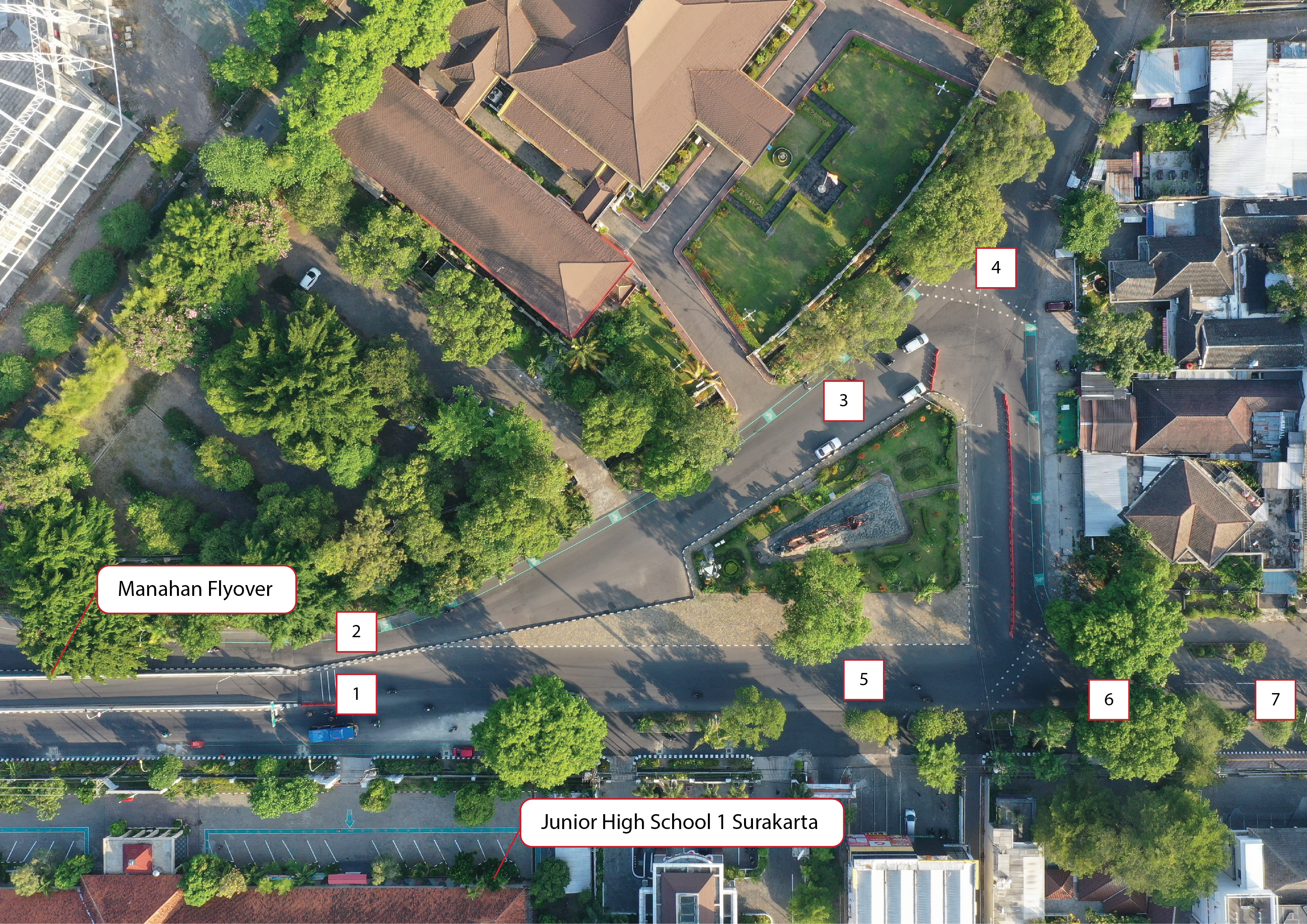
These crashes are not the only road safety problems around the Manahan flyover area. There are underlying road safety risks that impact Junior High School 1, which is located beside the north leg of the flyover. Even though no crashes have occurred in front of the school, some students experienced almost getting hit when crossing the street. The increasing risks, as shown in Figure 3, resulted from the flyover design that put the starting point of the flyover in front of the gate of the school and did not provide safe facilities for pedestrians.
The development of the flyover did not provide sidewalks or pedestrian crossings. The roads in front of the school are wide and difficult to cross with motor vehicles moving at high speed. Students instead choose the starting point of the flyover to cross the street and reach the school as it has the shortest distance to cross and provides curbs that are used as a temporary refugee island. The starting point of the flyover is used despite the increasing safety risks from high speed or speeding motor vehicles.
Indonesia has not yet implemented road safety audits and inspections for new infrastructure development in urban areas or school zones. So it is difficult to communicate latent road safety risks and urge the government to improve road safety. In recent years, a tool to assess road safety conditions, named International Road Assessment Programme (iRAP), has been developed and used globally, including in Indonesia. In school areas, iRAP has developed iRAP Star Rating for School (SR4S) that has been used in the Philippines and Malaysia.
In the Philippines, Gomintong et. al. (2021) found that tools such as SR4S empower researchers to conduct pedestrian safety assessments, identify possible improvements, measure impacts, and most importantly, effectively communicate these to stakeholders to bring improvements.
In Malaysia, the most critical factor was determined to be vehicle operating speeds and school sites with higher speeds were typically rated with low star ratings (Hoong et al., 2021). In addition to segregating pedestrians from road traffic by providing sidewalks, traffic calming measures and traffic wardens should be in place to manage the risk during the peak hours. A school facing a 1-star or 2-star road for example, should be given priority for safety upgrades – as simple as providing a traffic warden or installing speed humps. School sites with 3-star and above ratings are considered acceptable but further improvements will be needed as the traffic environment changes and vehicular volumes increase.
Both the aforementioned studies assessed road safety risk related to pedestrians, especially around schools. The Philippines study included three schools and the Malaysian study included 60 schools within the state of Selangor. Neither study involved youth as part of the road safety assessment which distinguishes the current study.
This study used the iRAP SR4S as a road safety inspection tool to assess school safety zones surrounding Junior High School 1 and engage youth from the school to participate in the assessment and discuss possible improvements. iRAP SR4S was chosen because it could be used as an analysis tool and to communicate the safety risks and the improvement needed to be measurable and easy to understand by the general public. These characteristics are beneficial for road safety advocacy to propose the improvement of road safety conditions to the government.
The objectives of this study were:
-
to assess school safety zones using iRAP SR4S through participatory design with youth;
-
to encourage youth voices to be part of the designing process;
-
to propose road safety improvement around the school to the government.
Method
Youth Participation
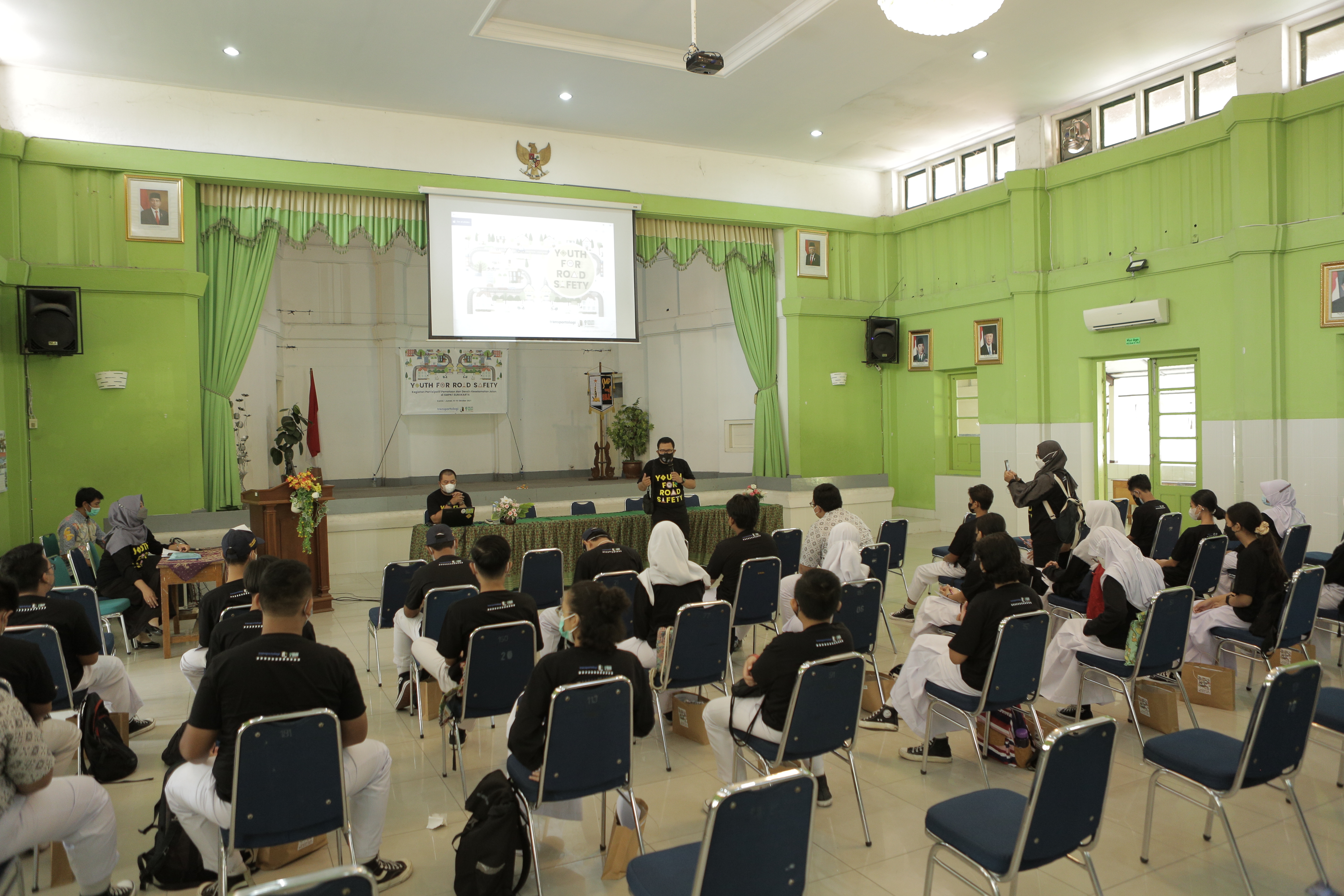
A participatory approach was used to ensure students’ needs were met. Facilitators from a non-government organisation named Transportologi were involved in engaging with the youth to assist, advise, improve knowledge, and guide participants in following the participatory process. There were five facilitators involved with 30 students who were divided into five groups. Activities included an interactive discussion through capacity building, knowledge transfer, surveys and workshops. The steps involved were as follows:
-
The facilitators empowered the students with basic knowledge of road safety and standard infrastructure needed to assess the school safety environment against the iRAP SR4S road attribute data (Figure 2).
-
The facilitators and students were accompanied by teachers to conduct the technical survey. This survey aimed to enable students to experience traffic conditions around the school. The students walked around the school to survey, conducted traffic counts for five minutes, and mapped the road problems related to safety.
-
The students and facilitators held an interactive discussion to map the problems within the groups. Based on the problems they found during the survey, the students developed possible solutions.
-
Each group presented their problems and solutions based on what they discovered during the survey and discussion. Those solutions were listed, mapped, and ranked to prioritise possible solutions. The next step was to use the problems and solutions listed by the group as part of the SR4S assessment.

The main problems found by the students were the lack of safer infrastructure, street obstacles for pedestrians, lack of safety awareness, poor infrastructure design and management, and lack of services (Table 1).
iRAP SR4S
SR4S methodology is part of the full iRAP model that focuses on measuring and mitigating risks to pedestrians. Focusing on one road user group, SR4S simplifies the risk assessment process somewhat and makes it easier to use in school communities around the world (iRAP, 2014b).
SR4S is the first evidence-based tool to measure, manage and communicate the risks children face while traveling to and from school. It objectively measures the road design star rating for pedestrians and safety before and after school improvements are implemented. Star ratings are calculated at specific locations using evidence-based studies of safety impacts, where 1-star is the least safe and 5-star is the safest. Once the risk is measured, effective road treatment countermeasures and their impact on safety can be simulated to identify cost-effective solutions (iRAP, 2014a).
Star ratings are determined by assigning Star Rating Scores (SRS) to the bands as shown in Table 2. Motorised road users (vehicle occupants and motorcyclists), bicyclists and pedestrians use different equations to calculate ratings, and therefore use different bands. In other words, motorised road user scores are based on head-on, run-off road and intersection crashes; pedestrian scores are based on walking along and across the road crashes; and bicyclist scores are based on riding along the road and intersection crashes (iRAP, 2013).
The SR4S coding guide provides guidelines for coding the attribute data that are part of the process of SR4S (iRAP, 2020). The road attribute data needed consists of:
-
Road environment (land use, area type, vehicle parking, sight distance);
-
Road type (number of lanes, lane width, shoulder rumble, road condition, grip, grade, carriageway type);
-
Road features (middle of road, lines and signs, street lighting);
-
School zone (school warning, school crossing supervisor);
-
Sidewalks (sidewalk presence, road edge, pedestrian fencing);
-
Pedestrian crossing (crossing on main and side road, crossing feature, crossing quality);
-
Traffic flow (vehicles/day, crossing flow/hour, pedestrian walk along/hour);
-
Intersections (intersection present, intersection type, intersection side flow, intersection quality, intersection channelisation);
-
Curve (curve presence, curve type, curve quality);
-
Speed (speed limit, operating speed, speed management).
Results
There were seven high-risk locations around the school to be assessed (Figure 3):
-
In front of the main gate of Junior High School 1;
-
Opposite Junior High School 1;
-
In front of the Women’s Building;
-
3-leg intersections at the Women’s Building;
-
3-leg intersections at the Tax Office;
-
4-leg intersections at MT. Haryono Street;
-
In front of the Church at MT. Haryono Street.

The seven high-risk locations impacted by Manahan flyover development was used as the survey locations. The coding was based on the field surveys with the students. The input data for coding were generated from the views of the students and their perspectives as road users. All the problems were mapped into the SR4S application. Using the SR4S application, six locations were rated 1-star or 2-star. Only one location was rated 3-star.
In accordance with the Global Road Safety Performance Targets to achieve a minimum 3-star rating (WHO, 2017), interventions were proposed in school zones such as improving signs and road markings, providing pedestrian crossings, reducing the speed limit to 30 km/h, enforcing the speed limit and applying a range of speed management solutions. Of all the potential interventions, speed reduction will provide the greatest increase in the level of safety. As shown in Table 3 and Figure 4, if all the proposed solutions were implemented all locations would be rated 4-star or 5-star and the estimated percentage reduction of pedestrian risk would be more than 90%.

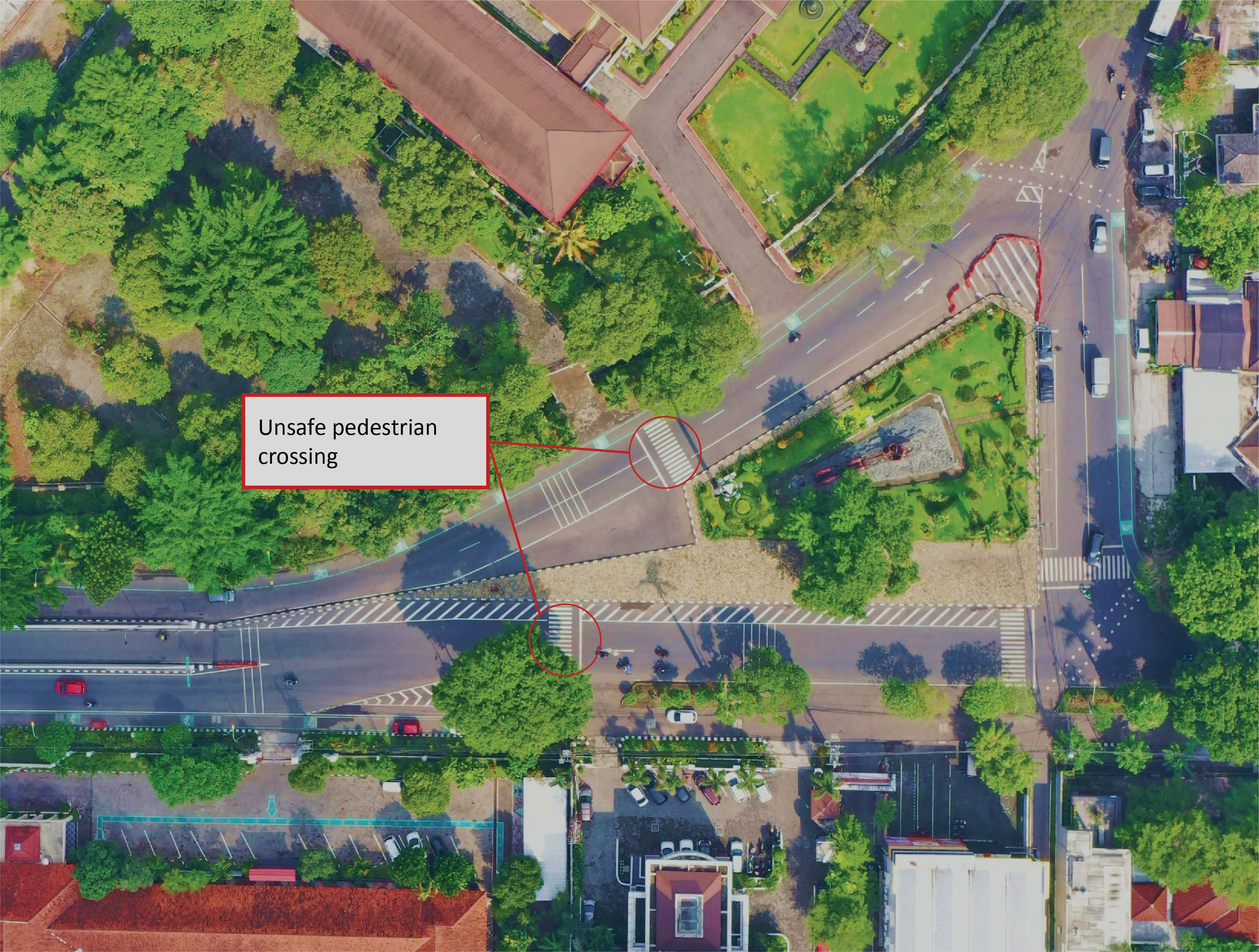
In addition to the student based activities described above, discussions were held with the school as well as the Government of Surakarta City to assess the potential recommendations that were considered feasible based on the capacity of the stakeholders. In October 2021, meetings with the Government of Surakarta, represented by the Local Planning Agency, were held to discuss the road safety situation in front of the school and the need to implement the interventions. Although the Government agreed to improve road safety around the school, of all of the proposed interventions they only installed road markings and two pedestrian crossings due to the limited budget in 2021 (Figure 5).

Discussion
The main problems identified in the Manahan flyover and school area consisted of the lack of safe infrastructure, street obstacles for pedestrians, lack of safety awareness, poor infrastructure design and management and lack of services. This study has successfully identified road safety improvements which would meet user needs based on a participatory design approach involving youth combined with iRAP SR4S analysis. The school and the research team provided the proposed solutions to the government but limited action was taken.
As mentioned in the Global Plan Decade of Action for Road Safety 2021-2030, youth play an important role in shaping the future transport system for two key reasons. First, they are the age group most affected by road trauma, with road traffic crashes being the leading cause of death among those aged 5-29 years. Second, they are the generations who will inherit the outcomes of decisions made today about the safety of the evolving transport system. Meaningful engagement with youth can help foster greater ownership of the road safety issue as well as develop a new cohort of road safety advocates with a fresh perspective on the future of mobility (WHO, 2021). By engaging youth, the solutions and interventions that meet their needs and experience will be accommodated as part of decision-making process. Furthermore, this will lead to the commitment of the students and stakeholders of the school to use the implemented interventions.
Study Limitations
The COVID-19 pandemic resulted in reduced pedestrian and vehicle traffic which could have affected the results. Secondly, there is no road traffic crash data available for Surakarta in order to assess the need for and effectiveness of interventions. Finally, the final star ratings provided in this paper assume full implementation of countermeasures. Due to the lack of budget and some political bureaucracy this was not the case. Future studies are suggested to assess the impact after the proposed interventions are fully implemented by the government.
Conclusions
Junior High School 1 Surakarta City is the first school in Indonesia to be officially assessed through the iRAP SR4S. The study demonstrated that the engagement of youth in identifying hazards that compromise their safety while walking to and from school and potential solutions via the SR4S tool is a meaningful technique for road safety planning around schools. The combination of qualitative and quantitative data form a powerful basis for planned advocacy with the government.
Acknowledgments
The research study reported in this paper was made possible through a grant from Global Youth Coalition for Road Safety under the Local Actions program. The authors thank Junior High School 1 Surakarta City, the Government of Surakarta City, Global Youth Coalition for Road Safety – Youth for Road Safety (YOURS), and the International Road Assessment Programme – Star Rating for Schools (iRAP SR4S). The authors also thank the reviewers for their constructive comments. The results and interpretation of the analysis are, however, completely the views of the authors.
Author Contributions
All authors contributed to the conception, design, analyses, and interpretation of results. Estiara Ellizar drafted the article and supported the iRAP SR4S analyses. Sukma Larastiti also support in drafting the article and work with Titis Efrindu Bawono for the conceptual study design, Windu Mulyana, and Cahyadi Kurniawan supported the execution of the workshop. All authors are responsible on the data collection throughout the project.
All authors have read and agreed to the published version of the article.
Funding
This work was supported by Global Youth Coalition for Road Safety as part of the Local Actions project. Our project was a Local Action Winner entitled “Safer Street Participatory Design with Youth”, which ran from May 2021 to March 2022 in Surakarta, Central Java, Indonesia.
Human Research Ethics Review
All subjects gave their informed consent for inclusion before they participated in the study. The study was conducted in accordance with the Declaration of Helsinki, and the protocol was approved by the Ethics Committee of Junior High School 1, Surakarta, proved by the Letter of Intent (LoI) between Transportologi and Junior High School 1, Surakarta, on May 19, 2021, with the reference letter number 01/01.B/Trans/V/2021 and 421.6/428/TU/V/2021.
Conflicts of interest
The authors declare that there are no conflicts of interest.
Data Availability Statement
Data supporting reported results can be provided on request to the corresponding author.
Article History
Received: 26/07/2022; Received in revised form: 28/10/2022; Accepted: 20/04/2023; Available online: 17/05/2023
This peer-reviewed paper was first submitted as an Extended Abstract and an Oral Presentation was recommended by two reviewers at the 2022 Australasian Road Safety Conference (ARSC2022) held in Christchurch, New Zealand 28-30 September 2022. The two reviewers also recommended that the Extended Abstract be expanded into a ‘Full Paper’ and undergo further peer-review as a journal submission by three independent experts in the field. The Extended Abstract is published in the ARSC2022 Proceedings. This ‘Full Paper’ version is being reproduced here with the kind permission of the authors and will only be available in this edition of the JRS.