


Introduction
The West Antarctic ice sheet is presently in a state of negative mass balance (Reference Chen, Wilson, Blankenship and TapleyChen and others, 2009) due largely to the eastern sector of the Amundsen Sea Embayment (ASE), which contains four major outlet glaciers (Smith, Haynes, Thwaites and Pine Island) that are accelerating (Reference RignotRignot, 2001, Reference Rignot2006, Reference Rignot2008; Reference Joughin, Rignot, Rosanova, Lucchitta and BohlanderJoughin and others, 2003, Reference Joughin, Smith and Holland2010) and thinning rapidly (e.g. Reference Shepherd, Wingham and MansleyShepherd and others, 2002; Reference ThomasThomas and others, 2004a; Reference Pritchard, Arthern, Vaughan and EdwardsPritchard and others, 2009). Understanding the mechanisms behind glacier acceleration in the ASE provides critical context for predictions of its future evolution (Reference Lemke and SolomonLemke and others, 2007). Further thinning of the floating extensions of these glaciers or other changes that reduce buttressing (e.g. rifting) could lead to additional acceleration of grounded ice (Reference Schmeltz, Rignot, Dupont and MacAyealSchmeltz and others, 2002; Reference Joughin, Smith and HollandJoughin and others, 2010) and grounding-line retreat (e.g. Reference RignotRignot, 2001). The latter is of particular concern because of the landward-sloping topography beneath these marine- based glaciers (Reference HoltHolt and others, 2006;Reference VaughanVaughan and others, 2006) rendering them dynamically unstable if groundingline retreat continues (Reference SchoofSchoof, 2007).
The amount of buttressing that an ice shelf or tongue provides to upstream grounded ice depends on how much shear is generated along its margins (bay walls or adjacent slower-flowing ice) and/or areas of localized grounding (e.g. ice rises), representing lateral and basal drag, respectively. These drags are functions of both contact area and friction. Enhanced delivery of Circumpolar Deep Water into the eastern Amundsen Sea over the last two decades has increased melt rates beneath Pine Island Glacier’s ice shelf (Reference Jacobs, Jenkins, Giulivi and DutrieuxJacobs and others, 2011). The resultant ice-shelf thinning has reduced both lateral and basal drag there and likely initiated its recent acceleration (Reference RignotRignot, 2002;Reference JenkinsJenkins and others, 2010); this process also appears to have affected the eastern ASE’s other outlet glaciers (Reference Schmeltz, Rignot and MacAyealSchmeltz and others, 2001).
While previous studies reported other changes in the ASE’s floating ice (e.g. increased rifting) that broadly suggest additional loss of lateral drag between 1972 and 2002 (Reference BindschadlerBindschadler, 2002;Reference Swithinbank, Williams, Ferrigno, Foley and RosanovaSwithinbank and others, 2003), these studies are limited either spatially or temporally. To understand better the evolution of ice-shelf buttressing in the eastern ASE, here we comprehensively document the satellite history of coastal change in the eastern ASE since 1972 and evaluate this coastal change in terms of reported glacier accelerations.
Data and Methods
Satellite data and coastline tracing
We compiled 158 Landsat scenes acquired over the eastern ASE between December 1972 and November 2011, some of which have been used in previous studies of coastal change in the eastern ASE (e.g. Reference BindschadlerBindschadler, 2002;Reference RignotRignot, 2002; Reference Swithinbank, Williams, Ferrigno, Foley and RosanovaSwithinbank and others, 2003, Reference Swithinbank, Williams, Ferrigno, Foley, Rosanova and Dailide2004). We separated these scenes by calendar year by dividing each austral summer into two periods across 1 January of each year. Using this approach we generated 44 mosaics and, where sufficient Landsat coverage was available, we produced multiple mosaics for a single period of the austral summer either before or after 1 January. We also compiled 38 European Remote-sensing Satellite (ERS) synthetic aperture radar (SAR) scenes available within our study area that were chosen to fill gaps in Landsat coverage of the ASE coastline between 1992 and 1998. From these scenes, we produced seven additional mosaics and analyzed them in the same manner as for the Landsat scenes. Available imagery is sparse before 1994 but available for every year thereafter. For Pine Island Glacier only, we include older coastline positions derived from 1947 and 1966 aerial photography (Reference RignotRignot, 2002) and 1963 satellite photography (Reference Kim, Jezek and LiuKim and others, 2007).
The available Landsat scenes were corrected radiometrically and geometrically (level 1G);Landsat-7 scenes (1997-2011) were also orthorectified (level 1Gt). No additional radiometric corrections were applied, nor was any contrast stretching necessary for image analysis. The spatio- temporal resolution of available digital elevation models (DEMs) and recent rapid thinning of eastern ASE outlet glaciers (e.g. Reference Pritchard, Arthern, Vaughan and EdwardsPritchard and others, 2009) limit the geodetic accuracy of these scenes. Our study is focused on floating ice, where surface slopes outside of crevasses/rifts are low, so inconsistent orthorectification introduces limited geodetic uncertainty.
We then traced the coastline in these Landsat and ERS SAR mosaics manually at a scale of 1 : 50 000 (Figs 1 and 2; Table 1;Animations 1-4). The spatial resolution of Landsat sensors improved over time from 60 m to 15 m. Although other later sensors often have finer resolution, a resolution of 30-60 m is sufficient to distinguish the calving front and/or rifts, and our Landsat-derived coastline traces agree well with contemporaneous traces derived from ERS SAR. For Landsat, we found that coastlines were often simplest to trace in color-infrared mode. An advantage of this approach is that color differences can be used to better distinguish floating ice masses attached to grounded ice from the ice melange or sea water visible inside rifts. A potential drawback is that for Landsat-7 (1999-present) we did not use the 15 m resolution panchromatic band 8. However, we found that delineation of the coastline was unaffected by the use of 30 m resolution data for the bands that form a colour- infrared image.
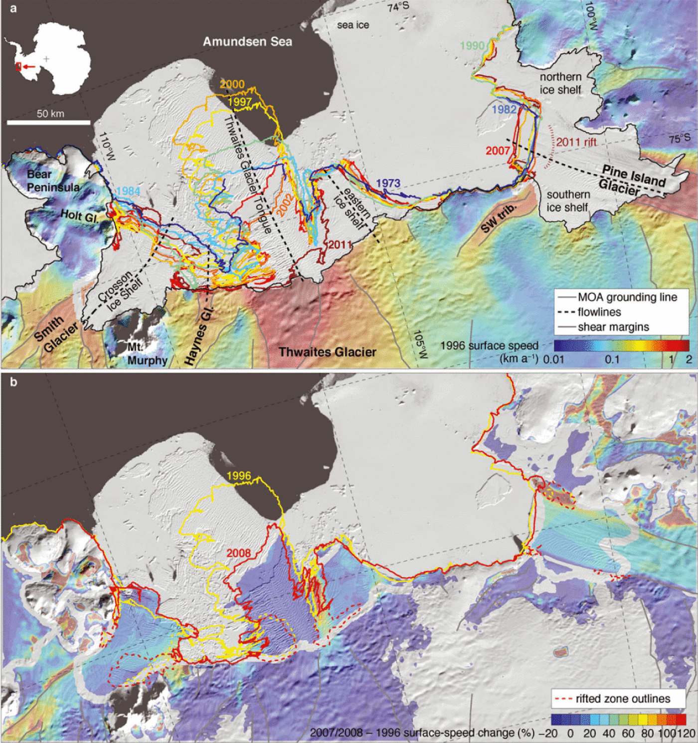
Fig. 1. (a) Evolution of the eastern ASE coastline between 1972 and 2011. Grayscale background is 2003-04 Mosaic of Antarctica (MOA). Superimposed coastlines are traced Landsat-1 through -7 imagery. For clarity, only nine out of 51 coastlines traced in this study are shown; Animations 1-4 show the complete coastline history. 1996 surface velocities (Reference JoughinJoughin and others, 2009) are shown only for ice upstream of the 2003-04 MOA grounding line (Reference Scambos, Haran, Fahnestock, Painter and BohlanderScambos and others, 2007). Shear margins on grounded ice were traced along coherent maxima in the absolute value of the lateral shear strain rate derived from the 1996 surface velocities. Key central flowlines are shown for the five major ice shelves and tongues in the eastern ASE. Inset map shows the location of the study area in Antarctica. (b) Percent change in surface speed between 1996 (Reference JoughinJoughin and others, 2009) and 2007-08 (Reference Rignot, Mouginot and ScheuchlRignot and others, 2011). The two coastlines bounding this period (1996 and 2008) are also shown, along with outlines of rifted zones at those times. The missing data across the grounding zone are due to missing 1996 surface speeds there. Note that the color scales are saturated to better illustrate the spatial variation of speed change and that portions of some slower-flowing regions (<50ma-1; e.g. Bear Peninsula) show large relative speed changes that are likely spurious.
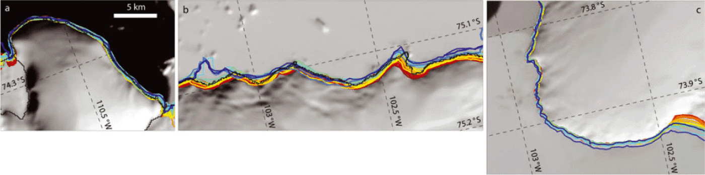
Fig. 2. Coastlines along portions of the eastern ASE coastline that were mostly stable between 1972 and 2011. (a) Bear Peninsula; (b) the coastline between Thwaites and Pine Island Glaciers; (c) Canisteo Peninsula. The coastlines of all 51 Landsat and ERS SAR mosaics are shown. The format of these maps and the coastline color scale are the same as for Figure 1 and the scale is the same for all three panels.
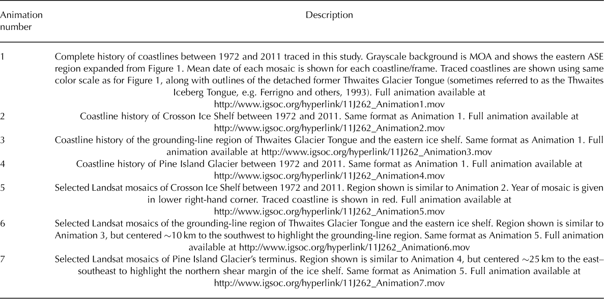
Table 1. Descriptions of online animations of coastline history and rifting evolution. Full animations available at www.igsoc.org/hyperlink
Where possible, we co-registered older scenes with newer ones using rock outcrops and slower-flowing portions of the coastline that either remained stationary or changed slowly throughout our study period (Fig. 2). We then adjusted the coastlines traced in the mosaicked imagery to produce the best possible co-alignment in these regions. With this approach, geodetic accuracy does not necessarily improve, but the relative positioning uncertainty between traced coastlines decreases significantly, as evidenced by the steady terminus advances (linear over time) that we measured along the central flowlines of the outlet glaciers (Fig. 3). These adjustments generally decreased over time as the georeferencing of satellite imagery either improved or became more self-consistent. No adjustments were made to scenes collected after 1997, but some 1972 scenes required adjustments of >20 km. Based on the residual mismatch between traces in regions that have a quasi-stable coastline (Fig. 2), we estimate our relative positioning uncertainty to be <0.5 km. The mean range of acquisition dates for the scenes that formed each Landsat mosaic is 15 days. For the maximum ice-flow speeds in this region (~4kma-1 on Pine Island Glacier in 2010), that mean date range is equivalent to a relative positioning uncertainty of <0.2 km.
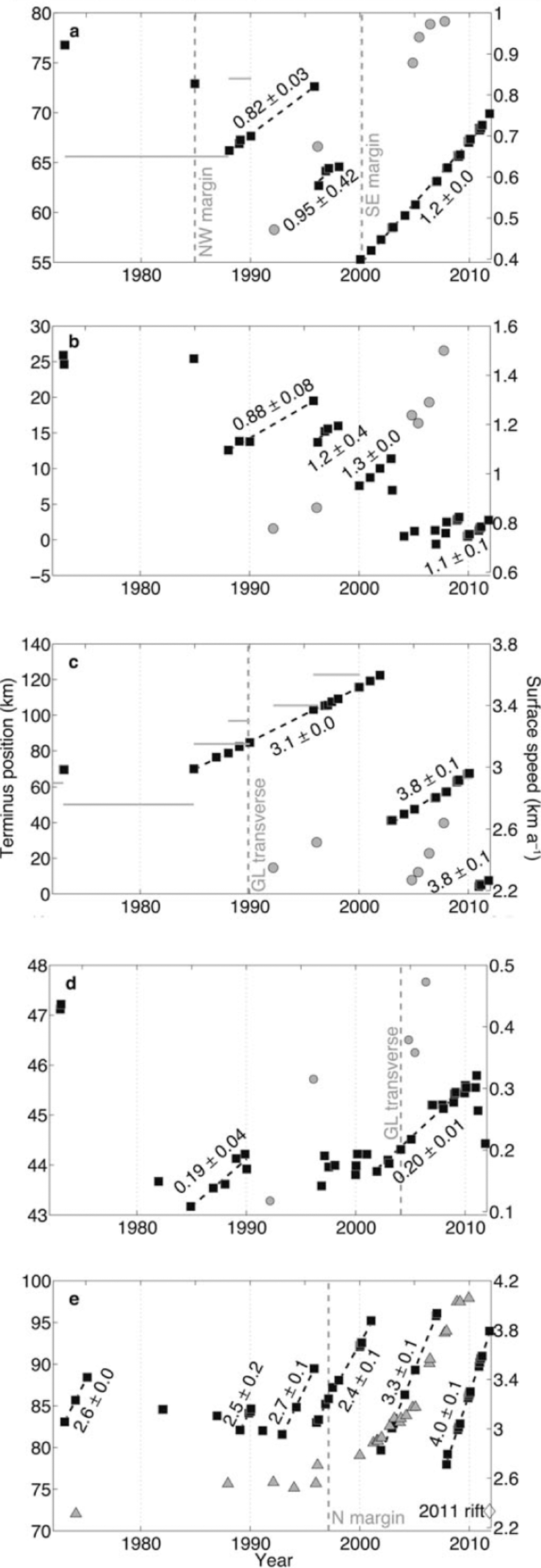
Fig. 3. Histories of terminus position and surface speed along flowlines of the eastern ASE’s major outlet glaciers between 1972 and 2011. (a) Smith Glacier/Crosson Ice Shelf; (b) Haynes Glacier; (c) Thwaites Glacier Tongue; (d) Thwaites Glacier’s eastern ice shelf; (e) Pine Island Glacier’s ice shelf. Terminus position is given as distance downstream of the grounding line along the flowline. Surface speeds are compiled from published interferometric SAR (InSAR), SAR speckle tracking and Landsat feature-tracking data (Reference Joughin, Rignot, Rosanova, Lucchitta and BohlanderJoughin and others, 2003, Reference Joughin, Smith and Holland2010; Reference RignotRignot, 2006, Reference Rignot2008). Where available, terminus speeds are shown for direct comparison with terminus advance rates; these speeds are shown as horizontal gray lines for longer measurement periods on Smith and Thwaites Glaciers and as triangles for shorter measurement periods on Pine Island Glacier. For Crosson Ice Shelf and Thwaites Glacier Tongue, the terminus speed is estimated as its maximum observed value during each study period (Reference Ferrigno, Lucchitta, Mullins, Allison, Allen and GouldFerrigno and others, 1993; Reference Lucchitta, Mullins, Smith and FerrignoLucchitta and others, 1994; Reference Rosanova, Lucchitta and FerrignoRosanova and others, 1998; Reference RignotRignot, 2001; Reference Lang, Rabus and DechLang and others, 2004; Reference JoughinJoughin and others, 2009; http://nsidc.org/data/velmap/pine_getz/thwaites/thwaites.html). For Haynes Glacier, the grounding-line speeds shown are the nearest available data along the western edge of Thwaites Glacier, where these two glaciers merge. Vertical gray dashed lines denote the onsets of major rifting events. Linear least-squares terminus advance rates are shown for each sufficiently well-sampled period of steady advance; uncertainties are the standard errors for a least-squares fit.
Along-flow terminus histories
From the imagery compilation and coastline tracing, we identified the terminus position through time along central flowlines of the eastern ASE’s four major outlet glaciers (Fig. 3). Flowlines were calculated using 1996 surface velocities derived from interferometric SAR (InSAR) and speckle tracking (Reference JoughinJoughin and others, 2009). Where those velocity data end, either at or upstream of the 1996 terminus, the flowline is extended along the last measured velocity azimuth. Terminus position along a flowline is the linearly interpolated intersection of the flowline with the traced coastline. Flowlines were chosen based on both the coverage of the 1996 surface velocity map and our goal of intersecting the maximum possible number of traced coastlines.
We evaluated two different methods for calculating terminus position over time. In the first method, we calculated the intersection of each flowline/coastline pair by linearly interpolating each vector defined by two consecutive flowline points and determining whether it intersected the equivalent linear interpolation of any two consecutive coastline points. The flowlines are smoothly varying, whereas the coastlines were manually traced with the assumption that the coastline is a straight line between individual points (mean distance between points of 206 m). In heavily rifted regions where the coastline is not smoothly varying, this assumption may break down.
The second method follows Reference Moon and JoughinMoon and Joughin (2008) who tracked the change in area of an open-ended box, the downstream end of which is the glacier terminus and the across-flow width of which is the majority of the glacier width. They argued that this ‘box’ method better accounts for terminus position changes than a single flowline. Because the width of most of the ice shelves in the eastern ASE is much larger than that of many of the Greenland outlet glaciers that Reference Moon and JoughinMoon and Joughin (2008) studied, and because of the nonuniform ice-shelf marginal retreat that we observed (e.g. Fig. 1), we tested the box method across Pine Island Glacier only (Fig. 4). It is easiest to interpret such a record for Pine Island Glacier because of its relatively simple terminus shape and we used a 21.5 km wide box that includes about two- thirds of the near-terminus width of the glacier.
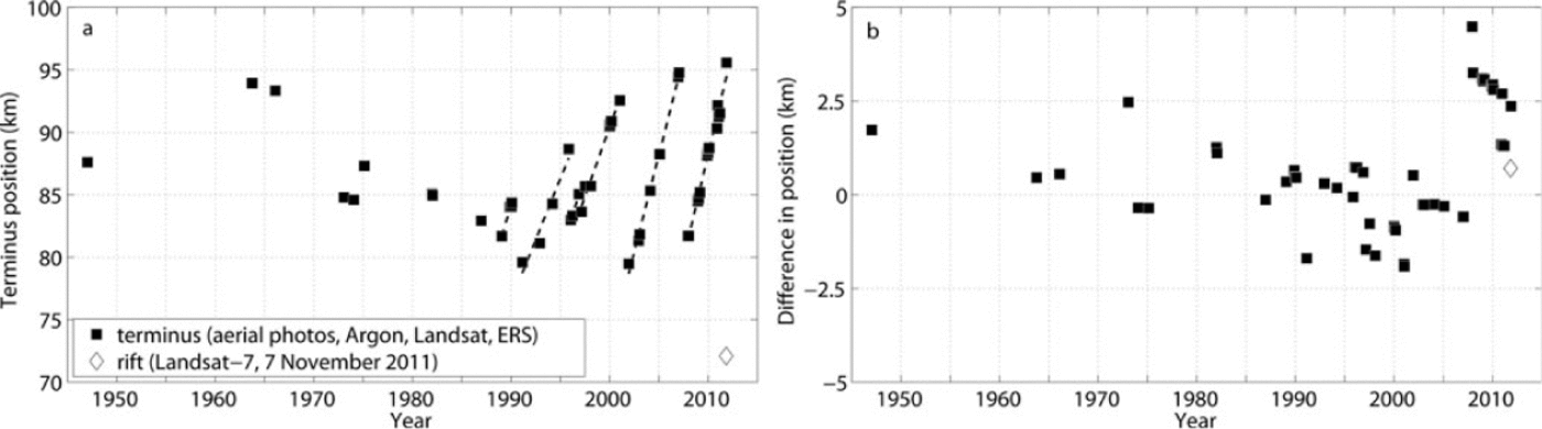
Fig. 4. (a) History of the terminus position of pine Island Glacier between 1947 and 2011 derived using a 21.5 km wide open-ended box instead of the flowline method show in Figure 3e. (b) Difference between box- and flow line-derived terminus positions
Although the box method is a better representation of the behaviour of the Pine Island Glacier terminus as a whole, it produced a noisier record whose terminus advance rates do not agree as well with existing surface speed data. This result is consistent with expectations, in that by including more of the terminus in the calculation of its along-flow position, the box method captures more small calving events. The box method is affected more strongly by the limited satellite coverage earlier in our study period, where coastline traces occasionally end abruptly along a terminus of interest (e.g. Animation 1). The compromises required in such cases result in terminus positions derived using the box method that are not directly comparable. We therefore chose to use the simpler flowline method to report terminus histories of the glaciers that we studied (Fig. 3).
Coastal Evolution
Our terminus histories exhibit sawtooth patterns of steady advance punctuated by periodic calving (Fig. 2). The terminus position along all central flowlines in late 2011 has either retreated or is about to retreat (in the case of Pine Island Glacier) further upstream than compared with late 1972 or early 1973. In addition to this long-term retreat, we observe more rapid, non-periodic terminus retreat along the margins of the ice shelves downstream of all four outlet glaciers. In all cases, marginal rifting precedes this retreat (Fig. 5;Animations 5-7). Below we describe the coastal evolution of each glacier system from west to east.
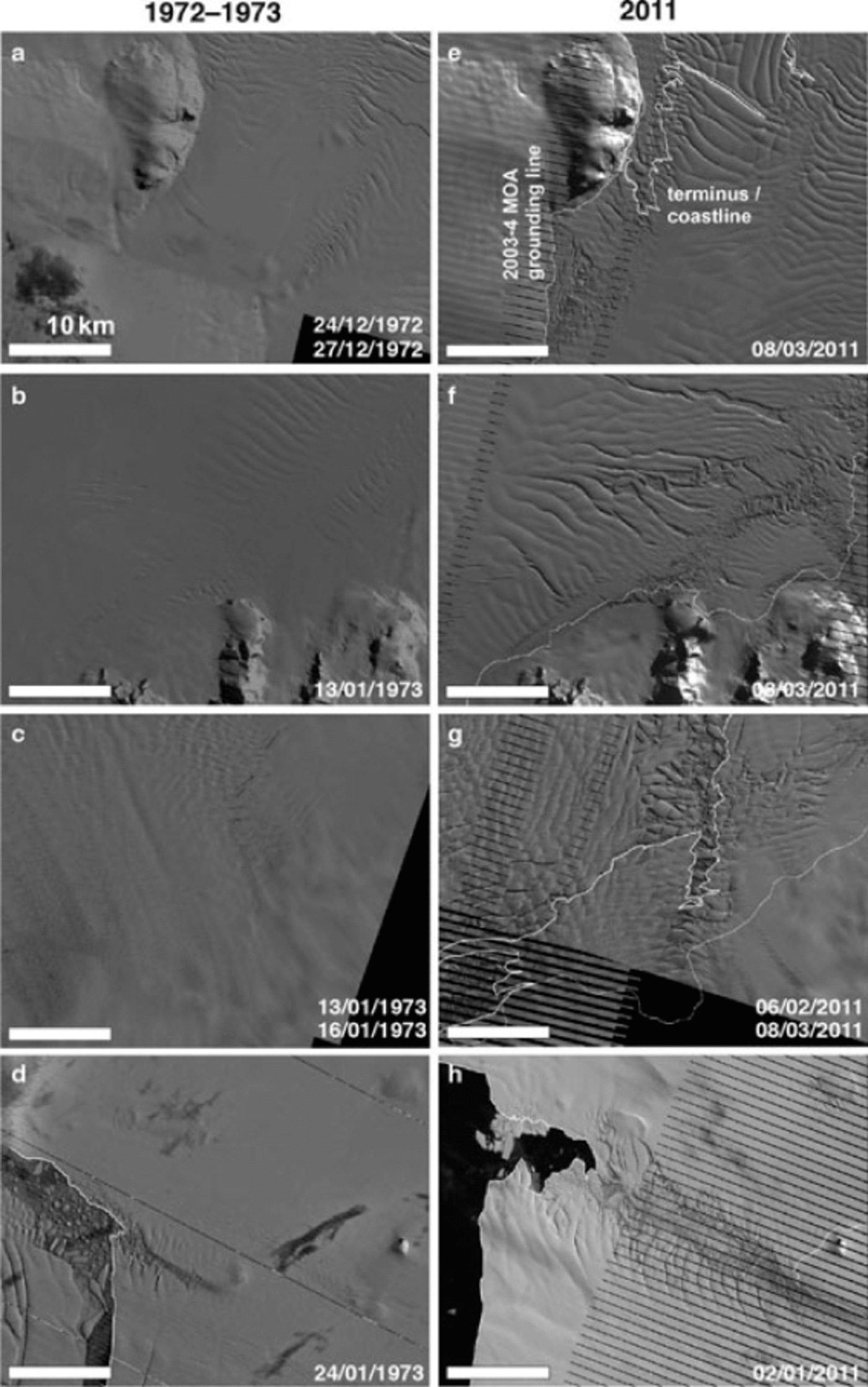
Fig. 5. Pairs of Landsat scenes showing the eastern ASE’s marginal ice-shelf changes between 1972 and 2011. (a, e) The Crosson Ice Shelf (northwestern margin); (b, f) Crosson Ice Shelf (southeastern margin); (c, g) Thwaites Glacier Tongue; (d, h) Pine Island Glacier’s ice shelf (northern margin). Scene acquisition dates (dd/mm/yyyy) are given in lower right-hand corner of each panel. Note the resolution difference between scenes from 1972–73 (60 m) and 2011 (30m shown here). The same scale is used for all panels. The striping visible in the 2011 scenes is due to an unrepaired malfunction in the Landsat-7 platform that occurred in 2003.
Smith Glacier is buttressed by Crosson Ice Shelf, which is confined along its northwestern and southeastern margins by Bear Peninsula and Mount Murphy/Haynes Glacier, respectively. Since 1984, Crosson Ice Shelf has progressively rifted and detached from Bear Peninsula both in the vicinity of Holt Glacier (Fig. 5a and e; Animation 5) and further upstream, leading to terminus retreat along that margin. By 2011, the terminus along the northwestern margin was 24 km further upstream than in 1990, and <10 km of the length of the northwestern margin of Crosson Ice Shelf remained attached to Bear Peninsula. Along this ice shelf’s opposite margin next to Mount Murphy, rifts elongated, widened and increased in density beginning in 2000. As of late 2011, this rifting is widespread along at least a 28km long portion of the margin between the terminus and the 2003-04 Moderate Resolution Imaging Spectroradiometer (MODIS) Mosaic of Antarctica (MOA) grounding line along the northeastern flank of Mount Murphy. In 1972, two ice rises were apparent ~6km north of the flowline shown in Figure 1 (Reference Lucchitta, Mullins, Smith and FerrignoLucchitta and others, 1994);the downstream ice rise appears to have ungrounded by 1996 and the effect of the upstream ice rise disappeared after 2007. Our observations of marginal rifting, terminus retreat and ungrounding of Crosson Ice Shelf are coincident with a doubling in speed of Smith Glacier at the grounding line after 1992 (Reference RignotRignot, 2006, 2008) (Fig. 3a). Some of the highest rates of speed-up on Crosson Ice Shelf between 1996 and 2007-08 (>500 m a-1) are focused at, or upstream of, the marginal rifting and retreat we observed (Reference RignotRignot, 2008;Fig. 1b).
In 1973, the ice shelf of Haynes Glacier loosely connected Crosson Ice Shelf and Thwaites Glacier Tongue, but it has progressively disintegrated since 1984 (Animation 5) and since 2004 its terminus has remained at or near its grounding line. As a result, any lateral drag that the ice shelf of Haynes Glacier once provided to either of these ice masses has been lost. The 1992-2008 acceleration of the eastern margin of Haynes Glacier (Reference RignotRignot, 2006, Reference Rignot2008) is contemporaneous with the later stages of its ice shelf’s disintegration, but appears to have continued after its terminus stabilized near the grounding line (Fig. 3b), which suggests that driving stress has also increased on Haynes Glacier since 2004. However, the slowdown across its central trunk between 1996 and 2007-08 (Reference RignotRignot, 2008; Fig. 1b) and the lower rate of its most recent terminus advance suggest that much of the response of its central trunk to ice-shelf disintegration occurred before 1996.
Where Thwaites Glacier goes afloat, it forms two distinct floating ice masses: (1) Thwaites Glacier Tongue, which is downstream of the central area of fastest flow;and (2) the eastern ice shelf, which extends east of the ice tongue and was partially connected to it until 2010 (Fig. 5c and g; Animation 6). A pinning point ~45 km downstream of the eastern ice shelf’s grounding line restricts its flow (Reference RignotRignot, 2001;Reference Tinto and BellTinto and Bell, 2011), causing deceleration between its grounding line and terminus (Fig. 3d) and inducing shear between the ice tongue and ice shelf. The floating ice between these two ice masses originates where a major shear zone emerges from Thwaites Glacier (Reference RignotRignot, 2001, Reference Rignot2006) and is an area of recent acceleration (Reference RignotRignot, 2008; Fig. 1b). Rapid upstream propagation of the terminus in this narrow region began in 2009 and the terminus is now 26 km further upstream than in 1973 and is within ~4km of the grounding line. After 1989, transverse-to-flow rifts grew in size and density near the grounding line of Thwaites Glacier, particularly along its western flank (e.g. Reference RignotRignot, 2001); similar rifts appeared near the grounding line of the eastern ice shelf in 2001 (Reference RignotRignot, 2006). In 2010, Thwaites Glacier Tongue calved within 16 km of the grounding line, although the new ~2240km2 iceberg and the smaller remaining ice tongue are presently still connected by an ice melange. Thwaites Glacier Tongue is not believed to buttress Thwaites Glacier significantly (Reference RignotRignot, 2001), which is consistent with the muted recent acceleration of the grounded ice directly upstream of the ice tongue (up to 16% between 1992 and 2007;Reference RignotRignot, 2006, Reference Rignot2008; Fig. 3c) compared with other glaciers in the ASE (63-108% over the same period), despite similar observations of marginal rifting and terminus retreat. The terminus advance rate did not change significantly after the 2010 calving event, which removed most of the remaining ice tongue; this observation supports the earlier calculations of its limited buttressing effect.
Pine Island Glacier is buttressed by an ice shelf whose flow is resisted primarily by shear along the adjacent slower- flowing southern and northern ice shelves (Reference RignotRignot, 2002; Reference Schmeltz, Rignot, Dupont and MacAyealSchmeltz and others, 2002). An ice rise that existed prior to 1982 formerly provided additional resistance to flow (Reference JenkinsJenkins and others, 2010). The northern shear margin of this ice shelf has progressively rifted apart since 1997 (Reference BindschadlerBindschadler, 2002), and rifts now extend along a 21 km long zone from the 2011 terminus to the grounding line (Fig. 5d and h;Animation 7). This rifting originates at two ice rises (Reference BindschadlerBindschadler, 2002);since 2002 the downstream ice rise no longer clearly generates rifts, suggesting that the ice shelf has progressively ungrounded there. Consequently, since 2008 the terminus has retreated across this narrow rifted zone. A loss of buttressing along the northern margin has been predicted to result in a 20% increase in terminus speed (Reference Schmeltz, Rignot, Dupont and MacAyealSchmeltz and others, 2002), so rifting alone cannot explain the observed ~60% terminus acceleration between 1996 and 2010 (Reference Joughin, Rignot, Rosanova, Lucchitta and BohlanderJoughin and others, 2003, Reference Jenkins2010; Reference RignotRignot, 2006, Reference Rignot2008) (Fig. 3e) that models have suggested is due primarily to ungrounding of an ice plain (e.g. Reference ThomasThomas and others, 2004b). The southern margin of the ice shelf has retreated similarly, although the ice there is much less fractured near its terminus, which is consistent with observed greater acceleration along the northern margin of the ice shelf relative to its southern margin (Reference RignotRignot, 2008; Fig. 1c). Rifting along the southern shear margin 40-60 km upstream of the terminus began in 1999. The difference in degree of fracturing between the northern and southern shear margins is presumably due to the lack of ice rises along the southern margin (Reference RignotRignot, 2002).
Discussion
Ice flux across the grounding line is less sensitive to ice-shelf buttressing than it is to ice thickness there (Reference SchoofSchoof, 2007), hence most recent studies of floating ice in the eastern ASE have focused on the pattern of sub-ice-shelf melting (Reference JenkinsJenkins and others, 2010;Reference Jacobs, Jenkins, Giulivi and DutrieuxJacobs and others, 2011) and its role in grounding-line ice dynamics (Reference Joughin, Smith and HollandJoughin and others, 2010). Our observations indicate that ice-shelf marginal rifting and terminus retreat along these rifted margins were widespread in the eastern ASE between 1972 and 2011, particularly beginning in the late 1990s. Ice melange within these rifts is expected to support much less force transmission between opposing rift faces than would have existed prior to rift formation (Reference MacAyeal, Rignot and HulbeMacAyeal and others, 1998). Therefore, these changes must have reduced the lateral drag of the ice shelves, although ice-flow acceleration and spatially varying thinning may have partially counterbalanced their effect by increasing lateral drag. The spatio-temporal resolutions of ice-flow speed and ice-shelf thinning histories during our study period preclude quantification of buttressing loss in the eastern ASE, or a conclusive apportionment of this buttressing loss between ice-shelf thinning and margin disintegration. However, reported accelerations are generally contemporaneous and spatially coherent with these marginal changes, strongly suggesting that this pattern of coastal change also reduced buttressing and contributed to acceleration of upstream grounded ice.
A sequence of ice-shelf thinning, acceleration, marginal rifting and disintegration was proposed to explain the 19982003 acceleration of Jakobshavn Isbra, Greenland (Reference JoughinJoughin and others, 2008). The major outlet glaciers of the eastern ASE have recently undergone elements of this same sequence, although only Haynes Glacier’s ice shelf has completely disintegrated so far. This acceleration was likely initiated by two mechanisms: (1) redistribution of driving stress towards the grounding line due to enhanced sub-ice- shelf melting near there (Reference SchoofSchoof, 2007);or (2) decreased ice- shelf buttressing due to loss of basal and lateral drag as thinning ice shelves ungrounded from ice rises and reduced their contact area with side walls. We hypothesize that the development and growth of marginal rifts is favoured during periods of ice-shelf thinning and outlet glacier acceleration. Thus, the accelerations of these glaciers have apparently led to an additional form of buttressing loss: decreased ice-shelf lateral drag due to marginal rifting. Continued acceleration should lead to further rifting, potentially creating a feedback until all lateral resistance to ice-shelf flow is lost.
We hypothesize that rifting is favoured along the ice-shelf margins because these regions were once shear margins within grounded ice further upstream (Fig. 1). Shear margins are expected to be rheologically weaker (Reference Echelmeyer, Harrison, Larsen and MitchellEchelmeyer and others, 1994;Reference MacAyeal, Rignot and HulbeMacAyeal and others, 1998;Reference Khazendar, Rignot and LarourKhazendar and others, 2007) and have numerous surface crevasses that may connect with basal crevasses forming at the grounding line to create rifts (Reference Catania, Conway, Raymond and ScambosCatania and others, 2006). Ice-shelf thinning promotes basal crevasse growth (Reference Van der VeenVan der Veen, 1998) and is widespread in the ASE (e.g. Reference Schmeltz, Rignot and MacAyealSchmeltz and others, 2001; Reference ZwallyZwally and others, 2005;Reference JenkinsJenkins and others, 2010), so the marginal rifting we report may not be due solely to acceleration or pre-existing weakness.
This slower style of ice-shelf disintegration and the hypothesized underlying mechanisms are distinct from the much faster (multi-day) catastrophic disintegrations of the Larsen A/B and Wilkins ice shelves in the Antarctic Peninsula, which are believed to have been induced by surface-meltwater-enhanced fracture propagation and iceberg capsizing (Reference Scambos, Hulbe, Fahnestock and BohlanderScambos and others, 2000, Reference Scambos2009; Reference MacAyeal, Scambos, Hulbe and FahnestockMacAyeal and others, 2003). However, pre-existing rifts may also have weakened those ice shelves and influenced the extent of those faster disintegrations (e.g. Reference Khazendar, Rignot and LarourKhazendar and others, 2007). We speculate that margin-led rifting is a common feature in the non-catastrophic break-up of thicker ice shelves since it seems to occur whenever these ice shelves accelerate significantly relative to their margins. Such acceleration can originate in several different ways, and ice-shelf margins are often zones of inherited weakness. Reference JakobssonJakobsson and others (2011) proposed that the late-Pleisto- cene collapse of a large ice shelf in the present-day Amundsen Sea was initiated by rapid sea-level rise and involved grounding-line rifting. Both marginal and grounding-line rifting are occurring presently in the ASE (e.g. Thwaites Glacier) and the former generally precedes the latter, so marginal rifting may also have played a role in the late-Pleistocene event.
Outlook
Along with the potential continuation of enhanced Circumpolar Deep Water delivery into the ASE (Reference Steig, Ding, Battisti and JenkinsSteig and others, 2012), which would lead to further sub-ice-shelf melting, several observations of the present configuration of floating ice in the eastern ASE suggest that reductions in buttressing will continue. First, since 2000, large transverse rifts across Crosson Ice Shelf have begun to propagate from the southeast and now extend across two-thirds of its width. If these rifts continue to grow, its downstream half will calve off and its terminus will be further upstream than at any other time since 1972. Second, if the eastern ice shelf of Thwaites Glacier calves in the vicinity of transverse rifts near its grounding line, as Thwaites Glacier Tongue did in 2010, the buttressing currently provided by the pinning point at its terminus will be lost (Reference RignotRignot, 2006). Third, if terminus retreat along the southern margin of Pine Island Glacier’s ice shelf continues, its southwestern tributary will lose any buttressing provided by direct contact with the southern ice shelf. The rift that developed in late 2011 across Pine Island Glacier’s ice shelf is further upstream than any previously observed terminus position, including its first sighting in 1947 (Reference RignotRignot, 2002;Reference HowatHowat and others, 2012; Figs 1 and 4a). However, it does not appear that the calving of this portion of the ice shelf will result in any substantial additional buttressing loss, due to pre-existing marginal rifts. Rifting often occurs in the lee of ice rises and can destabilize ice- shelf flow (e.g. Reference Doake and VaughanDoake and Vaughan, 1991), but as ice shelves thin they also unground from ice rises and no longer generate rifts, so any further rifting in the eastern ASE will likely nucleate at ice-shelf margins or the grounding line (e.g. Thwaites Glacier).
Two modelling challenges that arise from our observations are the accurate portrayal of the style of progressive margin-led ice-shelf disintegration that we observe throughout the eastern ASE, and evaluation of its potential feedback with outlet glacier acceleration. So far, this style of buttressing loss has only been simulated in this region for Pine Island Glacier by instantaneously removing portions of its ice shelf (Reference Schmeltz, Rignot, Dupont and MacAyealSchmeltz and others, 2002;Reference Joughin, Smith and HollandJoughin and others, 2010). The effect of rifts upon the flow of the Filchner-Ronne Ice Shelf has been simulated successfully using diagnostic finite-element modelling (e.g. Reference MacAyeal, Rignot and HulbeMacAyeal and others, 1998), but additional work is necessary to include marginal rifting and its effects in predictive ice-sheet models. This work should include both field and remote-sensing studies of the internal glacier stresses that likely dominate marginal rift evolution (e.g. Reference Bassis, Fricker, Coleman and MinsterBassis and others, 2008) and modelling studies of the effect of marginal rifting upon ice-flow evolution (e.g. Reference Vieli and NickVieli and Nick, 2011). Accurate modelling of calving rates is another outstanding challenge in glaciology (Reference AlleyAlley and others, 2008), and prediction of calving in the eastern ASE using ice-flow models can be improved using the histories of terminus position presented here.
Acknowledgements
This work was supported by the US National Science Foundation (ANT 0739654). We thank I. Joughin for providing 1996 surface velocities, the US Geological Survey for access to the Landsat archive, and the Alaska Satellite Facility and the European Space Agency for access to their respective ERS SAR archives. We thank the scientific editor (H. Fricker), J. Amundson, E. Rignot and three anonymous reviewers for constructive comments on the manuscript.


