Geographic areas with the highest concentration of traffic accidents in San Salvador, El Salvador: a spatial analysis of the period 2014-2018
DOI:
https://doi.org/10.17843/rpmesp.2023.404.12963Keywords:
Traffic Accidents, Accident Prevention, Geographic Information Systems (GIS), El Salvador, Central AmericaAbstract
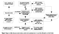
Objective. This study aimed to identify the areas with the highest concentration of traffic accidents and injuries in the San Salvador Metropolitan Area (SSMA). Materials and methods. Traffic accidents were analyzed spatially by point location and by the sum of events in areas of 200 m2. The point location was analyzed by “nearest neighbor analysis”, while the areas with the sum of traffic accidents were analyzed by Getis-Ord Gi* to obtain the hot spots. The resulting hot spots with the highest concentration of traffic accidents in the SSMA were evaluated in the field using an observation form to collect data on infrastructure and road safety characteristics. Results. Five areas with the highest number of traffic accidents and injuries, mainly containing primary roads, were identified by analyzing 8191 traffic accidents reported between 2014-2018. Conclusion. The sites with the highest concentration of traffic accidents and injuries were characterized by considerably damaged road infrastructure and the lack of safety systems for drivers and pedestrians. The spatial analysis of traffic accidents and injuries can contribute to improve surveillance and road safety in the SSMA.
Downloads
References
World Health Organization (WHO) [Internet]. Global Status Report on Road Safety 2018. Geneva: Health Organization; 2018. [Citado el 6 de junio de 2023]. Disponible en: https://www.who.int/publications/i/item/9789241565684.
Organización Panamericana de la Salud (OPS). Estado de La Seguridad Vial En La Región de Las Américas 2019. [Citado el 30 de octubre de 2023]. Disponible en: https://www3.paho.org/hq/index.php?option=-com_content&view=article&id=15237:status-of-road-safety-in-the-region-of-the-americas-2019&Itemid=0&lang=es#gsc.tab=0.
LA Network [Internet]. Ranking Latinoamericano de ciudades fatales. 2017. [Citado el 6 de junio de 2023]. Disponible en: https://la.network/ciudades-latinoamericanas-muertes-vias/
Medina E, Kaempffer AM. Consideraciones epidemiológicas sobre los traumatismos en Chile. Revista Chilena de Cirugía. 2007; 59(3): 175-184. Disponible en: https://pesquisa.bvsalud.org/portal/resource/pt/lil-464994.
Viceministerio de Transporte (VMT). Portal de Transparencia, 2021. [Citado el 30 de octubre de 2023]. Disponible en: https://www.transparencia.gob.sv/institutions/vmt/documents/estadisticas.
Ministerio de Salud de El Salvador, Instituto Nacional de Salud. Tendencia de lesiones de causa externa: accidentes de tránsito, El Salvador. Periodo 2012 – 2015. 2017. [Citado el 30 de octubre de 2023]. Disponible en: https://pesquisa.bvsalud.org/portal/resource/pt/biblio-1100217.
Chicas Molina JC. El difícil camino a la ordenación urbana del Área Metropolitana de San Salvador: una revisión crítica a los planes urbanos del AMSS 1953-1997. AKADEMOS. 2019; 2(33). doi: 10.5377/akademos. v0i0.9511.
Ministerio de Medio Ambiente y Recursos Naturales (MARN). Zonificación ambiental y usos de suelo de la subregión metropolitana de San Salvador, 2018. [Citado el 30 de octubre de 2023]. Disponible en: http://rcc.marn.gob.sv/xmlui/handle/123456789/355.
Gómez-Barroso D, López-Cuadrado T, Llácer A, Palmera Suárez R, Fernández-Cuenca R. Análisis espacial de los accidentes de tráfico con víctimas mortales en carretera en España, 2008-2011. Gaceta Sanitaria. 2015; 29:24–29. doi: 10.1016/j.gaceta.2015.02.009.
Harirforoush H, Bellalite L. A new integrated GIS-based analysis to detect hotspots: A case study of the city of Sherbrooke. Accident Analysis & Prevention. 2019; 130:62–74. doi: 10.1016/j.aap.2016.08.015.
Leveau C, Ubeda C. Muertes por lesiones de tránsito en Argentina: un análisis espacial para el período 2001–2009. Rev Panam Salud Publica. 2012; 31(5):4. [Citado el 30 de octubre de 2023]. Disponible en: https://iris.paho.org/handle/10665.2/9318.
Dos Santos AMR, Rodrigues RAP, Dos Santos CB, Caminiti GB. Geographic distribution of deaths among elderly due to traffic accidents. Esc Anna Nery. 2016; 20(1):103-137. Disponible en: https://www.scielo.br/j/ean/a/DqjGKST58rtB35p8FW6GFxt/?format=pdf&lang=en
Afshar F, Seyedabrishami S, Moridpour S. Application of Extremely Randomised Trees for exploring influential factors on variant crash severity data. Scientific Reports. 2022; 12(1):11476. doi: 10.1038/s41598-022-15693-7.
Bassani M, Rossetti L, Catani L. Spatial analysis of road crashes involving vulnerable road users in support of road safety management strategies. Transportation Research Procedia. 2020; 45:394–401. doi: 10.1016/j.trpro.2020.03.031.
Ministerio de Economía (MINEC). Encuesta de Hogares de Dirección General de Estadística y Censos DIGESTYC Propósitos Múltiples 2019. [Citado el 30 de octubre de 2023]. Disponible en: https://www.bcr.gob.sv/documental/Inicio/vista/PUBLICACION_EHPM_2019.pdf.
Adams M, Corr D, Requia W. Mapping Air Pollution Health Risk: An Application of Canada’s AQHI. Pp. 359–372 in Briassoulis H, Kavroudakis D, Soulakellis N (eds). The Practice of Spatial Analysis. Cham: Springer International Publishing. 2019. doi: 10.1007/978-3-319-89806-3_17.
Kobo Toolbox [Internet]. [Citado el 06 de junio de 2023]. Disponible en: https://www.kobotoolbox.org.
Rolison JJ, Regev S, Moutari S, Feeney A. What are the factors that contribute to road accidents? An assessment of law enforcement views, ordinary drivers’ opinions, and road accident records. Accident Analysis & Prevention. 2018; 115:11–24. doi: 10.1016/j.aap.2018.02.025.
Stephan KL, Newstead SV. Characteristics of the Road and Surrounding Environment in Metropolitan Shopping Strips: Association with the Frequency and Severity of Single-Vehicle Crashes. Traffic Injury Prevention. 2014; 15(sup1): S74–S80. doi: 10.1080/15389588.2014.930450.
Viceministerio de Transporte (VMT) [Internet]. Ley de Transporte Terrestre, Tránsito y Seguridad Vial. 2011. [Citado el 6 de junio de 2023]. Disponible en: https://www.vmt.gob.sv/documentos/?wpdmc=normativa-en-consulta.
Environmental Systems Research Institute [Internet]. Cómo funciona Vecino más Cercano Promedio. 2021. [Citado el 30 de octubre de 2023]. Disponible en: https://desktop.arcgis.com/es/arcmap/latest/tools/spatial-statistics-toolbox/h-how-average-nearest-neighbor-distance-spatial-st.htm.
Environmental Systems Research Institute [Internet]. Cómo funciona Análisis de puntos calientes (Gi* de Getis-Ord). 2021. [Citado el 30 de octubre de 2023]. Disponible en: https://pro.arcgis.com/es/pro-app/latest/tool-reference/spatial-statistics/h-how-hot-spot-analysis-getisord-gi-spatial-stati.htm.
Zhang G, Yau KKW, Chen G. Risk factors associated with traffic violations and accident severity in China. Accident Analysis & Prevention. 2013; 59:18–25. doi: 10.1016/j.aap.2013.05.004.
Hernández V. Análisis exploratorio espacial de los accidentes de tránsito en Ciudad Juárez, México. Rev Panam Salud Publica. 2012; 31(5): 396-402. [Citado el 30 de octubre de 2023]. Disponible en: https://www.paho.org/journal/sites/default/files/06--ARTI--HHernandez--396-402.pdf?ua=1.
Viera do Bonfim C, Galdino Soares da Silva A, Maria de Araújo W, Alencar C, Alencar Furtado BM. Análisis de la distribución espacial de los accidentes de transporte terrestre atendidos por el Servicio Móvil de Urgencia (SAMU-192), en un municipio de la región nordeste de Brasil. Salud Colectiva. 2018; 14(1):65–75. doi: 10.18294/sc.2018.1211.
Wang W, Yuan Z, Yang Y, Yang X, Liu Y. Factors influencing traffic accident frequencies on urban roads: A spatial panel time-fixed effects error model. PLoS ONE. 2019; 14(4):e0214539. doi: 10.1371/journal.pone.0214539.
Castro Delgado F. Análisis espacial de los accidentes de tránsito en el Cantón de Pococí. Revista Geográfica De América Central. 2011; 2(47E). [Citado el 30 de octubre de 2023]. Disponible en: https://www.revistas.una.ac.cr/index.php/geografica/article/view/2091.
Al-Ghaweel I, Mursi SA, Jack JP, Joel I. Factors affecting road traffic accidents in Benghazi, Libya. Journal of Family & Community Medicine, 2009; 16(1):7–9. [Citado el 30 de octubre de 2023]. Disponible en: https://www.ncbi.nlm.nih.gov/pmc/articles/PMC3377020/pdf/JFCM-16-7.pdf.
Toval-Ruiz C, Rojas-Roque C, Hernández-Vásquez A. Predictors and geographic analysis of road traffic accidents in Leon, Nicaragua. Rev Bras Epidemiol. 2020; 24: e210003. doi: 10.1590/1980-549720210003.
Dukic T, Ahlstrom C, Patten C, Kettwich C, Kircher K. Effects of Electronic Billboards on Driver Distraction. Traffic Injury Prevention. 2013; 14(5):469–476. doi: 10.1080/15389588.2012.731546.
Aguero-Valverde J. Multivariate spatial models of excess crash frequency at area level: case of Costa Rica. Accident; Analysis and Prevention. 2013; 59:365–373. doi: 10.1016/j.aap.2013.06.014.
Quinteros E, Ribó A, Mejía R, López A, Belteton W, Comandari A et al. Heavy metals and pesticide exposure from agricultural activities and former agrochemical factory in a Salvadoran rural community. Environ Sci Pollut Res. 2016; 24(2):1662–1676.
Zelaya S, Mejía R. Mortalidad y años de vida potencialmente perdidos por enfermedades no transmisibles en El Salvador, 2011-2015. Revista Alerta, Instituto Nacional de Salud de El Salvador. 2018; 1(1): 42-52. doi: 10.5377/alerta.v1i1.6589.
Downloads
Published
Issue
Section
License
Copyright (c) 2023 Roberto Mejía, Edgar Quinteros, Alexandre Ribó Arnau

This work is licensed under a Creative Commons Attribution 4.0 International License.
How to Cite