


Abstract
Globalization is often associated with deforestation, but its impacts on forest recovery are less known. We analyzed socioeconomic data, land-use surveys, and satellite imagery to monitor changes in woody cover in El Salvador from the early 1990s to the present. Even where rural population density exceeded 250 people per square kilometer, we documented a 22% increase in the area with more than 30% tree cover, and a 7% increase in the area with more than 60% tree cover. Woodland resurgence reflected processes including civil war, retraction of the agricultural frontier, and international migration and associated remittances. Agrarian reform, structural adjustment, and emerging environmental ideas also played a role in woodland dynamics. Remittances may be especially important for woodland recovery in El Salvador, enabling people in rural areas to buy food without all of them needing to grow and sell it. This study adds to our understanding of the complexity of land-use change in emerging globalized economies and of potential conservation approaches for inhabited landscapes.
Globalization drives a great deal of deforestation in tropical Latin America, but in certain conditions it can effect forest recovery. Many analysts have failed to note the extent of woodland recuperation, in part because of their justifiable concerns about deforestation and in part because of a broader intellectual emphasis in tropical science on tropical old-growth forests. For most of the last half-century, the discourse about tropical clearing, and much of the intellectual and policy apparatus of conservation organizations, has been dominated by Malthusian and frontier models that highlight the negative effects of human settlement on forests. However, these approaches often are inadequate for explaining land-use change that is attributable to globalization or that occurs in regions with a long history of human occupation (Hecht 2005).
Globalization refers to the integration of countries and economies into international circuits of commodities, capital, labor, technology, and information. As part of what is now known as the “neoliberal consensus,” trade liberalization policies and structural adjustment reforms opened up economies to international commerce and de-emphasized the state in favor of market mechanisms to drive development. These policies include privatization of parastatal corporations, elimination of tariffs and subsidies, and reorganization of banking and credit systems. Democratization and institutional changes in national governance, such as curtailment of state programs and greater administrative decentralization, are often part of the adjustment programs. Globalization and national policies play out at local levels and in livelihood strategies as households adapt to changes in their circumstances and opportunities. Although neoliberal policies make national economies much more open and more subject to international forces than to local demand, new institutional arrangements can privilege local autonomy. These complexities at the local level give globalization a diverse range of outcomes.
Most studies of globalization have focused on its financial and business implications, with relatively little attention to its impacts on natural resources. In many areas, globalization has affected agricultural land use through the extension of large-scale industrial farming, a process that has reduced demand for traditional forms of labor and lowered the prices of agricultural commodities, often leading to a rural exodus (Rudel 2002, Aide and Grau 2004, Hecht 2005). In Latin America, armed conflicts, natural catastrophes, and the economic and social allurements of city life have created additional momentum for rural migration. These changes have led to complex outcomes: In some cases, agricultural lands have been abandoned; in others, they have been incorporated into specialized commercial systems such as those for organic coffee or off-season vegetables. In still other cases, farmers have shifted away from field crops and into domestic horticulture while working for wages in nonagricultural parts of the economy (Rudel 2002, Chazdon 2003, Klooster 2003). In many cases, rural people have migrated to other countries.
Like other parts of the world (Kauppi et al. 2006), the Latin American tropics show extensive areas of natural and anthropogenic forest recovery in populated areas, including the Caribbean (Rudel et al. 2000, Aide et al. 2001), Mexico (Bray et al. 2003, Klooster 2003), Ecuador (Rudel et al. 2002), and parts of Amazonia (Perz and Skole 2003, Neeff et al. 2006). These fallows, coffee forests, agroforestry systems, tenure demarcations, dooryard gardens, secondary successions, abandoned pastures, and modified forest remnants provide numerous and vital environmental services. At the global level, they are rapid absorbers of atmospheric carbon dioxide and thus are an important element in the global carbon cycle (DeFries et al. 2000, Houghton et al. 2000, Castro et al. 2003). Such landscapes are more biodiverse than was previously thought (Perfecto et al. 1996, Komar 1998, Harvey and Haber 1999, Harvey 2000, Perfecto and Vandermeer 2001, Barrance et al. 2003, Angulo and García 2005, Phillips et al. 2006). They buffer declines in regional diversity and are extensively used by old-growth species (Daily et al. 2001, 2003, Komar 2003, Mayfield and Daily 2005). At local scales, they moderate stream flows, mediate local microclimates (Lawton et al. 2001), and provide important intermediate habitats for crop pollinators (Brown and Albrecht 2001, Ricketts 2004). Anthropogenic forested landscapes throughout the tropics provide socially and economically important subsistence and market goods to rural households (Chazdon and Coe 1999, Bray et al. 2003). Despite conservationists' preference for large-scale megareserves (Peres 2005), it is clear that complex matrices of inhabited and “countryside” landscapes will be increasingly important for the long-term conservation of biodiversity as large continuous areas become more scarce. These woodlands thus form an active element in the diversity of complex landscapes.
In Central America, as in most of the tropics, the analysis of forest cover has focused on the loss of old-growth forests, and has largely ignored anthropogenic patterns of forest recovery (FAO 2001). Land-use changes can, however, be very dynamic, and they are not always unidirectional. In this study, we focus on changes that contribute to forest recovery, and examine the underlying social and economic forces. Our study concentrates on El Salvador because it is an especially interesting case: (a) It is widely assumed to have been almost completely deforested by the end of the 1970s (Durham 1979); (b) the quality of the historical and current economic statistics is among the best in the region; (c) data on social history and landscape changes are comprehensive; and (d) the relevant satellite imagery for quantifying land-use changes is extensive. These circumstances permit detailed exposition of some dynamics that are likely to be more generalized throughout Central America and elsewhere in the peasant landscapes of Latin America's tropics, and they suggest some parameters to explore for understanding the forest trend.
Our study integrates recent economic and social history with several types of remote-sensing satellite imagery to quantify and understand the trajectories of forest recovery. The data encompass several periods: the late 1970s, when deforestation was at its peak; the late 1980s to the end of the civil war in 1992; and the early 2000s, almost 10 years after the signing of the peace accords. These are distinct periods of changes in the country's land use and political and economic systems. We will outline the dominant events of each period and then present the data on the dynamics of land cover. The last section discusses the broader implications of our findings for practical conservation policies.
History of land-use change in El Salvador
During the 1970s, the expansion of the agro-industrial, livestock, and peasant agricultural frontiers in Latin America involved frequent, violent conflict and produced rapid and extensive deforestation (Leonard 1987, Hecht and Cockburn 1989). This was especially the case in Central America, where this expansion contributed to land conflicts and to the region's civil wars. By the end of the 1970s, less than 6% of El Salvador's natural forest was considered undisturbed (Leonard 1987, Utting 1993). During the 1980s, El Salvador was embroiled in civil conflict that lasted from 1980 to 1992. The war shaped a context that ultimately had several effects on the environment, on the political economy of the country, and on land-use policy.
Of war and woods
There is good reason to worry about the impacts of wars on the environment. The destruction of the landscape through carpet bombing, the slaughter of wildlife, and the use of biocides all can generate ghastly environmental consequences and horrendous human suffering (Dudley et al. 2002). This is especially true in Africa, where ivory, gold, precious woods, animal pelts, and bush meat have funded clashes and supported native armies. In Central America, however, conflicts were proxies in cold-war politics and supported with generous outside funding, which meant that local resources were not plundered as they were in Africa. Although we do not support war as a conservation policy, there are situations in which conflict can actually lead to ecosystem protection. Martin and Szuter (1999) claimed this point accounted for the abundance of the wildlife observed by Lewis and Clark. There are also modern cases: The demilitarized zone between North and South Korea (Kim 1997) and the resurgence of forests in Mozambique (Kreike 2003) after extensive land mining are but two. In both of these situations, residents systematically retreated from dangerous landscapes in war zones, thus reducing human impacts on the biota.
In El Salvador, the rapid expansion of industrial agriculture, peasant farming, and livestock frontiers sharply declined as the countryside became too perilous, rife as it was with periodic carpet bombing and massacres. Violence and terror stimulated urban migration and a surge of international flight. About one-sixth of the population left the country, mostly for the United States (Kandel 2002). The consequent contraction of cropping and ranching triggered a rural exodus that allowed successional recuperation of pasture and crop fields for more than a decade. Food imports substituted for local grains, and international provisioning networks became well developed, further reducing subsistence pressures on the landscape and on the remaining forests (Hecht et al. 2006). Moreover, the rebels used the forest itself as a strategic defense, and mountain zones hid hospitals, command posts, and supply caches.
The peace accords of 1992 introduced political and policy changes that altered the role of agriculture and natural resources in the national economy. As part of the political and economic arrangements imposed after the war, a suite of neoliberal policies was implemented. These, as we noted earlier, emphasized market- rather than state-led forms of development, focused on urban–industrial sectors, promoted trade liberalization for food imports, and sharply limited credit to rural areas, all of which undermined the markets, economic support, and returns for small farmers (Cuellar et al. 2002, Hecht et al. 2006). By 2000, the real return to agriculture had contracted to 27% of its value in the 1970s (figure 1), creating a strong disincentive to produce, with the cost of production for most crops exceeding the profits that could be realized from them. The area in production of field crops also contracted (Hecht et al. 2006).
Although agricultural exports had been the main source of foreign exchange for all of El Salvador's history, by the 1990s, farming had ceased to be the dominant economic sector. The civil war was part of this process; when land was expropriated during agrarian reform, protection of urban and financial assets became a higher priority than rural development for economic elites. Experts in international development urged the retooling of El Salvador as a financial platform for Central America and the creation of low-wage assembly factories, or maquiladoras. The national development model shifted from export agriculture to one based on industrial and banking services, even as half the population remained rural.
Changes in forest cover over time
The periods we studied had quite different effects on the forest cover in El Salvador. We used satellite imagery from before the time of the peace accords in the early 1990s to the early 2000s to quantify changes in forest area. For this period, we used two independent but complementary data sets, derived from (1) high-resolution Landsat Thematic Mapper (TM) imagery, and (2) AVHRR (Advanced Very High Resolution Radiometer) and MODIS (Moderate Resolution Imaging Spectroradiometer) imagery. The data sets were used to map areas of tree cover for each period and changes in those areas as a result of shifts in land use.
Before we discuss the results of the analysis, it is important to clarify the definition of woodland in this study. By “woodland,” we mean a land area of more than 0.5 hectares (ha), dominated by woody vegetation and with a canopy cover of more than 10%. This definition has been used by the Food and Agriculture Organization of the United Nations, the World Bank, and other institutions in the region, and it provides a measure for quantitative estimates of such forests from remote-sensing data. This also helps avoid the semantically fraught complexity of the unqualified use of the word “forest.”
Chronosequences of Landsat imagery over many tropical regions are not widely available because of continuous cloud cover and limited data acquisition. In this study, we obtained orthorectified Landsat data for two periods of the early 1990s and 2000s from the Global Land Cover Facility (http://glcfapp.umiacs.umd.edu). Four images from Landsat TM from 1987 to 1990 covered the early 1990s, and four enhanced TM images from 1999 to 2002 were used for the early 2000s. All images were collected during the dry season to avoid cloud cover, rain, differences in illumination geometry, and large crop signatures. The analysis followed three steps: preprocessing, image classification, and development of a modified soil-adjusted vegetation index (MSAVI).
Preprocessing.
This step included the conversion of Landsat TM bands to units of radiance using prelaunch and updated calibration coefficients (Price 1987), derivation of a vegetation index, image mosaicking for wall-to-wall coverage of the country, and geographic registration of 1990 and 2000 images using standard methods available from the literature (Song et al. 2001).
Image classification.
We used training data from field observations to classify image mosaics into land-cover types: forest/woodland (including old-growth, closed-cover, and secondary forest; field demarcations; and plantations) and nonforest (including grass, low shrubs, and croplands). The classification was performed with the standard maximum likelihood estimation approach at 30-meter (m) spatial resolution and was verified and improved using existing maps and field data provided by the Ministry of the Environment and Natural Resources in El Salvador. The final classification accuracy was approximately 95%, suggesting a reliable distinction of woodlands from other land-use units.
Development of a modified soil-adjusted vegetation index.

This ratio enhances the intensity of vegetation index variations, while reducing landscape and topographic effects. The evolution of the change in the vegetation index between the two dates was then quantified by using thresholds on the histogram of the ratio image. The change threshold was fixed at ±1 standard deviation. The result of this approach is shown in figure 2a. To quantify the extent of forest resurgence in El Salvador, we overlaid the MSAVI change detection image with maps of forest cover from the classification approach (figure 2b).
Data on areas of forest clearing and resurgence, derived from the Landsat analysis, are given in figure 3. The results suggest that during the 1990s, El Salvador experienced a deforestation rate of 2.88%, a rate higher than was reported for the previous decade during the civil war (2.3%). But the woodland recovery rate was 5.8%, and thus the country had a net increase in woodland. These patterns were spatially divergent. The expansion of urban areas; the clearing of coffee plantations in response to economic volatility and to the decline of coffee prices; and natural disturbances such as forest fire (associated with the 1998 El Niño), landslides, hurricanes, and earthquakes affected forest cover, but the overall area of woodland increased in the 1990s, with the main pattern of woodland resurgence occurring in relatively small patches as crop and grazing lands reverted to woodlands throughout the country. This process occurred in all of the complex geographies of El Salvador, ranging from mangroves to high-altitude mixed conifer forests, but it was concentrated (as we document) in areas with greater remittances.
Changes in tree cover
The analysis of percentage tree cover derived from the AVHRR data for the early 1990s and the MODIS data for the early 2000s further supports the results from Landsat imagery. These images were generated with the continuous field approach of vegetation analysis that estimates the subpixel percentage tree cover (Hansen et al. 2002, Hansen and DeFries 2004). After cross-calibrating the two data sets, we extracted percentage tree cover from AVHRR data at 1-kilometer (km) resolution and from MODIS data at 500-m resolution. Given the uncertainties in estimating lower percentages of woody cover when using this approach, we decided on 30% and 60% thresholds of percentage tree cover as the conservative and stringent limits to the analysis of changes of forest area in El Salvador (table 1). Comparison with ground data and the Landsat classification results for approximately the same period suggested that the 30% threshold for the subpixel forest cover included all areas of mixed agroforestry crops, tree covers, orchards, pasture recovery, successions, and open woodlands. The 60% threshold, on the other hand, separated out areas with denser and contiguous patches of forest, mainly woodlands and tree plantations (figure 3). The thresholds had two objectives: (1) to separate changes in areas of low-density and high-density woody vegetation, and (2) to incorporate a larger error margin for the derived products of percentage tree cover from satellite data.
The difference in forest cover of the entire country between the two data sets showed increases of 4800 (± 100) and 1400 (± 100) km2 in the areas of 30% and 60% tree cover categories, respectively. Such increases occurred in all provinces at the 30% level, and in most of the provinces at the 60% level. In terms of the entire country, these changes translated into a 22% increase in the area of 30% tree cover, and a 6.5% increase in the area of denser forests with greater than 60% tree cover. The 6.5% rise in areas of higher-density woody vegetation over a decade reflected the expansion of secondary forests and woodlands. Our estimate of a 22% increase in areas of low-density woodlands is in line with other MODIS land-cover classifications of Central America, such as that of Giri and Jenkins (2005).
Our visual interpretation of images and the data in table 1 suggest that the largest increase in woody vegetation occurred in northern provinces, in mountainous zones at the edge of agricultural frontiers, and in regions that had been under the control of the Farabundo Martí Front for National Liberation, many of whose partisans fled the country to avoid being killed. The metropolitan area of San Salvador and coastal zones that were sites of urban expansion and road developments had, not surprisingly, more pronounced rates of clearing. The more compelling question regarding these differences is what drives the recent woodland recovery in landscapes with dense population.
Remittances and forest recovery
The widespread transfer of monies from foreign workers to their home countries—remittances—is among the largest of global capital flows, about 100 billion dollars a year (Gammeltoft 2002), and occurs throughout Africa, the Middle East, Asia, and Latin America. The implications of migration and the rise of remittance economies are a central topic for scholars of immigration policy and transnational studies, but very little research has focused on the relationship of these monies to the environment. In El Salvador, the exodus of a sixth of the population created the conditions for transfer of funds from working expatriates to their family members who remained in the country. International remittances came overwhelmingly from the United States, and accounted for 66% of the foreign exchange revenues of El Salvador (about $2.6 billion). These were received in 25% of all rural households (Kandel 2002). These capital flows “from below” basically doubled incomes in the El Salvador–based families of migrants. Remittances have done more to reduce poverty than did any other policy (Segovia 2002,Adams and Page 2005, Acosta et al. 2006).
The analysis of satellite imagery allowed us to test the relative impact of population and remittances on forest cover. We compared changes in woody vegetation derived from satellite data (table 1) in each province with population data, the distribution of average remittances, and the percentage of households receiving them. Malthusian theory would predict that, in rural areas, greater population density would correlate with less or no forest recovery or with more deforestation. Our comparison, however, showed no significant correlation of forest cover with population density and a statistically significant positive correlation of forest resurgence with remittances (figure 4). For every percentage point increase in remittances, there is a 0.25 increase in the percentage of land with 30% or more tree cover at a Pearson correlation of R = 0.49 (p = 0.02). This correlation improved to 0.68 (p = 0.004) in the 60% tree cover category. A similar trend of forest change with remittances was obtained from the Landsat analysis (figure 4a).
Households with remittances also cleared less land. The data suggested a negative correlation of R = 0.73 (p = 0.002) for forest clearings with increasing household remittances (Hecht et al. 2006). These findings have important implications for development, the environment, and rural poverty in Central America.
Transnational migration has been especially marked in Central America, and remittance flows, where they are substantial, often eclipse direct foreign investment and go directly to households. Table 2 shows the net migration and the value of remittances for Central America and Mexico. Although Mexico is somewhat aberrant because NAFTA (North American Free Trade Agreement), US–Mexico border development, and petroleum have elicited large-scale investments, the table clearly reveals that remittances were a much larger source of “foreign” capital than foreign investment in many Central American countries—often by orders of magnitude—and are significant parts of the gross domestic product. Indeed, in countries such as Nicaragua, remittances make up more than a third of the national income.
Where farming investments are viable, remittances may flow to them and either increase clearing or intensify production. But when agricultural prices are low (as they have been for grains), volatile (as they are for coffee), or high-risk (as they are for nontraditional crops such as berries and vegetables), remittances are often used for human capital investments: health, housing, food, education, and small-scale investments in commerce. In spite of substantial remittances between 1990 and 1997, production of maize, beans, sorghum, and rice showed an average decline of 17% (Hecht et al. 2006). Remittances, wages in nonagricultural endeavors, and collapsing agricultural prices help explain forest resurgence in El Salvador, but they have been complemented by other processes whose influence on land use was more subtle.
Agrarian reform and the new environmental ideologies
Agrarian reform has been one of the central political issues in Central and Latin America, and virtually all insurgencies, revolutions, and rebellions over the last century have been linked to questions of land distribution. The Central American wars of the 1970s and 1980s were no exception, and El Salvador's civil war was inflamed by demands for equitable land reform. The redistributive reforms El Salvador has undergone are among the most thoroughgoing in Central and Latin America; in their various phases, they have permitted both collective and private holdings, as well as legally defined areas of communal management.
The agrarian reforms of the 1980s and the peace accords distributed 401,232 ha—a fifth of the national territory—to 120,597 beneficiaries. About 25% of the rural households in El Salvador received land under the programs. This far-reaching reform had four main effects on natural resources at the institutional, ecological, technical, and philosophical levels. Institutionally, the reform secured land titles. Earlier, clearing the land was the way to claim the holding, which stimulated deforestation, whereas the new reforms provided legal security even for wooded lands. Reforms also motivated institutional changes in territorial organization at the local and regional levels, and affected natural resources through forest comanagement, fire control, watershed councils, and hunting controls. These kinds of institutional structures and mixes of tenure regimes have been key in promoting sustainable landscapes elsewhere in Latin America (Bray et al. 2003).
The ecological repercussions of the reforms arose through the creation of complex, multiuse, and multipurpose agricultural landscapes. For example, small farms of less than 7 ha represent 80% of all individual farms (about 18,500) and are integrated into mixed-production systems that supply coffee and ancillary products such as fruits, artisanal inputs, forage, medicines, and fuelwood for cooking; species diversity stands at more than 100 vascular species per ha (Méndez and Bacon 2005, Méndez et al. 2007). These small farms have an important role in household provisioning and create a highly structurally and ecologically diverse countryside, especially because El Salvador's coffee forests maintain a much more diverse overstory than is characteristic for most of Central America, and are largely low-input or organic systems (Méndez et al. 2007). On El Salvador's coastal plains, remote-sensing data revealed the greatest clearing (and least recovery) in areas of sugarcane cultivation. Land holdings on the coastal plains are among the largest in the country, and agro-industrial production there has been subsidized.
At the technical level, many of the agrarian reform communities were served by national and international nongovernmental organizations whose assistance focused on farming systems that emphasized sustainable agroecology models, including agroforestry and multicropping systems. The agrarian reform movement was thus strongly integrated into a kind of environmentalism that sought to maintain and support woody resources within populated landscapes. Given the terrain, copious rainfall, and easy erodibility of the soil, protection of populated landcapes was given priority.
The rise of environmental discourse in tropical development has also been an increasingly salient feature of the last couple of decades. El Salvador's reputation as an environmental basket case made it imperative that issues of sustainability, ecological integrity, and reforestation become important parts of the policy discussions at the national level (Government of El Salvador 1999). In general, the environmental rhetoric at the governmental level emphasized conservation and favored traditional reserve or park set-aside models over the more “biosocial” approach that focused on peasantries and inhabited landscapes. Both models were integrated into international assistance and lending programs during the 1980s and 1990s, and these, in turn, supported the emergence of local and national movements that used variants of the sustainable-development or set-aside approaches to seek funding and allies. The impact of each is quite different, however. While El Salvador's largest national park, El Imposible (about 5000 ha), and other conservation areas (about 15,000 ha) remained static in area, our analysis showed that inhabited landscapes increased their forest cover. This regrowth now exceeds the overall area of the parks and has the potential to expand further.
Conservation in set-asides and in inhabited landscapes can be complementary, but the former approach has well-developed sets of policies, scientific apparatus, and funding conduits, whereas the dynamic, unprotected inhabited woodlands are subject to much less policymaking, social analysis, and scientific attention even though they have conservation, environmental, and social value. In addition, the rise in discussions of transfer payments for environmental services has been a means of adding value to these anthropogenic forests. Many communities have organized themselves to try to take advantage of emerging markets in these services (Dimas et al. 2003, Grieg-Gran et al. 2005, Pagiola et al. 2005). El Salvador has impressive levels of biodiversity (Berendsohn 1995, MARN 1999, Komar 2003, Hecht 2004, Méndez et al. 2007), and given the relatively small area in conservation units (about 2% of the country), much of this diversity is supported by numerous and highly variable anthropogenic landscapes in biotic zones that range from mangroves to cloud forests.
Forest resurgence is generally “below the radar” in the tropics. However, in El Salvador and elsewhere, woodland recovery is driven by substantial integration into globalized processes, whether of politics (cold war), commodity markets (cheap grains, coffee), economic policies (structural adjustment), social equity (agrarian reform), ideas (environmentalism), labor (migration), technologies (agroecology), or financial flows (remittances). These elements, in varying configurations, have shaped the dynamics of woodland recovery in the Latin American tropics, but how public policies, local organizations, and market mechanisms might enhance resurgence still needs much more analysis.
Implications for conservation
We know processes of forest recovery are occurring throughout the tropics, but the ways these unfold need to be specified, so more localized policies that support inhabited forest landscapes can be added to the existing repertoire of conservation approaches. Globalization has created substantial income crises among peasant farmers throughout Latin America, especially indigenous and montane dwellers; although globalization can be salutary for woodlands, it is arduous for rural people. Given this political economy, many rural dwellers see their future less as producers of crops than as generators of environmental services at global and national levels, and they seek integration of inhabited landscapes with other systems of conservation set-asides and resource corridors (Lungo et al. 1997). Rural people are still the managers of most of the world's tropical landscapes and natural resources. Uncovering situations in which their conservation effectiveness can be enhanced—and in which they can be rewarded for actions that protect the environment—should increasingly attract the attention of policymakers and development practitioners, because doing so would improve the stability of processes of woodland recovery that are quite widespread but overall poorly defined and sparsely documented.
Although low-density occupation in indigenous and extractive reserves has become widely acceptable in Latin America, and has been shown to be more effective than parks in conserving large swaths of tropical forest territory (Nepstad et al. 2006), many conservationists still remain skeptical about inhabited landscapes (Sanderson 2005). The relative rapidity with which anthropogenic landscapes can recover, at least in some contexts, should be somewhat heartening (Vandermeer and Perfecto 1997, Chazdon 2003, Phillips et al. 2006). Moreover, matrices, although less diverse than forest fragments, play significant roles in maintaining landscape complexity. They support landscape recovery processes and are widely used by old-growth species (Harvey 2000). They provide spatial complexity and resources, connecting forest fragments and sustaining many types of organisms (Laurance et al. 2002, Chazdon 2003, Castellón and Sieving 2006). Densely populated El Salvador has more than 360 bird species (Komar 1998), and a recent transect study of a well-used community forest of 40 ha in Chalatenango revealed 190 species of plants, of which 13 had never been described in El Salvador (Angulo and García 2005). Salvadoran coffee farms incorporate more than 123 tree species (Méndez et al. 2007), of which 16% are old-growth species. These forests may lack the structural complexity and the diversity of old-growth formations, but as part of a larger landscape approach to conservation, they have interesting, complementary possibilities.
Although conservation of areas of old-growth forest remains desirable, large areas will not necessarily be available in many areas, and rethinking the importance of matrices in densely inhabited landscapes can yield potentially valuable insights for landscape management at larger scales (Walker et al. 2002, Barrance et al. 2003). Such information must also be integrated into an understanding of peasant communities in light of the globalized economies and institutional contexts these communities now face. More active attention must be devoted to ways that both people and forests can be served in anthropogenic landscapes, given the changing meaning of “rural” in national economies now that, in many countries, the historic role of peasant farmers as commercial food producers has drastically declined.
A number of possible measures for encouraging forest resurgence merit consideration. Payment for environmental services, whether at global, regional, or local levels, has the potential to support farmers as suppliers of environmental services. Thinking about the institutional and social contexts of remittances is another arena where environmentalists might look for conservation gains. Remittances are often highly “taxed” by financial institutions through exorbitant transfer fees. If adequate remittances get to households, they help to reduce forest clearing, as we have shown. Facilitating and supporting such transfers (and perhaps adding to them in “joint ventures”) can be seen as an additional, interesting conservation strategy. Transnational organizations, such as hometown associations—groups in the United States of people from the same Latin American community or province, who provide solidarity and social assistance to their members both in the United States and in Latin America—can provide important informational and cultural conduits between migrant sending areas and the United States. These have started to generate community environmental programs funded with coordinated remittances, such as potable water projects or road repair, but have untapped potential for assisting in technical transfers and innovations to support ecological projects. The considerable organizational capacities of such associations could be used to assist communities to develop and compete for Payment for Environmental Services projects and help “bundle” several communities together, thus keeping transaction costs for payers relatively low and permitting such programs to have a greater impact on rural poverty than they currently do. This kind of “selling” cooperative for environmental services could also incorporate monitoring and ensure delivery of funds, because the associations would remain tightly embedded in networks of cultural responsibility. Individualized carbon markets (such as those now in place in which buyers contribute to projects that lower their net carbon profile) could conceivably emphasize such “niche” forest managers, in much the same way that buyers of fair-trade or biodiversity-friendly coffee pay social and ecological premiums for those commodities.
Those concerned about tropical conservation have unusual opportunities in globalized economies, but the old conservation models on their own will not save the day. Regardless of views about the political economy of globalization and its significant destructiveness in frontier settings, there are situations in which the tale is not uniquely one of forest loss and fragmentation. It would indeed be unfortunate if old models blinded us to new opportunities.
Acknowledgements
This research was supported by a MacArthur Foundation Global Security and Sustainability grant to the Salvadoran Program of Research on Environment and Development (Programa Salvadoreño de Investigación Sobre Desarollo y Medio Ambiente, or PRISMA) and S. B. H., and by the Committee on Research and the Latin American Center at the University of California–Los Angeles. S. B. H. also thanks the Center for Advanced Studies in the Behavioral Sciences at Stanford University and the Shelby Cullom Davis Center at Princeton University. The research by S. S. S. was performed at the Jet Propulsion Laboratory, California Institute of Technology, under contract from the National Aeronautics and Space Administration.
References cited
Decline in relative prices of the agricultural sector in El Salvador, 1970–2000. The GDP (gross domestic product) agricultural price index is computed as an aggregate value for all agricultural goods, and its values are relative to 1990 with a GDP index of 1. The data are from the Central Reserve Bank of El Salvador and were processed and compiled through a joint study with the Salvadoran Program of Research on Environment and Development (Programa Salvadoreño de Investigación Sobre Desarollo y Medio Ambiente, or PRISMA).
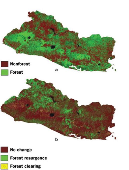
Decadal changes in forest cover in El Salvador, derived from Landsat Thematic Mapper imagery: (a) distribution of forest cover circa 1990 and (b) changes in forest cover between the 1990s and the 2000s.
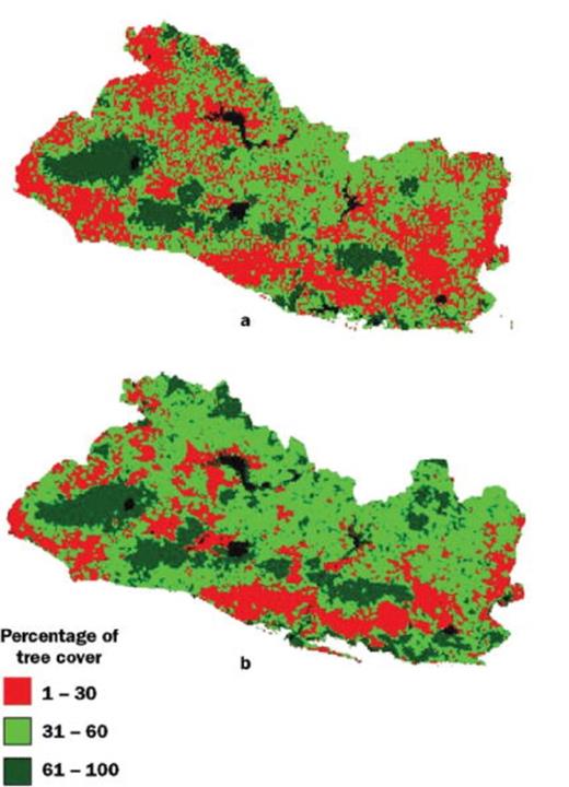
Percentage tree cover in El Salvador, derived from (a) AVHRR (Advanced Very High Resolution Radiometer) at 1-kilometer spatial resolution in 1992 and (b) MODIS (Moderate Resolution Imaging Spectroradiometer) at 500-meter resolution in 2001.
Relationship between population density, remittances (monies sent home by foreign workers), and forest-cover change in El Salvador on a provincial scale between the early 1990s and the 2000s.
Significant correlations between foreign remittances and changes in forest cover in El Salvador: (a) percentage of area of forest resurgence and clearing obtained from the Landsat change detection analysis (forest clearing, R2 = 0.54, P = 0.001; forest resurgence, R2 = 0.31, P = 0.02) and (b) percentage area of forest with more than 30% tree cover, derived from tree-cover change detection analysis (R2 = 0.39, P = 0.02).
Migration and remittances in Central America.
Author notes
Susanna B. Hecht (e-mail: sbhecht@ucla.edu) works in the School of Public Affairs, University of California, Los Angeles, CA 90095.
Sassan S. Saatchi (e-mail: sassan.saatchi@jpl.nasa.gov) is with the Jet Propulsion Laboratory, California Institute of Technology, Pasadena, CA 91011.
