
Keywords
TIRS sensor
Image processing
Software SPRING
How to Cite
Abstract
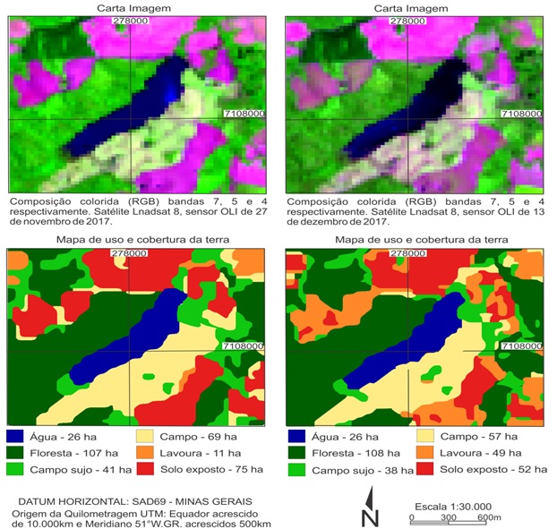
The vegetative cover of the terrestrial surface is one of the factors of the temperature variation of the air found in these places. Thus the objective of the present research is to verify the spatial correlation between land use patterns and surface temperature values (Ts) recorded by the Landsat 8 satellite. The study area is located in the rural area of Francisco Beltrão / PR, characterized by the presence of subsistence agricultural uses. Data from scenes dated 11/27/2017 and 12/13/2017 were processed, both to obtain land cover and land cover maps, as well as surface temperature data. The Ts recorded by each land use class: water, forest, dirty field, field, crop and exposed soil, showed a strong correlation of Pearson, being 0.9116 and 0.9292 respectively for the mapped scenes. When analyzing the homogeneity among the Ts variances of each class, it was verified that mean values do not have a significant minimum similarity between them. The Tukey test indicated that for the first date none of the classes of use presented values similar to each other. By the second date the water and forest classes presented Ts statistically similar, besides the classes of dirty field and field.
References
ARIZA, A. Description y Correccion de Productos Landsat 8. Instituto Geográfico Agustin Codazzi, Bogotá, 2013.
BARSI, J, A.; BARKER, J. L.; SCHOTT, J. R. An atmospheric correction parameter calculator for a single thermal band earth-sensing instrument. In: Geoscience and Remote Sensing Symposium. Toulouse, p. 3014-3016, 2003.
COELHO, A. L. N.; RAMOS, A. L. D.; BERGAMASCHI, R. B. Aplicação dos Produtos Landsat-8/TIRS/OLI e Aster/GDEM na Avaliação do Comportamento Termal de Superfície, Usos e Topografia. XVII Simpósio Brasileiro de Sensoriamento Remoto – SBSR. João Pessoa, p. 1323-1330, 2015.
COLGATON, R. G. A review of assessing the accuracy of classifications of remotely sensed data. Remote Sensing of Environment , v. 49, n. 12, p. 1671-1678, 1991.
ESTEVES, F. A. Fundamentos da Limnologia. 2ª Ed Interciência Rio de Janeiro. 1998. 602 p.
FLORENZANO, T. G. Iniciação em Sensoriamento Remoto: Imagens de satélites para estudos ambientais. 2ª Ed.Oficina de Textos, São Paulo, 2007
FLORENZANO, T. G. Geotecnologias na Geografia Aplicada: difusão e acesso, Revista do Departamento de Geografia, USP no 17, p. 24 – 29. 2005. https://doi.org/10.7154/RDG.2005.0017.0002.
IBGE. Instituto Brasileiro de Geografia e Estatística. Base de Informações do Censo Demográfico 2010: resultados do universo por setor censitário - documentação do arquivo. Rio de Janeiro: IBGE, 2011, 201 p.
IPARDES, Instituto Paranaense de Desenvolvimento Econômico e Social. Leituras regionais: Mesorregião Sudoeste Paranaense. Curitiba, BRDE, 2004, 139 p.
JENSEN, J. R. Sensoriamento Remoto do Ambiente: uma perspectiva em Recursos Terrestres. Traduação de José Carlos Neves Epiphanio. São José dos Campos, SP: Parênteses, 2009. 598 p.
MONTEIRO, C. A. de F.; MENDONÇA, F. Clima urbano. São Paulo. Contexto. 2003
MOREIRA, M., A. Fundamentos do Sensoriamento Remoto e metodologias de aplicação. 3a edição. Viçosa: UFV. 3a edição. 2005.
MOREIRA, M. A. Uso de imagens do Google Earth capturadas através do software stitch map e do TM/Ladsat-5 para mapeamento de lavouras cafeeiras – nova abordagem metodológica. XV Simpósio Brasileiro de Sensoriamento Remoto. Curitiba, p. 481-488. 2011.
NASCIMENTO, I. J. de. Emprego de técnicas de sensoriamento remoto e de geoprocessamento na análise multitemporal do fenômeno de ilhas de calor no município de Goiânia-GO (1986/2010). 96f. Dissertação (Mestrado em Geografia) – Universidade Federal de Goiás, Goiânia, 2011.
NICHOL, J. E. A GIS-Based Approach to Microclimate Monitoring in Singapore’s High-Rise Housing Estates. Photogrammetric Engineering & Remote Sensing, v.60, n. 10, p. 1225-1232, 1994.
NOVO, E. M. L. de M. Sensoriamento remoto: princípios e aplicações. 3a edição. São Paulo, Edgard Blucher, 2008.
OLIVEIRA, A. S. Influência da vegetação arbórea no microclima e uso de praças públicas. Cuiabá,. 2011.
PONZONI, F. J.; Shimabukuro, Y. E. Sensoriamento Remoto no Estudo da Vegetação. Editora Parêntese, São Paulo. 2010.
RIBEIRO, A. G. As Escalas do clima. Boletim de Geografia Teorética, Rio Claro, v. 23, p. 288-294, 1993.
SANTOS, J. S. dos. Campo térmico urbano e sua relação com o uso e cobertura do solo em cidade tropical úmida. Revista Brasileira de Geografia Física, Recife, v. 03, p. 540-557, 2012. https://doi.org/10.26848/rbgf.v5i3.232851.
SOARES FILHO, B. S. Modelagem da dinâmica da paisagem de uma região de fronteira de colonização amazônica. 299f. Tese (Doutorado), Escola Politécnica, Universidade de São Paulo. São Paulo, 1998.
SCHOTT, J. R.; GERACE, A.; RAQUENO, N.; IENTILUCCI, E.; RAQUENO, R.; LUNSFORD, A. W. Chasing the TIRS ghosts: calibrating the Landsat 8 thermal bands, Earth Observing Systems XIX, Califórnia, v. 9218, p. A1 - A20, 2014. https://doi.org/10.1117/12.2063236.
SOUZA, S. B. de; JÚNIOR, L. G. F. Relação entre temperatura de superfície terrestre, índices espectrais e classes de cobertura da terra no município de Goiânia (GO). Revista Espaço Geográfico em Análise. Vol. 26. Paraná, p. 75-99. 2012. https://doi.org/10.5380/raega.v26i0.30151.
TURKMAN, M. A.; SILVA, G. L. Modelos Lineares Generalizados - da teoria à prática. Sociedade Portuguesa de Estatística, Lisboa. 2000.
USGS (United States Geological Survey). Using the USGS Landsat 8 Product. Disponível em: https://landsat.usgs.gov/Landsat8_Using_Product.php .Acesso em: 29.out.2014.
WENG, Q.; LU, D.; SHUBRING, J. Estimation of land surface temperature–vegetation abundance relationship for urban heat island studies. Remote Sensing of Environment. n. 89, p. 467-483, 2004. https://doi.org/10.1016/j.rse.2003.11.005
Authors hold the Copyright for articles published in this journal, and the journal holds the right for first publication. Because they appear in a public access journal, articles are licensed under Creative Commons Attribution (BY), which permits unrestricted use, distribution, and reproduction in any medium, provided the original work is properly cited.