


Historic Introduction
The spectacular grooves crossing the gentle stoss slope and broad crest of Kelleys Island in western Lake Erie (Fig. 1) have evoked “theories of formation” from many geologists since 1840. Quarrying of the uniform pure limestone (Middle Devonian; Columbus Formation), in which they were engraved, started in 1833 and dwindled to small-holding operations after World War I. This provided long-continued rock exposures but it destroyed all large surface grooves except one beautiful example near the North Bay (west-north-west) of the island (Fig. 1). This was given to the State of Ohio in 1925; but it was not fully exposed until recently (1972–73) by the Ohio Historical Society through one of its benefactors and geology student labor from Ohio State University.

Fig. 1. Contour map of Kelleys Island, Ohio, based on the U.S. Geological Survey’s 1959 7½ minute quadrangle. Contour interval 3 m by interpolation. Shaded zones show where quarrying removed grooves or striae. Glacial movement arrows are shown where the lakeside end of “Great Groove” and the remaining groove at Glacial Grooves State Park reached North Bay. In the center lesser grooves are re-buried. The arrows on the north-east shore show two sets of striae common to the smooth limestone surface all along that east shore.
The earliest theorists used terms such as “diluvial boulder action” because the flood idea died slowly. Then Reference GilbertG. K. Gilbert (1873), Reference WinchellN. H. Winchell (1873), Reference WhittleseyCharles Whittlesey (1879), and Reference ChamberlinT. G Chamberlin (1888) all expressed clear glacial origins. The striae in all parts of the grooves, plus the eastern and northern erratics in the filling till, and the up-hill sweep of striae have convinced most skeptics of this. However, Gilbert was impressed by the “smoothed pits and bowls”, so he postulated water falling through the thick ice. Since 1959, with the discovery of water deep below thick (2 000 m) and cold continental ice, many aspects of the water hypotheses have been reviewed. What did happen to that basally melted water from ice which lasted at least 10 000 14C years over this area? Could a slurry of glacial till and melt water under very high pressures produce these smooth up-hill gouges?
These are not the only glacial grooves in the world, although they once were titled “the largest”. A larger area of more drumlinoid forms was discovered in air photographs of a comparable limestone terrain in northern MacKenzie Valley (Reference SmithSmith, 1948). Most grooves in intensively glaciated areas are like the single or second-order grooves here (Reference GjessingGjessing, 1966). Each flute is explainable or related to a weak rock zone (concentrated groove) or a rock hard to abrade (sheltered ridge). Not so here.
This whole western Lake Erie area is prone to glacial fluting. There are secondary grooves and ridges nearly as deep (1 m) on the mainland near the top of Marblehead Peninsula 7.5 km to the south-south-west, and south of Put-in-Bay on South Bass Island, 11 km west-north-west, or 14 km north near the south end of Pelee Island (Fig. 1). All are 240–260° except on Pelee Island where they are nearer 270°. All are in uniform Columbus limestone that crops out as a band 10 km wide from these islands south through central Ohio. Here it stands 24 m above the fissile shale lake bottom of the Erie Basin. Clearly, these are associated with the broad compressional rise of ice out of the Lake Erie Basin over a uniform limestone rock vulnerable to deep carving.
Meaningful Description
The giant grooves on Kelleys Island consist of four size orders of abrasion:
-
1. Each megagroove itself is or was 5–20 m wide and 100–400 m long. Between megagrooves and throughout the limestone region there is mostly a smooth flat striated rock surface under till. The deepest central points in each megagroove, however, are 2–6 m below this smooth surface. The one megagroove left in the Glacial Grooves State Park is 130 m long (Fig. 2) but old pictures show that it extended both 50 m farther west (at 12–15 m elevation above Lake Erie) and 100 m east down to lake level. At least one parallel adjacent groove was found buried just south of this by borings (C. W. Albrecht) and geophysics (H. C. Noltimeier). Others to the north, including the “Great Groove”, were quarried away. Measurements of azimuths over the years vary between 240° and 260°. The megagrooves do curve up to 20°.
-
2. The floor of each megagroove consists of 5–9 second-order sub-grooves or “sine” grooves. They are separated by rounded ridges which form a “sine” curve in cross-section (Fig. 2). The individual second-order grooves and ridges are 10–90 cm in amplitude and extend 5–40 m along the megagroove floor, but never the full length of any megagroove. These ridges are interrupted, gouged on the sides and even cut off, by sweeping smooth lateral depressions at azimuths up to 070° or 090° across the megagroove trend. Early literature called them “scoop marks”(Fig. 3).
-
3. All over the “sine”-groove floor, sides, and ridges there are striae and other individual tool-point marks usually a millimeter or two wide but up to a centimeter wide in places. These third-order striae are about 1 mm deep. They are commonly traceable for 10–100 cm (Figs 3 and 4). They mark the path of the last large tool over that line of surface.
-
4. A high gloss or polish is typical of many glaciated surfaces in quarries through central Ohio, wherever post-glacial solutions have not pitted or roughened rock surfaces under till. Alternatively, some are encrusted with calcium carbonate re-deposited from the till above. Actually, when first uncovered, the glacial grooves, i.e. the Glacial Grooves State Park, had a high gloss or patina which rapidly dulled in a year and chipped off in flakes and grains within 5 years (Fig. 4). Since this gloss can be produced artificially in rock polishing machines using fine rouge powder, and since a clay-till did partially fill each groove, it is deduced that the fine clays of the till matrix did this polishing.
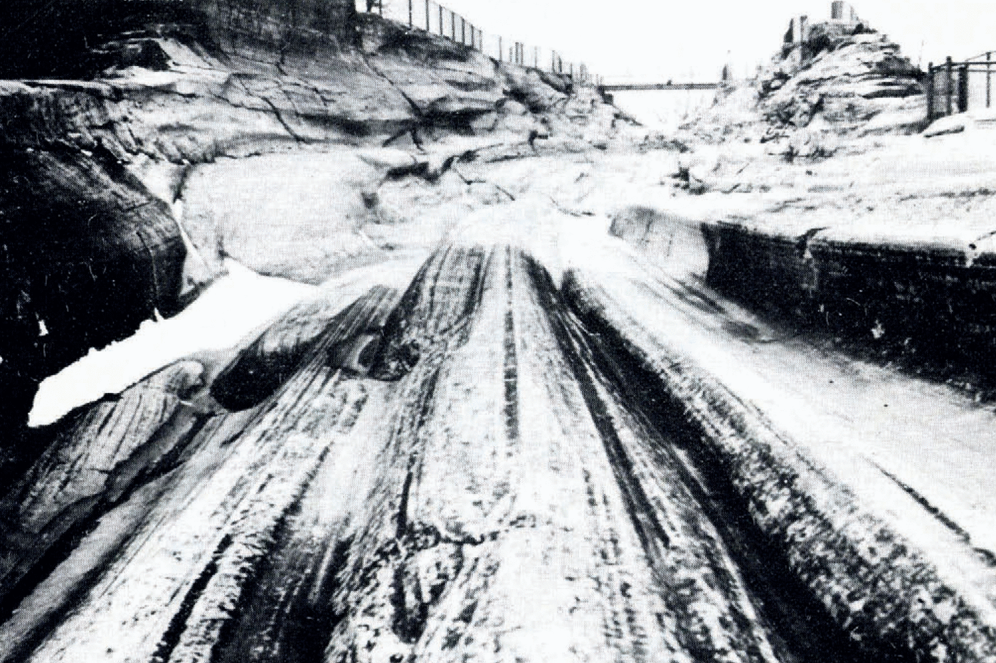
Fig. 2. Megagroove with “sine” grooves. Looking west in the direction of inferred ice flow at Glacial Grooves State Park, Kelleys Island. The second-order sculpture shows both grooves and rounded ridges, 10–90 cm in amplitude, described by Reference CarneyCarney (1910) as “Corinthian columns stacked side by side”. Note the overhang on the right and the decided bend in the grooves in mid picture. The dark foreground was the original “park” exposed early this century; the long lighter stretch beyond was dug out in 1972.
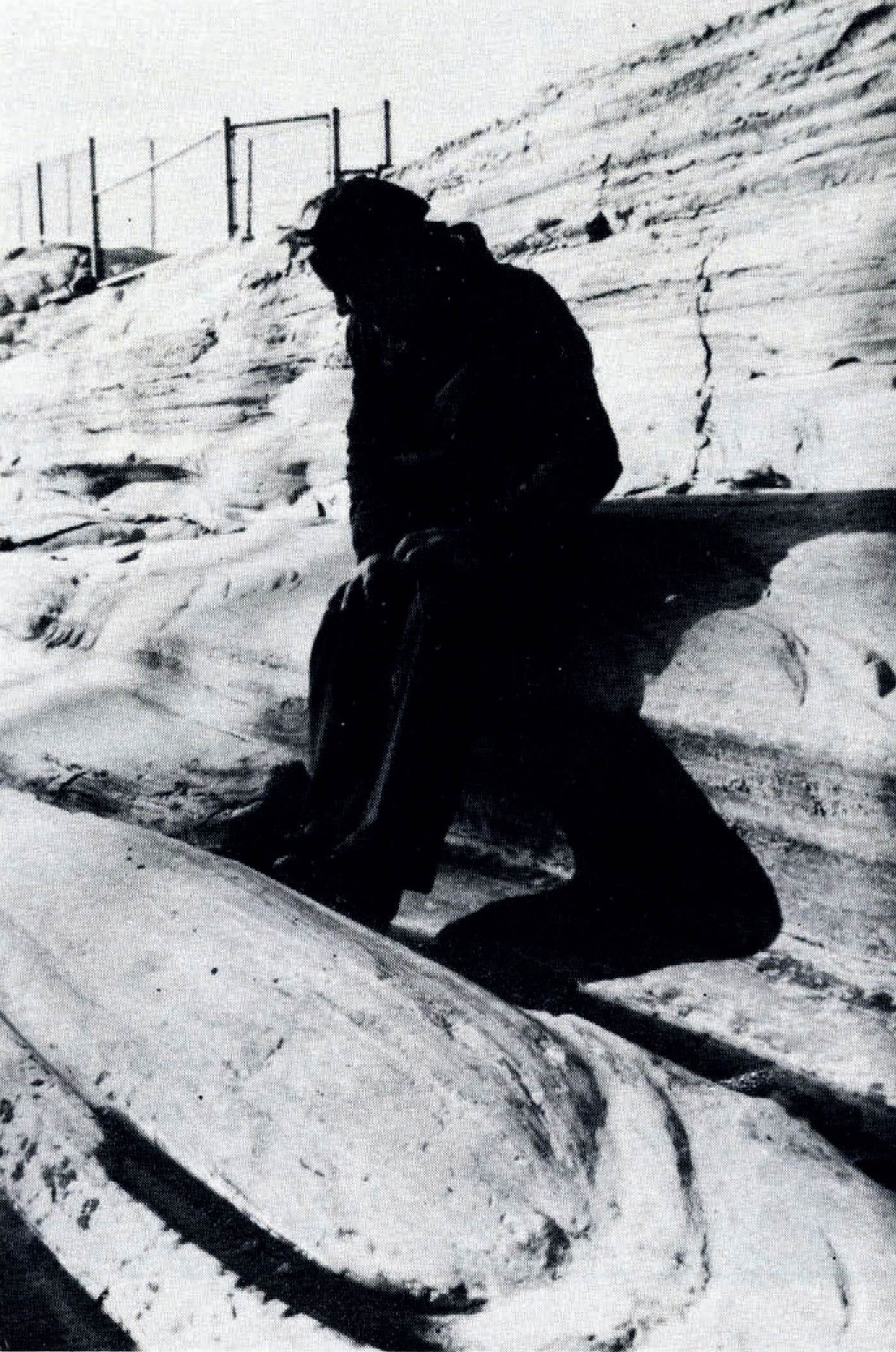
Fig. 3. Scoop marks at the head of a “sine” ridge, Kelleys Island, November 1976. Isolated scoops and undercutting to the right and left of Dr Y. Lavrushin. Others in the lower right wrap around the stoss ridge end. Third-order striae radiate (diverge) up over the ridge. Corals are visible faintly in the ridge head.

Fig. 4. Vertically descending gouge with striae, Kelleys Island, May 1972. This truncates small grooves and ridges in the upper right but it joins end deepens a “sine” groove in the main trend to the west (left center). A plastic cover was used in the upper left to try to preserve the high polish during the first winter of exposure.
Some deductions from second-order ridges
The second-order “sine” ridges are cut away on their sides in many places by all kinds of smooth curved gouges, which also bear some third-order tool-made striae inside. In other words, the scraping tools swept into each curved gouge after the “sine” ridge was essentially formed. This is the last destructional event under ice because gouges sharply cross-cut the uniform ridges (Fig. 3). This action lasted long enough and was vigorous enough to make gouges 1–10 cm deep.
Figure 4 shows a large gouge produced by a vertically descending current of ice or slurry. Such a gouge broadens and its striations curve westward always into the trend of the megagrooves. This shows that the tools were swept along finally in the general flow of the ice or slurry. From the length of the striae and absence of percussion marks, we may deduce that the moving agent was a very viscous plastic; it held its tools in a firm grip for many centimeters. Some mix of ice near its pressure-inciting point, and angular rock debris with hard “tool” points, fits the requirements of basal abrasion better than a water and mud slurry unless the latter is conceived of as sticky and thick.
The head ends of the second-order sine-shaped ridges, as seen from the easterly (down-hill) direction, look like the end of a large half water melon or a huge half-cigar (Fig. 3). Third-order engraved striae radiate up over it and especially around either side into the associated narrower grooves. In fact, the second-order grooves are sharpest, narrowest, and deepest where many striae converge just east of the head of a ridge. This convergence into troughs suggests that 2–10 times as much debris-armed ice or slurry passed through each deep local groove position as rose along adjacent ridges. This can only mean 2–10 times the velocity; if the main ice moved 5–10 m/d at the surface,Footnote * these might well have moved or “squirted” more than 10–100 m/d or 7 cm/min. These were concentrated local streams just at the sole of the glacier.
This deduction of basal lateral concentrations of tools is born out by the up-hill or tail end of some second-order “sine” ridges as well. In all cases the ridge decreases in amplitude (lowers gradually) in 10–40 m. The individual tool striae in adjacent grooves “climb” gradually up on to the ridge from the sides, even criss-crossing striae from the other side (Fig. 5). In other words, the redistribution of engraving tools takes place 10–40 m down-glacier. Fast-moving ice or slurry must dilate and the ridge flattens out where erosion evens out. Presumably, the speed of basal slip becomes uniform too.
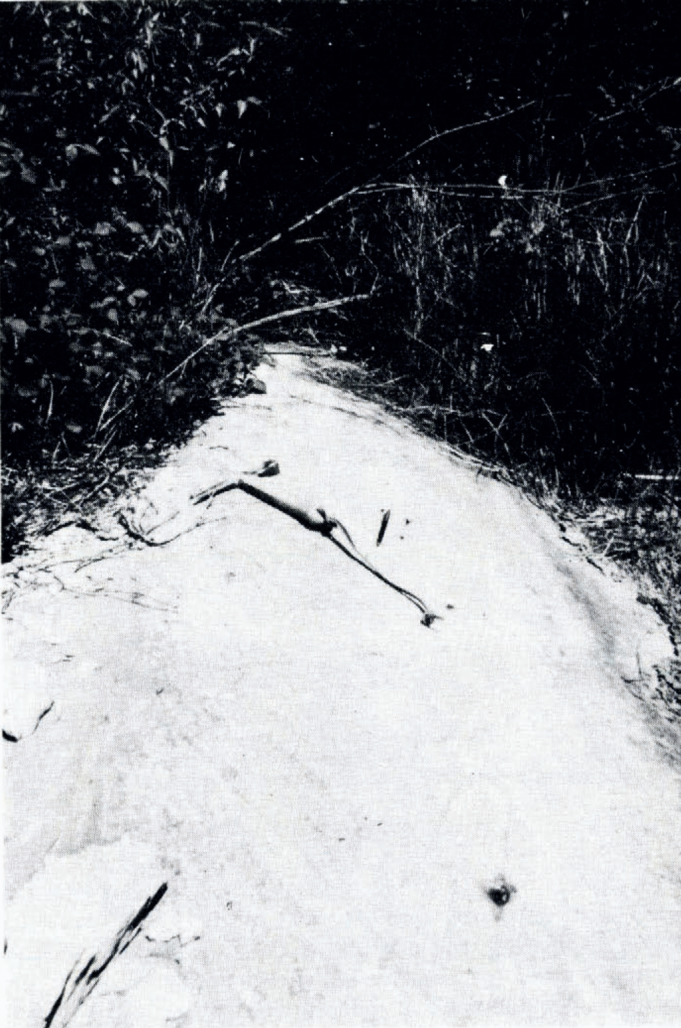
Fig. 5. Criss-crossing striae on the tail “down-glacier” end of one “sine’ ridge, just east of the West Quarry in central Kelleys Island. Striae “climb” out of the grooves on the right and left and cross near the pen and pick handle (25 cm long). The rounded ridge becomes lower in the foreground (bottom).
Symmetrical with the sharp rounded stoss end of some ridges are a series of sharp curved gouges 1–10 cm deep and 10–50 cm long (Fig. 3). They outline the ground plan of the “water-melon structure” 20–100 cm “ahead” of its position, and they “nest” around it. These suggest a possible retrogression of the down-hill head end of the water-melon ridge as vigorous abrasion of oncoming ice or slurry rounded it off.
Hypotheses for the formation of “sine” ridges
No one feature of the grooves causes more speculation than the secondary ridges; why are there any “water-melon ends” giving rise to rounded ridges at all? T. Hughes (unpublished manuscript) first proposed plucking by the ice along natural joints. This Devonian limestone is systematically and broadly jointed with the principal system nearly vertical but cutting diagonally across the grooves (315° and 045°). Any thick plucked blocks, especially on a protruding high and facing oncoming ice, could deflect currents of ice or slurry to either side to initiate the bordering trenches. The blunt end would become rounded and recede. It may be assumed that basal motion is by plastic deformation rather than regelation of features so large.
Many students in class visits from 1947 to 1977 suggest that a large erratic traveling in the basal ice became wedged crosswise in some narrower parts of uniform “sine” grooves. The plastic ice-debris mix (or slurry of till) swirled around and under the boulder, concentrating scour in gouges and narrow grooves, but leaving a ridge in the protected area behind the boulder. However, during excavation of about 250 m3 of till from the groove in the Glacial Grooves State Park, a total of only 203 stones could be found, and not one was big enough to be wedged crosswise.
Shaw and Reference Shaw and FreschaufFreschauf (1973) turned to kinematic waves or helical turning of the basal ice to form some secondary ridges. Certainly, where the rounded ridges are systematic and un-interupted, as at the long-exposed east end of Glacial Groove State Park (Fig. 2) one can envision a very regular longitudinal standing wave parallel to motion.
Reference Lavrushin and GoldthwaitLavrushin and Goldthwait (1978), in reviewing this locality, came back to one of the earliest suggestions, viz. that the ridge ends must be of harder “less-scratchable” rock. In most glaciated areas, such as Baffin Island, Alaska, Greenland, and Spitsbergen, the lesser ridges 10–100 cm wide arise where a tougher lithology has been abraded severely and stands up. Here a number of careful early workers denied any difference in “hardness” from ridge to groove. Yet we found most of the water-melon ends are full of Zaphrentis corals. Conceivably, under pressures of nearly 100 atmospheres, this coralline form of calcite was slightly more resistant to abrasion.
Reference HalletHallet (1976) introduced a new possible factor. Water abrasion had often been considered, and certainly the creation of water, where the ice sole must be at the pressure-melting point, is a well-accepted glaciological principle. However, solution of limestone to calcium bicarbonate might be a new factor under ice, notably on compressional slopes. But the corollary, which is calcite deposition on the lee slopes to westward of the ridges, has not been demonstrated here. Could it occur in such large-scale gross topography?
Hypotheses for concentration of erosion into megagrooves
Few if any observing geologists over the last century would argue that the megagrooves were not at least partly glacial in origin; the surface is completely scored with long striae, whose azimuth is down the length of Erie Basin, and all recorded grooves were at least half-filled with till, bearing erratics from eastern Ontario, and perhaps New York.
There is abundant evidence, however, that all major grooves were located in former small stream courses which flowed eastward down the dip of Columbus limestone (Reference VerSteeg and YunckVerSteeg and Yunck, 1935). Presumably, these were interglacial karst stream courses (lapies). Some evidence was more explicit during quarrying (Fig. 6); there were sharp meanders and plunge basins at the deepest parts of each megagroove. One small “meandering section” is still preserved near the middle of Glacial Grooves State Park. This is why Reference GilbertGilbert (1873) seized upon moulins from water falling through the thick ice as an explanation for their origin.

Fig. 6. Meandering megagroove base. An 1875 photograph of one groove quarried away. North Quarry of Kelleys Island, probably north-west of Glacial Grooves State Park. (This is one of the many original photographs at the Historical Society and Orton Museum, Columbus, Ohio.)
Other compelling evidence that these were once stream courses is that some show shallower side megagrooves entering in dendritic pattern at angles of 10–25°.Footnote * And all megagrooves bend 5–10° as one looks down their axes (Fig. 2). In other words, the basal glacier ice or slurry was deflected in crooked channels with pre-existing tributary courses. This was a local streaming into local creek beds climbing up to the crest of the broad rock divide. These were not the broad streams of surface ice such as described in Vanderford Glacier (Reference Cameron and HadleyCameron, 1965) in Antarctica.
Altogether, this makes for a compressional situation where basal ice near 0°C at minimum viscosity accelerated to pass over a restriction much as in Carol’s (1974) roche moutonnée observations. Locally, volume of ice discharge at the base of the glacier probably exceeded the discharge rate near the ice surface of the glacier. T. Hughes (unpublished manuscript) suggested that this is a concentrated kinematic instability likely over large ice-covered bed projections, where the basal temperate (0°C) ice layer reduces to zero thickness at the highest sites; so the ice freezes on to these highest points (Reference LliboutryLliboutry, 1966).
Time and thickness of ice sheet involved
Many studies of tills, both in southern Ontario north of Lake Erie (Reference Dreimanis and ReavelyDreimanis and Reavely, 1953) and east from Cleveland (Reference WhiteWhite, 1960), define one widespread late Wisconsinan-age till, the Port Stanley or Hiram till. C. C. Rich (unpublished studies) found that it also covers earlier tills in north-western Ohio. Little, if any, sliding abrasion can accompany deposition of such compact till, so megagrooves and “sine” grooves must precede it. Muskopf (unpublished) made a careful study of the compact till which half-filled the megagroove excavated in 1972, and found it identical to the Hiram till in clay content (35–40%), carbonate content (21–25½%), and brown color (7.5 YR 4/4). It is similar in type of clay (68% illite, 27% vermiculite) and in stone count. So, the grooves were completed before this re-advance of ice covered northern Ohio, which came after the Erie interstade 15 500 14C years ago (Reference Dreimanis and GoldthwaitDreimanis and Goldthwait, 1975).
In Glacial Grooves State Park and in the giant grooves excavated last century, the Hiram till was covered by 5–80 cm of laminated fine sands and coarse silts. This is interpreted as lacustrine sediment and is common to all the western basin, less than 70 m above Lake Erie. In the western two-thirds of the Lake Erie Basin, glacial lakes Maumee, Arkona, Whittlesey, Warren, and Wayne are demonstrated to have had water surfaces well above the highest parts of all islands in western Lake Erie. All lakes, especially the last two, left silts. Radiocarbon dates of 13 600–11 300 yearsFootnote * apply to all these except the first (Maumee) stage. The weathering and pitting of the upper groove walls began when ice dams disappeared and water receded to a level lower than today, which was no later than 11 000 years ago.
The till itself, both in the grooves and in the region, is fresh and unleached. The deepest leaching is hardly 60 cm in soils of well-drained tills in the region. The surface of the bedrock beneath the till is fresh, polished, and unleached, whether buried 0.5, 1, or 2 m deep. Such thin soils in drift and fresh bedrock never characterize any penultimate (Illinoian) glaciated area, so these grooves were at least freshened and finished within the late Wisconsinan glaciation. The invasion of the last ice is generally dated by lacustrine and organic deposits, which were over-run at Garfield Heights, Toledo, and Port Talbot about 24 000–25 000 years ago (Reference Dreimanis and GoldthwaitDreimanis and Goldthwait, 1975). The glacial grooves could have been shaped out of pre-glacial stream beds anytime between 24 000 and 15 000 14C years ago.
Possibly some surface abrasion occurred during all these 8 500 years. At 1 mm/year,Footnote * this might even have accomplished the whole job. But most visiting geologists, impressed with the magnitude of the erosion, have suggested that the bulk of the erosion was during the 4 500 years of thickest ice, a period lasting from 21 500 to 17 000 14C years ago (Reference Dreimanis and GoldthwaitDreimanis and Goldthwait, 1975). Early in a long glacial cycle is an unlikely time for erosion as the ground is often deeply frozen during cold summers of ice advance and ice is inferred to be everywhere frozen to its base (Reference Goldthwait, Fahey and ThompsonGoldthwait, [C1973]). There is no basal slip. It takes centuries for Earth heat to drive the zero isotherm up to the base of the glacier once it covers frozen land. Any turbulence that may produce the second-order swirling cuts has never been observed in erosion near existing glacier margins nor in tunnels up to 400 m back from the ice edge (Reference GoldthwaitGoldthwait, 1960).
If Greenland and Antarctica are representative examples, the actual depth of ice 300–500 km back from the Wisconsinan ice margin was at least 1 500 to 2 000 m; and these may be conservative depths if one postulates a peripheral snow-feeding center over the Lake Erie Basin. Does such visco-plastic ice with any mix of debris, under the confining pressures of 100 bar and at its pressure-melting point, have any properties which allow it to gouge out pure limestone? Hence the jetting action appears to be generated by vortices set into motion by the deep meandering topography of rather small pre-glacial valleys.


